Built in 1835. Listed on the National Register of Historic Places in
1984. A historic map-sheet match is not published yet. The record needs a coordinate-quality review before it can be joined to a sheet boundary.
From the record
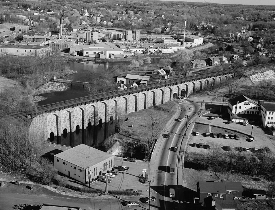
“Canton Viaduct is a blind arcade cavity wall in Canton, Massachusetts, built in 1834-35 for the Boston and Providence Railroad.”
Wikipedia article Canton Viaduct, CC BY-SA 4.0.
one of 249 National Register listings in Norfolk County · listed in 1984 · category: Structure · built in 1835, by William Gibbs McNeill, George Washington Whistler · one of 2 National Historic Landmarks in Norfolk County.
Architect. William Gibbs McNeill, George Washington Whistler
National Register reference number.84002870- the number the National Park Service assigned this property when it was listed, and the key its nomination file is catalogued under at the National Archives.
Fires near this property
184 since 2015
Regional context, not property-specific
evidence. The
federal wildfire occurrence database
lists 184 fires within 5 miles of Canton Viaduct between
2015 and 2020, burning about 67 acres in total. 1 started naturally. 1 was recorded as arson.
Distance is straight-line from the map coordinates, so a fire counted
here may appear on a neighbouring settlement's page as well.
Reported cause
Fires
Recreation and ceremony
83
Missing data/not specified/undetermined
45
Smoking
45
Debris and open burning
6
Equipment and vehicle use
2
Natural
1
Arson/incendiarism
1
Other causes
1
The most recent of
them, most recent first, with the day each was reported and the service
that recorded it.
Regional context, not property-specific
evidence. Museums hold 7,541 specimens
collected within 10 miles of Canton Viaduct between 1832 and
1975: 3,174 Plantae, 2,397 Animalia, 1,779 Fungi, 137 Protozoa, 26 Chromista, 23 Unrecorded, 5 Bacteria. 12 distinct Species records are shown.
Collected by (MARSDEN, H W), ?, A W Cheever and others. Each is a
physical object with a catalogue
number, and each entry opens the museum's record. This is what was
collected and kept, not a survey of what lives here - nothing can be
concluded from a species being absent.
Regional context, not property-specific
evidence. The federal mineral resources record lists
13 workings within 5 miles of Canton Viaduct: 8 past producers, 3 producers, 1 unknown, 1 occurrence.
3 still produce. What was taken out: Sand and Gravel, Construction, Iron, Stone, Crushed/Broken, Granite. Distance is straight-line from the
map coordinates, so a quarry counted here may appear on a neighbouring
settlement's page as well.
Regional context, not property-specific
evidence. The National Weather Service names
Canton, the town this property stands in, in 3 storm reports between 2016 and 2025: 2 thunderstorm wind, 1 flood.
No death or injury is recorded in these reports. Each account below is quoted exactly as the forecast office
filed it, from the NOAA Storm Events Database, and each date
opens the federal record of that event.
No historic map-sheet match is published
for this property yet. That does not mean no map exists. This record needs
a coordinate-quality review before it can be joined to a sheet boundary.
Browse the county's mapped places while that work is
pending.
Named in the fire insurance atlases
Sanborn surveyors printed an index of the
town's establishments at the front of each atlas. This property is named in
one, read straight off the scanned sheet.
When this property was proposed for the
National Register, someone wrote the case for it: what the building is,
and why it matters. That document is a federal record in the public domain.
It is quoted below word for word, never summarised. The text was read off the scanned case file by machine, so the
occasional stray character is the recogniser's and the 1970s
typewriter's.
Description of the property
NA The Canton Viaduct is a multiple-arch granite viaduct 615 feet in length, 22 feet wide, and approximately 70 feet above the surface of the East Branch of the Neponset River. The viaduct was the principal structure on the Boston & Providence Railroad's main line, and the last to be completed, opening July 28, 1835. At the time, noted Hayward's Gazeteer of 1847, the structure was "widely conceded the most elegant and massive structure of masonry in the United states."1 In an unusual departure from contemporary construction practice, the structure is not solid, composed instead of two parallel walls, 4 feet apart and each 5 feet thick, extending the entire length of the viaduct.
At intervals of 27-1/2 feet, the walls are connected with buttresses 5-1/2 feet thick, extending transversely across the walls and projecting 4 feet beyond their faces.2 A series of segmental arches link the buttresses at the top of the viaduct, supporting the cantilevered roadbed. At the base of the viaduct, six rounded arches 8 feet 4 inches in span allow the East Branch to pass beneath, while Neponset Street passes through a larger 22-1/2-foot arch. Foundations of the structure extend to a depth of eight feet below the ground level. The entire viaduct is built on a 1-degree curve. In 1860 a second track was laid on the narrow structure.
To accomplish this, the original parapet walls were removed and a skeleton platform constructed of transverse double-cantilever wooden beams on top of the masonry and under the track rails.3 This placed the outer rail of each track directly over the arches. Although the wooden beams were replaced by those of iron in 1880, the increasing weight of trains directly on the arches finally caused a failure of several arches in 1909.
(in one paragraph) Builder/Architect William Gibbs McNeill, Dodd and Baldwin The Canton Viaduct possessesintegrity of location, design, setting, materials, and workmanship. The viaduct is significant structure as well as for its association with the development of the Boston & Providence Railroad. The engineers responsible for its construction, William Gibbs McNeill and George Washington Whistler, were then among the nation's preeminent railroad engineers. Together with the Baltimore & Ohio's Carrolton and Thomas viaducts (constructed in 1829 and 1835 respectively), the structure is one of the oldest surviving multiple-arch stone railroad bridges in the United States. The structure thus meets criteria A, B, C, and D of the National Register of Historic Places.
The East Branch of the Neponset provided one of the most important collection of mill privileges in this part of the county, and from 1700 on, the nearby village of South Canton was the industrial center of town and the surrounding area. In addition to the ordinary saw and grist mills, a gunpowder mill operated here prior to and during the Revolution; Leonard & Kinsley produced some of the first steel implements in the country; and in 1800, less than 100 yards above the future site of the viaduct, Paul Revere constructed one of the first copper rolling mills. The same distance downstream is the site of the earliest cotton spinning mill in Massachusetts, established by James Beaumont in 1803. Later manufacturers would include large factories for the production of silk and stove polish.
The coming of the railroad was an important factor in the industrial growth of South Canton. The Boston & Providence Railroad was incorporated in 1831. In laying out the railroad, nine different routes between Boston and Providence were considered.
Quoted from the National Register nomination
for reference 84002870, 12 pages, held by the National Archives in Record
Group 79. See the
catalogue record.
Listed places nearby
6 within 8 miles
Other National Register properties close
enough to walk or drive between, ordered by distance from this one. Both
positions come from the same geocoding pass that matched these properties
to their map sheets.
Listing record. National Park Service National Register of Historic Places, listed-properties dataset, current to 2026-05-22.
Map join. Address geocoded through the United States Census geocoder, then tested against the published boundary of every sheet in the USGS Historical Topographic Map Collection.
How this page is made. Listing fields come from federal records; map-sheet coverage is a labelled coordinate-to-boundary calculation, not a source-field claim.
Wildfire. Short, Karen C. 2022. Spatial wildfire occurrence data for the United States, 1992-2020 [FPA_FOD_20221014]. 6th Edition. Fort Collins, CO: Forest Service Research Data Archive. https://doi.org/10.2737/RDS-2013-0009.6 Collected with United States Government funding and usable without additional permissions or fees.
Specimens. Global Biodiversity Information Facility (GBIF), https://www.gbif.org/. Only records licensed CC0 or CC BY are used. Records licensed CC BY-NC are excluded because this site carries advertising. Images are checked individually and any whose licence is non-commercial, no-derivatives or unreadable is refused.
Mines and quarries. USGS Mineral Resources Data System (MRDS) https://mrdata.usgs.gov/mrds/ A work of the United States government, no copyright under 17 U.S.C. 105.
Storms. NOAA National Centers for Environmental Information, Storm Events Database https://www.ncei.noaa.gov/stormevents/ A work of the United States government, no copyright under 17 U.S.C. 105. Narratives are quoted verbatim from the National Weather Service report and are not edited or summarised.
 Block
Block