Photographs from the nomination case file, National Park Service records.
Black Tavern
Listed on the National Register of Historic Places in
1985. A historic map-sheet match is not published yet. The record needs a coordinate-quality review before it can be joined to a sheet boundary.
From the record
one of 500 National Register listings in Worcester County · listed in 1985 · category: Building · one of 1 National Historic Landmarks in Worcester County.
National Register reference number.85000981- the number the National Park Service assigned this property when it was listed, and the key its nomination file is catalogued under at the National Archives.
Fires near this property
41 since 2015
Regional context, not property-specific
evidence. The
federal wildfire occurrence database
lists 41 fires within 5 miles of Black Tavern between
2015 and 2020, burning about 18 acres in total. None started naturally. 2 were recorded as arson.
Distance is straight-line from the map coordinates, so a fire counted
here may appear on a neighbouring settlement's page as well.
Reported cause
Fires
Debris and open burning
20
Missing data/not specified/undetermined
10
Recreation and ceremony
6
Arson/incendiarism
2
Smoking
2
Power generation/transmission/distribution
1
The most recent of
them, most recent first, with the day each was reported and the service
that recorded it.
Regional context, not property-specific
evidence. Museums hold 403 specimens
collected within 10 miles of Black Tavern between 1875 and
1975: 201 Animalia, 160 Plantae, 38 Fungi, 2 Chromista, 1 Unrecorded, 1 Protozoa. 12 distinct Species records are shown.
Collected by A. R. Hodgdon; F. L. Steele, A. S. Pease, B. Gates and others. Each is a
physical object with a catalogue
number, and each entry opens the museum's record. This is what was
collected and kept, not a survey of what lives here - nothing can be
concluded from a species being absent.
Regional context, not property-specific
evidence. The federal mineral resources record lists
13 workings within 5 miles of Black Tavern: 11 past producers, 2 producers.
2 still produce. What was taken out: Sand and Gravel, Construction, Stone, Crushed/Broken. Distance is straight-line from the
map coordinates, so a quarry counted here may appear on a neighbouring
settlement's page as well.
Regional context, not property-specific
evidence. The National Weather Service names
Dudley, the town this property stands in, in 15 storm reports between 1993 and 2023: 10 thunderstorm wind, 3 flood, 2 hail.
The reports record 2 injuries. Each account below is quoted exactly as the forecast office
filed it, from the NOAA Storm Events Database, and each date
opens the federal record of that event.
Heavy rain fell in Dudley which overwhelmed the drainage system and resulted in some minor flooding of the Dudley District Court. Four inches of water covered the lower level of the courtroom while up to a foot of water was reported in the back parking lot. Quick action by courtroom personnel prevented any further damage to paperwork or equipment.
At 538 PM EST, West Main Street in Dudley was flooded and impassable near the Connecticut State Line. Also, Southbridge Road near near the Connecticut State Line was also flooded and impassable. Also, at 626 PM EST Center Road was flooded and impassable.
No historic map-sheet match is published
for this property yet. That does not mean no map exists. This record needs
a coordinate-quality review before it can be joined to a sheet boundary.
Browse the county's mapped places while that work is
pending.
From the nomination file
3,798 words on record
When this property was proposed for the
National Register, someone wrote the case for it: what the building is,
and why it matters. That document is a federal record in the public domain.
It is quoted below word for word, never summarised. The text was read off the scanned case file by machine, so the
occasional stray character is the recogniser's and the 1970s
typewriter's.
Description of the property
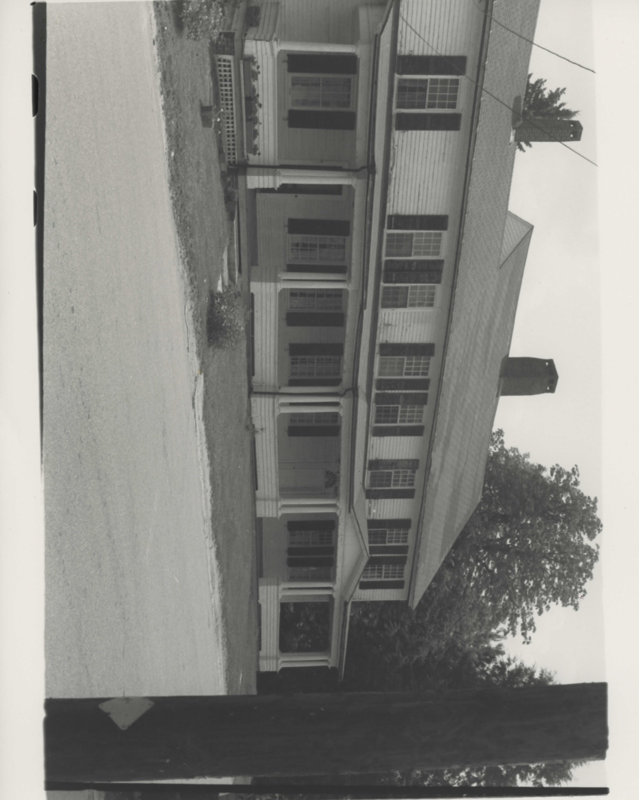
Located in the geographic center of Dudley, Massachusetts, atop Dudley Hill, 600 feet above sea level, the Black Tavern occuples a corner lot at the intersection of Dudley Hill Center Road andlanyardRoad. The building, which faces west, is set back approximately 20 feet from the road. Alongside its southern elevation are several mature trees, while the front lawn is simply planted with grass. The lot slopes away steeply behind the front of the building. To the immediate north of the building stands a former shoe shop (ca. 1805, #54), now a college dormitory. Typically Federal in its design, the tavern is rectangular in shape, with two ells added (see attached plan). Its main section, built 1n 1803-1804, 1s a five-day, center-entry, - 1/2-story building.
It has a central chimney centered on the ridge. To the east, rear of the building, a carpenter shop, 1 1/2 stories with a full basement, was added in 1810. In 1835, a three-bay, two-story ell, with central entry, was added on to the north side of the tavern. The main part of the building and its northern ell rise from a rough-quarried granite foundation, while the eastern ell sits on a raised brick foundation. The tavern is sheathed in clapboard throughout, except for the above-ground brick basement of the eastern ell, and plain corner boards frame the building. While it is believed that the original roof shingles were wooden, the present roofing material is asphalt.
Much of the original fenestration, which is primarily 12/12 double-hung sash, remains Shutters surrounding many of the windows are also thought to be original. The main,western facade of the originalblock is composed of five symmetrically arranged bays. Two simply framed windows flank a finely detailed doorway: dentilated pediment and fluted pilasters frame a semi-circular fanlight and paneled door.
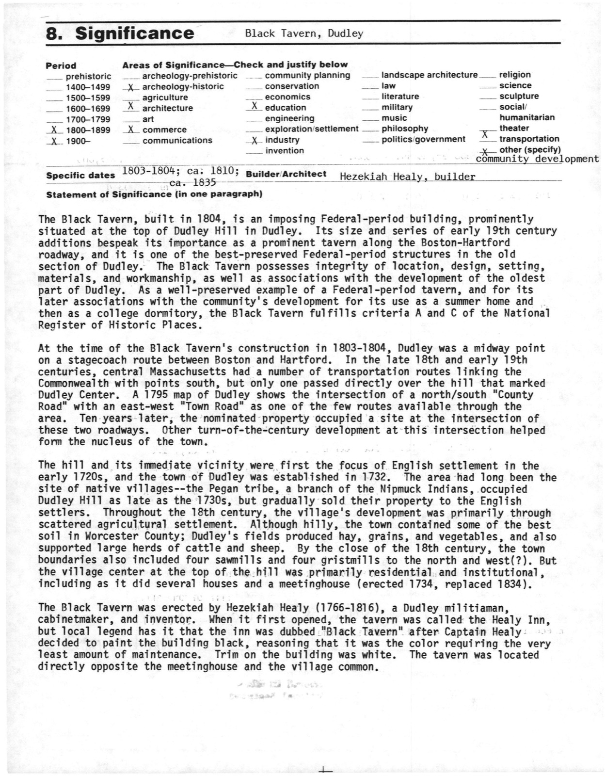
/Architect Hezekiah Healy, builder ca. 1835 Statement of Significance (in one paragraph) The Black Tavern, built 1n 1804, is an imposing Federal-period building, prominently situated at the top of Dudley Hill in Dudley. Its size and series of early 19th century additions bespeak its importance as a prominent tavern along the Boston-Hartford roadway, and it is one of the best-preserved Federal-period structures in the old section of Dudley. The Black Tavern possesses integrity of location, design, setting, materials, and workmanship, as well as associations with the development of the oldest part of Dudley.
As a well-preserved example of a Federal-period tavern, and for its Tater associations with the community's development for its use as a summer home and then as a college dormitory, the Black Tavern fulfills criteria A and C of the National Register of Historic Places. At the time of the Black Tavern's construction in 1803-1804, Dudley was a midway point on a stagecoach route between Boston and Hartford. In the late 18th and early 19th centuries, central Massachusetts had a number of transportation routes linking the Commonwealth with points south, but only one passed directly over the hill that marked Dudley Center. A 1795 map of Dudley shows the intersection of a north/south "County Road" with an east-west "Town Road" as one of the few routes available throughthe area.
Ten years-later, the nominated property occupied a site at the intersection of these two roadways. Other turn-of-the-century development at this intersection helped form the nucleus of the town. The hill and its immediate vicinity were first the focus of English settlement in the early 1720s, and the town of Dudley was established in 1732.
Quoted from the National Register nomination
for reference 85000981, 12 pages, held by the National Archives in Record
Group 79. See the
catalogue record.
Listed places nearby
6 within 8 miles
Other National Register properties close
enough to walk or drive between, ordered by distance from this one. Both
positions come from the same geocoding pass that matched these properties
to their map sheets.
Listing record. National Park Service National Register of Historic Places, listed-properties dataset, current to 2026-05-22.
Map join. Address geocoded through the United States Census geocoder, then tested against the published boundary of every sheet in the USGS Historical Topographic Map Collection.
How this page is made. Listing fields come from federal records; map-sheet coverage is a labelled coordinate-to-boundary calculation, not a source-field claim.
Wildfire. Short, Karen C. 2022. Spatial wildfire occurrence data for the United States, 1992-2020 [FPA_FOD_20221014]. 6th Edition. Fort Collins, CO: Forest Service Research Data Archive. https://doi.org/10.2737/RDS-2013-0009.6 Collected with United States Government funding and usable without additional permissions or fees.
Specimens. Global Biodiversity Information Facility (GBIF), https://www.gbif.org/. Only records licensed CC0 or CC BY are used. Records licensed CC BY-NC are excluded because this site carries advertising. Images are checked individually and any whose licence is non-commercial, no-derivatives or unreadable is refused.
Mines and quarries. USGS Mineral Resources Data System (MRDS) https://mrdata.usgs.gov/mrds/ A work of the United States government, no copyright under 17 U.S.C. 105.
Storms. NOAA National Centers for Environmental Information, Storm Events Database https://www.ncei.noaa.gov/stormevents/ A work of the United States government, no copyright under 17 U.S.C. 105. Narratives are quoted verbatim from the National Weather Service report and are not edited or summarised.
 Block
Block