Built in 1825 in the Second Empire architecture in the United States and Canada. Listed on the National Register of Historic Places in
1986. A historic map-sheet match is not published yet. The record needs a coordinate-quality review before it can be joined to a sheet boundary.
From the record
“The Tobey Homestead was a historic farmhouse located at the crossroads of Main Street and Sandwich Road in Wareham, Massachusetts.”
Wikipedia article Tobey Homestead, CC BY-SA 4.0.
one of 93 National Register listings in Plymouth County · listed in 1986 · category: Building · built in 1825, Second Empire architecture in the United States and Canada · one of 1 National Historic Landmarks in Plymouth County.
Architectural style. Second Empire architecture in the United States and Canada, Federal architecture
National Register reference number.86001219- the number the National Park Service assigned this property when it was listed, and the key its nomination file is catalogued under at the National Archives.
Fires near this property
136 since 2002
Regional context, not property-specific
evidence. The
federal wildfire occurrence database
lists 136 fires within 5 miles of Tobey Homestead between
2002 and 2020, burning about 39 acres in total. 1 started naturally. 4 were recorded as arson.
Distance is straight-line from the map coordinates, so a fire counted
here may appear on a neighbouring settlement's page as well.
Reported cause
Fires
Debris and open burning
66
Missing data/not specified/undetermined
33
Misuse of fire by a minor
14
Smoking
9
Recreation and ceremony
6
Arson/incendiarism
4
Equipment and vehicle use
3
Natural
1
The most recent of
them, most recent first, with the day each was reported and the service
that recorded it.
Regional context, not property-specific
evidence. Museums hold 2,232 specimens
collected within 10 miles of Tobey Homestead between 1837 and
1975: 1,143 Animalia, 668 Plantae, 321 Fungi, 73 Chromista, 23 Bacteria, 4 Unrecorded. 12 distinct Species records are shown.
Collected by A. B. Seymour, A. C. Mathieson, A. H. Moore and others. Each is a
physical object with a catalogue
number, and each entry opens the museum's record. This is what was
collected and kept, not a survey of what lives here - nothing can be
concluded from a species being absent.
Regional context, not property-specific
evidence. The federal mineral resources record lists
4 workings within 5 miles of Tobey Homestead: 4 past producers.
None of them still produces. What was taken out: Sand and Gravel, Construction. Distance is straight-line from the
map coordinates, so a quarry counted here may appear on a neighbouring
settlement's page as well.
Regional context, not property-specific
evidence. The National Weather Service names
Wareham, the town this property stands in, in 9 storm reports between 1997 and 2020: 3 flood, 2 flash flood, 2 thunderstorm wind, 1 heavy rain.
No death or injury is recorded in these reports. Each account below is quoted exactly as the forecast office
filed it, from the NOAA Storm Events Database, and each date
opens the federal record of that event.
A microburst occurred in Wareham with a thunderstorm associated with a band from superstorm Sandy. A swath of 60 to 70 mph wind gusts occurred with pockets of 80 to 90 mph gusts. The hardest hit locations in Wareham were Swifts Beach, Pinehurst, and Onset Bay Marina. The survey team determined that a damage area of 2 miles in length and 2 miles in width in this area. Based on radar signatures and eyewitness accounts, thunderstorm wind damage began in Falmouth around 6:25PM, then became more intense over Wareham around 6:40PM. The survey team determined that approximately 100 trees were significantly damaged or knocked down in Wareham, with many bringing down wires. The initial downdraft occurred in Swifts Beach then headed north-northeast over Pinehurst toward Narrows Road. In the Swifts Beach area there were numerous downed trees with one tree impaling the roof of a house on Sherman Street. Other points of interest were located on Pilgram Avenue, Judson Street, Pine Street, and Swifts Beach Road. Trees were also downed near the fire department on Main Street in downtown Wareham. Trees were also downed on Church Avenue at t he Redwood Park Elderly Complex. In the Pinehurst area of Wareham, downed trees were evident on Franconia Avenue and Pinehurst Drive. On Narrows Road, a couple of trees were knocked down across the road. In the Onset Bay Marina area, boats that were stored on a 3 story tier were tilted in their racks. A sailboat in the marina was tilted 90 degrees with the mast parallel with the water for about 2 minutes before righting itself. Additionally, 2 boats of unknown size were reportedly sunk in the downdraft. In the Nanumett Heights section of Point Independence (in Onset), significant tree damage was confirmed on Prospect and Webster Streets. The survey team and eyewitness accounts observed much of the tree damage to be oriented in a south to north direction, confirming a microburst.
In Wareham, a car was stuck in flood waters on the Cranberry Highway. A portion of Long Pond Road in Plymouth was flooded with over one foot of water near Gunners Exchange Road.
A south Wareham underpass was covered with 2 feet of water. A car was stuck in flood waters at the intersection of Cranberry Highway and Red Brook Road.
In Wareham, a trailer park was evacuated due to two feet of water, water was coming out of manhole covers on Route 28 by Tobee Road and a railroad underpass was flooded on Main Street near Tobee Road. One lane of Route 6 was closed due to flooding near the Old Rochester Regional High School in Marion.
No historic map-sheet match is published
for this property yet. That does not mean no map exists. This record needs
a coordinate-quality review before it can be joined to a sheet boundary.
Browse the county's mapped places while that work is
pending.
From the nomination file
4,162 words on record
When this property was proposed for the
National Register, someone wrote the case for it: what the building is,
and why it matters. That document is a federal record in the public domain.
It is quoted below word for word, never summarised. The text was read off the scanned case file by machine, so the
occasional stray character is the recogniser's and the 1970s
typewriter's.
Description of the property
The Tobey Homestead, Wareham, was built ca. 1825 and remodelled ca. 1870. It sits on a low rise in the center of Wareham, a coastal town on Buzzards Bay. The property faces east overlooking the Wareham Narrows Bridge (also known as Nicholson Bridge). To the rear of the property is the Tobey Hospital complex, separated from the house by an asphalted parking area; to the south are the driveway and access space for the Tobey Hospital Emergency Room. The eastern and northern sides of the property retain a sloping lawn, clipped hedges, and a low granite retaining wall. The property's southern neighbor is the Alden Besse House. (ca. 1835)The nominated property is set back approximately 30 feet from the intersection of Main Street and the Narrows Bridge (Sandwich Road, or Route 6).
While the house is located at the front of a lot of some 30 acres, the lot includes Tobey Hospital. Only the area immediately around the house, encompasing half an acre, is included within the nomination. The hospital complex includes associated storage buildings, a small administrative building, and a trailer within the above-mentioned Emergency Room access area. The Hospital has announced plans to expand the Emergency Wing out toward the Tobey Homestead, but not within the area proposed for listing on the National Register. A 1985 fire destroyed a number of the small outbuildings previously associated with the house, and burned part of the rear ell. The main body of the house and its back wing suffered only some minor fire and smoke damage.
In appearance, the house is generally Second Empire in style and detail, the result of a ca. 1870 remodelling of a preexisting Federal-period structure.
/Architect Unknown Statement of Significance (in one paragraph) The Tobey Homestead, Wareham, retains integrity of location, design, setting, materials, workmanship, and association. Built ca. 1825 as a late-period Federal-style residence, the house was altered ca. 1870 with the application of well-executed Second Empire features. It retains its Federal-period plan and details, and thus today the building is architecturally significant as an amalgamation of these two distinct 19th century styles. It is historically significant for its associations with a locally prominent industrial family, the Tobeys, whose iron foundry and philanthropic efforts contributed greatly to Wareham's 19th century development.
The Tobey Homestead thus fulfils Criteria B and C of the National Register of Historic Places on the local level. Three rivers, the Weweantic, the Wankinco, and the Agawam, flow through War eham. The nominated property is located on a prominent location overlooking the Wareham Narrows near the mouth of the Agawam River. built in Wareham's center ca. 1825 by Jared Pratt, a native of nearby Middleborough, who with his brother Isaac had founded the Wareham Iron Works in Iron-related industries dominated Wareham's economic development for much of the 19th century, made possible by the town's fortuitous combination of excellent waterpower, ready access to the 18th century ironworking skills of interior Plymouth County artisans, and a rapidly developing coastal trade in iron ore and products.
While the iron industry throughout the colonial period had used locally obtained bog and pond ore from interior Plymouth County, by the late 18th century rock ore from New Jersey mines became preferable. By 1804, ore was transported from Egg Harbor, N.J., to Wareham by sloop, and processed there in local blast and air furnaces.
Quoted from the National Register nomination
for reference 86001219, 17 pages, held by the National Archives in Record
Group 79. See the
catalogue record.
Listed places nearby
4 within 8 miles
Other National Register properties close
enough to walk or drive between, ordered by distance from this one. Both
positions come from the same geocoding pass that matched these properties
to their map sheets.
Listing record. National Park Service National Register of Historic Places, listed-properties dataset, current to 2026-05-22.
Map join. Address geocoded through the United States Census geocoder, then tested against the published boundary of every sheet in the USGS Historical Topographic Map Collection.
How this page is made. Listing fields come from federal records; map-sheet coverage is a labelled coordinate-to-boundary calculation, not a source-field claim.
Wildfire. Short, Karen C. 2022. Spatial wildfire occurrence data for the United States, 1992-2020 [FPA_FOD_20221014]. 6th Edition. Fort Collins, CO: Forest Service Research Data Archive. https://doi.org/10.2737/RDS-2013-0009.6 Collected with United States Government funding and usable without additional permissions or fees.
Specimens. Global Biodiversity Information Facility (GBIF), https://www.gbif.org/. Only records licensed CC0 or CC BY are used. Records licensed CC BY-NC are excluded because this site carries advertising. Images are checked individually and any whose licence is non-commercial, no-derivatives or unreadable is refused.
Mines and quarries. USGS Mineral Resources Data System (MRDS) https://mrdata.usgs.gov/mrds/ A work of the United States government, no copyright under 17 U.S.C. 105.
Storms. NOAA National Centers for Environmental Information, Storm Events Database https://www.ncei.noaa.gov/stormevents/ A work of the United States government, no copyright under 17 U.S.C. 105. Narratives are quoted verbatim from the National Weather Service report and are not edited or summarised.
 Block
Block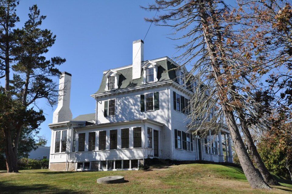

,_quintonil.jpg)