BlockBefore
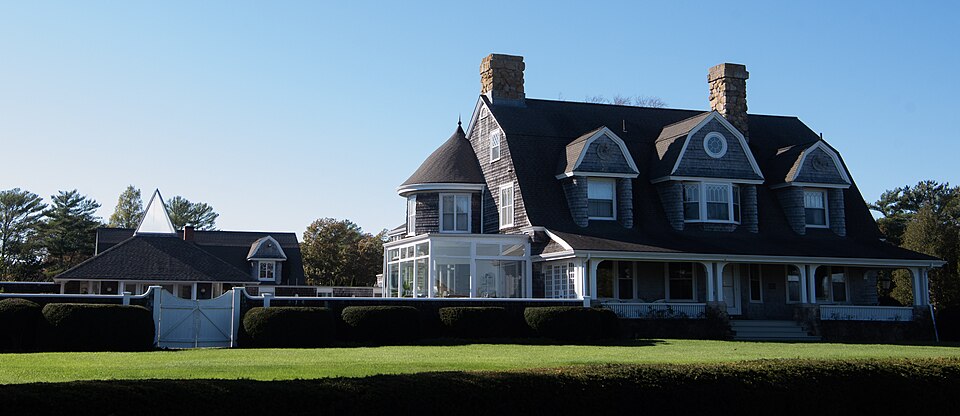
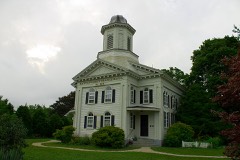
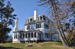
Photograph of H. R. Reed House
Photograph by Triple cErbEru5, CC BY-SA 4.0. Via Wikimedia Commons.

Reed, H.R., House

Listed on the National Register of Historic Places in 2019. A historic map-sheet match is not published yet. The record needs a coordinate-quality review before it can be joined to a sheet boundary.

From the record

“Reed House is a historic house at 46 Water Street in Marion, Massachusetts. Built in 1886, it is a good example of a Shingle style summer cottage.”

Wikipedia article H.R. Reed House, CC BY-SA 4.0.

one of 93 National Register listings in Plymouth County · listed in 2019 · category: Building · one of 1 National Historic Landmarks in Plymouth County.

Sources: the Wikipedia article · the National Register database, National Park Service

The listing

  • What is counted as historic. The nomination lists 3 buildingss as contributing to the listing.
  • Address. 46 Water St., Marion, 02738
  • When was it listed? 2019-12-06
  • Category. building
  • Township. Marion town
  • National Register reference number. 100004738 - assigned by the National Park Service when the property was listed.

Fires near this property

62 since 2015

Regional context, not property-specific evidence. The federal wildfire occurrence database lists 62 fires within 5 miles of Reed, H.R., House between 2015 and 2020, burning about 18 acres in total. None started naturally. 2 were recorded as arson. Distance is straight-line from the map coordinates, so a fire counted here may appear on a neighbouring settlement's page as well.

Reported cause Fires
Debris and open burning31
Missing data/not specified/undetermined14
Misuse of fire by a minor6
Recreation and ceremony4
Smoking3
Arson/incendiarism2
Equipment and vehicle use2

The most recent of them, most recent first, with the day each was reported and the service that recorded it.

DateCause SizeReported by Name on the report
9 August 2016Equipment and vehicle useunder an acreMassachusetts Bureau of Forest Fire ControlWAREHAM
8 August 2018Misuse of fire by a minorunder an acreMassachusetts Bureau of Forest Fire Controlnot named
8 August 2016Smokingunder an acreMassachusetts Bureau of Forest Fire ControlWAREHAM
31 August 2016Missing data/not specified/undeterminedunder an acreMassachusetts Bureau of Forest Fire ControlWAREHAM
3 August 2017Debris and open burningunder an acreMassachusetts Bureau of Forest Fire Controlnot named
28 August 2017Debris and open burningunder an acreMassachusetts Bureau of Forest Fire Controlnot named
24 August 2016Misuse of fire by a minorunder an acreMassachusetts Bureau of Forest Fire ControlWAREHAM
1 August 2015Missing data/not specified/undeterminedunder an acreMassachusetts Bureau of Forest Fire ControlMATTAPOISETT

Every fire recorded in Plymouth County

Specimens collected near this property

12 of 3,013 shown

Regional context, not property-specific evidence. Museums hold 3,013 specimens collected within 10 miles of Reed, H.R., House between 1824 and 1975: 1,197 Animalia, 840 Fungi, 807 Plantae, 129 Chromista, 33 Bacteria, 7 Unrecorded. 12 distinct Species records are shown. Collected by A. B. Seymour, A. C. Mathieson, A. Clark and others. Each is a physical object with a catalogue number, and each entry opens the museum's record. This is what was collected and kept, not a survey of what lives here - nothing can be concluded from a species being absent.

Image SpeciesYear Collected by Where, as recorded
A photograph of the species Gamochaeta purpurea, not of this specimenGamochaeta purpurea (L.) Cabrera1824T. A. Greene
A photograph of the species Lythrum salicaria, not of this specimenLythrum salicaria L.1831T. A. Greene
A photograph of the species Mentha aquatica, not of this specimenMentha aquatica L.1831Collector unknownNew Bedford. [Inferred county from precise loc.]
A photograph of the species Trypethelium virens, not of this specimenTrypethelium virens Tuck.1848ex herb. OakesNew Bedford.
A photograph of the species Endocarpon pusillum, not of this specimenEndocarpon pusillum Hedw.1858H. WilleyFort Phoenix. Fairhaven.
A photograph of the species Chilomycterus geometricus, not of this specimenChilomycterus geometricus (Bloch & Schneider, 1801)1860unknownBuzzards Bay
A photograph of the species Menegazzia terebrata, not of this specimenMenegazzia terebrata (Hoffm.) A.Massal.1860H. WilleyNew Bedford
A photograph of the species Abrothallus parmeliarum, not of this specimenAbrothallus parmeliarum (Sommerf.) Nyl., 18691862Willey H.Weymouth, New Bedford
A photograph of the species Agyrium rufum, not of this specimenAgyrium rufum (Pers.) Fr.1862Willey HenryNew Bedford
Agapostemon sericeus (Förster, 1771)1899William WheelerNew Bedford
A photograph of the species Alosa aestivalis, not of this specimenAlosa aestivalis (Mitchill, 1814)1899B. Bean & V. EdwardsMassachusetts, Buzzards Bay
A photograph of the species Aluterus schoepfii, not of this specimenAluterus schoepfii (Walbaum, 1792)1899not recordedWest Falmouth, Massachusetts

All 3,013 specimens within 10 miles, at the Global Biodiversity Information Facility.

Mines and quarries near this property

5 within 5 miles

Regional context, not property-specific evidence. The federal mineral resources record lists 5 workings within 5 miles of Reed, H.R., House: 5 past producers. None of them still produces. What was taken out: Sand and Gravel, Construction. Distance is straight-line from the map coordinates, so a quarry counted here may appear on a neighbouring settlement's page as well.

Where SiteCommodity StatusRecorded
Albert WintersSand and Gravel, ConstructionPast ProducerSedimentary
Marion PitSand and Gravel, ConstructionPast Producer
Rochester PitSand and Gravel, ConstructionPast Producer
Wareham PitSand and Gravel, ConstructionPast Producer
Whitehead Brothers IncSand and Gravel, ConstructionPast ProducerSedimentary

Every working recorded in Plymouth County

Storms near this property

11 since 2007

Regional context, not property-specific evidence. The National Weather Service names Marion, the town this property stands in, in 11 storm reports between 2007 and 2024: 6 flood, 2 thunderstorm wind, 2 hail, 1 lightning. No death or injury is recorded in these reports. Each account below is quoted exactly as the forecast office filed it, from the NOAA Storm Events Database, and each date opens the federal record of that event.

WhenEvent Place namedHarm What the report says
April 2017LightningMarion$3,000Lightning struck a house on Main Street, causing damage to the electrical system. Some smoke was observed in the house.
March 2008Thunderstorm WindMarion$2,000A tree downed by thunderstorm winds blocked a road in Marion. In addition, large branches were downed in Rochester on New Bedford Road.
August 2008HailMarion$500Half-dollar sized hail fell at the intersection of Interstate 195 and Route 105. Window damage to a taxi was reported with this hail.
August 2024HailMarion-In Marion, 1.5 inch hail fell.
July 2019FloodEast Marion-In Marion, County Road was flooded and impassable.
September 2015FloodMarion-Portions of Route 6 and Spring Street were closed due to flooding.
November 2014FloodMarion-The right lane of Route 6 westbound near Barnacle Road was flooded.
September 2013FloodEast Marion-One of the westbound lanes of Route 6 was flooded and impassable near Converse Road.
May 2013FloodMarion-Spring Street near the Taber Library was flooded and almost impassable.
June 2013FloodMarion-Two to five inches of rain fell across Plymouth County. Spring Street was flooded with two to three feet of water from the fire station to the Sippican School.
August 2007Thunderstorm WindMarion-Wires down on Point Road.

Every storm recorded in Plymouth County

Map coverage status

No historic map-sheet match is published for this property yet. That does not mean no map exists. This record needs a coordinate-quality review before it can be joined to a sheet boundary. Browse the county's mapped places while that work is pending.

Listed places nearby

6 within 8 miles

Other National Register properties close enough to walk or drive between, ordered by distance from this one. Both positions come from the same geocoding pass that matched these properties to their map sheets.

Photograph PropertyDistance Listed
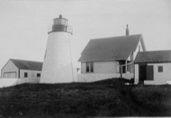
Bird Island Light3.1 miles1987
Ned Point Light3.4 miles1987
Third Meetinghouse3.8 miles1976
Tobey Homestead4.9 miles1986
WITCH (catboat)6.0 miles2008
East Rochester Church and Cemetery Historic District6.1 miles2008

Sources for this property

National Archives recordThe nomination case file for reference 100004738 in Record Group 79.
Wikipedia articleCommunity-written account of this property, licensed CC BY-SA.
Plymouth CountyAll 93 listed properties in this county.

Provenance

  • Listing record. National Park Service National Register of Historic Places, listed-properties dataset, current to 2026-05-22.
  • Map join. Address geocoded through the United States Census geocoder, then tested against the published boundary of every sheet in the USGS Historical Topographic Map Collection.
  • How this page is made. Listing fields come from federal records; map-sheet coverage is a labelled coordinate-to-boundary calculation, not a source-field claim.
  • Wildfire. Short, Karen C. 2022. Spatial wildfire occurrence data for the United States, 1992-2020 [FPA_FOD_20221014]. 6th Edition. Fort Collins, CO: Forest Service Research Data Archive. https://doi.org/10.2737/RDS-2013-0009.6 Collected with United States Government funding and usable without additional permissions or fees.
  • Specimens. Global Biodiversity Information Facility (GBIF), https://www.gbif.org/. Only records licensed CC0 or CC BY are used. Records licensed CC BY-NC are excluded because this site carries advertising. Images are checked individually and any whose licence is non-commercial, no-derivatives or unreadable is refused.
  • Mines and quarries. USGS Mineral Resources Data System (MRDS) https://mrdata.usgs.gov/mrds/ A work of the United States government, no copyright under 17 U.S.C. 105.
  • Storms. NOAA National Centers for Environmental Information, Storm Events Database https://www.ncei.noaa.gov/stormevents/ A work of the United States government, no copyright under 17 U.S.C. 105. Narratives are quoted verbatim from the National Weather Service report and are not edited or summarised.