Photographs from the nomination case file, National Park Service records.
Daniels, Charles A., School
Listed on the National Register of Historic Places in
1987. A historic map-sheet match is not published yet. The record needs a coordinate-quality review before it can be joined to a sheet boundary.
From the record
“Malden Young Men's Christian Association. - In the fall of 1884 this institution first took form and shape in the mind of one young man whose hope it had been for several years, and then by the union of several others, whose desires were as strong as his. As a result, a dozen or more young men who desired an opportunity lor self-culture and improvement in various studies, decided tojoin together in a kind of class, to meet at their houses one evening in each week, and talk over the readings which they should undertake in their leisure hours.”
History of Middlesex County, Massachusetts, with Biographical Sketches of Many of Its Pioneers and Prominent Men (1890). Machine-read text.
one of 1100 National Register listings in Middlesex County · listed in 1987 · category: Building · one of 3 National Historic Landmarks in Middlesex County.
National Register reference number.86003562- the number the National Park Service assigned this property when it was listed, and the key its nomination file is catalogued under at the National Archives.
Malden Medical Improvement Society. - This society Was instituted in 1888, but it was really an outgrowth of the Holmes Medical Club, which w.os started in the city of Maiden some ten years ago, and included the select phy.sicians of Maiden, Medford, Melrose and Stoneham. This society is conducted on the same plan .as the State Medical Society, meeting monthly, when essays and i)apers are read. There is also a presentation of cases. In the winter of 1889, there was given a course of lectures worthy of note. In this society was born the idea of the Maiden City Hospital ; and when Deacon Converse was asked what he could do to help embody the idea, he responded nobly by giving $10,000 in cash, and several -acres of beautiful land. .John L. Sullivan is the present president of the society ; John B. Mahoney, secretary ; Godfrey Ryder, treasurer.
Malden Industrial Aid Society. - This society w:is organized in 1875, the year of the great fire at the R iblier Works. Its object, as stated in the constitution 9 to relieve and prevent destitution, by renderin j; I'rompt, efficient, and judicious aid to the deserving, necessitous poor in our own town ; and to encourage thrift, by endeavoring to cultivate the self-respect and self-reliance of those to whom aid is rendered.
Regional context, not property-specific
evidence. The
federal wildfire occurrence database
lists 87 fires within 5 miles of Daniels, Charles A., School between
2015 and 2020, burning about 112 acres in total. None started naturally. 30 were recorded as arson.
Distance is straight-line from the map coordinates, so a fire counted
here may appear on a neighbouring settlement's page as well.
Reported cause
Fires
Arson/incendiarism
30
Missing data/not specified/undetermined
22
Recreation and ceremony
14
Debris and open burning
11
Smoking
5
Misuse of fire by a minor
2
Equipment and vehicle use
2
Power generation/transmission/distribution
1
The most recent of
them, most recent first, with the day each was reported and the service
that recorded it.
Regional context, not property-specific
evidence. Museums hold 1,488 specimens
collected within 10 miles of Daniels, Charles A., School between 1898 and
1975: 596 Animalia, 493 Plantae, 338 Fungi, 26 Protozoa, 17 Bacteria, 10 Chromista, 8 Unrecorded. 12 distinct Species records are shown.
Collected by ?, A B Seymour, A B. Proper and others. Each is a
physical object with a catalogue
number, and each entry opens the museum's record. This is what was
collected and kept, not a survey of what lives here - nothing can be
concluded from a species being absent.
Regional context, not property-specific
evidence. The federal mineral resources record lists
14 workings within 5 miles of Daniels, Charles A., School: 6 plants, 4 past producers, 3 producers, 1 unknown.
9 still produce. What was taken out: Stone, Crushed/Broken, Lead, Gypsum-Anhydrite, Sand and Gravel, Construction. Distance is straight-line from the
map coordinates, so a quarry counted here may appear on a neighbouring
settlement's page as well.
Regional context, not property-specific
evidence. The National Weather Service names
Malden, the town this property stands in, in 6 storm reports between 2007 and 2021: 4 thunderstorm wind, 2 flood.
No death or injury is recorded in these reports. Each account below is quoted exactly as the forecast office
filed it, from the NOAA Storm Events Database, and each date
opens the federal record of that event.
In Malden, a tree was down on a car on Clinton Street. In Medford, a tree was down on Cushing Street. Also in Medford, a tree was down on Carberry Street. A tree and wires were down and leaning on a house on Governor's Avenue.
No historic map-sheet match is published
for this property yet. That does not mean no map exists. This record needs
a coordinate-quality review before it can be joined to a sheet boundary.
Browse the county's mapped places while that work is
pending.
From the nomination file
4,229 words on record
When this property was proposed for the
National Register, someone wrote the case for it: what the building is,
and why it matters. That document is a federal record in the public domain.
It is quoted below word for word, never summarised. The text was read off the scanned case file by machine, so the
occasional stray character is the recogniser's and the 1970s
typewriter's.
Description of the property
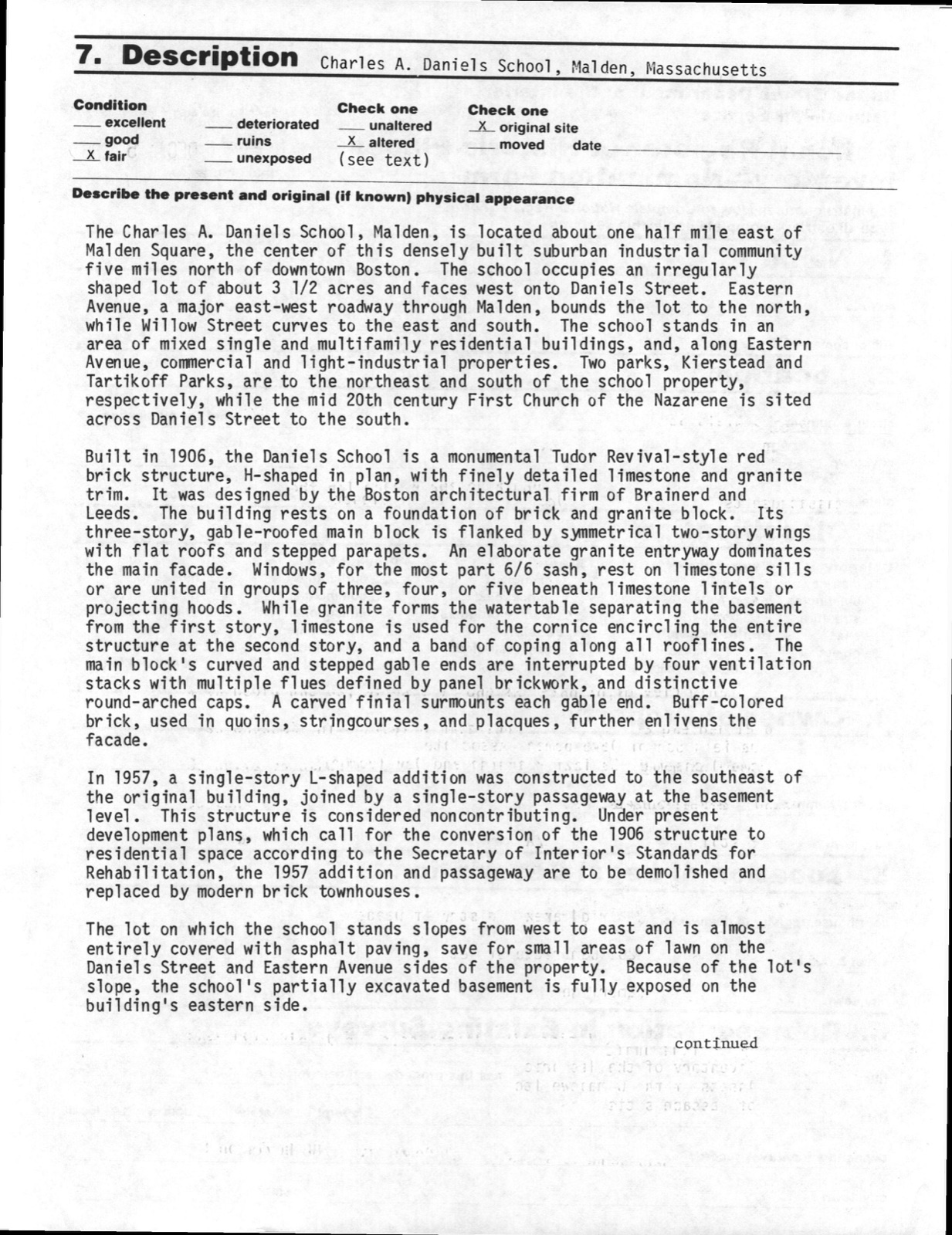
The Charles A. Daniels School, Malden, is located about one half mile east of Malden Square, the center of this densely built suburban industrial community five miles north of downtown Boston. The school occupies an irregularly shaped lot of about 3 1/2 acres and faces west onto Daniels Street. Eastern Avenue, a major east-west roadway through Malden, bounds the lot to the north, while Willow Street curves to the east and south. The school stands in an area of mixed single and multifamily residential buildings, and, along Eastern Avenue, commercial and light-industrial properties. Two parks, Kierstead and Tartikoff Parks, are to the northeast and south of the school property, respectively, while the mid 20th century First Church of the Nazarene is sited across Daniels Street to the south.
Built in 1906, the Daniels School is a monumental Tudor Revival-style red brick structure, H-shaped in plan, with finely detailed limestone and granite trim. It was designed by the Boston architectural firm of Brainerd and Leeds. The building rests on a foundation of brick and granite block. Its three-story, gable-roofed main block is flanked by symmetrical two-story wings with flat roofs and stepped parapets. An elaborate granite entryway dominates the main facade. Windows, for the most part 6/6 sash, rest on limestone sills or are united in groups of three, four, or five beneath limestone lintels or projecting hoods.
While granite the watertable separating the basement from the first story, limestone is used for the cornice encircling the entire structure at the second story, and a band of coping along all rooflines. main block's curved and stepped gable ends are interrupted by four ventilation stacks with multiple flues defined by panel br ickwork, and distinctive round-arched caps. A carved finial surmounts each gable end.
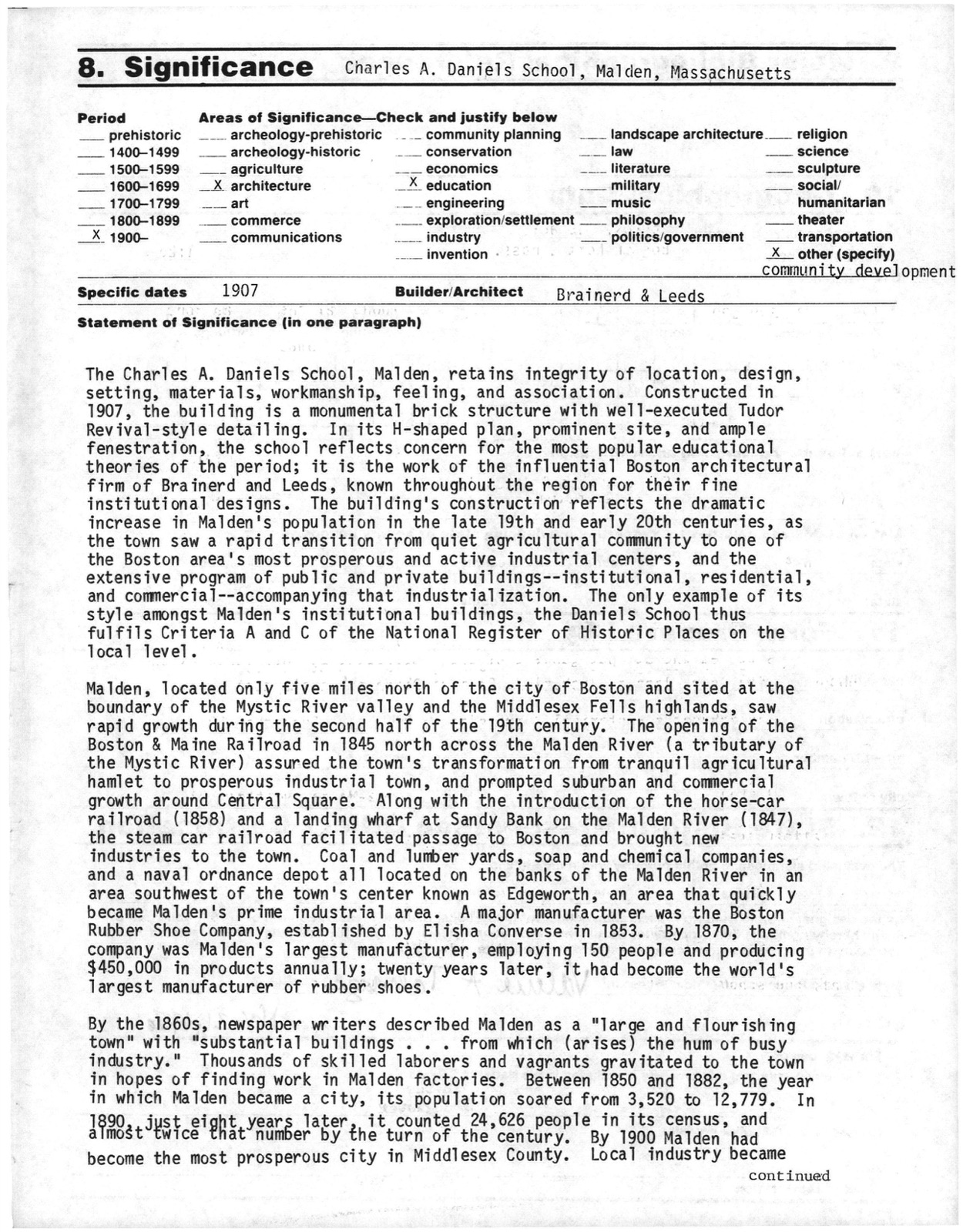
(in one paragraph) Builder/Architect Brainerd & Leeds The Charles A. Daniels School, Malden, retains integrity of location, design, setting, materials, workmanship, feeling, and association. Constructed in 1907, the building is a monumental brick structure with well-executed Tudor Revival-style detailing. In its H-shaped plan, prominent site, and ample fenestration, the school reflects concern for the most popular educationa1 theories of the period; it is the work of the influential Boston architectural firm of Brainerd and Leeds, known throughout the region for their fine institutional designs.
The building's construction reflects the dramatic increase in Malden's population in the late 19th and early 20th centuries, as the town saw a rapid transition from quiet agricultural community to one of the Boston area's most prosperous and active industrial centers, extensive program of public and private buildings--institutional, residential, and commercial--accompanying that industrialization. The only example of its style amongst Malden's institutional buildings, the Daniels School thus fulfils Criteria A and C of the National Register of Historic Places on the local level. Malden, located only five miles north of the city of Boston and sited at the boundary of the MysticRiver valley and the Middlesex Fells highlands, saw rapid growth during the second half of the 19th century.
The opening of the Boston & Maine Railroad in 1845 north across the Malden River (a tributary of the Mystic River) assured the town's transformation from tranquil agricultural hamlet to prosperous industrial town, and prompted suburban and commercial growth around Central Square. Along with the introduction of the horse-car railroad (1858) and a landing wharf at Sandy Bank on the Malden River (1847), the steam car railroad facilitated passage to Boston and brought new industries to the town.
Quoted from the National Register nomination
for reference 86003562, 21 pages, held by the National Archives in Record
Group 79. See the
catalogue record.
Listed places nearby
6 within 8 miles
Other National Register properties close
enough to walk or drive between, ordered by distance from this one. Both
positions come from the same geocoding pass that matched these properties
to their map sheets.
Listing record. National Park Service National Register of Historic Places, listed-properties dataset, current to 2026-05-22.
Map join. Address geocoded through the United States Census geocoder, then tested against the published boundary of every sheet in the USGS Historical Topographic Map Collection.
How this page is made. Listing fields come from federal records; map-sheet coverage is a labelled coordinate-to-boundary calculation, not a source-field claim.
Wildfire. Short, Karen C. 2022. Spatial wildfire occurrence data for the United States, 1992-2020 [FPA_FOD_20221014]. 6th Edition. Fort Collins, CO: Forest Service Research Data Archive. https://doi.org/10.2737/RDS-2013-0009.6 Collected with United States Government funding and usable without additional permissions or fees.
Specimens. Global Biodiversity Information Facility (GBIF), https://www.gbif.org/. Only records licensed CC0 or CC BY are used. Records licensed CC BY-NC are excluded because this site carries advertising. Images are checked individually and any whose licence is non-commercial, no-derivatives or unreadable is refused.
Mines and quarries. USGS Mineral Resources Data System (MRDS) https://mrdata.usgs.gov/mrds/ A work of the United States government, no copyright under 17 U.S.C. 105.
Storms. NOAA National Centers for Environmental Information, Storm Events Database https://www.ncei.noaa.gov/stormevents/ A work of the United States government, no copyright under 17 U.S.C. 105. Narratives are quoted verbatim from the National Weather Service report and are not edited or summarised.
 Block
Block