Listed on the National Register of Historic Places in
1987. A historic map-sheet match is not published yet. The record needs a coordinate-quality review before it can be joined to a sheet boundary.
From the record
one of 20 National Register listings in Pickaway County · listed in 1987 · category: Building.
National Register reference number.87000634- the number the National Park Service assigned this property when it was listed, and the key its nomination file is catalogued under at the National Archives.
Specimens collected near this property
12 of 872 shown
Regional context, not property-specific
evidence. Museums hold 872 specimens
collected within 10 miles of Scioto Township District No. 2 Schoolhouse between 1894 and
1975: 846 Animalia, 25 Plantae, 1 Fungi. 12 distinct Species records are shown.
Collected by Abbott, R; and others, Abbott, R; vonder Heyden, Jonna, B.R. Bales and others. Each is a
physical object with a catalogue
number, and each entry opens the museum's record. This is what was
collected and kept, not a survey of what lives here - nothing can be
concluded from a species being absent.
Regional context, not property-specific
evidence. The National Weather Service names
Orient, the town this property stands in, in 13 storm reports between 1994 and 2022: 8 thunderstorm wind, 3 flood, 1 hail, 1 tornado.
No death or injury is recorded in these reports. Each account below is quoted exactly as the forecast office
filed it, from the NOAA Storm Events Database, and each date
opens the federal record of that event.
A tornado briefly touched down in extreme northwest Pickaway County. The damage path extended along a short length of Carson Road, just west of Interstate 71. A barn made of wood and cinder blocks was completely destroyed, with the cinder blocks being carried 200 to 300 yards away. Several pieces of wood were strewn onto neighboring properties, with some pieces impaled into the ground or asphalt. A few homes had significant roof damage and windows blown out. Large trees were snapped or uprooted along the damage path. The damage was mainly F1, with some isolated pockets of low end F2 damage up to 120 mph.
Ten roads were flooded and closed across the northern part of the county, including State Route 752 and Hagerty Road in Ashville, Scioto Darby Road, Dennis Road, London Road and Pontius Road.
No historic map-sheet match is published
for this property yet. That does not mean no map exists. This record needs
a coordinate-quality review before it can be joined to a sheet boundary.
Browse the county's mapped places while that work is
pending.
From the nomination file
2,532 words on record
When this property was proposed for the
National Register, someone wrote the case for it: what the building is,
and why it matters. That document is a federal record in the public domain.
It is quoted below word for word, never summarised. The text was read off the scanned case file by machine, so the
occasional stray character is the recogniser's and the 1970s
typewriter's.
Description of the property
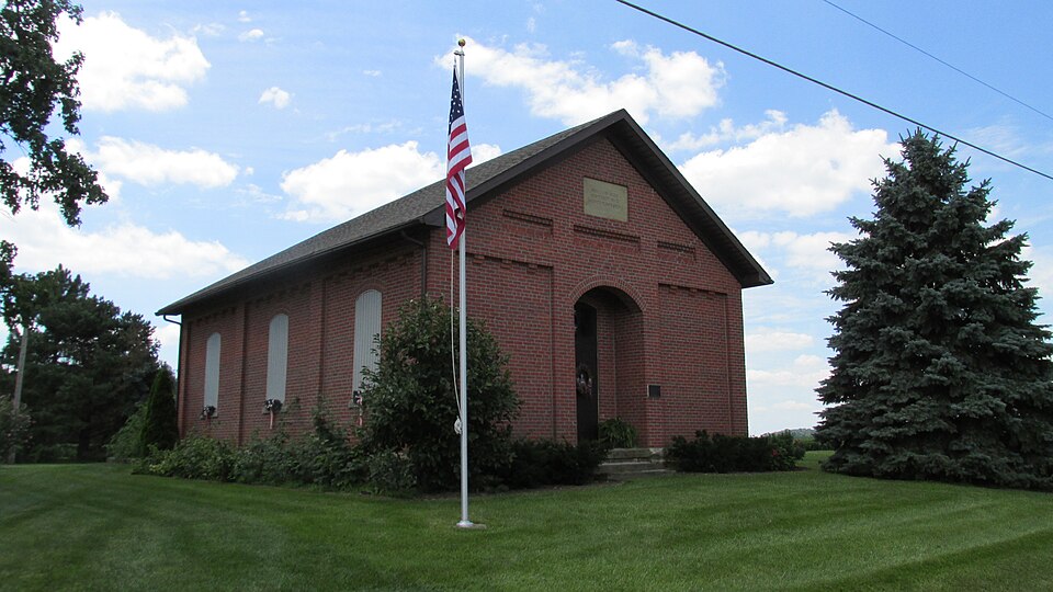
Formerly, the school had a belltower and central chimney.In 1979 the roof was replaced have been for at least 47 years.In the gable end of the facade is a sandstone plaque The front entry is a single paneled door entry centered and recessed in the facade. Areas of Significance - Check and justify below -archeology-prehistoric - archeology-historic other (specify) best preserved one-room schoolhouse in Scioto Township and the only schoolhouse of in the township and the county, the schools were most often brick, but the exterior walls were plain and flush.
Elements common to Pickaway County schoolhouses includes the rectangular plan, the gable roof with projecting eaves, the three double hung: windows with flat, round or segmental arches on each side wall, and either one single door centered in the facade or two separate doors on each side of the facade. This In addition, the interior plan of this schoolhouse is intact with the two cloakrooms window and closet trim, wainscot and chairrail, and wood floor are also extant, although used for residences or are being used for hay storage, livestock shelter etc. and Like most areas of the state, during the late 19th century there were rural district population and the school population of Pickaway County, many schools were constructed. the county, although the survey is not comprehensive.
were erected, including the first high school which was constructed in Commercial Point districts were defined. By 1906, all 13 schools were brick, including a 2-room school and District #7 is a later version with a hip roof (post 1906). Board of Education for a schoolhouse lot in 1867/1888 (two parts).
(in one paragraph) schoolhouses in the county. in 1895.In 1896 The Scioto Township Board of Education was organized and 13 school military #6 has been altered and is used for livestock, District #9 is abandoned and overgrown, Scioto Township District No.2was defined by 1855.It had as many pupils as 67 in 1876 science School was being taught as early as 18l4 in Scioto Township.By 1855,when the Pickaway and as few as 25 in 1910.The 3/4 acre parcel being nominated was first deeded to the ---politics/government -art landscape architecture X architecture County system was 42 square miles.
Twenty one-room schoolhouses have been surveyed in County Board of Education records begin, nine school districts had been defined in 1600-1699 schoolhouses scattered throughout the county.Because of the sparseness of the total county's history.Controlled by separate boards of education, each had an immense The Scioto Township District No.2 Schoolhouse is significant under Criteria C as the Collectively they represent the important role provided by "country schools" in the in fair condition.
Many of the extant schoolhouses in the county are being adaptively schoolbuilding conforms to the type with its segmental arched openings and single aside the entrance on the north wall.Interior details such as the 1886 the system had expanded to twelve schools.Between 1868 and 1907,eight schools Scioto Township.In 1867,there were frame and 2log schools in use.By religion 9.
Quoted from the National Register nomination
for reference 87000634, 27 pages, held by the National Archives in Record
Group 79. See the
catalogue record.
Listing record. National Park Service National Register of Historic Places, listed-properties dataset, current to 2026-05-22.
Map join. Address geocoded through the United States Census geocoder, then tested against the published boundary of every sheet in the USGS Historical Topographic Map Collection.
How this page is made. Listing fields come from federal records; map-sheet coverage is a labelled coordinate-to-boundary calculation, not a source-field claim.
Specimens. Global Biodiversity Information Facility (GBIF), https://www.gbif.org/. Only records licensed CC0 or CC BY are used. Records licensed CC BY-NC are excluded because this site carries advertising. Images are checked individually and any whose licence is non-commercial, no-derivatives or unreadable is refused.
Storms. NOAA National Centers for Environmental Information, Storm Events Database https://www.ncei.noaa.gov/stormevents/ A work of the United States government, no copyright under 17 U.S.C. 105. Narratives are quoted verbatim from the National Weather Service report and are not edited or summarised.
 Block
Block