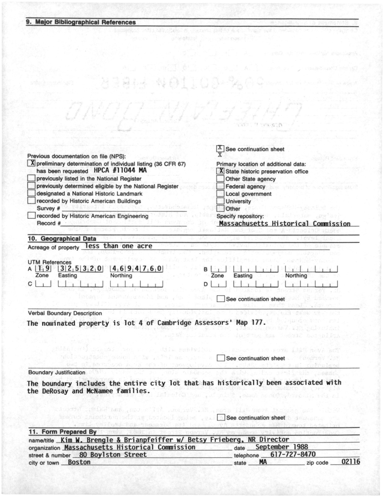
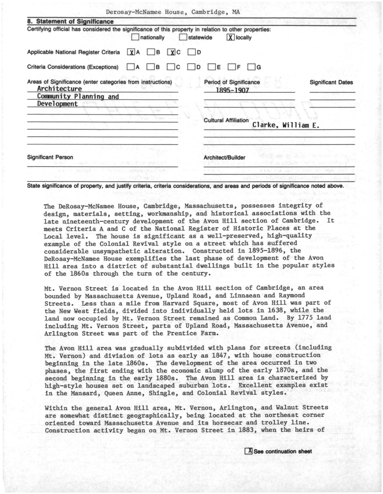
Photographs from the nomination case file, National Park Service records.
DeRosay--McNamee House
Listed on the National Register of Historic Places in
1990. A historic map-sheet match is not published yet. The record needs a coordinate-quality review before it can be joined to a sheet boundary.
From the record
“The forces occupying the hills of Somenille constituted the left wing of the army besieging Boston. The first of the line of fortifications were earthworks in the vicinity of Everett Street.”
History of Middlesex County, Massachusetts (1880). Machine-read text.
one of 1100 National Register listings in Middlesex County · listed in 1990 · category: Building · one of 3 National Historic Landmarks in Middlesex County.
National Register reference number.90000142- the number the National Park Service assigned this property when it was listed, and the key its nomination file is catalogued under at the National Archives.
Mr. John Woolu'ich, " Indian trader," lived a mile and a half without the neck, on the Cambridge Eoad, near Strawberry Hill, as early as 1630. He was a representative to tlie General Court in 1634'. John Libby and William Ayre were also early settlers in the same neighborhood.
The early inhabitants of Somerville were mostly farmers, and many of them large producers of milk. A few were engaged in alewife fishery at the proper seasons. Brickmaking M-as a branch of industry Oldened after the Eevolution, and has been since continued. At the time of the Eevolution the population of the Somerville territory could not have been more than two hundred and fifty. The houses numbered a few more than thirty, and were principally on the Cambridge, Winter Hill, and Milk Eow roads.
Regional context, not property-specific
evidence. The
federal wildfire occurrence database
lists 81 fires within 5 miles of DeRosay--McNamee House between
2015 and 2020, burning about 109 acres in total. None started naturally. 29 were recorded as arson.
Distance is straight-line from the map coordinates, so a fire counted
here may appear on a neighbouring settlement's page as well.
Reported cause
Fires
Arson/incendiarism
29
Missing data/not specified/undetermined
21
Recreation and ceremony
12
Debris and open burning
11
Smoking
6
Equipment and vehicle use
1
Misuse of fire by a minor
1
The most recent of
them, most recent first, with the day each was reported and the service
that recorded it.
Regional context, not property-specific
evidence. Museums hold 1,894 specimens
collected within 10 miles of DeRosay--McNamee House between 1898 and
1975: 836 Animalia, 580 Plantae, 414 Fungi, 27 Protozoa, 17 Bacteria, 12 Chromista, 8 Unrecorded. 12 distinct Species records are shown.
Collected by ?, A B Seymour, A B. Proper and others. Each is a
physical object with a catalogue
number, and each entry opens the museum's record. This is what was
collected and kept, not a survey of what lives here - nothing can be
concluded from a species being absent.
Regional context, not property-specific
evidence. The federal mineral resources record lists
11 workings within 5 miles of DeRosay--McNamee House: 9 plants, 2 past producers.
9 still produce. What was taken out: Iron, Lead, Gypsum-Anhydrite, Sand and Gravel, Construction. Distance is straight-line from the
map coordinates, so a quarry counted here may appear on a neighbouring
settlement's page as well.
Regional context, not property-specific
evidence. The National Weather Service names
Cambridge, the town this property stands in, in 16 storm reports between 2006 and 2023: 7 thunderstorm wind, 3 flood, 3 flash flood, 2 lightning.
No death or injury is recorded in these reports. Each account below is quoted exactly as the forecast office
filed it, from the NOAA Storm Events Database, and each date
opens the federal record of that event.
No historic map-sheet match is published
for this property yet. That does not mean no map exists. This record needs
a coordinate-quality review before it can be joined to a sheet boundary.
Browse the county's mapped places while that work is
pending.
From the nomination file
4,251 words on record
When this property was proposed for the
National Register, someone wrote the case for it: what the building is,
and why it matters. That document is a federal record in the public domain.
It is quoted below word for word, never summarised. The text was read off the scanned case file by machine, so the
occasional stray character is the recogniser's and the 1970s
typewriter's.
Statement of significance
Certifying official has considered the significance of this property in relation to other properties: nationally statewide X locally Applicable National Register Criteria XA B D Criteria Considerations (Exceptions) B C D E G Areas of Significance (enter categories from instructions) Architecture Community Planning and Development Period of Significance 1895-1907 Significant Dates Cultural Affiliation Clarke, William E. Significant Person Architect/Builder State significance of property, and justify criteria, criteria considerations, and areas and periods of significance noted above.
The DeRosay-McNamee House, Cambridge, Massachusetts, possesses integrity of design, materials, setting, workmanship, and historical associations with the late nineteenth-century development of the Avon Hill section of Cambridge. It meets Criteria A and C of the National Register of Historic Places at the Local level. The house is significant as a well-preserved, high-quality example of the Colonial Revival style on a street which has suffered considerable unsympathetic alteration. Constructed in 1895-1896, the DeRosay-McNamee House exemplifies the last phase of development of the Avon Hill area into a district of substantial dwellings built in the popular styles of the 1860s through the turn of the century. Mt.
Vernon Street is located in the Avon Hill section of Cambridge, an area bounded by Massachusetts Avenue, Upland Road, and Linnaean and Raymond Streets. Less than a mile from Harvard Square, most of Avon Hill was part of the New West fields, divided into individually held lots in 1638, while the land now occupied by Mt. Vernon Street remained as Common Land. By 1775 land including Mt. Vernon Street, parts of Upland Road, Massachusetts Avenue, and Arlington Street was part of the Prentice Farm. The Avon Hil1 area was gradually subdivided with plans for streets (including Mt. Vernon) and division of lots as early as 1847, with house construction beginning in the late 1860s.
Quoted from the National Register nomination
for reference 90000142, 19 pages, held by the National Archives in Record
Group 79. See the
catalogue record.
Listed places nearby
6 within 8 miles
Other National Register properties close
enough to walk or drive between, ordered by distance from this one. Both
positions come from the same geocoding pass that matched these properties
to their map sheets.
Listing record. National Park Service National Register of Historic Places, listed-properties dataset, current to 2026-05-22.
Map join. Address geocoded through the United States Census geocoder, then tested against the published boundary of every sheet in the USGS Historical Topographic Map Collection.
How this page is made. Listing fields come from federal records; map-sheet coverage is a labelled coordinate-to-boundary calculation, not a source-field claim.
Wildfire. Short, Karen C. 2022. Spatial wildfire occurrence data for the United States, 1992-2020 [FPA_FOD_20221014]. 6th Edition. Fort Collins, CO: Forest Service Research Data Archive. https://doi.org/10.2737/RDS-2013-0009.6 Collected with United States Government funding and usable without additional permissions or fees.
Specimens. Global Biodiversity Information Facility (GBIF), https://www.gbif.org/. Only records licensed CC0 or CC BY are used. Records licensed CC BY-NC are excluded because this site carries advertising. Images are checked individually and any whose licence is non-commercial, no-derivatives or unreadable is refused.
Mines and quarries. USGS Mineral Resources Data System (MRDS) https://mrdata.usgs.gov/mrds/ A work of the United States government, no copyright under 17 U.S.C. 105.
Storms. NOAA National Centers for Environmental Information, Storm Events Database https://www.ncei.noaa.gov/stormevents/ A work of the United States government, no copyright under 17 U.S.C. 105. Narratives are quoted verbatim from the National Weather Service report and are not edited or summarised.
 Block
Block