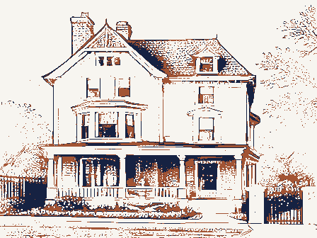
Listed on the National Register of Historic Places in
1990. A historic map-sheet match is not published yet. The record needs a coordinate-quality review before it can be joined to a sheet boundary.
From the record
“We now return to the civil history of the town. Adams, in his historical discourse, alluding to the early days of the colony, remarks : " We can better understand the changes which a century and a half have wrought, and can better enter into the experience and life of the good men who laid the foundations for us, if we glance at the condition of the country in 1728.”
History of Middlesex County, Massachusetts, with Biographical Sketches of Many of Its Pioneers and Prominent Men (1890). Machine-read text.
one of 1100 National Register listings in Middlesex County · listed in 1990 · category: Building · one of 3 National Historic Landmarks in Middlesex County.
Also known as. First Period Buildings of Eastern Massachusetts TR
Township. Holliston town
National Register reference number.90000171- the number the National Park Service assigned this property when it was listed, and the key its nomination file is catalogued under at the National Archives.
The town of Holliston reaches to the southern point of Middlesex County, and forms a large part of its boundary in that direction. The boundary line separates it from Medway and Millis, in the county of Norfolk, and from a portion of Milford, in the county of Worcester. It is a daughter of Sherborn, having been formed entirely from that ancient town. The history of Sherborn is therefore the history of Holliston until the date of incorporation of the latter town, in 1724.
Grants of the land now included in this township were made by the General Court, as early as 1659, to Major Eleazer Lusher, of Dedhara, and to Dean Winthrop, son of Governor John Winthrop; and also, from 1664 to 1674, to Lieutenant Joshua Fisher, of Dedham, to John Parker and one Hopper. Lusher's grant of two hundred and fifty acres comprised the present central pari of Holliston, and twelve acres of meadow "lying on the brook Wennakeening" (Bogistow Brook); and Winthrop's grant of six hundred acres or more abutted upon Medfield line in one direction and upon a pond (Winthrop's) in the other. Major Lusher sold his grant to Lieutenant Henry Adams, of Medfield, in 1660; and after the death of Lieutenant Adams it was bought by Hon. William Brown, of Salem, and afterwards came into the possession of his son. Colonel Samuel Brown, and Judge Samuel Sewall. Lieutenant Adams took immediate possession and is said to have mowed the meadows the same year. He sent cattle here and some of his sons resided here, especially Jasper, who seems to have had the management of the land and gave his name to ".lasper's hill," now Mt. Mollis, from whiidi, bv signal fires, he communicated with his father in Medfield. He lived here, unmarried, for a period of about fourteen years until driven off by the Indians under King Philip in 1676.
Regional context, not property-specific
evidence. The
federal wildfire occurrence database
lists 122 fires within 5 miles of Bullard, Isaac, House between
2016 and 2020, burning about 50 acres in total. 3 started naturally. 4 were recorded as arson.
Distance is straight-line from the map coordinates, so a fire counted
here may appear on a neighbouring settlement's page as well.
Reported cause
Fires
Debris and open burning
57
Missing data/not specified/undetermined
27
Recreation and ceremony
12
Power generation/transmission/distribution
7
Arson/incendiarism
4
Misuse of fire by a minor
4
Natural
3
Railroad operations and maintenance
3
Fireworks
2
Equipment and vehicle use
2
Other causes
1
The most recent of
them, most recent first, with the day each was reported and the service
that recorded it.
Regional context, not property-specific
evidence. Museums hold 990 specimens
collected within 10 miles of Bullard, Isaac, House between 1898 and
1975: 773 Animalia, 165 Plantae, 50 Fungi, 2 Chromista. 12 distinct Species records are shown.
Collected by A. B. Seymour, A. L. Bosworth, A. M. Ottley and others. Each is a
physical object with a catalogue
number, and each entry opens the museum's record. This is what was
collected and kept, not a survey of what lives here - nothing can be
concluded from a species being absent.
Regional context, not property-specific
evidence. The federal mineral resources record lists
25 workings within 5 miles of Bullard, Isaac, House: 19 past producers, 3 producers, 3 plants.
6 still produce. What was taken out: Sand and Gravel, Construction, Granite, Stone, Crushed/Broken, Iron. Distance is straight-line from the
map coordinates, so a quarry counted here may appear on a neighbouring
settlement's page as well.
Regional context, not property-specific
evidence. The National Weather Service names
Holliston, the town this property stands in, in 13 storm reports between 1994 and 2022: 8 thunderstorm wind, 3 hail, 2 flood.
No death or injury is recorded in these reports. Each account below is quoted exactly as the forecast office
filed it, from the NOAA Storm Events Database, and each date
opens the federal record of that event.
Each of the seven gaged mainstem rivers in Middlesex County rose above flood stage, the Nashua River at East Pepperell, Shawsheen River at Wilmington, and the Assabet River at Maynard all reached major flood. The Concord River at Lowell and the Shawsheen River at Wilmington set record flood stages.||In addition, several small streams went into flood, including the Charles River at Waltham and Cambridge, and the Aberjona River at Winchester. Damage from this river flooding, along with poor drainage and street flooding, resulted in a federal disaster declaration for this and six other counties in Massachusetts. ||Numerous basements flooded in Weston, Newton, Natick, Watertown, Winchester, Billerica, Tewksbury, Lowell, Pepperell, and Concord. In addition, many streets were closed due to flooding in Waltham, Burlington, Wayland, Chelmsford, Lexington, Watertown, Acton, Arlington, North Reading, Sudbury, Winchester, Shirley, Natick, Holliston, Woburn, Wilmington, Framingham, Billerica, Groton, and Pepperell, including the interchange at Route 128 and Winter Street and several lane restrictions on Interstate 95 in Waltham. More than 700 homes and 25 city buildings in Newton sustained flood damage, including destroyed city files in the city hall basement.||Several apartments (about 20 people) in the 100 block of Linden Street in Waltham were evacuated due to flooding. Residents at the Gardencrest Apartments and a few at the Waverly Oaks Road apartments in Waltham were also evacuated. Roughly 150 people were evacuated from a public housing complex in Melrose. Tenants from 136 apartments on Beaver Street in Framingham were evacuated. While no evacuation orders were reported, at least one Billerica resident had to be rescued from their home by boat. In Winchester, homes on Brookside Avenue were evacuated.||Forty feet of rail bed was washed out between Chestnut Hill and Newton after a twelve foot deep, fifty foot diameter sinkhole developed beneath the MBTA green line tracks in Newton. Material washed out of the railbed travelled downhill landing in and around an office building on Glen Road. This resulted in 18 inches of mud and rocks in the first floor of the building and drifts up to 6 feet outside the building. Commuters were bused between the Newton Highlands and Reservoir stations. The Wilmington MBTA station was also closed due to flooding. A sinkhole on Church Street in Holliston resulted in the closing of that street. Emerson Hospital in Concord had water flooding its stairwells.||A neighborhood in Wilmington was flooded with four feet of water, four people were rescued by boat, 12 to 14 others were evacuated. A person was rescued from an apartment building on Pratt Avenue in Lowell that was flooded with four feet of water.||Collections at the Reading Public, Winchester Public, and Somerville Public Libraries, the Charles River Museum of Industry, and public records at the City of Newton were damaged by floodwaters. The Public Safety Complex that houses both the Fire and Police Departments in Wayland was flooded with nearly three feet of water, resulting in a power loss and damage to the boiler units and HVAC units. The complex ran on generator power for several days and without heat and air conditioning for several weeks while the HVAC units were being replaced. In North Reading, several schools and the Parks and Rec building at Ipswich River Park sustained water damage. Water overflowing the Moody Street Dam in Waltham flooded a retirement home and a museum.
Numerous trees and wires were downed from Metrowest to the immediate Boston area, including Holliston, Framingham, Natick, Newton, Waltham, Wakefield, Watertown, Somerville, and Malden.
No historic map-sheet match is published
for this property yet. That does not mean no map exists. This record needs
a coordinate-quality review before it can be joined to a sheet boundary.
Browse the county's mapped places while that work is
pending.
From the nomination file
1,217 words on record
When this property was proposed for the
National Register, someone wrote the case for it: what the building is,
and why it matters. That document is a federal record in the public domain.
It is reproduced in full on its own page, word for word and never summarised. The text was read off the scanned case file by machine, so the
occasional stray character is the recogniser's and the 1970s
typewriter's.
Quoted from the National Register nomination
for reference 90000171, 11 pages, held by the National Archives in Record
Group 79. See the
catalogue record.
Listed places nearby
6 within 8 miles
Other National Register properties close
enough to walk or drive between, ordered by distance from this one. Both
positions come from the same geocoding pass that matched these properties
to their map sheets.
Listing record. National Park Service National Register of Historic Places, listed-properties dataset, current to 2026-05-22.
Map join. Address geocoded through the United States Census geocoder, then tested against the published boundary of every sheet in the USGS Historical Topographic Map Collection.
How this page is made. Listing fields come from federal records; map-sheet coverage is a labelled coordinate-to-boundary calculation, not a source-field claim.
Wildfire. Short, Karen C. 2022. Spatial wildfire occurrence data for the United States, 1992-2020 [FPA_FOD_20221014]. 6th Edition. Fort Collins, CO: Forest Service Research Data Archive. https://doi.org/10.2737/RDS-2013-0009.6 Collected with United States Government funding and usable without additional permissions or fees.
Specimens. Global Biodiversity Information Facility (GBIF), https://www.gbif.org/. Only records licensed CC0 or CC BY are used. Records licensed CC BY-NC are excluded because this site carries advertising. Images are checked individually and any whose licence is non-commercial, no-derivatives or unreadable is refused.
Mines and quarries. USGS Mineral Resources Data System (MRDS) https://mrdata.usgs.gov/mrds/ A work of the United States government, no copyright under 17 U.S.C. 105.
Storms. NOAA National Centers for Environmental Information, Storm Events Database https://www.ncei.noaa.gov/stormevents/ A work of the United States government, no copyright under 17 U.S.C. 105. Narratives are quoted verbatim from the National Weather Service report and are not edited or summarised.
 Block
Block