BlockBefore
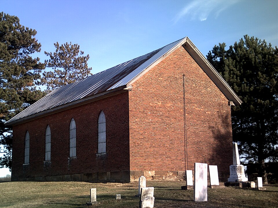
Photograph of Kilgore Union Presbyterian Church
Photograph by Roseohioresident, Public domain. Via Wikimedia Commons.

Kilgore Union Presbyterian Church

Listed on the National Register of Historic Places in 1995. A historic map-sheet match is not published yet. The record needs a coordinate-quality review before it can be joined to a sheet boundary.

From the record

“Kilgore Union Presbyterian Church is a historic Presbyterian church building in Kilgore, Ohio.”

Wikipedia article Kilgore Union Presbyterian Church, CC BY-SA 4.0.

one of 11 National Register listings in Carroll County · listed in 1995 · category: Building.

Sources: the Wikipedia article · the case file at the National Archives · the National Register database, National Park Service

The listing

  • What is counted as historic. The nomination lists 1 building as contributing to the listing.
  • Address. 7219 Germano Rd. SE, Carrollton, 43903
  • When was it listed? 1995-03-15
  • Category. building
  • Township. Loudon township
  • National Register reference number. 95000166 - the number the National Park Service assigned this property when it was listed, and the key its nomination file is catalogued under at the National Archives.

Fires near this property

14 since 2003

Regional context, not property-specific evidence. The federal wildfire occurrence database lists 14 fires within 5 miles of Kilgore Union Presbyterian Church between 2003 and 2018, burning about 53 acres in total. None started naturally. None was recorded as arson. Distance is straight-line from the map coordinates, so a fire counted here may appear on a neighbouring settlement's page as well.

Reported cause Fires
Debris and open burning10
Missing data/not specified/undetermined2
Power generation/transmission/distribution1
Equipment and vehicle use1

The most recent of them, most recent first, with the day each was reported and the service that recorded it.

DateCause SizeReported by Name on the report
7 May 2018Power generation/transmission/distribution1.0 acresOhio Department of Natural Resources12705
23 April 2013Debris and open burning1.0 acresOhio Department of Natural Resourcesnot named
23 April 2013Missing data/not specified/undeterminedunder an acreOhio Department of Natural Resourcesnot named
21 April 2018Missing data/not specified/undetermined12 acresOhio Department of Natural Resources12909
12 April 2015Equipment and vehicle use12 acresOhio Department of Natural Resources820
12 April 2003Debris and open burning1.0 acresOhio Department of Natural Resourcesnot named
1 April 2014Debris and open burning7.0 acresOhio Department of Natural Resourcesnot named
1 April 2014Debris and open burning8.0 acresOhio Department of Natural Resourcesnot named

Every fire recorded in Carroll County

Specimens collected near this property

12 of 219 shown

Regional context, not property-specific evidence. Museums hold 219 specimens collected within 10 miles of Kilgore Union Presbyterian Church between 1896 and 1975: 179 Animalia, 36 Plantae, 4 Fungi. 12 distinct Species records are shown. Collected by A.W. Cusick, Allen, E. J., Ash, G. (Gail), Buchanan, F. W. (Forrest W.) & Trautman, M. B. (Milton Bernard) and others. Each is a physical object with a catalogue number, and each entry opens the museum's record. This is what was collected and kept, not a survey of what lives here - nothing can be concluded from a species being absent.

Image SpeciesYear Collected by Where, as recorded
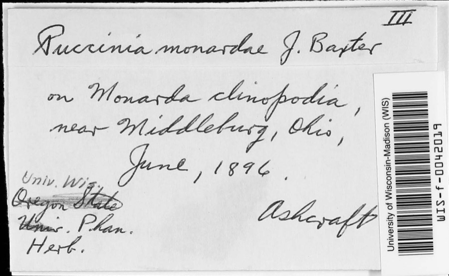
Specimen of Puccinia monardae J.W.BaxterPuccinia monardae J.W.Baxter1896AshcraftNear Middleburg
A photograph of the species Amblema plicata, not of this specimenAmblema plicata (Say, 1817)1905Ortmann, Arnold ENew Hagerstown
A photograph of the species Pyganodon grandis, not of this specimenPyganodon grandis (Say, 1829)1905Ortmann, Arnold ENew Hagerstown
A photograph of the species Xylaria cubensis, not of this specimenXylaria cubensis (Mont.) Fr.1924Leonard E. C.Indian Lake
A photograph of the species Desmognathus fuscus, not of this specimenDesmognathus fuscus fuscus (Green, 1818)1930Walker, C. F. (Charles F.)Harlem Springs, Lee Twp., Carroll Co., Ohio
A photograph of the species Eurycea bislineata, not of this specimenEurycea bislineata (Green, 1818)1930Walker, C. F. (Charles F.)Harlem Springs, Lee Twp., Carroll Co., Ohio
A photograph of the species Eurycea longicauda, not of this specimenEurycea longicauda longicauda (Green, 1818)1930Walker, C. F. (Charles F.)Harlem Springs, Lee Twp., Carroll Co., Ohio
A photograph of the species Hemidactylium scutatum, not of this specimenHemidactylium scutatum (Temminck, 1838)1930Walker, C. F. (Charles F.)Harlem Springs, Carroll Co., Ohio
A photograph of the species Plethodon glutinosus, not of this specimenPlethodon glutinosus (Green, 1818)1930Walker, C. F. (Charles F.)Harlem Springs, Lee Twp., Carroll Co., Ohio
A photograph of the species Plethodon richmondi, not of this specimenPlethodon richmondi Netting & Mittleman, 19381930Walker, C. F. (Charles F.)Harlem Springs, Lee Twp., Carroll Co., Ohio
Pseudacris brachyphona (Cope, 1889)1930Walker, C. F. (Charles F.)Harlem Springs, Lee Twp., Carroll Co., Ohio
A photograph of the species Pseudacris crucifer, not of this specimenPseudacris crucifer (Wied-Neuwied, 1838)1930Walker, C. F. (Charles F.)Harlem Springs, Lee Twp., Carroll Co., Ohio

All 219 specimens within 10 miles, at the Global Biodiversity Information Facility.

Storms near this property

57 since 1994

Regional context, not property-specific evidence. The National Weather Service names Carrollton, the town this property stands in, in 57 storm reports between 1994 and 2026: 38 thunderstorm wind, 8 hail, 5 flash flood, 2 flood. The reports record 6 injuries. Each account below is quoted exactly as the forecast office filed it, from the NOAA Storm Events Database, and each date opens the federal record of that event.

WhenEvent Place namedHarm What the report says
September 2006LightningCarrollton6 hurtLightning injured 6 people at a soccer game as they sat in lawn chairs. Some were holding umbrellas. Lightning struck the umbrella of a 37-year old man. He was critically injured. Three other adults and 2 children were slightly injured.
June 2009Thunderstorm WindCarrollton$75,000Law enforcement reported trees and power lines down in Carrollton.
May 2019Tornado (EF1)Carrollton$60,000The National Weather Service in Pittsburgh has confirmed an EF1 tornado in the city of Carrollton on Saturday afternoon May 25th.|||The tornado touched down in a wooded area off of Crest |Street then lifted briefly across Canton Road NW before tearing the top of a |large hardwood tree behind the McDonald's. The worst of the damage |was an overturned single wide mobile home. There were shingles off |several other mobile homes within the mobile home park. A metal shed |was also destroyed. Intermittent touchdowns continued causing minor |damage and shingles off the roofs of a few homes along N Lisbon |Street. Numerous hardwood trees behind the aforementioned street |were snapped mid way up in a ravine.
June 2010FloodCarrollton$50,000County officials reported Canton Road and Alamo road flooded due to heavy rain.
June 2008Thunderstorm WindCarrollton$50,000Law enforcement reported multiple trees down in Carrollton.
August 2007Thunderstorm WindCarrollton$50,000Emergency management reported trees down in Carrollton.
March 2026Thunderstorm WindCarrollton$49,000Several power poles snapped and trees uprooted in Carrollton including concentrated damage on East Main Street.
August 2007Thunderstorm WindCarrollton$35,000Emergency management reported trees down in Carrollton.
July 2013Thunderstorm WindCarrollton$30,000The public reported trees down.
July 2013Thunderstorm WindCarrollton$25,000Emergency management reported a tree fell on a car.
March 2011FloodCarrollton$25,000Emergency management reported several roads still closed due to stnading waters as well as from creeks still out of their banks.
August 2010Thunderstorm WindCarrollton$25,000Law enforcement reported trees down in Carrollton.
August 2007Flash FloodCarrollton$25,000Law enforcement reported a creek flooding SR 49 and SR 43 between Carrollton and Malvern.
November 2013Thunderstorm WindCarrollton$15,000Law enforcement reported large tree branches down.
June 2020Thunderstorm WindCarrollton$10,000Carroll County Dispatch reported that multiple trees were blown down in the county.
July 2011Thunderstorm WindCarrollton$10,000Law enforcement reports trees and power lines down countywide.
May 2007Thunderstorm WindCarrollton$10,000Emergency management reported numerous trees and power lines down throughout Carrollton.
November 2005Thunderstorm WindCarrollton$10,000Trees and power lines blown down. [CORRECTED TIME]
May 2002Thunderstorm WindCarrollton$10,000Thunderstorm winds downed numerous trees and power lines.
January 1996Flash FloodCarrollton$10,000no account filed
August 2017Thunderstorm WindCarrollton$8,000Emergency manager reported numerous trees uprooted and ripped off along Fresno Road, Fisherman Road, and Bacon Road.
July 2022Thunderstorm WindCarrollton$5,000On State Route 9, two trees were blown down near town.
May 2015Thunderstorm WindCarrollton$5,000Local 911 center reported numerous trees down in and around Carrollton.
June 2014Thunderstorm WindCarrollton$5,000Law enforcement reported trees down.
June 2006Thunderstorm WindCarrollton$5,00065 mph gust (57 kt) reported by skywarn spotter. Trees blown down along SR 39.
June 2002Thunderstorm WindCarrollton$5,000Thunderstorm winds downed several trees and power lines.
July 1994Thunderstorm WindCarrollton$5,000Trees and limbs were downed, some on power lines.
June 2025Thunderstorm WindCarrollton$4,000A number of trees were reported down in the town of Carrolton, OH.
June 2000Thunderstorm WindCarrollton$3,000Thunderstorm winds downed a few trees into power lines.
May 1998Thunderstorm WindCarrollton$3,000Trees and power lines were downed by thunderstorm winds.
January 2017Thunderstorm WindCarrollton$2,000State official reported trees down.
July 2003Thunderstorm WindCarrollton$1,000Large trees down.
July 2003Thunderstorm WindCarrollton$1,000Trees down.
May 1997Thunderstorm WindCarrollton$1,000A couple of large pine trees were downed.
April 1996Thunderstorm WindCarrollton$1,000no account filed
December 2013Thunderstorm WindCarrollton$500Local law enforcement reported trees down on Canton Road in Carrollton.
November 2020Thunderstorm WindCarrollton-Widespread tree and power line damage was reported throughout the county.
June 2019Heavy RainCarrollton-A trained spotter reported receiving 1.24 inches of rain in less than 30 minutes.
June 2019Flash FloodCarrollton-Local law enforcement reported that several roads were closed due to flooding in the city of Carrollton.
July 2019Thunderstorm WindCarrollton-A local 911 call center reported numerous trees down throughout the county.
September 2018Heavy RainCarrollton-A storm total of 2.35 inches was reported by a trained spotter.
July 2018Thunderstorm WindCarrollton-An emergency manager reported a tree fell on a home along Park Avenue in Carrollton.
June 2007HailCarrollton-Amateur radio trained spotter reported 0.88 inch hail in the area.
June 2006Thunderstorm WindCarrollton-Trees down.
May 2004Thunderstorm WindCarrollton-Large trees down.
June 2004Flash FloodCarrollton-Roads closed by flooding.
August 2004Thunderstorm WindCarrollton-3 trees down.
April 2002Flash FloodCarrollton-Heavy thunderstorm rains produced minor road flooding just south of Petersburgh on SR 332.
June 1995Thunderstorm WindCarrollton-Several large branches downed by thunderstorm winds.
March 2011HailCarrollton-no account filed
April 2006HailCarrollton-no account filed
August 2003HailCarrollton-no account filed
April 2001HailCarrollton-no account filed
July 2000HailCarrollton-no account filed
May 1996HailCarrollton-no account filed
April 1996HailCarrollton-no account filed

Every storm recorded in Carroll County

Newspapers printed here

0 digitised pages

1 paper published in this town, digitised by the Library of Congress and free to read: 0 issues, 0 pages. Every page is searchable, so a name or a street can be looked for directly in what the town printed about itself at the time.

NewspaperPublished
Carroll Free Press1834 to 1861

Map coverage status

No historic map-sheet match is published for this property yet. That does not mean no map exists. This record needs a coordinate-quality review before it can be joined to a sheet boundary. Browse the county's mapped places while that work is pending.

Named in the fire insurance atlases

Sanborn surveyors printed an index of the town's establishments at the front of each atlas. This property is named in one, read straight off the scanned sheet.

From the nomination file

2,444 words on record

When this property was proposed for the National Register, someone wrote the case for it: what the building is, and why it matters. That document is a federal record in the public domain. It is quoted below word for word, never summarised. The text was read off the scanned case file by machine, so the occasional stray character is the recogniser's and the 1970s typewriter's.

Statement of significance

- C Property embodies the distinctive characteristics of a type, period, or method of construction or. represents the work of a master, or possesses high artistic values, or represents a significant and D Property has yielded, or is likely to yield, (Mark "x" in all the boxes that apply.) - B removed from its original location. - C a birthplace or grave. - D a cemetery. - E a reconstructed building, object, or structure. - F a commemorative property. -G less than 50 years of age or achieved significance within the past 50 years.

The whole case file for this property - 2,444 words, 21 pages, reproduced complete.

Quoted from the National Register nomination for reference 95000166, 21 pages, held by the National Archives in Record Group 79. See the catalogue record.

Listed places nearby

1 within 8 miles

Other National Register properties close enough to walk or drive between, ordered by distance from this one. Both positions come from the same geocoding pass that matched these properties to their map sheets.

Photograph PropertyDistance Listed
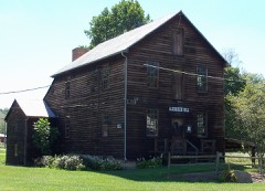
Petersburg Mill6.9 miles1970

Sources for this property

National Archives recordThe nomination case file for reference 95000166 in Record Group 79.
Wikipedia articleCommunity-written account of this property, licensed CC BY-SA.
Carroll CountyAll 11 listed properties in this county.

Provenance

  • Listing record. National Park Service National Register of Historic Places, listed-properties dataset, current to 2026-05-22.
  • Map join. Address geocoded through the United States Census geocoder, then tested against the published boundary of every sheet in the USGS Historical Topographic Map Collection.
  • How this page is made. Listing fields come from federal records; map-sheet coverage is a labelled coordinate-to-boundary calculation, not a source-field claim.
  • Wildfire. Short, Karen C. 2022. Spatial wildfire occurrence data for the United States, 1992-2020 [FPA_FOD_20221014]. 6th Edition. Fort Collins, CO: Forest Service Research Data Archive. https://doi.org/10.2737/RDS-2013-0009.6 Collected with United States Government funding and usable without additional permissions or fees.
  • Specimens. Global Biodiversity Information Facility (GBIF), https://www.gbif.org/. Only records licensed CC0 or CC BY are used. Records licensed CC BY-NC are excluded because this site carries advertising. Images are checked individually and any whose licence is non-commercial, no-derivatives or unreadable is refused.
  • Storms. NOAA National Centers for Environmental Information, Storm Events Database https://www.ncei.noaa.gov/stormevents/ A work of the United States government, no copyright under 17 U.S.C. 105. Narratives are quoted verbatim from the National Weather Service report and are not edited or summarised.