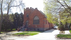
Block
From the record
43 National Register listings published here.
Sources: the National Register database, National Park Service
27 topographic sheets cover 14 settlements here, and 43 properties are on the National Register of Historic Places.
43 National Register listings published here.
Sources: the National Register database, National Park Service
Every property in this county listed on the National Register of Historic Places, with the year it was listed and the federal nomination document.
Every wildfire the federal occurrence database records inside this county: 169 of them, burning about 3,243 acres. 5 started naturally and 5 were recorded as arson. Each settlement page carries the fires within five miles of it.
| Reported cause | Fires |
|---|---|
| Missing data/not specified/undetermined | 69 |
| Debris and open burning | 46 |
| Equipment and vehicle use | 21 |
| Misuse of fire by a minor | 6 |
| Arson/incendiarism | 5 |
| Natural | 5 |
| Fireworks | 4 |
| Smoking | 4 |
| Other causes | 3 |
| Recreation and ceremony | 3 |
| Railroad operations and maintenance | 2 |
| Power generation/transmission/distribution | 1 |
The five largest, by the area the report gives. One of them was set deliberately.
| Date | Cause | Size | Reported by | Name on the report |
|---|---|---|---|---|
| 16 April 2007 | Missing data/not specified/undetermined | 468 acres | South Dakota Wildland Fire Suppression | not named |
| 9 April 2007 | Arson/incendiarism | 400 acres | South Dakota Wildland Fire Suppression | not named |
| 20 March 2015 | Missing data/not specified/undetermined | 400 acres | South Dakota Wildland Fire Suppression | BRANDRIET |
| 9 April 2007 | Debris and open burning | 300 acres | South Dakota Wildland Fire Suppression | not named |
| 23 October 1999 | Debris and open burning | 220 acres | South Shore Volunteer Fire Department | FRANSEN |
| 17 November 2011 | Missing data/not specified/undetermined | 150 acres | South Dakota Wildland Fire Suppression | MCGILLGAN SLOUGH |
| 29 June 2002 | Fireworks | 90 acres | Watertown Volunteer Fire Department | GAME,FISH AND PARKS |
| 14 May 2008 | Debris and open burning | 82 acres | South Dakota Wildland Fire Suppression | not named |
Every settlement page carries the fires within five miles of it - see the settlement index below.
The NOAA Storm Events Database holds 523 reports for this county, causing no deaths, 6 injuries and about $9,246,730 in recorded property damage. Each settlement page carries the reports that name it.
| Kind of event | Reports |
|---|---|
| Hail | 224 |
| Thunderstorm Wind | 170 |
| Flood | 71 |
| Tornado | 34 |
| Flash Flood | 12 |
| Funnel Cloud | 9 |
| Lightning | 3 |
The most serious of them, by death, then injury, then recorded damage. The accounts are quoted exactly as the forecast office filed them.
| When | Event | Place named | Harm | What the report says |
|---|---|---|---|---|
| July 1951 | Tornado (F2) | not stated | 4 hurt | no account filed |
| July 1973 | Tornado (F0) | not stated | 1 hurt, $25,000 | no account filed |
| June 1969 | Tornado (F1) | not stated | 1 hurt, $25,000 | no account filed |
| May 1984 | Tornado (F3) | not stated | $2,500,000 | no account filed |
| July 1983 | Tornado (F3) | not stated | $2,500,000 | no account filed |
| June 1979 | Tornado (F2) | not stated | $2,500,000 | no account filed |
| June 2013 | Thunderstorm Wind | (Aty)Watertown Arpt | $574,000 | Eighty mph winds caused extensive damage to trees along with many structures in and around Watertown. Many trees were downed. |
| April 2019 | Flood | Wallace | $471,700 | no account filed |
| August 1962 | Tornado (F2) | not stated | $250,000 | no account filed |
| April 2023 | Flood | Wallace | $150,000 | no account filed |
| May 2025 | Lightning | Watertown | $100,000 | no account filed |
| May 1996 | Thunderstorm Wind | Watertown | $50,000 | no account filed |
| October 1997 | Thunderstorm Wind | Rauville | $25,000 | A 32 by 120 foot shelter was destroyed. |
| March 2009 | Flash Flood | Foley | $25,000 | no account filed |
| May 1965 | Tornado (F1) | not stated | $25,000 | no account filed |
| September 1995 | Thunderstorm Wind | Watertown | $10,000 | Thunderstorm winds blew down an office trailer at a cement plant. |
| July 1995 | Thunderstorm Wind | Watertown | $6,000 | Apparent microburst with Winds of unknown speed caused broken windows and damage to vehicles from blowing gravel, sand and lumber. The wind was confined to the parking area and facilities of a casino. |
| July 1995 | Thunderstorm Wind | Watertown | $5,000 | Thunderstorm winds caused tree damage. |
| July 1994 | Thunderstorm Wind | Watertown | $5,000 | Thunderstorm Winds blew down several trees. |
| May 1957 | Tornado (F1) | not stated | $30 | no account filed |
| February 2025 | Tornado (EFU) | Appleby | - | A weak thunderstorm generated a brief tornado in an open field. A storm chaser photographed the event. No damage was observed by this tornado, but it was the first February tornado to be documented in South Dakota history. |
| July 2025 | Hail | (Aty)Watertown Arpt | - | Baseball-sized hail was reported near Lake Kampeska. Numerous additional reports of golf-ball sized hail were received from in and around Watertown. |
| July 2025 | Thunderstorm Wind | (Aty)Watertown Arpt | - | The Watertown Automated Surface Observing System recorded a peak wind gust of 71 mph. |
| July 2025 | Flash Flood | Watertown | - | A trained spotter reported street flooding halfway up car tires on roadways in Watertown from brief but intense rainfall. The COOP observer in Watertown recorded 1.22 inches of rainfall in 1 hour. |
| July 2025 | Tornado (EF2) | Henry | - | A tornado tracked for nearly four miles over approximately 21 minutes, leaving a path of significant damage. The event began around 5:55 PM CDT when the tornado touched down in an open field between 168th and 169th Streets, just to the west of 442nd Avenue. The tornado initially tracked to the east, and by about 6:02 PM, it crossed 442nd Avenue. The tornado then turned and started tracking south. The core of the tornado passed about 150 yards to the west of a farmstead, but at approximately 6:03 PM, the tornado was close enough to the farm to start causing significant damage. In fact, video evidence shows debris being lofted into the air before the tornado made its closest approach. The main residence was completely destroyed. An attached garage was dislodged and swept clean from its cement foundation; however, a vehicle in the driveway did not move. The remainder of the house lost its entire roof and many exterior walls, though many interior walls remained standing. One outbuilding was completely destroyed, and many others sustained significant damage. Along the southern edge of the property, a line of nine grain bins was completely swept away. The residents were not home at the time of the tornado, but a beloved horse was killed. At 6:06 PM, the tornado crossed 169th Street and continued south through cropland. Aerial photos revealed that between 169th and 170th Streets, the tornado ripped through several rows of erosion shelterbelt trees. Trees in the path were void of branches, snapped at their bases, and in some spots, reduced to nothing more than stubs. Continuing south, the tornado crossed 170th Street around 6:11 PM and continued across a lake and more cropland, eventually crossing 171st Street. By approximately 6:16 PM, the tornado weakened and dissipated just north of 172nd Street, bringing its 21-minute duration to an end. The tornado was rated an EF2 with peak winds estimated at 135 mph. |
| July 2025 | Flood | Rauville | - | Due to heavy rainfall from persistent thunderstorms, the South Branch Tributary of Mud Creek near Rauville went into flood and crested at 5.13 feet, 1.13 feet above flood stage. This was the 5th highest crest on record for this location. The COOP observer in Rauville measured 3.68 inches of rain. |
| July 2025 | Flood | Rauville | - | Mud Creek near Rauville would briefly flood on the morning of July 28th, cresting at 9.15 or 0.15 inches above flood stage, before quickly dropping below flood stage. |
| July 2025 | Flood | Rauville | - | Willow Creek near Watertown would go into flood due to heavy rain from persistent thunderstorms. The creek would crest July 28th during the mid-morning hours, dropping below flood during the afternoon of the same day. A crest of 10.64 feet was observed, 0.64 feet above flood stage. |
| July 2025 | Thunderstorm Wind | Henry | - | A vehicle was blown off road along the highway north of Henry by an estimated 60 mph wind gust. |
| July 2025 | Flood | Rauville | - | Following 1.22 inches of rainfall measured by the COOP observer in Watertown, the South Branch Tributary of Mud Creek near Rauville rose above flood stage. The river crested at 4.55 feet before falling back below flood stage during the evening of July 24th. |
| August 2025 | Flood | Rauville | - | The Big Sioux River at Watertown Sioux Conifer Road gauge briefly hit flood stage for a few hours on the morning of August 23rd. |
| August 2025 | Flood | Appleby | - | The Big Sioux River below Watertown river gauge would exceed flood stage starting in the morning of August 22nd, peaking at 11.68 or 0.68 feet above flood stage. The river crested in the evening and was back below flood stage by the late morning of August 23rd. |
| August 2025 | Flood | (Aty)Watertown Arpt | - | The Big Sioux River at Watertown Broadway Avenue stream gauge would report flooding during the late morning of August 22nd, peaking on the evening of the 22nd at 10.90 or 0.90 feet above flood stage. The river would remain in flood at this section through the early morning of August 24th. |
| August 2025 | Thunderstorm Wind | (Aty)Watertown Arpt | - | Images posted to social media of multiple uprooted trees near Lake Kampeska, including one that landed on a garage. A nearby weather station recorded a 99 mph wind gust. |
| August 2025 | Thunderstorm Wind | (Aty)Watertown Arpt | - | A peak wind gust of 99 mph was recorded by a personal a weather station at Sandy Shore State Park. |
| August 2025 | Thunderstorm Wind | (Aty)Watertown Arpt | - | The Watertown Regional Airport Automated Surface Observing System (ASOS) recorded a peak gust of 68 mph. |
| August 2025 | Thunderstorm Wind | (Aty)Watertown Arpt | - | The Codington County Emergency Manager called in to report at least 40 large pines had been uprooted or knocked over along the south side of Lake Kampeska. One of these trees fell on a substation and power was knocked out to portions of Watertown for a few hours. |
| August 2025 | Flash Flood | South Shore | - | The Codington County Emergency manager reports water has filled the ditches and is up to the bottoms of several bridges on the main highways with water over some secondary roads northeast of Watertown. Photos were also submitted via Facebook of flooded residences in northeast Watertown. |
| August 2025 | Thunderstorm Wind | Foley | - | A trained spotter reported that hay bales had been rolled over 100 ft across a field with thunderstorm winds. The nearby ASOS at Watertown Regional Airport recorded a peak wind gust of 68 mph. |
| August 2025 | Thunderstorm Wind | Foley | - | A trained spotter reported numerous tree branches up to 6 inches in diameter had come down. Some had blown nearly 100 feet across into a field. |
| August 2025 | Thunderstorm Wind | Waverly | - | The Codington County Emergency Manager reported multiple trees had been snapped due to strong thunderstorm winds. An empty grain bin had also been blown open at this location. |
| August 2025 | Flood | Rauville | - | The South Branch Tributary of Mud Creek near Rauville went into flood during the morning hours of August 6th. A peak crest of 4.91 feet was recorded at 1045 am CST on August 6th, with the creek falling below flood stage on the afternoon of August 7th. |
| August 2025 | Thunderstorm Wind | (Aty)Watertown Arpt | - | Numerous trees down in and around the city of Watertown. The ASOS at Watertown Regional Airport recorded a peak wind gust of 71 mph. |
| August 2025 | Flood | Rauville | - | Willow Creek near Watertown would go into flood on the morning of August 6th, cresting at 10.88 feet, or 0.88 above flood stage by the afternoon, and drop below flood stage by that evening. |
| August 2025 | Flood | Rauville | - | Mud Creek at Rauville would go into flood during the early morning hours of August 6th, cresting in the late morning 1.34 feet above flood stage, before dropping below flood on August 7th in the afternoon. |
| August 2025 | Flood | Florence | - | The Big Sioux River near Watertown would go into flood around mid-day on August 6th, reaching 10.65 feet, or 0.65 feet above flood stage on the evening of the 6th. This portion of the river would remain in flood through the morning of the 7th. Flooding would mainly impact agricultural lands. |
| August 2025 | Flood | Rauville | - | The portion of the Big Sioux River at Watertown Sioux Conifer Road went into flood at 845 am CST August 7th, cresting at 9.15 feet, or 0.15 feet above flood stage. The river fell below flood at 9 pm CST August 7th with the flooding primarily limited to low spots. |
| August 2025 | Flash Flood | Appleby | - | Heavy rainfall on saturated soils resulted in flooding in and around Watertown, with street flooding reported across the city. Northeast of Watertown, a vehicle left the Interstate after encountering some 10 inches of water on the roadway that flooded both lanes near mile marker 182. When emergency crews arrived, the car was barely visible, with only the rear bumper above water. The occupant of the car swam to safety, was checked out on the scene by paramedics, but did not require any further medical attention.|Due to flooding, Interstate 29 was shut down between Exit 181 and Exit 185. |
| August 2025 | Flood | Rauville | - | The South Branch Tributary Mud Creek near Rauville went into flood during the early morning hours of August 22nd, cresting at 4.91 feet, 0.91 feet above flood stage around mid-day. The creek would remain in flood through the early afternoon of August 23rd. |
| August 2025 | Flood | Rauville | - | Willow Creek near Watertown went into flood on the evening of August 21st, topping out at 12.86 feet, or 2.86 feet above flood stage during the early morning hours of August 22nd before slowly falling, dropping below flood stage at 1230 AM August 23rd. |
| September 2025 | Funnel Cloud | Waverly | - | A trained spotter submitted a photo of a funnel cloud near Waverly. |
| July 2024 | Flood | (Aty)Watertown Arpt | - | Campers reported flooding in portions of the Stokes-Thomas Lake City Park campground. Photos submitted included deep standing water with partially inundated campers and tents. |
| July 2024 | Flood | Rauville | - | The South Branch Tributary Mud Creek near Rauville rose above flood stage during the early morning hours of July 5th, peaking at 4.64 feet at 1015am CST, which is 0.64 feet above flood stage, before falling back below flood stage on July 6th at 345am CST. |
| July 2024 | Thunderstorm Wind | Rauville | - | A trained spotter indicated wind gusts from storms had reached 60 mph. |
| July 2024 | Flood | Rauville | - | Mud Creek near Rauville rose above flood stage on July 5th at 1145am CST, cresting at 9.30 feet, or 0.3 feet above flood stage on July 5th at 5pm, before slowly falling below flood stage on July 6th at 330am CST. |
| June 2024 | Hail | (Aty)Watertown Arpt | - | A member of the public submitted storm damage photos from estimated golfball size hail, including several windows that were shattered. |
| June 2024 | Flood | Watertown | - | A vehicle was reported stalled in flood waters in the northwest portion of the city of Watertown. |
| August 2024 | Hail | Florence | - | A trained spotter reported a 3/4 mile swath of crop damage from estimated quarter to golfball sized hail. |
| April 2023 | Flood | Watertown | - | Pelican Lake levels to rose above flood stage on April 15th. The lake peaked at a level of 1713.6 on the afternoon of April 20th. |
| April 2023 | Flood | Rauville | - | The Big Sioux river gauge in Watertown at Sioux Conifer Road peaked on the afternoon of April 12th at 10.9 which is moderate flood stage. This only affected pasture land in the area. |
The Survey's mineral resources record lists 39 workings inside this county. 6 still produce and 33 are closed or unrecorded. Each settlement page carries the workings within five miles of it.
| Commodity | Workings |
|---|---|
| Sand and Gravel, Construction | 39 |
The least common of them first, because a county's hundredth gravel pit says nothing its first ten did not.
| Where | Site | Commodity | Status | Recorded |
|---|---|---|---|---|
| Cline Pit | Sand and Gravel, Construction | Producer | ||
| Gravel Pit | Sand and Gravel, Construction | Past Producer | ||
| Gravel Pit | Sand and Gravel, Construction | Past Producer | ||
| Gravel Pit | Sand and Gravel, Construction | Past Producer | ||
| Gravel Pit | Sand and Gravel, Construction | Past Producer | ||
| Gravel Pit | Sand and Gravel, Construction | Past Producer | ||
| Gravel Pit | Sand and Gravel, Construction | Past Producer | ||
| Gravel Pit | Sand and Gravel, Construction | Past Producer | ||
| Gravel Pit | Sand and Gravel, Construction | Past Producer | ||
| Gravel Pit | Sand and Gravel, Construction | Past Producer | ||
| Gravel Pit | Sand and Gravel, Construction | Past Producer | ||
| Gravel Pit | Sand and Gravel, Construction | Past Producer | ||
| Gravel Pit | Sand and Gravel, Construction | Past Producer | ||
| Gravel Pit | Sand and Gravel, Construction | Past Producer | ||
| Gravel Pit | Sand and Gravel, Construction | Past Producer | ||
| Gravel Pit | Sand and Gravel, Construction | Past Producer | ||
| Gravel Pit | Sand and Gravel, Construction | Past Producer | ||
| Gravel Pit | Sand and Gravel, Construction | Past Producer | ||
| Gravel Pit | Sand and Gravel, Construction | Past Producer | ||
| Gravel Pit | Sand and Gravel, Construction | Past Producer | ||
| Gravel Pit | Sand and Gravel, Construction | Past Producer | ||
| Gravel Pit | Sand and Gravel, Construction | Past Producer | ||
| Gravel Pit | Sand and Gravel, Construction | Past Producer | ||
| Gravel Pit | Sand and Gravel, Construction | Past Producer | ||
| Gravel Pit | Sand and Gravel, Construction | Past Producer | ||
| Gravel Pit | Sand and Gravel, Construction | Past Producer | ||
| Gravel Pit | Sand and Gravel, Construction | Past Producer | ||
| Gravel Pit | Sand and Gravel, Construction | Past Producer | ||
| Gravel Pit | Sand and Gravel, Construction | Past Producer | ||
| Gravel Pit | Sand and Gravel, Construction | Past Producer | ||
| Gravel Pit | Sand and Gravel, Construction | Past Producer | ||
| Gravel Pit | Sand and Gravel, Construction | Past Producer | ||
| Gravel Pit | Sand and Gravel, Construction | Past Producer | ||
| Junger Pit | Sand and Gravel, Construction | Past Producer | ||
| Little Pit | Sand and Gravel, Construction | Producer | ||
| Mc Laughlin Pit & Mill | Sand and Gravel, Construction | Producer | ||
| Mcbride Pit | Sand and Gravel, Construction | Producer | ||
| Rauville | Sand and Gravel, Construction | Producer | ||
| Withrow Sand & Gravel Pit | Sand and Gravel, Construction | Producer |
Named settlements recorded in the Geographic Names Information System, each with the topographic sheets covering it. Villages, hamlets and abandoned places alike. Each is shown with the nearest named watercourse or landform and the survey quadrangle it falls on.
Lake township · 57201 · On Mud Creek · Watertown West quadrangle
8 sheets, 1953 to 1985