 Block
From the record
16 National Register listings published here.
Sources: the National Register database, National Park Service
26 topographic sheets cover 19 settlements here, and 16 properties are on the National Register of Historic Places.
16 National Register listings published here.
Sources: the National Register database, National Park Service
Every property in this county listed on the National Register of Historic Places, with the year it was listed and the federal nomination document.
| Photograph | Property | Type | Listed | Reference |
|---|---|---|---|---|
 | Chapel Emmanuel Railroad Car | structure | 1976 | 76001740 |
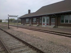 | Chicago, Milwaukee, St. Paul, and Pacific Railroad Depot | building | 1989 | 89001719 |
| Matthew W. Daly House | building | 1988 | 88000571 | |
 | J. Whitney Goff Round Barn | building | 2004 | 04000469 |
| Abraham Hegdahl Farm | district | 2004 | 03001526 | |
| Herschell-Spillman Steam Riding Gallery | structure | 2016 | 16000825 | |
| Lake Badus Rural Agricultural Historic District | district | 2003 | 02001428 | |
 | Lake County Courthouse | building | 1993 | 92001861 |
| Lake Madison Lutheran Church | building | 2000 | 00001220 | |
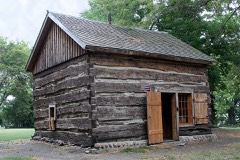 | Herman Luce Cabin | building | 1978 | 78002561 |
| William A. Mackay House | building | 1976 | 76001741 | |
| Madison Historic District | district | 1976 | 76001742 | |
| Madison Masonic Temple | building | 1990 | 89002335 | |
| St. Ann's Catholic Church of Badus | building | 1979 | 79002403 | |
| St. Williams Catholic Church | building | 1999 | 99000203 | |
| Washington School | building | 2010 | 10000411 |
Every wildfire the federal occurrence database records inside this county: 38 of them, burning about 487 acres. 1 started naturally and 5 were recorded as arson. Each settlement page carries the fires within five miles of it.
| Reported cause | Fires |
|---|---|
| Debris and open burning | 16 |
| Missing data/not specified/undetermined | 9 |
| Arson/incendiarism | 5 |
| Equipment and vehicle use | 4 |
| Fireworks | 1 |
| Recreation and ceremony | 1 |
| Smoking | 1 |
| Natural | 1 |
The five largest, by the area the report gives. None of them was recorded as arson.
| Date | Cause | Size | Reported by | Name on the report |
|---|---|---|---|---|
| 1 April 2017 | Missing data/not specified/undetermined | 109 acres | South Dakota Wildland Fire Suppression | HODNE |
| 8 January 2008 | Debris and open burning | 90 acres | South Dakota Wildland Fire Suppression | not named |
| 8 May 2009 | Debris and open burning | 42 acres | South Dakota Wildland Fire Suppression | not named |
| 4 February 2005 | Debris and open burning | 40 acres | South Dakota Wildland Fire Suppression | not named |
| 25 October 2005 | Equipment and vehicle use | 30 acres | South Dakota Wildland Fire Suppression | not named |
| 10 October 1999 | Equipment and vehicle use | 20 acres | Wentworth Volunteer Fire Department | WOLDT |
| 4 October 2008 | Missing data/not specified/undetermined | 20 acres | South Dakota Wildland Fire Suppression | not named |
| 19 October 2000 | Equipment and vehicle use | 20 acres | Madison Wetland Management District | VANHOVE |
Every settlement page carries the fires within five miles of it - see the settlement index below.
The NOAA Storm Events Database holds 334 reports for this county, causing 1 death, no injuries and about $10,152,230 in recorded property damage. Each settlement page carries the reports that name it.
| Kind of event | Reports |
|---|---|
| Hail | 150 |
| Thunderstorm Wind | 130 |
| Tornado | 24 |
| Flash Flood | 12 |
| Flood | 12 |
| Lightning | 3 |
| Funnel Cloud | 3 |
The most serious of them, by death, then injury, then recorded damage. The accounts are quoted exactly as the forecast office filed them.
| When | Event | Place named | Harm | What the report says |
|---|---|---|---|---|
| May 2012 | Flash Flood | Orland | 1 killed, $2,000,000 | Heavy rainfall of up to 6 inches caused flash flooding of numerous roads, parks, fields, other low areas, and buildings including homes. At least 90 homes were heavily damaged in Madison by the flooding, including at least two with basement walls washed out. A basement wall of a dentists business was also washed out and the basement flooded with 9 feet of water. Numerous personal possessions in flooded homes and businesses were destroyed. The flash flooding included Memorial Creek, and there was a fatality when an out of state visitor drowned when attempting to cross the flooded creek. While this fatality and most of the damage was in Madison, many rural roads and fields were flooded in the area, and east to near the town of Wentworth. |
| August 1992 | Tornado (F2) | not stated | $2,500,000 | no account filed |
| September 2019 | Flood | Orland | $1,420,000 | Heavy rain from September 10-12 (as much as 8.81 inches 2 miles north of Chester, 7.36 inches 4 miles west northwest of Rutland, and 7.01 inches 2 miles south of Winfred) led to widespread areal flooding. Flooding was most significant around Madison, where ponding waters led to the evacuation of 30 people by boat and payloader. As many as 200 residences were inundated by water in Madison. Highway 34 was closed both east and west of Madison, Highway 19 was closed south of Madison, and travel was not advised across most of the county with water over most township and county roads. Lake Herman State Park was closed due to high water and remained so for most of the month. No wake zones were established on Lake Madison, Lake Herman, and Brant Lake. Other flooding resulted in the loss of crops and damage to public infrastructure including numerous county and township roads, culverts, and some bridges. Property damage costs are rough estimates. Crop loss estimates provided by the United States Department of Agriculture. |
| June 2024 | Flood | Orland | $750,000 | Rainfall amounts across Lake County from June 20-22 ranged from 3 to 9 inches. Overland flooding ensued with the majority of road damage to areas south of South Dakota Highway 34 and west of South Dakota Highway 19. County wide, nine homes reported minor to major flood damage with the majority of the impacts being water or sewer backup into basements. Preliminary damage assessments estimate loss to public infrastructure across the county to be in excess of 750 thousand dollars. |
| July 2000 | Hail | Countywide | $500,000 | Large hail severely damaged buildings mobile homes, vehicles, and crops. Walls and vehicles were dented, paint was stripped, many windows were broken, holes were punched in roofs, and trees were severely damaged. There was also widespread damage to crops, especially corn crops which had previously been in excellent condition. Damage was especially notable in the Nunda, Madison, Lake Madison, Wentworth, and Chester areas. |
| July 2000 | Thunderstorm Wind | Countywide | $500,000 | Thunderstorm winds caused widespread tree damage, damaged 90 to 95 trailers along the shore of Lake Madison, damaged more trailers near Wentworth, and damaged farm buildings. |
| October 1996 | Thunderstorm Wind | Madison | $400,000 | no account filed |
| March 2019 | Flood | Orland | $310,000 | Water was flowing across SD Highway 34/U.S. 81 west of 447th Avenue, just west of Junius. Other flooding resulted in damage to public infrastructure including county and township roads and culverts. |
| June 1970 | Tornado (F3) | not stated | $250,000 | no account filed |
| September 2010 | Flash Flood | Orland | $200,000 | Heavy rainfall of several inches caused widespread flash flooding of streets, fields, parks, basements, and other low areas in Madison, with flooding of roads and fields also reported outside of the town. Park Creek, which runs through Madison, was affected and contributed to the flooding, and the rock walls of the creek bed in town were damaged. Some of the flooded roads were also damaged. |
| July 2004 | Thunderstorm Wind | Madison | $200,000 | Thunderstorm winds damaged businesses and blew down road signs, as well as power poles and lines. Numerous trees were damaged and uprooted. Most of the damage was localized over a few blocks. |
| June 1998 | Thunderstorm Wind | Madison | $200,000 | no account filed |
| July 2011 | Thunderstorm Wind | Wentworth | $150,000 | Thunderstorm winds caused widespread tree damage, including several trees uprooted or flattened, and others snapped a few feet above the ground. The winds also destroyed a 60 foot by 90 foot shed. Several homes and vehicles were damaged, including a car crushed by a tree and a garage heavily damaged by a falling tree. The winds caused damage to power lines and poles, both directly and from wind blown debris, with a resulting power outage in most of Wentworth. |
| September 2019 | Flash Flood | Madison | $100,000 | State Highway 34 was under a foot or two of flowing water both west and east of Madison. Several homes were evacuated due to flooding. |
| April 2011 | Flood | Ramona | $100,000 | Flooding of lakes and lowlands, including Lake Madison and farmland, continued in the county through April. While flooding of small streams abated, lake and lowland flooding continued with very slow improvement. Many roads remained flooded, with additional damage. High water and groundwater levels resulting from record precipitation in the previous year was the main reason that the flooding either grew worse or improved so slowly. |
| June 2014 | Flood | Ramona | $50,000 | Persistent moderate to heavy rain caused flooding of fields and other lowlands, including several roads, homes, and businesses. This flooding lasted for almost two days, and was aggravated locally by additional storms during that time. Some roads were damaged or washed out. |
| April 2002 | Hail | Chester | $50,000 | Large hail damaged vehicles, roofs, and trees. |
| July 2000 | Tornado (F2) | Madison | $50,000 | A tornado destroyed storage sheds, lighting, fencing, and caused other damage at Lake County Speedway. The tornado also damaged crops over a small area. |
| June 1994 | Thunderstorm Wind | Lake Madison | $50,000 | A large tree was blown over and demolished half of a mobile home. |
| September 2019 | Flood | Nunda | $25,000 | Significant ponding of water occurred over much of the area around Madison and Chester. Street flooding occured throughout much of Madison. Property damage costs are rough estimates. |
| September 2019 | Flash Flood | Madison | $25,000 | Water was flowing at several inches to a foot across numerous roads in Madison. |
| June 1992 | Tornado (F1) | not stated | $25,000 | no account filed |
| August 1982 | Tornado (F1) | not stated | $25,000 | no account filed |
| June 1970 | Tornado (F1) | not stated | $25,000 | no account filed |
| September 2019 | Flash Flood | Madison | $20,000 | Heavy rainfall produced flash flooding of Silver Creek on the southeast side of Madison. | Two to three feet of water made roads impassable. |
| June 2003 | Thunderstorm Wind | Chester | $20,000 | Thunderstorm winds tore the roof off a hog confinement building and blew over a semi truck. |
| June 2001 | Thunderstorm Wind | Ramona | $20,000 | Thunderstorm winds caused damage to trees and a house. Eight to twelve inch diameter tree limbs were broken off. |
| June 2001 | Thunderstorm Wind | Madison | $20,000 | Thunderstorm winds uprooted a large tree, which fell on the roof of a garage and crashed into a window of the attached home. |
| October 1997 | Thunderstorm Wind | Madison | $20,000 | no account filed |
| August 1996 | Thunderstorm Wind | Madison | $20,000 | no account filed |
| July 2015 | Thunderstorm Wind | Madison | $15,000 | Thunderstorm winds blew over an empty semi trailer, and blew a manufactured home off another trailer. The winds also caused tree damage, including several large trees blown down. |
| July 2019 | Thunderstorm Wind | Smiths Park | $10,000 | Four boats were lifted off their racks along the south shore of Lake Madison. |
| May 2012 | Thunderstorm Wind | Madison | $10,000 | Thunderstorm winds blew down trees and power lines. |
| June 2010 | Thunderstorm Wind | Madison Muni Arpt | $10,000 | Thunderstorm winds blew shingles off roofs, and moved docks on Lake Madison. |
| July 2000 | Hail | Chester | $10,000 | Large hail caused damage to vehicles and crops, but the amount of crop damage was not known. |
| July 2000 | Thunderstorm Wind | Wentworth | $10,000 | Thunderstorm winds caused tree damage, including numerous branches down. |
| June 1995 | Thunderstorm Wind | not stated | $10,000 | Thunderstorm winds from two storms blew down many tree branches and limbs. Lightning and some of the broken limbs caused power outages. |
| September 2019 | Flood | Chester | $5,000 | After excessive two-day rainfall during September 10-12 (record 2-day 8.52 inches 2 miles north of Chester), Skunk Creek near Chester (gage site SCCS2) reached the second highest stage on record of 0.33 feet above flood stage on September 12. Significant amounts of agricultural land were inundated. |
| May 2012 | Thunderstorm Wind | Madison | $5,000 | Thunderstorm winds blew a steel pole shed building across a road. The winds also caused tree damage. The winds were accompanied by heavy rain. |
| May 2011 | Thunderstorm Wind | Madison | $5,000 | Thunderstorm winds blew down trees and power lines, causing a power outage. At least one house in Madison suffered minor damage from tree debris. |
| June 2008 | Thunderstorm Wind | Madison | $5,000 | Thunderstorm winds destroyed a small ticket booth at Prairie Village on the west side of Madison. The winds also damaged an entrance sign near the ticket booth. |
| July 1997 | Thunderstorm Wind | Nunda | $5,000 | Thunderstorm winds caused tree damage. |
| June 1999 | Thunderstorm Wind | Madison | $5,000 | no account filed |
| July 1998 | Thunderstorm Wind | Winfred | $5,000 | no account filed |
| October 1997 | Thunderstorm Wind | Chester | $5,000 | no account filed |
| October 1994 | Thunderstorm Wind | Madison SD | $3,000 | Thunderstorm winds destroyed a 50 x 100 foot machine shed. |
| May 1980 | Tornado (F1) | not stated | $2,500 | no account filed |
| June 1956 | Tornado (F2) | not stated | $2,500 | no account filed |
| June 1999 | Thunderstorm Wind | Madison | $2,000 | Thunderstorm winds loosened a tin roof at a seed company and caused tree damage. |
| May 2000 | Lightning | Madison | $1,000 | Lightning struck a power pole and damaged a transformer. |
| May 1996 | Lightning | Chester | $1,000 | no account filed |
| June 2005 | Lightning | Madison | $200 | Lightning struck a large tree in a front yard, stripping the bark off the tree. The tree had to be removed. |
| June 1957 | Tornado (F2) | not stated | $30 | no account filed |
| July 2025 | Thunderstorm Wind | Smiths Park | - | Thunderstorm wind gusts were measured by a personal weather station. |
| April 2024 | Hail | Ramona | - | Hail was mostly pea to dime sized, but several were as large as a quarter. |
| July 2024 | Thunderstorm Wind | Madison | - | Tree limbs up to 3 inches in diameter were taken down by thunderstorm wind gusts. |
| June 2024 | Flash Flood | Orland | - | After 2 to 3 inches of rainfall in the hour leading up to the time, water flowed over the road at the intersection of 447th Avenue and 241st Street. For a more comprehensive description of flood damage, please see other entries for areal and river flooding for Lake County. |
| June 2024 | Thunderstorm Wind | Orland | - | Thunderstorm wind gusts just ahead of the storm knocked numerous branches down across the yard. Crop damage is an estimate from insured losses. Information provided by the United States Department of Agriculture. |
| May 2022 | Hail | Junius | - | Crop damage is an estimate from insured losses. Information provided by the United States Department of Agriculture. |
| May 2022 | Thunderstorm Wind | Nunda | - | Five large trees were knocked down and a roof blown off of a barn. Crop damage is an estimate from insured losses. Information provided by the United States Department of Agriculture. |
The Survey's mineral resources record lists 8 workings inside this county. 3 still produce and 5 are closed or unrecorded. Each settlement page carries the workings within five miles of it.
| Commodity | Workings |
|---|---|
| Sand and Gravel, Construction | 8 |
The least common of them first, because a county's hundredth gravel pit says nothing its first ten did not.
| Where | Site | Commodity | Status | Recorded |
|---|---|---|---|---|
| Gravel Pit | Sand and Gravel, Construction | Past Producer | ||
| Gravel Pit | Sand and Gravel, Construction | Past Producer | ||
| Gravel Pit | Sand and Gravel, Construction | Past Producer | ||
| Gravel Pit | Sand and Gravel, Construction | Past Producer | ||
| Gravel Pit | Sand and Gravel, Construction | Past Producer | ||
| Hilde Pipe & Gravel, Inc | Sand and Gravel, Construction | Producer | ||
| Lake County Sand & Gravel Pit | Sand and Gravel, Construction | Producer | ||
| Matson Sand & Gravel Pit | Sand and Gravel, Construction | Producer |
Named settlements recorded in the Geographic Names Information System, each with the topographic sheets covering it. Villages, hamlets and abandoned places alike. Each is shown with the nearest named watercourse or landform and the survey quadrangle it falls on.
Lake View township · 57042 · On Park Creek · Lake Madison quadrangle
6 sheets, 1955 to 1985
Orland township · 57042 · Lake Herman quadrangle
6 sheets, 1955 to 1985
No longer a settlement
Summit township · 57050 · Sinai quadrangle
9 sheets, 1953 to 1985
No longer a settlement
Franklin township · 57042 · Buffalo Trading Post quadrangle
6 sheets, 1955 to 1985
Chester township · 57075 · On Franklin Creek · Wentworth quadrangle
7 sheets, 1955 to 1985
The vanished settlements of Lake County: the places named above that are no longer on the map.