 Block
From the record
One of 15 National Register listings published here for Charles Mix County · listed in 2007 · category: Building · built in 1919.
Sources: the case file at the National Archives · the National Register database, National Park Service
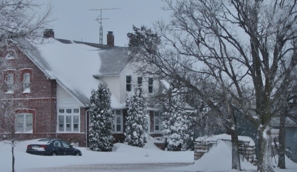
Built in 1919. Listed on the National Register of Historic Places in 2007.
One of 15 National Register listings published here for Charles Mix County · listed in 2007 · category: Building · built in 1919.
Sources: the case file at the National Archives · the National Register database, National Park Service
Regional context, not property-specific evidence. The federal wildfire occurrence database lists 48 fires within 5 miles of Wagner House between 2002 and 2020, burning about 707 acres in total. 1 started naturally. 1 was recorded as arson. Distance is straight-line from the map coordinates, so a fire counted here may appear on a neighbouring settlement's page as well.
| Reported cause | Fires |
|---|---|
| Missing data/not specified/undetermined | 30 |
| Debris and open burning | 8 |
| Railroad operations and maintenance | 3 |
| Misuse of fire by a minor | 3 |
| Recreation and ceremony | 1 |
| Equipment and vehicle use | 1 |
| Arson/incendiarism | 1 |
| Natural | 1 |
The most recent of them, most recent first, with the day each was reported and the service that recorded it.
| Date | Cause | Size | Reported by | Name on the report |
|---|---|---|---|---|
| 9 September 2014 | Missing data/not specified/undetermined | 30 acres | South Dakota Wildland Fire Suppression | HAUCK |
| 6 September 2003 | Misuse of fire by a minor | 40 acres | Yankton Agency | A0803011 |
| 19 September 2015 | Misuse of fire by a minor | under an acre | South Dakota Wildland Fire Suppression | DANTE FOREST |
| 15 September 2011 | Debris and open burning | 1.0 acres | Yankton Agency | 31 COURNOYER |
| 13 September 2005 | Natural | 20 acres | South Dakota Wildland Fire Suppression | not named |
| 9 August 2005 | Missing data/not specified/undetermined | 1.0 acres | South Dakota Wildland Fire Suppression | not named |
| 8 August 2010 | Missing data/not specified/undetermined | 1.0 acres | South Dakota Wildland Fire Suppression | #26 KOUPAL |
| 10 August 2011 | Missing data/not specified/undetermined | under an acre | South Dakota Wildland Fire Suppression | POWERS DENNIS |
Regional context, not property-specific evidence. The federal mineral resources record lists 4 workings within 5 miles of Wagner House: 4 past producers. None of them still produces. What was taken out: Sand and Gravel, Construction. Distance is straight-line from the map coordinates, so a quarry counted here may appear on a neighbouring settlement's page as well.
| Where | Site | Commodity | Status | Recorded |
|---|---|---|---|---|
| Ed Bednar Gravel Pit | Sand and Gravel, Construction | Past Producer | ||
| Moyasis Pit | Sand and Gravel, Construction | Past Producer | ||
| Otto Wormsbecker Gravel Pit | Sand and Gravel, Construction | Past Producer | ||
| Soukup Pit | Sand and Gravel, Construction | Past Producer |
Regional context, not property-specific evidence. The National Weather Service names Wagner, the town this property stands in, in 64 storm reports between 1996 and 2025: 36 hail, 19 thunderstorm wind, 3 tornado, 3 flash flood. No death or injury is recorded in these reports. Each account below is quoted exactly as the forecast office filed it, from the NOAA Storm Events Database, and each date opens the federal record of that event.
| When | Event | Place named | Harm | What the report says |
|---|---|---|---|---|
| August 2000 | Tornado (F1) | Wagner | $100,000 | A tornado damaged three homes, including a roof peeled off, and damaged a corn crop. The amount of crop damage was not known. |
| August 2019 | Flood | Wagner | $25,000 | Heavy early morning rainfall resulted in ponding of 1 to 2 feet of water over parking lots in many areas on the west side of Wagner, including across the road from the fire station. |
| June 2021 | Thunderstorm Wind | Wagner | $15,000 | Numerous power lines were downed by thunderstorm winds in Wagner. Property damage costs are a rough estimate. |
| August 2019 | Flood | Wagner | $10,000 | After waters had receded earlier in the day, a plugged culvert resulted in extensive ponding of water along South Dakota Highway 46/50 on the west side of Wagner. Additional flooding was reported near 5th Street on the south side of Wagner, near the location of the plugged culvert. |
| June 2003 | Hail | Wagner | $10,000 | Large hail cracked windows and damaged siding. |
| July 1999 | Thunderstorm Wind | Wagner | $10,000 | no account filed |
| June 2020 | Hail | Wagner | $5,000 | Cars damaged due to hail up to golf ball size on the west side of Wagner. Property damage costs are rough estimates. |
| August 2019 | Flood | Wagner | $5,000 | Several inches of water was flowing over South Dakota Highway 50. |
| August 2010 | Thunderstorm Wind | Wagner | $5,000 | Thunderstorm winds blew down power poles and lines. |
| August 2010 | Thunderstorm Wind | Wagner | $1,000 | Thunderstorm winds tore 15 feet of soffit from a house. |
| July 2025 | Thunderstorm Wind | Wagner | - | Thunderstorm wind gusts were measured by a personal weather station. |
| July 2025 | Thunderstorm Wind | Wagner | - | Thunderstorm wind gusts were measured by a personal weather station. |
| June 2025 | Thunderstorm Wind | Wagner | - | Winds were measured by a personal weather station. |
| July 2023 | Thunderstorm Wind | Wagner | - | Multiple personal weather system sites around Wagner recorded peak wind gusts between 59 and 62 mph. |
| June 2023 | Hail | Wagner | - | Large hail up to half dollar size was shown in social media picture. |
| June 2022 | Thunderstorm Wind | Wagner | - | A large pine tree was blown down by thunderstorm winds, as well as several large limbs. |
| June 2020 | Hail | Wagner | - | Crop damages are estimates from insured losses. Information provided by the United States Department of Agriculture. |
| August 2018 | Hail | Wagner | - | Report of damage to crops and vehicles on social media. |
| May 2016 | Flash Flood | Wagner | - | Heavy rain from thunderstorms caused flash flooding of Chateau Creek, with cropland, grassland, and a few roads flooded. |
| May 2015 | Tornado (EF0) | Wagner | - | A tornado formed and moved over fields, damaging some trees, before crossing into Douglas County. |
| August 2010 | Thunderstorm Wind | Wagner | - | Thunderstorm winds caused tree damage, including branches blown down. |
| June 2009 | Thunderstorm Wind | Wagner | - | Thunderstorm winds blew down several branches. |
| June 2008 | Flash Flood | Wagner | - | Heavy rain caused flash flooding of numerous roads and fields. At least two creeks overflowed, adding to the flooding. |
| August 2007 | Hail | Wagner | - | Large hail dented cars and cracked windshields. The amount of damage was not known. |
| June 2007 | Thunderstorm Wind | Wagner | - | Thunderstorm winds caused tree and power line damage, with resulting power outages. Up to 8 inch diameter tree limbs were blown down. |
| June 2007 | Thunderstorm Wind | Wagner | - | Thunderstorm winds caused tree damage, including several branches blown down. |
| August 2007 | Hail | Wagner | - | Very large hail broke windows, dented vehicles, and damaged roofs. Crop damage was also reported. The largest stone was verifed at 6 1/8 inches in diamater with a weight of 1.25 pounds. The amount of property and crop damage was not known. |
| July 2005 | Hail | Wagner | - | A prolonged period of small hail, accompanied by strong winds, damaged corn and soybean crops. Some bean fields were destroyed. |
| June 2005 | Flash Flood | Wagner | - | Heavy rain caused flooding of numerous roads and several small streams. State Highway 50 was closed because of flooding between Lake Andes and Ravinia. In Wagner, water up to 3 feet deep flooded roads near a stream. |
| July 2004 | Tornado (F0) | Wagner | - | A tornado moved from northwest to southeast on a ten mile track over open country. The tornado damaged crops, mainly corn, but did not cause any property damage. The tornado was observed to be about a quarter mile wide early in its life, then steadily narrowed before roping out and dissipating. |
| June 2003 | Hail | Wagner | - | Large hail covered the ground to a depth of several inches. Snowplows were needed to clear roads. |
| June 2003 | Hail | Wagner | - | Large hail covered the ground to a depth of several inches. Wind blew the hail into drifts as high as four feet. |
| August 2002 | Thunderstorm Wind | Wagner | - | Thunderstorm winds blew down a fence and caused tree damage. |
| June 2020 | Hail | Wagner | - | no account filed |
| June 2020 | Hail | Wagner | - | no account filed |
| June 2020 | Hail | Wagner | - | no account filed |
| May 2016 | Hail | Wagner | - | no account filed |
| May 2016 | Hail | Wagner | - | no account filed |
| May 2008 | Hail | Wagner | - | no account filed |
| June 2008 | Hail | Wagner | - | no account filed |
| June 2008 | Hail | Wagner | - | no account filed |
| June 2008 | Hail | Wagner | - | no account filed |
| August 2007 | Hail | Wagner | - | no account filed |
| June 2007 | Thunderstorm Wind | Wagner | - | no account filed |
| September 2006 | Hail | Wagner | - | no account filed |
| May 2005 | Hail | Wagner | - | no account filed |
| September 2005 | Hail | Wagner | - | no account filed |
| May 2004 | Hail | Wagner | - | no account filed |
| April 2004 | Hail | Wagner | - | no account filed |
| July 2004 | Hail | Wagner | - | no account filed |
| June 2003 | Thunderstorm Wind | Wagner | - | no account filed |
| July 2002 | Hail | Wagner | - | no account filed |
| August 2002 | Hail | Wagner | - | no account filed |
| July 2002 | Hail | Wagner | - | no account filed |
| July 2002 | Hail | Wagner | - | no account filed |
| August 2001 | Hail | Wagner | - | no account filed |
| July 1998 | Thunderstorm Wind | Wagner | - | no account filed |
| July 1998 | Thunderstorm Wind | Wagner | - | no account filed |
| July 1998 | Hail | Wagner | - | no account filed |
| July 1998 | Hail | Wagner | - | no account filed |
No historic map-sheet match is published for this property yet. That does not mean no map exists. This record needs a coordinate-quality review before it can be joined to a sheet boundary. Browse the county's mapped places while that work is pending.
Other National Register properties close enough to walk or drive between, ordered by distance from this one. Both positions come from the same geocoding pass that matched these properties to their map sheets.
| Photograph | Property | Distance | Listed |
|---|---|---|---|
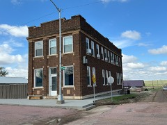 | Security State Bank of Dante | 3.7 miles | 2018 |
| National Archives record | The nomination case file for reference 07001209 in Record Group 79. |
| Charles Mix County | All 15 listed properties in this county. |