 Block
From the record
One of 15 National Register listings published here for Charles Mix County · listed in 2018 · category: Building · built in 1920.
Sources: the National Register database, National Park Service
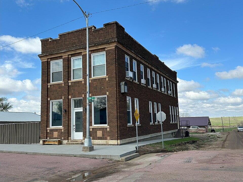
Built in 1920. Listed on the National Register of Historic Places in 2018.
One of 15 National Register listings published here for Charles Mix County · listed in 2018 · category: Building · built in 1920.
Sources: the National Register database, National Park Service
Regional context, not property-specific evidence. The federal wildfire occurrence database lists 45 fires within 5 miles of Security State Bank of Dante between 2002 and 2020, burning about 827 acres in total. None started naturally. None was recorded as arson. Distance is straight-line from the map coordinates, so a fire counted here may appear on a neighbouring settlement's page as well.
| Reported cause | Fires |
|---|---|
| Missing data/not specified/undetermined | 26 |
| Debris and open burning | 8 |
| Railroad operations and maintenance | 4 |
| Equipment and vehicle use | 3 |
| Misuse of fire by a minor | 3 |
| Recreation and ceremony | 1 |
The most recent of them, most recent first, with the day each was reported and the service that recorded it.
| Date | Cause | Size | Reported by | Name on the report |
|---|---|---|---|---|
| 9 September 2014 | Missing data/not specified/undetermined | 30 acres | South Dakota Wildland Fire Suppression | HAUCK |
| 6 September 2003 | Misuse of fire by a minor | 40 acres | Yankton Agency | A0803011 |
| 19 September 2015 | Misuse of fire by a minor | under an acre | South Dakota Wildland Fire Suppression | DANTE FOREST |
| 19 September 2003 | Missing data/not specified/undetermined | 5.0 acres | South Dakota Wildland Fire Suppression | not named |
| 15 September 2011 | Debris and open burning | 1.0 acres | Yankton Agency | 31 COURNOYER |
| 9 August 2005 | Missing data/not specified/undetermined | 1.0 acres | South Dakota Wildland Fire Suppression | not named |
| 8 August 2010 | Missing data/not specified/undetermined | 1.0 acres | South Dakota Wildland Fire Suppression | #26 KOUPAL |
| 5 July 2002 | Equipment and vehicle use | under an acre | Wagner Volunteer Fire Department | CLARENCE UHERKA DITCH |
Regional context, not property-specific evidence. The federal mineral resources record lists 3 workings within 5 miles of Security State Bank of Dante: 3 past producers. None of them still produces. What was taken out: Sand and Gravel, Construction. Distance is straight-line from the map coordinates, so a quarry counted here may appear on a neighbouring settlement's page as well.
| Where | Site | Commodity | Status | Recorded |
|---|---|---|---|---|
| Lou Chladek Sand & Gravel Pit | Sand and Gravel, Construction | Past Producer | ||
| Moyasis Pit | Sand and Gravel, Construction | Past Producer | ||
| Soukup Pit | Sand and Gravel, Construction | Past Producer |
Regional context, not property-specific evidence. The National Weather Service names Dante, the town this property stands in, in 42 storm reports between 1993 and 2025: 27 hail, 12 thunderstorm wind, 2 flash flood, 1 tornado. No death or injury is recorded in these reports. Each account below is quoted exactly as the forecast office filed it, from the NOAA Storm Events Database, and each date opens the federal record of that event.
| When | Event | Place named | Harm | What the report says |
|---|---|---|---|---|
| July 2001 | Thunderstorm Wind | Dante | $100,000 | Thunderstorm winds destroyed part of a large cattle shed. There was no livestock in the building at the time. |
| May 1993 | Hail | Dante | $50,000 | Tennis ball-size hail pounded a farm, killing two calves, breaking windows, damaging tractors, and leaving two inch holes in a utility shed and in the lawn. Other farms in the area also sustained some hail and wind damage. |
| May 1999 | Thunderstorm Wind | Dante | $2,000 | no account filed |
| May 2025 | Hail | Dante | - | The ground was covered by pea to quarter-sized hail. |
| July 2025 | Thunderstorm Wind | Dante | - | Thunderstorm wind gusts were measured by a Road Weather Information System sensor|4 miles northeast of Dante. |
| June 2023 | Hail | Dante | - | Hail up to walnut size was accompanied by heavy rainfall. |
| July 2023 | Hail | Dante | - | Crop damage is an estimate from insured losses. Information provided by the United States Department of Agriculture. |
| May 2022 | Thunderstorm Wind | Dante | - | A large grain bin was severely damaged. Multiple nearby farm outbuildings were also damaged. Crop damage is an estimate from insured losses. Information provided by the United States Department of Agriculture. |
| May 2022 | Thunderstorm Wind | Dante | - | A large trailer was flipped and wedged against a barn. |
| June 2022 | Thunderstorm Wind | Dante | - | A personal weather station recorded a wind gust of 58 mph. |
| May 2022 | Thunderstorm Wind | Dante | - | Extensive damage was done to numerous buildings in Dante. An 80 foot by 200 foot building and 42 foot by 60 foot building each had only one remaining wall standing. Numerous trees were uprooted, and several roofs were ripped off businesses. |
| May 2018 | Hail | Dante | - | Hail covered the ground. Most hail less than quarter size. |
| June 2018 | Thunderstorm Wind | Dante | - | With dry conditions over the preceding 7 to 10 days, strong outflow pushing out ahead of thunderstorms created widespread blowing dust with visibility of less than a quarter mile. Winds estimated to gust to 60 mph based on social media video. |
| July 2016 | Thunderstorm Wind | Dante | - | Thunderstorm winds caused an unknowm amount of tree damage. |
| July 2015 | Thunderstorm Wind | Dante | - | Thunderstorm winds caused tree damage, including branches blown down. |
| May 2011 | Tornado (EF0) | Dante | - | A brief tornado caused no reported damage. |
| May 2011 | Thunderstorm Wind | Dante | - | Thunderstorms winds caused tree damage. |
| September 2010 | Flash Flood | Dante | - | Heavy rain caused flash flooding and closing of several roads. |
| August 2009 | Hail | Dante | - | Large hail caused damage to crops. The amount of damage was not known. |
| June 2008 | Flash Flood | Dante | - | Heavy rain of around 3 inches caused flash flooding of roads in and near the town of Dante. |
| June 2008 | Hail | Dante | - | Hail was mostly pea size, but there were a few stones up to the size of golf balls. |
| August 2007 | Hail | Dante | - | Large hail was accompanied by estimated 50 mph wind gusts. |
| August 2007 | Hail | Dante | - | Very large hail included a hailstone 6 7/8 inches in diameter verified by the warning and coordination Meteorologist. The large hail included numerous stones around softball size. Damage included holes in roofs, broken rafters, broken awnings, numerous broken windows and dented vehicles, damaged siding, divots in the ground up to 12 inches long and 3 inches deep, and damaged crops. The amount of property and crop damage was not known. |
| June 2006 | Thunderstorm Wind | Dante | - | Thunderstorm winds caused tree damage, including small trees blown down. |
| August 2000 | Hail | Dante | - | Large hail damaged corn and soybean crops over a large area. Some corn crops were completely destroyed. |
| September 2025 | Hail | Dante | - | no account filed |
| April 2018 | Hail | Dante | - | no account filed |
| August 2017 | Hail | Dante | - | no account filed |
| May 2016 | Hail | Dante | - | no account filed |
| May 2011 | Hail | Dante | - | no account filed |
| April 2011 | Hail | Dante | - | no account filed |
| May 2011 | Hail | Dante | - | no account filed |
| August 2009 | Hail | Dante | - | no account filed |
| May 2008 | Hail | Dante | - | no account filed |
| June 2008 | Hail | Dante | - | no account filed |
| July 2007 | Hail | Dante | - | no account filed |
| May 2007 | Hail | Dante | - | no account filed |
| May 2002 | Hail | Dante | - | no account filed |
| July 2002 | Hail | Dante | - | no account filed |
| August 2002 | Hail | Dante | - | no account filed |
| August 2000 | Hail | Dante | - | no account filed |
| June 1999 | Hail | Dante | - | no account filed |
No historic map-sheet match is published for this property yet. That does not mean no map exists. This record needs a coordinate-quality review before it can be joined to a sheet boundary. Browse the county's mapped places while that work is pending.
Other National Register properties close enough to walk or drive between, ordered by distance from this one. Both positions come from the same geocoding pass that matched these properties to their map sheets.
| Photograph | Property | Distance | Listed |
|---|---|---|---|
 | Wagner House | 3.7 miles | 2007 |
| National Archives record | The nomination case file for reference 100003072 in Record Group 79. |
| Charles Mix County | All 15 listed properties in this county. |