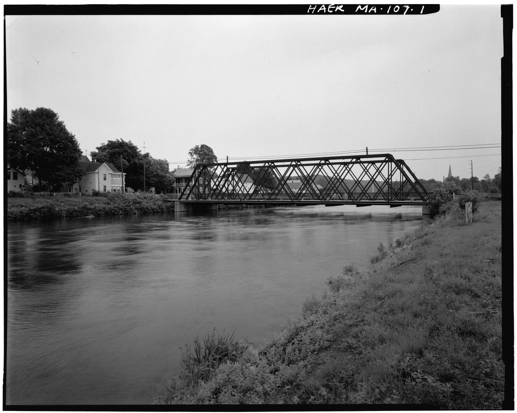
Documentation of the Eleventh Street Bridge is part of the Massachusetts Historic Bridge Recording Project, conducted during the summer of under the co-sponsorship of HABS/HAER and the Massachusetts Department of Public Works, in cooperation with the Massachusetts Historical Commission- Lola Bennett, HAER Historian, August ELEVENTH STREET BRIDGE HAER No. MA-107 (page 2) Description The Eleventh Street Bridge is a triple-barrel, 167-foot, riveted steel double-intersection Warren through truss. The main configuration is a central roadway barrel with no overhead lateral bracing, with a through truss sidewalk barrel on either side. Each of the four trusses is identical.
The upper chord of each truss is comprised of two channels, connected with a plate on the upper side and lacing and tie plates on the lower side. The inclined end posts are built up in the same manner as the upper chord, except that the channels have two plates riveted to their inner faces. The bottom ends of the end posts are riveted to steel plates, which are bolted to the concrete pier at the west end of the bridges and rest on nests of rollers on the piers at the east end of the bridge. The lower chord is two angles connected with lacing. The upper and lower chords are connected by means of vertical hip posts angles connected with tie plates) at the end panel points, and by built-up diagonal members, crossing between panel points throughout the length of the truss.
The diagonals angling down toward the ends are comprised of two angles connected with a solid plate, and pass through the center of the diagonals angling up toward the ends, which are comprised of two angles connected with tie plates. The lower end of the vertical hip posts and diagonal members are attached to the lower chord and floor beams by means of riveted gusset plates. The floor system is comprised I-section steel beams and steel stringers, and corrugated steel decking, which support a poured concrete deck, and an asphalt-paved roadway, wide. On either side of the roadway is a raised sidewalk, wide, with latticed railings on the outer sides.
Above each sidewalk is overhead lateral bracing and portal bracing, consisting of two angles riveted together, connecting the outer truss and inner truss. Both ends of the bridge rest on concrete piers, with a short stringer approach span extending from pier to abutment at either end.(See field photos and copies of original plans in field file.) Early History of Turners Falls The Village of Turners Falls, the largest and most recently developed of the five villages in the town of Montague, Massachusetts, is located about two and a half miles east of the town of Greenfield, and nine miles south of the Vermont border, on the eastern bank of the Connecticut River.
At this location, the river describes a double turn, flowing to the west and northwest for several miles, then suddenly turning to the southwest for a short distance, and then finally turning once again to the south,(See Figures 1 and la.) At the point where the river makes an abrupt "hook" from north to south, it also drops sharply over a ledge of rock, at the place called Turners Falls. Originally, this spot was known as "Great Falls," and was a popular Indian fishing ground. It was renamed for Captain William Turner, who fought the Indians there in during King Philip's War.
Yet, while historic maps indicate that this place was known as Turners Falls, as early as the the village itself did not exist until the year Shortly after the close of the Revolutionary War, when internal improvements were being planned in various parts of the new nation, a group of men living in the Connecticut River Valley proposed the development of a ELEVENTH STREET BRIDGE HAER No. MA-107 (page 3) system of locks and canals on the Connecticut River at South Hadley and at Turners Falls in Montague. Until that time, transportation in the Connecticut Valley, as elsewhere, had been limited and difficult.
By the late eighteenth century, however, competition between Massachusetts and Connecticut seaport towns over control of northern New England trade created a need for unobstructed navigation on the Connecticut River.1 On February 23, the state legislature passed an act, incorporating the Honorable John Worthington Esquire, and others, for the purpose of rendering Connecticut River passable for boats and other things, from the mouth of the Chicopee River Northward throughout this Commonwealth, by the name of the Proprietors of the Locks and Canals on Connecticut River.2 Two years into the project, the proprietors realized the immensity of their enterprise, and under another act of legislature, divided their interest into the Upper and Lower Canals.
The original proprietors remained a corporation, and a separate corporation was formed, by the name of "The proprietors of the Upper Locks and Canals on Connecticut River."3 Within a few years, the project was completed, making the Connecticut the first river in the country to be improved by locks and canals.4 This canal system was one of the most popular means of transportation in the Connecticut Valley until the development of the railroad in the and for nearly half a century, the upper canal, otherwise referred to as the "Montague Canal," operated successfully. In the first steam locomotive reached Greenfield, by way of the Connecticut River Railroad.
The canal system was just no match for the railroads, and as time went on, "a larger and larger proportion of the freight of the valley was diverted to the rails."5 In just ten years after railroad tracks were laid to Greenfield, the last boat passed through the locks at Montague, and the canal was abandoned and left to decay.6 The Village of Turners Falls The development of the Village of Turners Falls began a dacade later, in That year, while searching for a more direct route to Greenfield than the one taken by the Vermont & Massachusetts Railroad, Colonel Alvah Crocker (see Figure 2), one of the leading citizens of Fitchburg, observed the falls and canal at Montague, and realized that the location had tremendous potential for water-powered industries.
The following year, Crocker organized the "Turners Falls Company," by buying and redeveloping the property and franchises of the old canal corporation. An act of legislature authorized the new company to build and maintain a dam and canal, and to lease and sell the use of water for power purposes,7 The company also purchased large plots of land in the northwest corner of the town of Montague, and set about the task of creating a great industrial city, known as "Turners Falls." Located at the crossroads of the Connecticut and Deerfield Valleys, with water-power, undeveloped land, laborers, and access to railroads in abundant supply, the development of industry at Turners Falls was destined to be a great success.
Crocker wished to see Turners Falls "rival Lowell, Holyoke and other ELEVENTH STREET BRIDGE HAER No. MA-107 (page 4) manufacturing cities in size and commercial importance, and even to excel them; and to that end he spared nothing in his wonderful genius and manifold resources."8 The first project undertaken was the construction of a dam across the river, completed in Shortly thereafter, William Crocker, Alvah's brother, was employed as engineer to excavate the power canal and plan the city.
Maps from the early show Turners Falls as it was conceived in Crocker's mind--an impressive grid of streets extending out on both sides of the main canal, with at least twenty-five mill sites lined up along its length.(See Figures 3 and 4.) The power canal, 50' wide, long and 10' deep, was dug parallel to the river. During the next decade, it was extended another to the southwest, to accomodate more mill sites.
The first industry to establish itself at Turners Falls was the Turners Falls Lumber Company, which built a sawmill at the north end of the dam and began operations in This enterprise was attracted to Turners Falls by the great river which provided power and down which logs from northern forests could be floated to the mill, and by the promise of an enourmous (sic) demand for lumber for building the factories and homes of the projected city.9 Shortly thereafter, a number of other industries were established at Turners Falls, including the John Russell Cutlery Company, the Montague Paper Company, Keith Paper Company, Shawmut Manufacturing Company (makers of imitation leather), Clarke & Chapman Machine Company, and the Griswoldville Manufacturing Company (a cotton mill).
By the village was populated with people, and in addition to the manufactories previously mentioned, contained: a fine hotel, two banks, four church edifices, two handsome and costly school buildings, a steam fire-engine company of 18 members, a weekly newspaper publication, several handsome brick business blocks, numerous stores, a public library, and many elegant private residences.10(See Figure 5.) Although the village and industries continued to grow and thrive on into the first quarter of the twentieth century, Turners Falls was never to achieve the prosperity and greatness prophesied by Alvah Crocker.
This was largely due to Crocker's untimely death in Turners Falls, it was said, was the chief ambition of Crocker's life: What he would have accomplished for the place had he been spared to test his energies to the full, no man can say; but, estimating the probable results of the future from the great achievements he had effected in the few years he was permitted to devote to the task, it cannot be denied that he would have left Turner's Falls as a splendid monument to his greatness.11 While the village of Turners Falls was never to achieve industrial greatness ELEVENTH STREET BRIDGE HAER No. MA-107 (page 5) in its own right, Alvah Crocker's development of water power there would eventually become part of a vast public utility system, one of the largest in New England.
Hydro-Electric Development at Turners Fall On June 9, A.S. Clarke of the Clarke & Chapman Machine Company, made arrangements with the Turners Falls Company for "a six-hour additional use of water," for the purpose of generating electricity at night. Soon afterward, a small company of public-spirited citizens leased water to drive a thirty-five kilowatt generator, and established the Franklin Electric Light Company.12 Eighteen years later, in Charles Hazelton, treasurer of the Turners Falls Company, proposed to the board of directors that that they make better use of the water power being wasted, by widening and extending the canal, and establishing a hydro-electric generating plant of kilowatt capacity.
His proposal met with unanimous agreement, and was carried out during the next three years.13 A few years later, an Boston investor by the name of Philip Cabot, who owned stock in the Amherst Gas Company, the Greenfield Electric Light & Power Company and the Easthampton Gas Company, purchased an interest in the Turners Falls Power & Electric Company, and was invited to become a director for all of these companies. With these companies--which basically controlled the generation and transmission of electric power in the Connecticut River Valley- -in close association with one another, Cabot proposed the development of a hydro-electric plant of kilowatt capacity at Turners Falls.
Work commenced in In Cabot and his directors decided to consolidate the Turners Falls Company and the Amherst Power Company, under the name of the Turners Falls Power & Electric Company. Through a series of further consolidations in the late and the Western Massachusetts Electric Company was formed.14 This company has most recently merged with Connecticut interests to form Northeast Utilities, one of the largest public utility companies in the region.
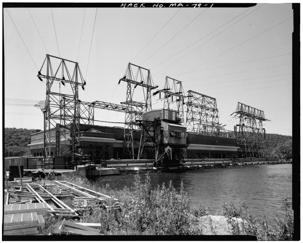
Construction of the Eleventh Street Bridge Between and the Turners Falls power canal was extended south about a mile and a half, and a huge electric generating plant, later named Cabot Station, was built.(See Figures 6 and 7.) Of this development, the local newspaper reported: The development so far as mapped out is merely the beginning of the great work of utilizing the power of the river in permanent construction, and Turners Falls will look brighter from now on in many ways. ... In the first place, a section of concrete dam will be laid close up to the present dam beginning at Great Island, in the centre (sic) of the river, and extending 330 feet toward the bulk- head.
It will be practically 30 feet high, with the usual base for height calculated for such work, and will contain somewhere ELEVENTH STREET BRIDGE HAER No. MA-107 (page 6) for height calculated for such work, and will contain somewhere between and cubic feet of masonry. This dam will back up the present dam at its weakest point, and make the whole structure of immense strength. Now the present canal will be widened from the old point of widening at the Cutlery works, to the beginning of the widened canal near the cotton mill. The new work will be east of the present canal, leaving a core of 20 feet, to be removed at a later time.
The old canal is 50 feet, and the new work will be 65 feet, making the finished canal eventually 135 feet wide, capable of carrying an immense body of water to its full depth of 18 feet. ,.. New steel bridges will be put over the canal at the Griswold mill, the lower suspension bridge crossing, the Keith mill and at the Cutlery works. The contractors will begin work in about 10 days, carrying along the railway removal and the canal together, and the whole work will be finished inside of 15 months.
When completed there will be a lot more power for sale, and it will be sold preferably to local parties to be used in manufacturing, and the President of the Company is very anxious to make every inducement in reason to parties desiring to locate here, especially small plants, and many of them, in which good wages are usually paid. The coming year's activity will stimulate business here in all lines, and will be appreciated by our many merchants and professional men. It may be the turning of the tide that is going to carry us all to fortune.15 The construction of the bridges over the canal at Sixth Street and Eleventh Street were a significant part of this project, because the extension of the power canal would, in effect, create an "island" in the center of Turners Falls.
The section of town known as the "South End" would be bordered on all sides with water--the Connecticut River on the north and west, and the power canal on the east and south--and connected to the rest of the village by only a small strip of land to the north.(See Figure 8.) While a magnificent suspension bridge spanned the river at Sixth Street, and there were several small bridges crossing the upper part of the canal, the lower section of the canal would need to be bridged between the center of town and the South End. The Sixth Street Bridge was constructed across the canal in It was a riveted, double-intersection Warren through truss, designed by the Eastern Bridge & Structural Company of Worcester, and erected by a crew of workers from the Turners Falls Company.
The bridge crossed the canal at a point where it directly lined up with the suspension bridge to Greenfield. Adjacent to the bridge, on the northeast side, a smaller pedestrian bridge was erected at the same time. The pedestrian bridge was of a similar configuration as the vehicular bridge, but smaller in scale.(See Figure 9.) Documentary evidence for the Eleventh Street Bridge seems to indicate that it was originally designed to be very similar to the bridge at Sixth Street. The original plans for the bridge, drawn up by the Eastern Bridge & Structural Company in May of show a double-intersection Warren through ELEVENTH STREET BRIDGE HAER No.
MA-107 (page 7) truss, with a 21-foot wide roadway, upper lateral bracing, and no sidewalks.(See Figure A second set of plans for the same bridge, dated May, shows a pair of double-intersection Warren trusses on either side of a roadway 27 feet wide, with a 6-foot wide sidewalk running between each pair of trusses. Rather than the standard upper lateral bracing over the center barrel, the second set of plans shows lateral bracing only over the sidewalk barrels. The two inner trusses are referred to, on several of the sheets, as "old trusses," with a job number that refers back to the first set of plans.(See Figure Why did this change in plans occur?
Even after a considerable amount of research, there does not appear to be a conclusive answer, but apparently, some discrepancy arose between the Turners Falls Company, which was paying for the bridge, and the residents of the town, who were the beneficiaries of the whatever infrastructure changes the company were required to make.
On October 23, at a town meeting, the town voted: that the bridge to be built across the new canal at Eleventh Street in the Village of Turners Falls shall have a roadway of not less than thirty feet in the clear, it shall have two side- walks one on each side, each walk shall be six (6) feet in the clear, with suitable guard on the outside of such walks to prevent children from falling from bridge into the canal and that the town of Montague demand that the bridge be built by the Turners Falls Company as mentioned above ... and that the council for the town be and is hereby authorized and instructed to take such legal action as may be necessary to protect the interests of the town in the matter of building a bridge across the new canal at Eleventh Street.
16 A few months later, on March 25, that vote was rescinded, and another vote was passed, authorizing the Turners Falls Company "to construct a steel bridge across the new canal at Eleventh Street in Turners Falls which shall have a roadway twenty-seven feet in width and one (1) sidewalk six (6) feet wide on each side of the said roadway."17 At the same meeting, a committee of five citizens of the "South End" was chosen, to act with the selectmen in approving the plans for the bridge.18 Clearly, there was some discrepancy between what the Turners Falls Company had made plans for, and what the town felt it needed. While this suggests the general basis for the changes in plans for the Eleventh Street Bridge, there are apparently no written records as to the specifics of those changes.
The original plans called for a narrow bridge (21 feet wide), with no sidewalks; the later plans showed a much wider bridge (27 feet wide), with a 6-foot sidewalk on either side. While this change could have been made quite easily on the drawing board, a considerable amount of time had passed since the initial plans were drawn up, and the reference on the drawings to "old trusses" indicates that they had already been fabricated, and perhaps even shipped to the site by that time. Increasing the size of the bridge and adding sidewalks meant that the already-fabricated trusses would have had greater dead and live loads to carry, probably more than they could bear.
Instead of designing and fabricating a new bridge and scrapping the old, which could have been quite ELEVENTH STREET BRIDGE HAER No. MA-107 (page 8) costly, the engineers apparently decided to increase the load-carrying capacity of the old trusses by adding two identical trusses to the design. Once that was done, and the width of the bridge was increased, new lateral bracing was necessary. By spanning the shorter distance between the outer and inner trusses, rather than the entire distance between the two outer trusses, the strut sizes could be considerably reduced. As finally constructed, the Eleventh Street Bridge represented a unique engineering solution to a project influenced by both public and private interests.
The Eleventh Street Bridge was erected according to the second set of plans and specifications, during the early summer of In May, the local newspaper stated: Work has commenced erecting the superstructure of the new bridge over the canal at Eleventh Street. The work will probably require two or three weeks to finish, and in the meantime the street is closed to all but pedestrians. Other travel has to go around the I street bridge to get to South End.19 Four weeks later, the bridge was finished, and this item appeared in the Greenfield newspaper: "The bridge over the canal at street was completed this week by the Eastern Bridge and Const.
Co."20 A photo, taken during construction of the canal extension, shows the bridge exactly as it appears today.(See Figure At each end of the bridge is a plaque, bearing an inscription. The plaque on the east end reads: Built by the Turners Falls Company for the Town of Montague Fred C. Haigis Michael J. Carey Selectmen Lester T. Bartlett Eastern Bridge & Structural Company Manufacturers, Worcester, Mass. The plaque on the west end bears the names of the bridge committee: Daniel Shanahan, Fred J. Treml, Thomas R. Casey, A.J. Nims, and Thomas Ducharrae. The Eleventh Street Bridge is still in use today as the only vehicular and pedestrian bridge in Turners Falls' South End.
It is significant as a unique configuration of a double-intersection Warren through truss, and is the unique result of a project in which political factors played a major role in the final appearance of the structure. The bridge is also a significant artifact of the development of hydro-electric power in western Massachusetts. The bridge fabricator, Eastern Bridge & Structural Company, was an important regional bridge-manufacturing company in the early- to mid-twentieth century. Eastern Bridge & Structural Company The Eastern Bridge & Structural Company was established in by Ralph H. Brown and A.S. Miller, Jr. Prior to that time, the two men had been ELEVENTH STREET BRIDGE HAER No.
MA-107 (page 9) associated with the Boston Bridge Works (see HAER report MA-103), but eventually decided to form their own company.21 With the help of some Worcester investors, the founders purchased an old car barn on Crescent Street in Worcester, and began manufacturing structural steel for buildings and bridges in March of Eastern Bridge & Structural Company was listed in Worcester city directories, under the heading of "Bridge Builders," beginning in Ralph H. Brown was listed as chief engineer from until his death in A. Sherman Miller Jr. was listed as treasurer from until at which time, John C. Stewart, of Stewart Boiler Works, took over as president and treasurer of the company.
Over the years, the company grew from 50 employees in to 200 employees in expanded their plant from square feet, to square feet; and increased their output from 300 tons of steel each month, to tons of steel each month.23 According to city directories, the name was changed in to "Eastern Bridge Company." In a branch company was added, known as "Eastern Bridge Supply Company," which sold builders materials, masons supplies, and insulation and roofing materials. Both companies were listed in city directories until after which only the supply company was listed. The last listing for the supply company was in the Worcester city directory. ELEVENTH STREET BRIDGE HAER No. MA-107 (page 10) bO C H so ^c 03 CO r-* * i-4 ^~v Q O r-.
CO i i )-( 0) - c w u u 3 Q) H 0) CO *w O 3 0 tb T-l ' u i-.f .-< 'vrsii4,^ \|W ' > i ', v * CO u y 0 4-) rH <y Ul o 3 JS to c o u (A 4) w > CO ^ E C^ _ 4J vtX yyi-..:^f''f ']p-%if^ ^^ L$ -$ .A^jfi i-z v f J ~ -v - - " >. 3 u O t ; c H 3 *J O O o <u c c c w o 1 t o ^ cCO X0) !-< *J Pti -Z U-t M-t o o a> -i a a, CO CO u s 3o o r-< a) li.^>-^^^| ^UL^__,i^--^ J5 a) 4J M 3 UH ij sorter - * ?- ELEVENTH STREET BRIDGE HAER No. MA-107 (page 11) Turner's Fills Business Notices. Muilxiinn. SOAM. u>o/tat .? t* tJix. inek. U mui.xit or.,ifaiiM<iCi'>T niaiirii|i>'-ib Btrtnnar.fhMitBMiltMUtWTllihh B*U**t H.. Kit*** **4 0 ail%**r. Ut HI tt . r. .Cirtl lofiiwr ud hmm EOVTI. D..JabbHr IbinLudlilia OwlL L.D^Hli 1* MOiwnfe Una, (tam nd c> i BuJAiM HtwfUl VQbAi r.rVvt-tiMi Ota* ^ O 11f LIXS & #?
8& < I ^ SI** fc v- 'AGrEClTYEO. Jt.R.Am*wr*t ^t+.AM/tnrH-x ^;fe ' '(Jl.ZvrtltatS "-st-i 'JMTi* -s / r*r r.B*irrUi/tni- ffirmJiwrt U < I. frfi-H, . f * \ ^ -.- ~c- ^ - * \w > Figure la. Map of Montague, Massachusetts Beers, showing location of Turners Falls. ELEVENTH STREET BRIDGE HAER No. MA-107 (page 12) t^^W&Z*^&^^^a Figure 2. Portrait of Alvah Crocker (Hurd, ELEVENTH STREET BRIDGE HAER No. MA-107 <page 13) O GO u 0) 3 b <D c 1-1 . H iw O u O o (A o a o u 0 a ELEVENTH STREET BRIDGE HAER No. MA-107 (page 14) 4 ." < ' / \^IV%^->\M i e i ' til r-. 0) u o '-I U 3 effigy- w u <u c H OQ o ? 1 w b r-l I [ CO 0) M 3 bO En
No. MA-107 15) CO w U > 0) CO W u c V-i H O 0) 0) I CO l-f tn 0) u GO t*4 ELEVENTH STREET BRIDGE HAER No. MA-107 (page 16) >-, a - C CO fl O, r-t CTs eo r-l o .. o W f* . f V-i i 1 w nj o U-, o i-4 01 to] M a) W C 4J W 4-) 3 0) H W 3 4= O o CO C to ca U) * i cO CM s: X c a>i-l T3 a) C 4-) i < W s ai 3 4-t ^D O 0) >i Vi M 3 (1) bO 4J TH H &M 3 o o ELEVENTH STREET BRIDGE HAER No. MA-107 (page 17) y3 J u. ^~s W c ^n u o r-t 0> t-t a e u i-t 1-1 (0 3 u H w u 4J n) 0 >i .O r-i u cfl 3 c U n 0) S O - a i_) o 3 r-i t-J <u a) CO z ? c a> J ot T3 u H y tw ^ i-i 0 <u u <u u e c o o *4 $> > -4 6J w en c a) c w 0) o JJ c u X H o <U >-. T3 J= bO V C . n H w o 3 1-4 <M O r-< J= XI c en 3 cd CM CU 3. ELEVENTH STREET BRIDGE HAER No.
MA-107 (page 18) a qrs Map* Greenfield, Massachusetts, Quad., showing the "i^d"'of Turners falls South End and the Eleventh Street Bridge. ELEVENTH STREET BRIDGE HAER No. KA-107 (page 19) >, - o "^ i-> - 4 CJ :_ 0) r**i . < us u 0) CD M u u r 4~i o .n VI ^ * * *-- i * ' o X c .-^ vl on vl U-j r: o u 4-1 0 0 w ^ 71 OS >, u -j, Z cv ELEVENTH STREET BRIDGE HAER No. MA-107 (page 20) i; -w^'/'A': iJiX^t^r f. r *i 1 !' :. ; -' *" 'iV? ," - ' > 'v.v^'vavv,,'(v-:;'.,".';'' ; :> ' t'Ci' .-- ''' ''- -.- = ^: A- ' li'i.:''. ". -- ..- : ) > . cT 1 1 - . ' -: II;;V-:..^M : ' 4> no " ' ' * \\ : ": .: r~H 1-1 u <D 0> U u CO J2 4J C > r-l faJ 1-1 o c r-l a CH n) C H H U O 01 J-l to ELEVENTH STREET BRIDGE HAER No. MA-107 (page 21) ;". iO 1 <-i O .' t-l " . * <1> i ' b0 r -o r-< t: U , CQ } U m : 0 f.
\ u ', u i C/l > X i 4J c <u >. 0) i-i O c w > erf 0) fc4 ^r^^i^r^i^^^^r^ F^. ELEVENTH STREET BRIDGE HAER No. MA-107 (page 22) in 'j >- 3 = W w1 X > - U-l O o O ELEVENTH STREET BRIDGE HAER No. MA-107 (page 23) ENDNOTES 1. Edwin M. Bacon, The Connecticut River and the Valley of the Connecticut (New York/London, 2. Acts of Massachusetts. 3. Ibid, 4. Bacon, 5. John Norman Carls, "Industrial Geography of Turners Falls. Massachusetts." thesis (Clark University, Worcester, Massachusetts, 6. Ibid. 7. Acts of Massachusetts. 8. D. Hamilton Hurd, History of Worcester County, Massachusetts, vol. 1 (Philadelphia, 9. Carls, 10. Louis H. Everts, History of the Connecticut Valley in Massachusetts, vol. 2 (Philadelphia, 11. Hurd, 12. Fred C. Abercrombie, The Turners Falls Power and Electric Company.
A Public Utility since (Turners Falls, Massachusetts, p. 13. 13. Ibid, 14. Charles Sidney Severance, History of Greenfield. (Greenfield, Massachusetts, 15. Turners Falls Reporter. Turners Falls, Massachusetts, January 24, 16. Montague Town Records. Book F, October 23, 17. Ibid, March 25, 18. Ibid. 19. Turners Falls Reporter. May 26, 20. Gazette and Courier. Greenfield, Massachusetts, June 26, ELEVENTH STREET BRIDGE HAER No. MA-107 (page 24) 21. Orra L. Stone, History of Massachusetts Industries: Their Inception. Growth and Success (Boston/Chicago, 22. Ibid. 23. Ibid. ELEVENTH STREET BRIDGE HAER No. MA-107 (page 25)
Abercrombie, Fred C. The Turners Falls Power and Electric Company. A Public Utility Since Turners Falls, Massachusetts, Bacon, Edwin M. The Connecticut River and the Valley of the Connecticut. New York/London: Putnam's Sons, Bailey, O.K. and Co. Map of Turners Falls, Massachusetts. Boston, Beers, Atlas of Franklin County. Massachusetts. New York: Beers and Co., Carls, John Norman. "Industrial Geography of Turners Falls, Massachusetts," thesis. Clark University, Worcester, Massachusetts, Centennial Gazette: Greenfield. Mass. Greenfield: E.A. Hall, Publisher, Clous, Richard. "The Planning and Development of Turners Falls, Massachusetts, research paper.
Cornell University, (Copy on file at the Carnegie Public Library, Turners Falls, Massachusetts.) Connell, "The Hydroelectric Development of the Turners Falls Power & Electric Company at Montague City, Mass.," General Electric Review, vol. 20 no. 3 (March Crane, Ellery Bicknell. "Alvah Crocker," biographical sketch, in Historic Homes and Institutions and Geneological and Personal Memoirs of Worcester County, Massachusetts, vol. 4, New York: Lewis Publishing Co., pp. Crocker, William P. "Plan of the Projected City at Turners Falls in the Town of Montague, Mass., September Eastern Bridge and Structural Co.
"Plans for Eleventh Street Bridge, Turners Falls." Worcester, Massachusetts, (On file at Aimer Huntley and Associates, Inc., Northampton, Massachusetts.) Engineering Society of Western Massachusetts. "Inspection of Turners Falls Power & Electric Company's Hydro-Electric Development at Turners Falls, Mass., November 22, Typescript, Northeast Utilities Service Company, Berlin, Connecticut. Everts, Louis H. History of the Connecticut Valley in Massachusetts, vol 2. Philadelphia: Lippincott and Co. Press, Greenfield Gazette and Courier. Greenfield, Massachusetts. ELEVENTH STREET BRIDGE HAER No. MA-107 (page 26) Hayward, John. A Gazetteer of Massachusetts. Boston: John Hayward, Hazelton, Charles W.
"Early Days of Turners Falls," historical paper read by author at Annual Meeting of Pocumtuck Valley Memorial Association held at Deerfield, Feb. 23, (Copy on file at the Carnegie Public Library, Turners Falls, Massachusetts.) Historic Photo Collection: Construction of Turners Falls Canal Uncatalogued. Western Massachusetts Electric Company archives, Greenfield, Massachusetts, Holland, Josiah Gilbert. History of Western Massachusetts. 2 vols. Springfield: Samuel Bowles and Co., Hurd, D. Hamilton. "Alvah Crocker," biographical sketch, in History of Worcester County. Massachusetts, vol. 1. Philadelphia: Lewis and Co., pp. "Index Plan of Turners Falls," Real Estate Titles: Turners Falls Co.--The Montague Co., Aug. 15. Uncatalogued bound volume.
Western Massachusetts Electric Company archives, Greenfield, Massachusetts. "Largest Hydroelectric Plant in New England," Electrical World, vol. 69 (June 21, Lockwood, Rev. John H. , and others. Western Massachusetts, A History 4 vols. New York: Lewis Historical Publishing Co., Nason, Elias. A Gazetteer of the State of Massachusetts, revised and enlarged by George J. Varney. Boston: Russell, Pressey, Edward Pearson. History of Montague. A Typical Puritan Town. Montague, Massachusetts: The New Clairvaux Press, Severance, Charles Sidney. History of Greenfield. Greenfield, Massachusetts: Town of Greenfield, Stone, Orra L. History of Massachusetts Industries: Their Inception. Growth and Success.
Boston/Chicago: The Clarke Publishing Co., Telephone Interview with Lionel Girard, Turners Falls historian, July 16, Telephone interview with Winslow Wentworth, Turners Falls historian, July 11, Town of Montague Annual Reports, Turner, Howard M. "Hydraulic Redevelopment at Turners Falls, Mass.," Engineering News vol. 74 (July 29, ELEVENTH STREET BRIDGE HAER No. MA-107 (page 27) Turners Falls Reporter. Turners Falls, Massachusetts. Warner, Charles F., ed. Picturesque Franklin. Northampton, Massachusetts: Wade, Warner and Co., Publishers, Worcester Citv Directories. Wheelwright, William Bond. Life and Times of Alvah Crocker. Boston: privately printed,
 Block
Block