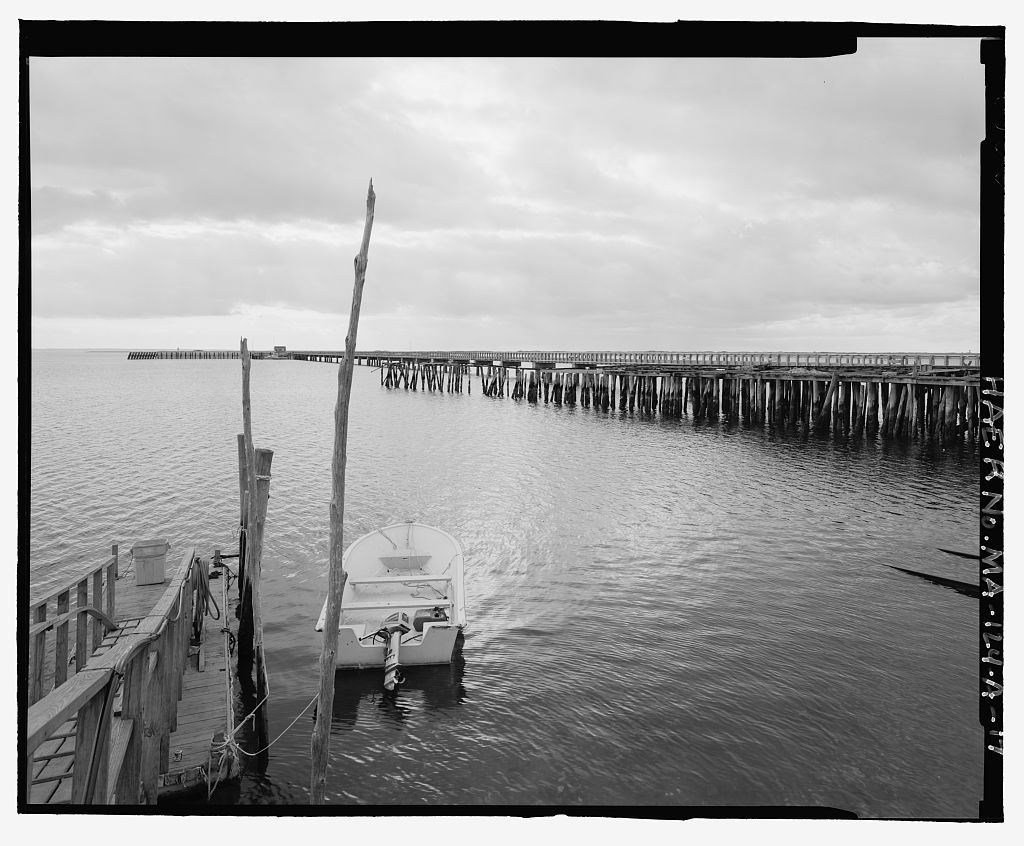
Due to advanced deterioration, serious navigational and safety hazards and the abandonment of its use for trap fishing, the structure has been scheduled for demolition. To mitigate the adverse effect, the State Historic Preservation Office stipulated documentation of the structure, as well as the retention of nearly half of the existing pilings. Richard C. Youngken The Newport Collaborative, Inc. 14 Pelham Street Newport, RI CAPE COD COLD STORAGE, FREEMAN'S WHARF (U.S. Coast Guard Station Provincetown) HAER No. MA-124-A (Page 2) Freeman's Wharf is located in the western portion of Provincetown Harbor on the southern shore of the tip of Cape Cod facing a semi-protective embayment of the harbor.
This area of the harbor is shielded, in part, by a breakwater to the east and by a spit of land to the southwest. Description of Wharf Structure The structure is supported by a varied system of multiple peeled whole log timber piers, sawn timber pier caps or plates, sawn wood floor joists and wood decking, much of which is in an advanced state of deterioration. From land, the structure is approached via a bituminous asphalt service road and parking area located within the confines of the U. S. Coast Guard Station, Provincetown, to the east of the Station House. Freeman's Wharf is a timber wharf which is a remnant of an extensive structure which extended approximately feet into the harbor perpendicular to the shore.
This remnant includes approximately 3 60 feet of pilings, stingers and decking, supported by a dense massing of whole log posts apparently imbedded 30" in the sand within wood stave baskets. There are over 860 posts in various stages of decay supporting the wharf. Much of the structure is in serious danger of collapsing into the harbor. The remaining portions of the wharf decking surface are unsafe to walk on. Some of the structure consists of century spar and joist construction. A wood-framed story wharf building, known as the trap shed was demolished and removed from Freeman's Wharf in Extending from the trap shed southward to the end of the wharf is the remains of a narrow gauge rail system of two steel rails supported by wood ties.
Successive storms and ice in the harbor have removed approximately 375 feet of the southern portion of the wharf since The extant wharf structure is constructed of various sawn wood stringers supported by numerous peeled log posts and it is decked in varying sizes of wood planking. It has a superficial appearance as a single structural unit. The structure is, however, composed of several distinct structural parts which retain individual framing design, decking configuration and are individually representative of specific functional uses during the period of significance. For the purposes of this description the wharf will be broken into three distinct functional units, the wharf apron, the trap shed area and the railbed pier. CAPE COD COLD STORAGE, FREEMAN'S WHARF (U.S.
Coast Guard Station Provincetown) HAER No. MA-124-A (Page 3) Wharf Apron The framing system of the wharf apron indicates that the eastern portion of this section of Freeman's Wharf was utilized for heavy loading. Under this area, heavy pier plates composed of three approximately members bolted together in a composite are supported by multiple peeled log posts. These heavy stringers extend southward approximately on center. This support system indicates that the eastern portion of the wharf may have been used for the motorized transport of supplies from the trap shed area to land approximately 50 feet north of the wharf.
Remnants of posts imbedded in the sand immediately to the southwest of the wharf apron and historical photographs are an indication that in this location, a framework supported an aerial monorail tramway from the trap shed to the cold storage facility (no longer extant) on land nearby. Trap Shed Area The trap shed area is a widening of the wharf southeast of the wharf apron. The framing system of the area in which the trap shed was located is constructed of lighter members than the surrounding areas. Sawn plates are supported by 8" diameter log posts in this area. Supported by the plates are sawn and notched joists, on center. These joists support the light floor deck boards of the trap shed floor. The notched j oists are evidence of interior partition framing.
The trap shed did not house heavy machinery. The rail system enters through the southeast end of the trap shed area and extends within the building footprint along the southwestern side, ending short of the northwestern end of the building. A shut opening in the deck allowed fish to be dumped from the cart into a tramway hopper. An aerial tramway extended from the trap shed to the cold storage plant directly to the west, entering the plant on the 4th floor. Directly to the northeast of the trap shed footprint, the heavy composite plates or stringers extend southeasterly to the third distinct remaining component of the wharf, the railbed pier. Railbed Pier Extending southeasterly from the trap shed area is a narrow 10 foot wide pier.
Supported by multiple whole log posts and single stingers or plates, this badly deteriorated component of Freeman's Wharf is presently held together by the steel rails of the rail system. The principal function of the railbed pier was to allow for space for the rail system on the southwest side of the pier and space on the northeast side for pedestrian travel. The railbed pier originally extended approximately 760 feet southeasterly from the trap shed area to a landing platform at the end of the wharf. Historical photographs indicate that the end of the wharf was CAPE COD COLD STORAGE, FREEMAN'S WHARF (U.S. Coast Guard Station Provincetown) HAER No.
MA-124-A (Page 4) utilized as an off-loading space for fish transported from the fish traps nearby in the harbor by small boats and specialized trap fishing boats. This area of the wharf is no longer extent, although some remnants of pier posts may exist on the harbor floor in the vicinity of a landing platform at the harbor end of Freeman's Wharf. Historical photographs indicate that this area consisted of a wider deck area for a lift apparatus or crane for off-loading fishing boats moored at the end of the pier. Functional description of Wharf Freeman's Wharf was developed in its foot configuration as a functional element of a cold storage operation.
Off-loading of fish from trap fishing occurred at the outermost portion of the structure with transport of fish to the trap shed area via a gasoline-powered cart. A monorail tramway existed on the southwest side of the trap shed, rising on a skeletal framework of piers, joists and braces to enter the cold storage building at the 4th floor level. Loading of the monorail tram took place at the southeast end gable of the trap shed in the vicinity of an existing shut. This loading operation presumably entailed some sorting of the fish catch with the shut channelling discards into the harbor and/or fish into the tramway hopper. The cold storage building consisted of a multi-story structure and was used as the principal processing, freezing and storage facility at the site.
Once entering the cold storage building, the fish would be sorted onto conveyor belts for heading, filleting freezing, packaging and storing, passing through the facility downward from the entry point for each function. The trap shed on the wharf was primarily used for storage and re-tarring of nets. A tar vat was located on the landward, northwest end gable of the trap shed building. Here nets were first poisoned to prevent deterioration from animal ingestion and tarred. The interior space of the trap shed contained a toilet, and a large room with a wood stove and an area for shelter and rest. A loft space above the this room provided storage space accessible via large exterior loft doors.
Historical evolution of Wharf The history of Freeman's wharf and the associated business pursuits that occurred nearby is integral to the history of Provincetown as a prominent New England fishing port during the and early 2 0th centuries. The developmental history of the wharf can be divided into three distinct phases: early salt fishery and commercial wharf, trap fishery wharf and the Cape Cod Cold Storage, and abandonment, partial demolition and replacement with United States Coast Guard facilities. CAPE COD COLD STORAGE, FREEMAN!S WHARF (U.S. Coast Guard Station Provincetown) HAER No.
MA-124-A (Page 5) Early salt fishery wharf The evidence of the developmental evolution of Freeman's Wharf begins with early century mapped references to a small wharf and associated structures in the vicinity of the current structure. Attributed to ownership by E. Freeman, this early development included a pier for fishing and commercial landing purposes. By the late century, following construction of Commercial Street in the Freemans: E. Freeman, P. Freeman and Freeman (Francis M. Freeman) had developed a substantial 600 ft fishing wharf, with Commercial Street providing direct vehicular access. This first phase of development is based upon Provincetown's salt fishery.
During this period, there existed along the Provincetown waterfront an extensive collection of wharfs and piers, primarily used for the support of the fishing industry. By there were upwards of fifty wharfs in Provincetown Harbor. The fisheries that these facilities supported, beginning in the early century and continuing to the late century, included: o In-shore salt cod fishing, at first in Cape Cod Bay, and later in The Labrador o Off-shore salt cod fishing on The Grand Banks o In-shore mackerel fishing o Whaling The salt cod fishery was the largest of these. The Labrador codfishery of the early part of the century was substantially replaced by the Banks codfishery after 182 5.
Expansion to the Grand Banks essentially followed codfish availability, the inland codfishery having been depleted by the pollution of alewife breeding stream areas which provided a primary source of food for the codfish in these waters. Support facilities developed on shore included: ship stores; warehouses; wharfs; piers; fish flakes, fish yards or drying yards; salt works and windmills for pumping water, loft buildings and the homes of fishermen. Freeman's wharf, during this period was the support base for the Freemans' fleet of mackerel and cod fishing schooners. In Francis M. Freeman owned eight (8) fishing vessels, one of which had been cod fishing that year in the Bay of St. Lawrence (known as the Bay), the rest were employed mackerel fishing.
Freeman was a fisherman, merchant and vessel outfitter. CAPE COD COLD STORAGE, FREEMAN'S WHARF (U.S. Coast Guard Station Provincetown) HAER No. MA-124-A (Page 6) and also sold insurance. Freeman's wharf was the support base for Freeman's retail commercial, outfitting, and fishing business activities. Trap fishery wharf and cold storage Enlargement of Freeman's wharf and the development of the Cape Cod Cold Storage nearby is attributed to Joshua Paine in the early century (about This development follows possible destruction of portions of the wharf in the Portland Gale of This storm destroyed the nearby Union Wharf. The Paine Wharf stood between Freeman's Wharf and Union Wharf according to a local source.
Development of nearby Freeman's Wharf by the Paines in the early 2 0th century was possibly a result of business expansion plans associated with the advent of technology to prepare frozen fish deliverable to markets off the Cape via railroad freezer cars. The first Provincetown cold storage frozen fish operation was developed in with the establishment of the Provincetown Cold Storage. Coinciding with technological advances in anhydrous ammonia absorption freezing, trap fishing became a primary Provincetown fishery. The earliest mechanized freezing technology on the Cape was developed by Magnus J. Paulsen of Gloucester, Massachusetts in and Trap fishing was first inaugurated in Provincetown by Yankee entrepreneurs in the mid-19th century.
Trap fishing, as opposed to the vessel fishing, consisted of the entrapment of migratory fish in-shore in fish weirs or traps. These were made of posts driven in the sandy harbor and inshore bottom from which weighted nets were hung to form, box and cello-like enclosures. It was not fully developed as a profitable fishery until the period when bait fish became a profitable market. The so-called "Fishery Question" concerning Canadian enforcement of the Treaty of during the mid-1880s precluded the popular Canadian supply of bait fish to American schooners fishing for cod. As a result, trap fishing for bait became a sought after alternative. With the advent of railroad transportation from Provincetown to urban markets in fresh fish became a sought after commodity as well.
By the end of the century Provincetown's salt cod fishery was largely replaced by fresh fish and trap fishing. The development of the Cape Cod Cold Storage by Joshua Paine at Freeman's Wharf area generated significant change to the wharf, itself and adjacent land-based structures. It is from this period of development that the configuration of the wharf; wharf apron, trap shed area, and railbed pier, originates. These sections of the wharf appear to have been developed on sections of the earlier century spar and joist structure developed for by the Freemans. They were added to accommodate the functional elements appropriate for a conventional cold storage operation of the CAPE COD COLD STORAGE, FREEMAN'S WHARF (U.S. Coast Guard Station Provincetown) HAER No. MA-124-A (Page 7) period.
The reconfigured and extended wharf allowed for the off- loading of fish from nearby fish traps (in Provincetown harbor) or from fresh fishing schooners at low tide. Fish were transported by a gasoline powered cart (using a Model T engine) on the narrow gauge rail bed to the vicinity of the trap shed on the landward end of the wharf and then transported by aerial tramway into the cold storage building for processing into package^] ready-for-market frozen fish fillets. Loaded into freezer compartments, the fillets were then transported by rail to inland markets. In addition to the Provincetown Cold Storage and the Cape Cod Cold Storage, five (5) cold storage facilities were constructed in Provincetown in the late and early 2 0th centuries.
By the success of the trap fishing-cold storage-frozen fish market in Provincetown culminated in the purchase of the Cape Cod Cold Storage by the Atlantic Coast Fisheries Company of New York City. The Atlantic Coast Fisheries Company was first organized in Maine in By it had gained controlling interest in the Fulton Market Corporation of Chesebro Brothers; Robbins and Robbins; N.S.Gates Company; Rogers and Company; Wilson and Barry; Burnet and Keenen, Warner and Prankard, and the Continental Fish Company. The company had opened a small experimental fish filleting plant and laboratory on Water Street in New York City in and by it had opened a state-of-the-art fish filleting and refrigeration plant in Groton, Connecticut. The company developed the trade mark "Nordic" brand.
In addition to the Cape Cod Cold Storage, this growing fish conglomerate gained control four (4) Provincetown cold storage operations: Fisherman's Cold Storage Commercial Puritan Cold Storage Commercial Colonial Cold Storage Commercial , Consolidated Cold Storage Commercial . These operations were very successful in the years preceding World War II. In Atlantic Coast Fisheries reformed as Atlantic Coast Industries, including within its portfolio of enterprises many non- fishing related companies. The corporate move away from frozen fish production reflects the demise of trap fishing and the cold storages in Provincetown.
United States Coast Guard Provincetown facility Eventual abandonment of the facilities, conversion or demolition, essentially ended the trap fishing era in Provincetown by the The Cape Cod Cold Storage property was purchased by the United States Coast Guard in following demolition of the trap shed building on Freeman's Wharf and the cold storage structures by the owner of the property, Bernard Benkovitz. CAPE COD COLD STORAGE, FREEMANfS WHARF (U.S. Coast Guard Station Provincetown) HAER No. MA-124-A (Page 8) Freeman's Wharf, however, remained standing. Lack of maintenance and subsequent deterioration have rendered the structure unsafe, unstable and in near collapse.
The structure serves no functional roll in the use of the property by the Coast Guard, nor does it have any relationship to Coast Guard facilities constructed on the property since CAPE COD COLD STORAGE, FREEMAN'S WHARF (U.S. Coast Guard Station Provincetown) HAER No. MA-124-A (Page 9)
Primary Sources DRAWINGS, SPECIFICATIONS AND RELATED CORRESPONDENCE AND RECORDS Correspondence, records, drawings of the Atlantic Coast Fisheries Company, in The Grand Banks Archives, Provincetown, Massachusetts. Atlantic Coast Fisheries Company, Provincetown cold storages building inventory, circa Dyer, John K.,CE, "Plan of Property belonging to Atlantic Coast Fisheries Corp. of NY, Cape Cod Division, Provincetown, Mass.," November, Hastings, Jr, "Atlantic Coast Fisheries Co. Cape Cod Plant, Provincetown, Mass," plan of facilities, F.B.Hall & Co., United States Coast Guard Civil Engineering Unit Plans and Drawings, correspondence in the files of the U.S. Coast Guard Civil Engineering Unit Providence, Warwick, RI.
McNulty, Nancy, Chair Provincetown Bicentennial Commission, correspondence to Rear Admiral Stewart, Commander, First Coast Guard District, re: history of Cape Cod Cold Storage/Freeman' s Wharf, Provincetown, MA, August 1, Symmes Maini & McKee, Inc., Architects and Engineers, "Site Utilities Plan, United States Coast Guard Station, Provincetown, Massachusetts," Coast Guard DWG L-4 Sheet 56 of 74, Cambridge, Symmes Maini & McKee, Inc., Architects and Engineers, "United States Coast Guard Provincetown, Massachusetts, with Schofield Brothers Inc, Land Surveyors (of Orleans, MA), Site Demolition Plan," Coast Guard DWG L-2 Sheet 3 of 74, Cambridge, U.S Coast Guard Providence, RI, Civil Engineering Unit, "Freeman's Wharf Demolition, Station Providence.... Site Plan," Drawing No.
Sheet 1 of 2, 9- CAPE COD COLD STORAGE, FREEMAN'S WHARF (U.S. Coast Guard Station Provincetown) HAER No. MA-124-A (Page 10) PHOTOGRAPHS Photographs of the Cape Cod Cold Storage and Freeman's Wharf in The Grand Banks Archive, Provincetown, Massachusetts. Secondary Sources MAPS "Bird's Eye View of the Town of Provincetown, Barnstable County, Mass," perspective drawing, A. F. Peele, Del., Hood, Washington, "A Map of the Extremity of Cape Cod including the Townships of Provincetown and Touro with a Chart of their Sea Coast and Cape Cod Harbor, State of Massachusetts, Executed under the direction of Maj or J. D. Graham, U.S. Top. Engs. during portions of the years and plan reduced from original (in the Bureau of U.S.
Topographic Engineers, Washington, "Provincetown, Mass," perspective drawing, Walker Lithograph and Publishing Co., Boston, MA, "Village of Provincetown, Mass," reproduction of map, - Walling, Henry F., detail of "Provincetown Village," MANUSCRIPTS Bryant, George D. , "The Port Of Provincetown The Grand Banks Archive, PUBLICATIONS , Documents and Proceedings of the Halifax Commission, Vol II, Government Printing Office, Washington, DC, , "Science and Engineering Build a Big Fish Business," in Fishing Gazette.Review Number, CAPE COD COLD STORAGE- FREEMAN'S WHARF (U.S. Coast Guard Station Provincetown) HAER No. MA-124-A (Page 11) Bryant, George, "Industrial Archeology of the Cold Storage Era," in Provincetown, 250 Years. Provincetown Historical Association, Inc.
, Provincetown, Mass., Goode, George Brown, The Fisheries and Fishery Industries of the United States, Government Printing Office, Washington, DC, Sainsbury, John C. , Commercial Fishing Methods, 2nd Edition, Farnham, Surrey, UK, Wainwright, Wainwright J., Provincetown in Picture and Story, The Picture Book Company, Cotuit, MA, CAPE COD COLD STORAGE, FREEMAN'S WHARF (U.S. Coast Guard Station Provincetown) HAER No. MA-124-A (Page 12) SKETCH PLAN OF CAPE COD COLD STORAGE FACILITIES, circa < U o o w N O W$- Source: Hastings, Jr, "Atlantic Coast Fisheries Co. Cape Cod Plant, Provincetown, Mass," plan of facilities, F.B.Hall & Co., CAPE COD COLD STORAGE, FREEMAN'S WHARF (U.S. Coast Guard Station Provincetown) HAER No.
MA-124-A (Page 13) DETAIL OF SITE CONDITIONS, CAPE COD COLD STORAGE, 5-5U ** -. & is* Is IS* Source: Symmes Maim" & McKee, Inc., Architects and Engineers, "United States Coast Guard Provincetown, Massachusetts, with Schofield Brothers Inc, Land Surveyors (of Orleans, MA), Site Demolition Plan," Coast Guard DUG L-2 Sheet 3 of 74, Cambridge, CAPE COD COLD STORAGE, FREEMAN'S WHARF (U.S. Coast Guard Station Provincetown) HAER No. MA-124-A (Page 14) DETAIL OF COAST GUARD FACILITIES PLAN,
Source: Symmes Maini & McKee, Inc., Architects and Engineers, "Site Utilities Plan, United States Coast Guard Station, Provincetown, Massachusetts," Coast Guard DUG L-4 Sheet 56 of 74, Cambridge, CAPE COD COLD STORAGE, FREEMAN'S WHARF (U.S. Coast Guard Station Provincetown) HAER No. MA-124-A (Page 15) DETAIL OP FREEMAN'S WHARF DEMOLITION PLAN, Source: U.S Coast Guard Providence, RI, Civil Engineering Unit, "Freeman's Uharf Demolition Station Providence.,.. Site Plan," Drawing No. Sheet 1 of 2, ' nation ADDENDUM TO: HAER MA-124-A CAPE COD COLD STORAGE, FREEMAN'S WHARF HAER MASS,1-PTOWN,3A- (U.S. Coast Guard Station Provincetown) Commercial Street Provincetown Barnstable County Massachusetts FIELD RECORDS HISTORIC AMERICAN ENGINEERING RECORD National Park Service U.S.
Department of the Interior C Street NW Washington, DC
 Block
Block