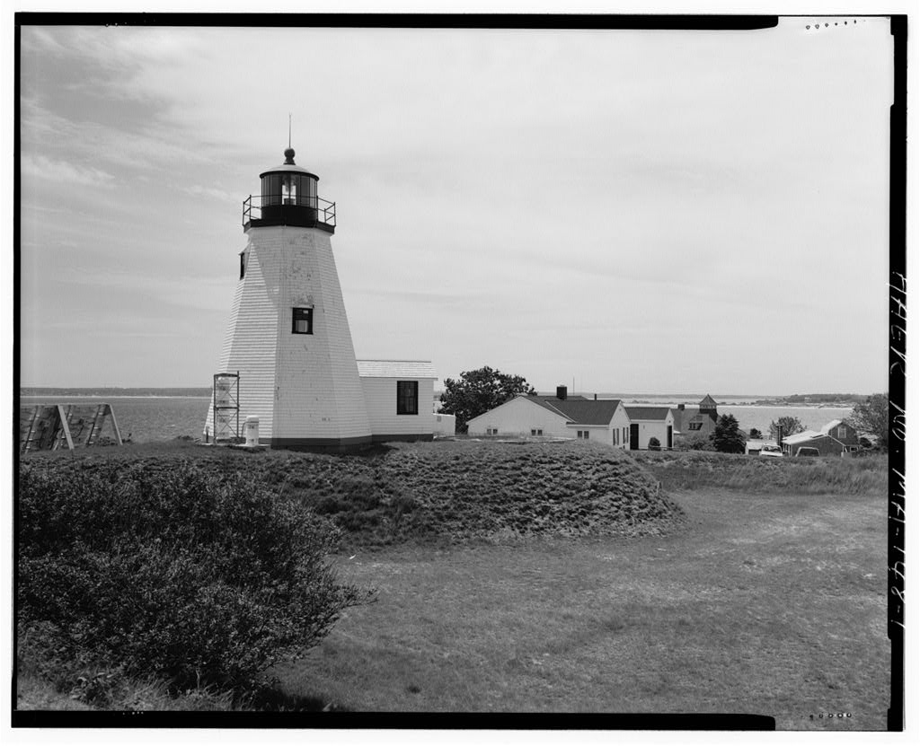
1 photograph from the federal survey record, Library of Congress.
Location
40 words
Source document
Quoted word for word from HAER MASS,12-PLYM,33-.
Not written, edited or summarised by this site.
Gurnet Point, Plymouth, Plymouth County, Massachusetts USGS Duxbury MA Quadrangle Universal Transverse Mercator Coordinates: Datefol of Construction: Engineer, etc.: unknown Present OwnerCs): United States Coast Guard Aid to Navigation Team Boston 427 Commercial Street Boston, MA Present Occupantfsl: Unmanned facility
Significance
1051 words
The headings the report itself prints. Each one jumps to where it begins.
Source document
Quoted word for word from HAER MASS,12-PLYM,33-.
Not written, edited or summarised by this site.
Plymouth Light, built in is significant as the oldest timber- framed lighthouse in the United States. It is located on the Gurnet, a strategic coastal location that has been the site of fortifications manned during the Revolutionary War, the War of the Civil War, and World War II, and was also the site of a U.S. Coast Guard life saving station. Project Information Statement: The United States Coast Guard (USCG) proposes to move Plymouth Light, a property listed in the National Register of Historic Places, 13 5 feet northeast in response to ongoing coastal erosion. The proposed project will have an adverse affect on this historic property.
In accordance with an agreement between the United States Coast Guard and the Massachusetts State Historic Preservation Office (SHPO), Historic American Engineering Record documentation was to be prepared for Plymouth Light prior to its relocation. Matthew A. Kierstead, Industrial Historian The Public Archaeology Laboratory, Inc. 210 Lonsdale Avenue Pawtucket, Rhode Island i PLYMOUTH LIGHT HAERNo.MA-148 (Page 2) PART L
Descriptive Information
Plymouth Light is located on the south ramparts of Fort Andrew, at the extreme southeast edge of the Gurnet, a high glacial till headland on the north side of the mouth of Plymouth Bay. A modern lighthouse keeper's dwelling is located several dozen feet to the northwest, outside the fort ramparts, and the Gurnet Point Observation Station, a World War II coastal defense structure, is located several dozen feet to the east. Plymouth Light is octagonal in plan and tapered in section, giving it a "saltshaker" profile. It measures 39 ft high and 20 ft across at the base. The three-story structure rests on a low, quarry-faced, granite block foundation. The sides are sheathed in closely-spaced shingles, painted white.
A one-story, side-gabled, shingle-roofed ell extends to the north, with a modern paneled wood entrance door located in the west elevation, and a multi-pane, double-hung, wood-sash window located in the east elevation. This ell originally served as entrance to a second tower, no longer extant. The granite block foundation of the second tower is still in place to the north. The first floor is lit by a window on the west elevation, the second floor is lit by a single window located on the east elevation, and the third floor is lit by a similar window in the south elevation. Each window is sheltered by a tall, sloping, shingled awning. The top of the tower is marked by a simple, shallow cornice with a metal pipe railing.
The lantern is set back from the cornice and encircled by a narrow deck with a plaque marked" " on its north edge. The lantern is cylindrical, with multiple vertical panes of glass set into metal mull ions and has a shallow, conical metal roof with a spherical decorative finial ventilator with a tall lightning rod. There is no access to the lantern from inside the lighthouse; the lantern is reached by placing a ladder against the northwest side to reach a short metal ladder mounted to the edge of the deck where there is a gap in the railing. The tower interior is divided into three floors, connected by a simple, railed wood staircase. The structural system consists of heavy, notched and pegged, hand-hewn and band-sawn, timber framing.
Eight inclined posts rise from the angle points of the foundation to the lantern base, which consists of eight short, horizontal radiating beams joined at the center of the structure. This structural system is stiffened with timber X-braces located in the panels between the inclined posts. The structural system supporting the second floor consists of four large beams arranged in two parallel pairs and intersecting at right angles. The ends of the beams are notched into the inclined posts, and the staircase penetrates the floor in the square area at the center of the floor beam structure. A modern fog horn is located at the base on the southeast side of the lighthouse, and a solar panel array is located approximately 20 feet to the southwest.
The poured concrete foundation of an electrical generator house, no longer extant, is located to the northwest. PARTn.
Historical Information
Plymouth Light, built in is primarily significant as it is the oldest standing timber-framed lighthouse in the United States. When originally constructed, mis aid to navigation perpetuated the tradition of twin lit beacons at this site, and had two identical, attached towers. The second tower, originally located immediately to the southwest, was removed in as part of navigation improvements for increased coastal marine traffic associated with the Cape Cod Canal, opened in (Flaherty A number of PLYMOUTH LIGHT HAERNo.MA-148 (Page 3) outbuildings including a fog horn building were located south and west of the lighthouse, but evidence of these structures has been removed by coastal erosion.
The Gurnet, with its commanding view of Plymouth and southern Massachusetts bays, has long been an important, strategic coastal location. Plymouth Light is located on the ramparts of Fort Andrew, which was manned and improved during the Revolutionary War, the War of and the Civil War. Fort Andrew is also the location of Gurnet Point Observation Station, constructed during World War II as part of the Boston Harbor defense system. The Gurnet has also hosted a life saving station (Adams and Kierstead The first lighthouse on the Gurnet was erected by local citizens in to protect mariners from the Brown Island Shoals at the entrance to Plymouth Harbor. That structure was 30 ft long, 20 ft high, and exhibited two lamps, one burning at each end.
It was notable for being struck by a cannonball fired from the British frigate Niger during a Revolutionary War skirmish in (Morris In Massachusetts ceded the lighthouse to the Federal government. On July, 2, the structure was destroyed by fire. A temporary beacon was erected and replaced by a permanent lighthouse in That structure was damaged by storms, and the existing lighthouse was built in (Flaherty PART ID. SOURCES OF INFORMATION A. Engineering drawings: U.S. Coast Guard Civil Engineering Unit, Warwick, RI. July 7 (Drawing No. entitled: "Plan of Land Belonging to the United States at the Gurnet, Plymouth Harbor, Mass." B. Historic views: U.S. Coast Guard Civil Engineering Unit, Warwick, RI.
Circa view of Plymouth Light looking southeast showing double lighthouse towers and outbuildings. C. Interviews: None conducted. D.
Bibliography
85 words
Source document
Quoted word for word from HAER MASS,12-PLYM,33-.
Not written, edited or summarised by this site.
Adams, Virginia H. and Matthew A. Kierstead Massachusetts Historical Commission Historic Archaeological Site Form for Fort Andrew, Plymouth, Massachusetts. Massachusetts Historical Commission, Boston, MA. Flaherty, NationalRegister of Historic Places Inventory Nomination Formfor Plymouth (Gurnet) Light Station. Massachusetts Historical Commission, Boston, Massachusetts. Morris, Charles W. E. "The Gurnet," Pilgrim Society Notes. No.30: 2. PLYMOUTH LIGHT HAERNo.MA-148 (Page 4) Location Map PLYMOUTH LIGHT HAERNo.MA-148 (Page 5) Site Plan Massachusetts Bay PLYMOUTH LIGHT HAERNo.MA-148 (Page 6) Floor Plans FIRST SECOND FLOOR FLOOR ^> ^m t THIRD LANTERN FLOOR
The original filed report, and the sheets the survey produced. Those published here appear above.
Also surveyed in Plymouth
2 records
The federal surveyors worked through Plymouth building by building. These are the other structures
they measured and filed a report on, longest report first.
 Block
Block