This documentation was undertaken in March in accordance with the Memorandum of Agreement by the Ohio Department of Transportation, as a mitigation measure prior to the removal of the bridge. Fred Mitchell Historic Preservation Associates P.O. Box Cincinnati, Ohio Milford Bridge HAER No. OH-77 (Page 2) Prior to any structures being built on the site of the Milford Bridge, the river was forded either on foot or animal when low river levels would allow, or crossed with the use of a small ferry. The first recorded bridge across the river was a wooden footbridge constructed in This was during the period of early settlement of the area, with the village of Milford being nothing more than an emerging small service center.
The footbridge was destroyed periodically, as the river exceeded its flood stage or the current was swift enough to dislodge the footings. In the first large scale wooden structure was constructed as a toll bridge. It was built by various businessmen in the area that wished to provide a reliable means to cross the river, by this time, the village was beginning to develop in response to the growth of the surrounding agricultural landscape. As a result, a variety of services were located in the village to meet the rural needs. In addition, several mills were now found located on or near the river.
One result of this increased urban and rural agricultural activity was the development of a road transportation system that linked not only Milford and its surrounding area but a system that incorporated various areas of northern Clermont County and eastern Hamilton County. In one year after the incorporation of Milford, a new wooden toll bridge was constructed. This bridge functioned on the same manner as the previous bridge in providing access across the river to the growing village and diversifying agricultural economy. Transportation links were in place by this time that connected Milford to the larger city of Cincinnati, located approximately 15 miles to the southwest of Hamilton County.
With such a large market close by, the agricultural area adjacent to Milford was quite diverse in the variety of crops and fruits that were grown. The developed road system that channeled people and agricultural products across the bridge was, by experiencing competition. The Little Miami Railroad, constructed in and located across from this bridge on the Hamilton County side, began to carry an increasing amount of agricultural products to Cincinnati and points north to Springfield, Ohio. It is important to note that the route of the railroad was west of the bridge and followed the course of the river. A station was located opposite the bridge.
With the implementation of the railroad, the bridge continued to act as the major river crossing because farmers in western Clermont County were increasingly shipping their products by rail from the depot. During the early the roads and bridges were being taken over by the counties. The Milford Bridge came under joint control of Hamilton and Clermont counties. It was during this period that the older bridge was replaced by a wooden covered bridge, which functioned until Following a major flood that destroyed the bridge, a new Whipple metal truss bridge was constructed that year. In a new technology was added to the transportation system of the area.
The Cincinnati and Chillicothe Traction Line Company constructed an interurban line that extended from Hamilton County across a structure that was added to the truss bridge and through Milford into the surrounding countryside. This company remained in business until when the rise of automobile use and declining riders forced it to close. Milford Bridge HAER No. OH-77 (Page 3) As the result of damage by several floods to the abutments, the metal truss bridge was replaced in by the current Pennsylvania through truss. In addition, the bridge approach was slightly elevated to provide for additional clearance above the water. Hamilton County provided the design and the majority of funds for construction.
The County Surveyor's Office designed the bridge, that was approved by both county commissions. Clermont County agreed that its share would not exceed of the total cost, with the remaining costs to be provided by Hamilton County. By August bids were received and the lowest bid of was approved from a local iron contractor, Standard Engineering and Contracting Company, to build the superstructure. This company was involved in the construction of various local bridges in Ohio, Kentucky and Indiana, as well as providing iron work for commercial and industrial buildings. The abutments and approaches were constructed by the John A.
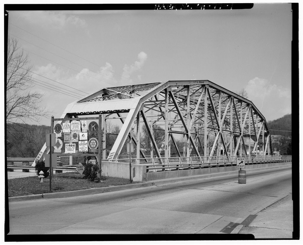
Foley Company, at a cost of The bridge consists of a single span with an overall length of 260 feet and a width of 32 feet, excluding cantilevered sidewalks on either side of the trusses. Minimum clearance under each portal strut is 20' 6", with a maximum clearance height of 29' 10" reached under the central struts. The design exhibits 12 panels, with each measuring 22' 4". Material of construction is riveted steel throughout for chords, laterals, bracing and deck. Portal bracing exhibits iron struts and no spandrels. The deck is composed of 11 steel stringers supported by 13 steel floor beams. These beams are tied together with cross braces. The bridge is anchored to the concrete abutments by fixed bearings on the west side and roller bearings on the east side.
These are pinned to the steel lower chord. Incorporated within the original design was a single set of tracks for an interurban link. No date plate was placed on the bridge. Since its construction in the bridge has experienced minor rehabilitation over the years. This work has included painting at various times, replacement of several diagonals, and the deck has been replaced several times. Because traffic had increased on the road that the bridge served, a new continuous steel plate girder bridge was built in approximately 50 feet to the south. The traffic pattern was then altered to allow for westbound one-way traffic to be carried on the Milford Bridge and eastbound on the new bridge.
This arrangement was satisfactory until an inspection was undertaken in at which time, it was determined that the Milford Bridge should be posted to carry only 90 percent of the legal load limit because of a concern for the ability of the bridge to adequately carry the increasing traffic. In it was determined that the Milford Bridge needed to be closed to all traffic because of substantial deterioration to certain areas of the floor beams, lower chord, deck stringers, lateral bracing and connections. With the closing of the bridge, two-way traffic was implemented on the adjacent bridge. At the time the bridge was closed, the highway was carrying an average of 19, 280 vehicles per day.
Because of the increased traffic, it has been decided that the Milford Bridge is to be demolished and replaced with a new bridge that will carry one-way traffic across the river. Milford Bridge HAER No. OH-77 (Page 4) SOURCES OF INFORMATION Bancroft, Arthur P., Gazetteer and Directory of Clermont County. David 0. Cowen and Company, Batavia, Ohio. Emerson, W. D., Map of Hamilton County. Cincinnati, Ohio, Evers, Louis H., History of Clermont County. J. B. Luppincott and Company, Philadelphia, Hamilton County Commissioner's Minutes, Hamilton County Courthouse, Cincinnati, Ohio. Book 73, Page November 9, Book 74, Page March 16, Book 76, Page 32, November 7, Moessinger, G. and Fred Bertsch, Map of Hamilton Co. Ohio.
Cincinnati, Ohio, Ohio Department of Transportation, Documentation for Consultation: US Route 50 - Milford Bridge. Lebanon, Ohio, March Ohio Department of Transportation, The Ohio Historic Bridge Inventory Evaluation, and Preservation Plan. Ohio Department of Transportation, Milford Bridge Structural File No. Lebanon, Ohio. Santoro Engineering Company, Engineering Inspection and Design/Rehabilitation Study on the Historic USR 50 Bridge Over Little Miami River Bridge No. HAM-50-3645L. Batavia, Ohio, Thirey and Mitchell, Encyclopedic Directory and History of Clermont County. S. Rosenthal and Company, Cincinnati. Williams, Byron, History of Clermont and Brown Counties. Volume One, Reprint by Gateway Press, Inc., Baltimore, MD, MILFORD BRIDGE HAER No.
OH-77 (Page 5', w C3 5 Q 0) n -^H OS > 03 i 1 Q ^H (3 O U fa <D t-l > 1-1 o .o'.sr MILFORD BRIDGE HAER No. OH-77 (Page 7 MILFORD BRIDGE HAER No. OH-77 (Page ) D
Site Map
 Block
Block