 Block
From the record
17 National Register listings published here.
Sources: the National Register database, National Park Service
104 topographic sheets cover 78 settlements here, and 17 properties are on the National Register of Historic Places.
17 National Register listings published here.
Sources: the National Register database, National Park Service
Every property in this county listed on the National Register of Historic Places, with the year it was listed and the federal nomination document.
| Photograph | Property | Type | Listed | Reference |
|---|---|---|---|---|
| Cascade Distillery Site | site | 1994 | 94000578 | |
 | Coffee County Courthouse | building | 1974 | 74001905 |
| Crouch-Ramsey Family Farm | district | 2005 | 05000830 | |
| Farrar Distillery | site | 1984 | 84003472 | |
| Fox House | building | 2023 | 100009078 | |
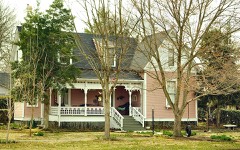 | L. D. Hickerson House | district | 1993 | 89001395 |
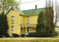 | John H. Leming House | building | 2011 | 11000092 |
| Manchester Cumberland Presbyterian Church | building | 1992 | 92000781 | |
| Normandy Dam Project | district | 2017 | 100001464 | |
| North Atlantic Street Historic District | district | 1988 | 88001052 | |
| North Washington Street Historic District | district | 1993 | 89001396 | |
 | Old Stone Fort | site | 1973 | 73001757 |
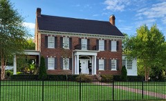 | Smotherman House | building | 2018 | 100002747 |
| T-201 Aircraft Hangar | building | 2021 | 100006711 | |
 | Tullahoma Municipal Building | building | 2018 | 100002748 |
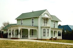 | Wilkinson-Keele House | building | 2006 | 06001040 |
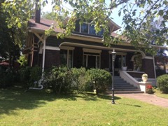 | Wilson-Crouch House | building | 2017 | 100001820 |
Every wildfire the federal occurrence database records inside this county: 648 of them, burning about 2,901 acres. None started naturally and 110 were recorded as arson. Each settlement page carries the fires within five miles of it.
| Reported cause | Fires |
|---|---|
| Debris and open burning | 383 |
| Arson/incendiarism | 110 |
| Equipment and vehicle use | 72 |
| Missing data/not specified/undetermined | 41 |
| Misuse of fire by a minor | 9 |
| Smoking | 8 |
| Other causes | 8 |
| Railroad operations and maintenance | 7 |
| Recreation and ceremony | 4 |
| Power generation/transmission/distribution | 4 |
| Fireworks | 2 |
The five largest, by the area the report gives. Three of them were set deliberately.
| Date | Cause | Size | Reported by | Name on the report |
|---|---|---|---|---|
| 25 April 2009 | Missing data/not specified/undetermined | 191 acres | Tennessee Division of Forestry | RIFLE RANGE FIRE |
| 8 February 2001 | Arson/incendiarism | 143 acres | Tennessee Division of Forestry | not named |
| 12 February 2007 | Arson/incendiarism | 100 acres | Tennessee Division of Forestry | HICKERSON RD 1 |
| 16 November 2001 | Arson/incendiarism | 70 acres | Tennessee Division of Forestry | not named |
| 9 April 2017 | Missing data/not specified/undetermined | 68 acres | Tennessee Division of Forestry | DROP ZONE FIRE |
| 7 September 1999 | Equipment and vehicle use | 65 acres | Tennessee Division of Forestry | not named |
| 16 September 1999 | Railroad operations and maintenance | 65 acres | Tennessee Division of Forestry | not named |
| 2 December 1999 | Debris and open burning | 60 acres | Tennessee Division of Forestry | not named |
Every settlement page carries the fires within five miles of it - see the settlement index below.
The NOAA Storm Events Database holds 406 reports for this county, causing 2 deaths, 32 injuries and about $11,483,531 in recorded property damage. Each settlement page carries the reports that name it.
| Kind of event | Reports |
|---|---|
| Thunderstorm Wind | 238 |
| Hail | 87 |
| Flash Flood | 33 |
| Tornado | 28 |
| Lightning | 8 |
| Flood | 7 |
| Funnel Cloud | 3 |
| Heavy Rain | 2 |
The most serious of them, by death, then injury, then recorded damage. The accounts are quoted exactly as the forecast office filed them.
| When | Event | Place named | Harm | What the report says |
|---|---|---|---|---|
| November 2002 | Tornado (F2) | Fredonia | 2 killed, 24 hurt, $250,000 | An F2 tornado killed 2 people and injured 24 others. The 2 people were inside their mobile home when the tornado struck. The mobile home was in the New Union Heights subdivision, off state Highway 53 north of Manchester. The boy was moved from his mobile home to the Hillcrest Baptist Church. He died in the church at 705 PM CST. A relative of the boy, a 43-year-old male, was also killed. He was impaled on the upright lid of a washing machine. 24 homes were destroyed, 51 other homes were damaged. 9 mobile homes were destroyed and 5 were damaged. 14 outbuildings also were damaged. |
| April 1996 | Thunderstorm Wind | Manchester | 2 hurt, $500,000 | no account filed |
| December 1990 | Thunderstorm Wind | not stated | 2 hurt | no account filed |
| November 2016 | Tornado (EF1) | Tullahoma | 1 hurt, $750,000 | An EF-1 tornado touched down just inside the Coffee County line west of Tullahoma. This tornado tracked through the northside of Tullahoma crossing over State Route 16/Jackson Street damaging several businesses with mostly roof damage observed. The tornado then moved across the Lakewood Golf and Country Club and Lake Tullahoma Estates neighborhoods where several hundred trees were uprooted and snapped. Almost all of the structural damage in these neighborhoods were due to downed trees. One person sustained a minor injury when a tree fell on their car. Once the tornado crossed the lake, it lifted just before Cherry Springs Road. |
| August 2023 | Thunderstorm Wind | Pocahontas | 1 hurt, $10,000 | Severe thunderstorm winds downed a tree onto a vehicle at Woodbury Highway and Gnat Hill Road north of Manchester which injured a person who was in the vehicle at the time. Damages are a rough estimate. |
| January 1999 | Thunderstorm Wind | Manchester | 1 hurt | A metal roof from an H&R Block building was lifted and hurled into vehicles in downtown Manchester. There was one injury. The roof was estimated to be 20 feet by 20 feet, was made of aluminum and 2 by 4s. |
| April 1974 | Tornado (F3) | not stated | 1 hurt | no account filed |
| October 2001 | Tornado (F2) | Manchester | $3,000,000 | Roof and one wall to a factory was blown off at Manchester Industrial Park. There was structural damage to other buildings in the Joint Industrial Park. Also, several trees were down. One estimate for damage from the combination of straight line winds and the tornadoes, which extended from the commercial vehicle weigh station at I-24 to the Manchester Industrial Park, continuing to Old Airport Road and the Ashbury community, were in the several millions of dollars. |
| October 2011 | Hail | Tullahoma | $1,000,000 | Hail ranging from quarter to baseball size damaged numerous cars, homes, businesses, and schools in and around Tullahoma. The majority of the hail was quarter to golfball size, but some hailstones were reportedly up to baseball size. Videos showed the hail fell for around five minutes. |
| August 2007 | Thunderstorm Wind | Manchester | $556,000 | Spotter reported roof debris along I-24 at exit #114. Report was verified by sheriff dispatcher. Newspaper articles said major roof damage was done to several hotels with about $550,000 worth of damage. The article stated that damage occurred to the roofs of the Days Inn, Ramada Inn, the Super 8 Motel, and Huddle House. 85 percent of the roof was gone from these businesses. Several vehicles were damaged in nearby parking lots. The Days Inn and Ramada Inn hotels were right off the I-24 exit. ||More than 50 people were displaced at the hotels. The displaced people were moved to nearby hotels. ||Also, a large tree was blown down in Manchester in front of the courthouse. Trees and power lines were also down in other parts of Manchester as well. 2000 people were without power because of the storm.||The article also mentioned that the Quik-Mart located at 2400 Hillsboro Blvd. sustained $2000 worth of damage from aluminum siding that was ripped off the building. |
| August 2005 | Thunderstorm Wind | Manchester | $500,000 | Strong thunderstorm winds tore away half of the gymnasium roof at the Coffee County Middle School in Manchester. Rains from the thunderstorms left pools of water on the gym floor. The old foam roof was found to be less than the 2 inches thick the contract had called for, and is no longer under warranty. |
| April 1996 | Lightning | Tullahoma | $500,000 | no account filed |
| February 2019 | Flash Flood | Red Hill | $329,890 | Media reports and local law enforcement reported 34 roads were flooded and closed across Coffee County, including Skinner Flat Road, Estern lane, and Scott Swinney Drive in Manchester. A water rescue was conducted in the 1500 block of Hillsboro Viola Road, and another water rescue of a family was conducted in Hillsboro. |
| November 2016 | Tornado (EF1) | Red Hill | $250,000 | A new circulation formed east-southeast of the Tullahoma tornado and touched down just southeast of Manchester. Although not on the ground for long, several dozen trees were snapped and uprooted and several barns and outbuildings were heavily damaged along the path. A one story log cabin style house was picked up off of the foundation and moved 6-8 feet off of center with most of the house still fully intact. Unfortunately, this house was not properly attached to the foundation hence the EF-1 rating. |
| January 1998 | Tornado (F1) | Manchester | $250,000 | The Coffee county EMA director surveyed the damage. 5 homes had some roof damage, but a brick home lost an entire roof. Some outbuildings were destroyed. There were no injuries. A woman did see a funnel before the tornado struck. Trees and power lines were down on Ragsdale Road. |
| March 1975 | Tornado (F1) | not stated | $250,000 | no account filed |
| March 1959 | Tornado (F3) | not stated | $250,000 | no account filed |
| January 1957 | Tornado (F2) | not stated | $250,000 | no account filed |
| May 2020 | Thunderstorm Wind | Tullahoma | $202,740 | Numerous trees and power lines were blown down across Tullahoma and much of the rest of Coffee County with widespread power outages. |
| February 2014 | Tornado (EF1) | Betsy Willis | $200,000 | An NWS storm survey confirmed an EF1 tornado touched down along Interstate 24 northwest of Pelham where a tree was snapped and two billboards damaged. Several more trees were uprooted along Betsy Willis Road. A farm suffered significant damage just north of Betsy Willis Road on the west side of Highway 41, with 3 grain silos blown off their base and destroyed and a barn losing part of its roof. An outbuilding at the farm was also destroyed with debris blown southeast across Highway 41. Another barn on the east side of Highway 41 suffered minor roof damage. More trees were blown down east of Highway 41 with another outbuilding destroyed and debris blown across adjacent fields. The tornado then moved into inaccessible forests before lifting. Max winds were estimated up to 90 mph. |
| August 2023 | Thunderstorm Wind | Manchester | $100,000 | Sentinel satellite imagery along with damage photos indicate an intense microburst struck the Manchester area, causing a 1/2 mile wide swath of damage along a roughly 7 mile path across southern and southeastern Manchester. Scattered trees were blown down in this area with several trees falling onto homes and businesses. Some roads reported impacted included Highway 55, Highway 41, Perry Road, Old Pocahontas Road, Royal Trail, Doak Road, Ragsdale Road, and Vaughn Hollow. Winds were estimated up to 75 mph. Damages are a rough estimate. |
| November 2010 | Flash Flood | Tullahoma Arpt | $100,000 | Because of heavy rains and strong winds, some trees across the county were uprooted and blown over power lines and roadways. Lake Hills Road located off of Ovoca Road in Tullahoma was partially blocked in one area due to trees and water across the roadway. Coffee County Communinications Center officials had to send officers to the Pocahontas area in north Coffee county near State Highway 130 and several other areas across the county due to high waters. Tulllahoma police also reported water across Decherd Street, with multiple reports of debri washing across this road and other roads across the county also. |
| October 2009 | Heavy Rain | Forest Mill | $100,000 | Two people were in critical conditions following a three-vehicle wreck at the intersection of Woodbury Highway and Riddle Road in Manchester. A total of 10 persons were transported by ambulance from the wreck site to local hospitals. People involved in the accident ranged from age four to age 68. An ambulance official reported that extremely heavy rainfall conditions were likely a factor in the wreck. Final conditions of the 10 individuals, including two that were in critical condition, was unknown. This three vehicle accident included a 2004 Toyota Sierra Van that carried six people, 2007 Toyota Highlander that carried three people, and a 2003 Red Durango that carried a single person. Exact total damage amounts to the vehicles was unknown. |
| November 2018 | Tornado (EF0) | Rutledge Hill | $75,000 | Although a NWS storm survey originally determined the damage path across Franklin, Coffee, and Grundy Counties to be one long-track tornado, high-resolution satellite imagery from NASA Sport and Google Earth in May 2019 clearly showed that the original track was actually two separate tornadoes. This major EF-2 tornado, which began in Franklin County near Tims Ford Lake, weakened considerably to EF-0 as it entered the extreme southeastern portion of Coffee County, with just a few trees blown down along Rutledge Hill Road. The worst damage was along Coker Road where a barn was destroyed, another barn suffered roof damage, and the front porch of a home was ripped off causing minor roof damage. After taking a sharp bend to the east, the tornado caused severe damage to an outbuilding on Boyd Road. Several outbuildings were destroyed and a house sustained roof damage when its front porch was ripped off. Numerous more trees were blown down further to the east on Rutledge Hill Road and along and onto I-24, which caused a multi-vehicle accident at mile marker 126. Another barn suffered roof damage on Sims Lane before the tornado moved into Grundy County. The tornado then intensified rapidly to EF-2 in extreme southwest Grundy County, with a nearly-finished brand new home almost completely destroyed on Conry Circle. Two nearby homes suffered significant roof and siding damage, and a barn lost nearly all of its roof. Debris from all of these buildings was blown up to 500 yards to the east and northeast. Further to the east, a mobile home on Frank Wilson Road was knocked off its piers into a garage. The tornado the tracked up and down a nearly 1600 foot tall ridge before reaching Homer White Road, heavily damaging two barns and destroying an outbuilding. Curving more to the northeast, the tornado ripped off the roof of a brick home on Highway 50. Luckily, the house occupants were taking shelter and were not injured. Two adjacent outbuildings were severely damaged, and other nearby homes and barns suffered minor damage. Debris from these buildings was blown up to 500 yards to the northeast. The tornado continued to cause a wide swath of wind damage to trees and buildings along Highway 50 before crossing Schoolhouse Hollow and Nunley Hollow and climbing nearly 1000 feet in elevation onto the Cumberland Plateau. Google Earth and NASA Sport satellite imagery showed hundreds of trees continued to be blown down off to the east as the tornado crossed Highway 108, Eagle Lake Road, and passed along the west side of Eagle Lake before finally lifting just north of Eagle Lake. Total path length of this tornado across Franklin County, southeast Coffee County, into central Grundy County was 29.50 miles. Winds were estimated up to 115 mph. |
| May 2025 | Tornado (EF0) | Noah | $50,000 | This continues the EF-0 tornado that began in far eastern Bedford County. After crossing into Coffee County, the tornado continued along Sixteenth Model Road and dissipated shortly thereafter in a wooded area near Cunningham Lane. Damages are a rough estimate. |
| July 2023 | Flash Flood | Tullahoma | $50,000 | Heavy rain in the Tullahoma area caused flash flooding in numerous areas, including along Wilson Avenue, Ovoca Road, and along North Jackson Street where the O'Reilly's parking lot was flooded. Damages are a rough estimate. |
| October 2022 | Thunderstorm Wind | Manchester | $50,000 | An intense microburst about one half mile long by 250 yards wide struck an area along Interstate Drive from around Monogard Drive southeastward to Highway 55. Sheet metal was blown off a building into a street sign on Monogard Drive. Large sections of the sheet metal roof were also blown off the Coffee Farmers Co-Op building on the west side of Interstate Drive, and a BP gas station canopy lost metal panels. On the east side of the roadway, one home lost a large section of its roof and a front porch column, and several trees were snapped and uprooted in the yard. Another gas station also suffered roof damage, and a nearby warehouse building lost part of its roof and had a cinder block wall collapse. Damage was blown from northwest to southeast, and winds were estimated up to 85 mph. Damages are a rough estimate. |
| July 2015 | Thunderstorm Wind | Hillsboro | $50,000 | Reports from Facebook, Twitter, and broadcast media indicate a large downburst struck the Hillsboro area along the I-24 corridor from Aedc Road southeastward to Stephenson Road. Dozens of trees were snapped or uprooted, blocking and closing numerous roadways including Love Lane Road, Winchester Highway, Limbo Drive, Oakley Street, Prairie Plains Road, and Stephenson Road. Many of the trees fell on homes and vehicles in the area around Limbo Road near the center of the downburst. Based on damage photos, winds were estimated to range between 60 and 80 mph. |
| January 2013 | Tornado (EF0) | Manchester | $50,000 | Based on a survey completed by Coffee County Emergency Management, an EF0 tornado was confirmed in and near Manchester. The sheet metal roof of a home was partially blown off on Walker Road in Manchester and a tree was blown down in the yard. A few trees were blown down and the press box was destroyed at the Coffee County Middle School. Intermittent damage consisting of dozens of snapped trees and damaged roofs continued for approximately 5 miles to the northeast. The last evidence of damage was on Shining Star Lane just off Ragsdale Road where a home had minor damage and a few trees were blown down. |
| July 2012 | Thunderstorm Wind | Tullahoma | $50,000 | Numerous trees were blown down on the west side of Tullahoma in the Bel Aire Neighborhood including near the interstection of Lincoln Street and Crestwood Drive. One tree destroyed a shed and damaged a house. Another home on George Lane had its garage doors blown in. |
| August 2010 | Thunderstorm Wind | Tullahoma | $50,000 | Trees were blown down in the Viola, Hillsboro, and Tullahoma areas. Dozens of trees were blown down in the Bel-Aire neighborhood in Tullahoma. |
| October 2010 | Thunderstorm Wind | Tullahoma | $50,000 | A spotter reported large trees uprooted near the downtown square and also large trees branches downed also across the city of Tullahoma. |
| September 2009 | Flash Flood | Beech Grove | $50,000 | Isolated to scattered flooding occurred across the county. There were a couple of accidents on Interstate 24 during the heavy rain. Water was overflowing ditches in the 1700 block of West Lincoln Street and onto the roadway. Highway department workers also placed barriers in areas of the county. Police received a report of a tree being across the roadway in the Carter Blake Road area. Several minor accidents were reported also across the county. No information was provided on number and extent of any injuries associated with these accidents. |
| April 2008 | Tornado (EF0) | Beech Grove | $50,000 | An EF0 tornado struck northwest Coffee County. A tractor trailer truck was blown on its side as it was heading westbound on Interstate 24 and at mile marker 99. |
| October 2004 | Thunderstorm Wind | Tullahoma | $50,000 | 200 trees fell in the western part of Tullahoma. The storm appeared to have started near Wilson Avenue and Braggs, downing 5 trees. The storm continued to march east. 50 homes received some damage either from fallen trees or flooding. 11 homes received major damage from fallen trees. 3 homes received damage from flooding.The city cemetery receieved damage to headstones due to trees falling on them. Areas affected by fallen trees were Cowan Lane, Braggs Circle, Cumberland Avenue, Crestwood Drive, Sharondale, and Bel-Aire. High winds blew an aluminum storage shed from 207 Ashley Court to the front of 201 Ashley Court, which is about 100 yards. |
| October 2004 | Flash Flood | Tullahoma | $50,000 | Vehicles were trapped in flooding water on Highway 55 in Tullahoma. By 0320 AM CST, numerous streets were flooded along with 2 vehicles. By 0525 AM CST, widespread flooding was occurring in Tullahoma by law enforcement. Storm drains had backed up. One vehicle stalled in high water at Waggoner Park. The Tullahoma Water Plant received 5.34 inches. One estimate in an EMA report placed the rainfall at about 8 inches in a few hours. An EMA report said 3 homes were damaged due to flooding. |
| November 2002 | Tornado (F2) | Fredonia | $50,000 | The F2 tornado blew down a tree and a light pole at 3737 Woodbury Highway at mile marker 9 on Woodbury Highway. Also, two fully loaded tracker trailer trucks were blown around on I-24 near Busy Corner or mile marker 105. One truck was in the east bound lane and the other tracker trailer truck in the west bound lane of I-24. |
| April 1998 | Tornado (F1) | Manchester | $50,000 | 911 center reported numerous roofs off of buildings in downtown Manchester and also widespread wind damage. |
| May 1994 | Thunderstorm Wind | Summittville | $50,000 | A mobile home was destroyed and a family pet was killed. |
| June 1994 | Tornado (F0) | Hillsboro | $50,000 | A tornado touched down near Hillsboro. The roof to a house and a barn were damaged. Several trees were blown down. A corn field was damaged. |
| October 2007 | Thunderstorm Wind | Fredonia | $35,000 | Part of a roof was blown off a house northwest of Manchester, specifically at 4457 Murfreesboro Highway. A 500-pound swing was tossed 30 feet from the back porch and landed against a tree. Several trees were blown down in the area as well. Damage to the home was estimated between $30,000 and $40,000. |
| April 2011 | Thunderstorm Wind | Tullahoma | $30,000 | Several large trees were downed near and around the city of Tullahoma and in the downtown area. The arms on a railroad crossing sign were also broken. |
| June 2008 | Thunderstorm Wind | Tullahoma | $30,000 | Trees and power lines were down in Tullahoma. A 100-year-old oak tree was blown down on Polk St. Another tree was blown down on Lincoln St. In addition, a tree fell on a house on Lindenwood Street in Tullahoma, and also just 4 houses away, a tree fell on a 2007 Dodge Grand Caravan.||1,300 people were without power in Tullahoma at one time during the thunderstorm. |
| July 2004 | Thunderstorm Wind | Tullahoma | $30,000 | 6 trees blew down on homes. |
| July 2023 | Thunderstorm Wind | Hickerson | $25,000 | Severe thunderstorm winds downed trees and snapped powerlines with multiple power outages reported along Short Springs Road northeast of Tullahoma. Damages are estimated. |
| October 2022 | Thunderstorm Wind | Manchester | $25,000 | Very strong thunderstorm winds in Manchester downed numerous trees in the city, including at Dave King Park, a trailer court on Oakdale Street, Woodland Street, South Spring Street, and other areas. Damages are a rough estimate. |
| May 2012 | Thunderstorm Wind | Tullahoma | $25,000 | Multiple trees were downed resulting in power outages in Tullahoma. |
| August 2012 | Thunderstorm Wind | Gnat Hill | $25,000 | The Manchester Times reported a home at 1374 Lakeshore Drive in the Lakewood Park had half of the roof blown off. Numerous trees all along Lakeshore Drive were snapped or uprooted. |
| March 2011 | Thunderstorm Wind | Manchester | $25,000 | Downed power lines and trees occurred across the city of Manchester. |
| August 2010 | Thunderstorm Wind | Tullahoma | $25,000 | Spotter reported numerous trees downed on Polk Street in Tullahoma. |
| June 2009 | Lightning | Fredonia | $25,000 | Lightning struck the roof and started an attic fire in the the Richland Hills Subdivision near Manchester. Exact extent of damage to attic was unkown. |
| February 1999 | Lightning | Manchester | $25,000 | Lightning hit the Coffee County Consolidated Communications Center and knocked out emergency 911 calls for about an hour. The Center also handles dispatch calls for area law enforcement, fire and ambulance services. Emergency calls had to be routed through the jail. This was the second time in 12 years that the Communications Center was hit this bad by lightning. |
| May 1984 | Tornado (F1) | not stated | $25,000 | no account filed |
| August 2023 | Thunderstorm Wind | Hoodoo | $20,000 | Severe thunderstorm winds reported numerous trees down in the Beechgrove area, including along Hoodoo Norton Branch Road. Power outages were also reported in the area. Damages are a rough estimate. |
| December 2021 | Tornado (EF1) | Flowertown | $20,000 | This tornado touched down in the Raus community near Smith Chapel Road at Elijah Parker Road in far southern Bedford County, where it caused EF0 damage including blowing down a wall at the Raus Community Center and knocking down trees on Powell Hollow Road. Moving eastward, the tornado crossed into Moore County and strengthened to EF-1 where it blew down numerous trees and caused minor damage to several homes along Brinkley Road, Ledford Mill Road, and Motlow College Road. The tornado then moved into Coffee County, continuing to blow down trees and damage homes in areas along and near Ledford Mill Road. The tornado weakened as it entered and moved across northern portions of the city of Tullahoma, where it damaged signs and outbuildings along North Jackson Street, then blew down numerous trees and caused minor roof damage to homes on Normandy Road, Riley Creek Road, around the Lakewood Golf Course, and in the Lake Tullahoma Estates before lifting. |
| July 2013 | Thunderstorm Wind | Manchester | $20,000 | The Coffee County 911 Center reported 18 trees down across Coffee County. Roads blocked by trees included Cascade Hollow Road, Noah Road, Ferry Hill Road, and Woodbury Highway. |
| June 1995 | Thunderstorm Wind | Manchester | $20,000 | A mobile home lost its roof. Numerous trees and power lines were knocked down. |
| April 2026 | Thunderstorm Wind | Manchester | $15,000 | Severe thunderstorm winds downed trees across Coffee County and caused roof damage to the library in Manchester. Damages are a rough estimate. |
| February 2025 | Thunderstorm Wind | Manchester | $15,000 | Severe thunderstorm winds downed a tree onto a home on East Harp Street in Manchester. Damages are a rough estimate. |
| May 2024 | Thunderstorm Wind | Shady Grove | $15,000 | According to the Coffee County Highway Department, severe thunderstorm winds downed several trees across eastern portions of the county, including Casey Road and Bell Road. Damages are a rough estimate. |
The Survey's mineral resources record lists 21 workings inside this county. 6 still produce and 15 are closed or unrecorded. Each settlement page carries the workings within five miles of it.
| Commodity | Workings |
|---|---|
| Uranium, Oil Shale | 6 |
| Uranium | 6 |
| Oil Shale | 6 |
| Stone, Crushed/Broken | 3 |
| Sand and Gravel, Construction | 3 |
| Stone, Crushed/Broken, Limestone, General | 1 |
| Limestone, General, Stone, Crushed/Broken | 1 |
| Silica | 1 |
The least common of them first, because a county's hundredth gravel pit says nothing its first ten did not.
| Where | Site | Commodity | Status | Recorded |
|---|---|---|---|---|
| Chert Pit | Silica | Past Producer | ||
| Hillsboro Quarry | Limestone, General, Stone, Crushed/Broken | Producer | Limestone | |
| Winton Quarry Pit #374 | Stone, Crushed/Broken, Limestone, General | Producer | Limestone | |
| Cumberland Mountain Sand Co. Pit | Stone, Crushed/Broken | Past Producer | Sedimentary | |
| Cumberland Mountain Sand Co. Pit | Sand and Gravel, Construction | Producer | 1956 | |
| Gravel Pit | Sand and Gravel, Construction | Past Producer | ||
| Hillsboro Mine | Sand and Gravel, Construction | Producer | ||
| Hillsboro Quarry | Stone, Crushed/Broken | Producer | ||
| Winton Quarry Pit #374 | Stone, Crushed/Broken | Producer | ||
| Outcrop Sample For Uranium | Uranium, Oil Shale | Occurrence | ||
| Outcrop Sample For Uranium | Uranium, Oil Shale | Occurrence | ||
| Outcrop Sample For Uranium | Uranium, Oil Shale | Occurrence | ||
| Outcrop Sample For Uranium | Uranium, Oil Shale | Occurrence | ||
| Outcrop Sample For Uranium | Uranium, Oil Shale | Occurrence | ||
| Outcrop Sample For Uranium | Uranium, Oil Shale | Occurrence | ||
| Outcrop Sample For Uranium | Uranium, Oil Shale | Occurrence | ||
| Outcrop Sample For Uranium | Uranium, Oil Shale | Occurrence | ||
| Outcrop Sample For Uranium | Uranium, Oil Shale | Occurrence | ||
| Outcrop Sample For Uranium | Uranium, Oil Shale | Occurrence | ||
| Outcrop Sample For Uranium | Uranium, Oil Shale | Occurrence | ||
| Outcrop Samples For Uranium | Uranium, Oil Shale | Occurrence |
Named settlements recorded in the Geographic Names Information System, each with the topographic sheets covering it. Villages, hamlets and abandoned places alike. Each is shown with the nearest named watercourse or landform and the survey quadrangle it falls on.
District 9 · 37388 · On West Fork Rock Creek · Tullahoma quadrangle
17 sheets, 1936 to 1981
District 2 · 37355 · On Hickerson Spring Branch · Manchester quadrangle
17 sheets, 1936 to 1981
District 5 · 37388 · On Hickerson Spring Branch · Normandy Lake quadrangle
18 sheets, 1936 to 1981
No longer a settlement
District 8 · 37388 · On West Fork Rock Creek · Normandy Lake quadrangle
18 sheets, 1936 to 1981
District 6 · 37355 · On Gum Swamp Branch · Fredonia quadrangle
17 sheets, 1913 to 1985
No longer a settlement
District 3 · 37355 · Near Greenbrier Flat · Fredonia quadrangle
17 sheets, 1913 to 1985
District 6 · 37357 · Near Burks Hill · Morrison quadrangle
19 sheets, 1893 to 1981
No longer a settlement
District 3 · 37018 · Near Robinson Ridge · Beechgrove quadrangle
15 sheets, 1913 to 1985
District 4 · 37355 · On Perry Creek · Fredonia quadrangle
17 sheets, 1913 to 1985
No longer a settlement
District 8 · 37388 · On West Fork Rock Creek · Normandy Lake quadrangle
18 sheets, 1936 to 1981
District 1 · 37355 · On Goodman Spring Branch · Manchester quadrangle
17 sheets, 1936 to 1981
District 1 · 37355 · On Goodman Spring Branch · Manchester quadrangle
17 sheets, 1936 to 1981
District 4 · 37357 · On Pocahontas Branch · Hollow Springs quadrangle
15 sheets, 1913 to 1985
No longer a settlement
District 5 · 37388 · Normandy Lake quadrangle
18 sheets, 1936 to 1981
No longer a settlement
District 9 · 37388 · On West Fork Rock Creek · Tullahoma quadrangle
17 sheets, 1936 to 1981
District 4 · 37357 · On Pocahontas Branch · Hollow Springs quadrangle
15 sheets, 1913 to 1985
District 5 · 37355 · On Fuller Branch · Normandy Lake quadrangle
18 sheets, 1936 to 1981
No longer a settlement
District 3 · 37018 · On Robinson Ridge · Beechgrove quadrangle
15 sheets, 1913 to 1985
No longer a settlement
District 2 · 37355 · On Huckleberry Creek · Manchester quadrangle
17 sheets, 1936 to 1981
District 5 · 37388 · On Wiley Creek · Normandy Lake quadrangle
18 sheets, 1936 to 1981
District 2 · 37355 · On Hickory Flat Creek · Manchester quadrangle
17 sheets, 1936 to 1981
District 9 · 37388 · On West Fork Rock Creek · Tullahoma quadrangle
17 sheets, 1936 to 1981
District 4 · 37355 · On Summitville Mountain · Morrison quadrangle
19 sheets, 1893 to 1981
District 3 · 37355 · On Muddy Branch · Fredonia quadrangle
17 sheets, 1913 to 1985
No longer a settlement
District 7 · 37388 · On West Fork Rock Creek · Tullahoma quadrangle
17 sheets, 1936 to 1981
District 3 · 37183 · On Panhandle Branch · Noah quadrangle
16 sheets, 1913 to 1985
No longer a settlement
District 7 · 37388 · On West Fork Rock Creek · Tullahoma quadrangle
17 sheets, 1936 to 1981
District 1 · 37355 · Near Grindstone Hollow · Manchester quadrangle
17 sheets, 1936 to 1981
District 1 · 37355 · Near Grindstone Hollow · Manchester quadrangle
17 sheets, 1936 to 1981
District 2 · 37355 · On Hickory Flat Creek · Manchester quadrangle
17 sheets, 1936 to 1981
The vanished settlements of Coffee County: the places named above that are no longer on the map.