 Block
From the record
17 National Register listings published here.
Sources: the National Register database, National Park Service
71 topographic sheets cover 75 settlements here, and 17 properties are on the National Register of Historic Places.
17 National Register listings published here.
Sources: the National Register database, National Park Service
Every property in this county listed on the National Register of Historic Places, with the year it was listed and the federal nomination document.
| Photograph | Property | Type | Listed | Reference |
|---|---|---|---|---|
| Charlotte Courthouse Square Historic District | district | 1977 | 77001266 | |
 | Dickson County War Memorial Building | building | 1999 | 99000365 |
 | Dickson Post Office | building | 1996 | 96000934 |
| Drouillard House | building | 1977 | 77001267 | |
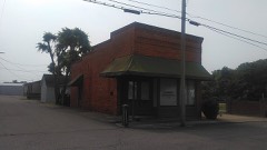 | Farmers and Merchants Bank Building | building | 1993 | 93001161 |
 | First National Bank of Dickson | building | 1986 | 86000398 |
 | Halbrook Hotel | building | 1990 | 90000915 |
| Leech-Larkins Farm | district | 1995 | 95001015 | |
| Lonesome | building | 2021 | 100006381 | |
| Miller Family Farm | district | 2005 | 05000360 | |
| Montgomery Bell CCC Camp SP-5/NP-15 | site | 2022 | 100007906 | |
| Richard C. Napier House | building | 1988 | 88001110 | |
| Neblett Place Farm | district | 1995 | 95000267 | |
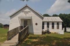 | Promise Land School | building | 2007 | 07000159 |
 | Ruskin Colony Grounds | building | 1974 | 74001911 |
| Peter Paul Shule Barn | building | 1982 | 82003967 | |
 | St. James Episcopal Church | building | 1977 | 77001268 |
Every wildfire the federal occurrence database records inside this county: 305 of them, burning about 1,224 acres. 5 started naturally and 29 were recorded as arson. Each settlement page carries the fires within five miles of it.
| Reported cause | Fires |
|---|---|
| Debris and open burning | 168 |
| Missing data/not specified/undetermined | 30 |
| Equipment and vehicle use | 30 |
| Arson/incendiarism | 29 |
| Smoking | 13 |
| Other causes | 7 |
| Misuse of fire by a minor | 6 |
| Railroad operations and maintenance | 6 |
| Power generation/transmission/distribution | 5 |
| Natural | 5 |
| Fireworks | 3 |
| Recreation and ceremony | 3 |
The five largest, by the area the report gives. One of them was set deliberately.
| Date | Cause | Size | Reported by | Name on the report |
|---|---|---|---|---|
| 21 March 1999 | Debris and open burning | 70 acres | Tennessee Division of Forestry | not named |
| 20 January 1997 | Debris and open burning | 50 acres | Tennessee Division of Forestry | not named |
| 4 November 2005 | Debris and open burning | 50 acres | Tennessee Division of Forestry | not named |
| 28 March 2000 | Equipment and vehicle use | 42 acres | Tennessee Division of Forestry | not named |
| 8 January 2006 | Missing data/not specified/undetermined | 40 acres | Tennessee Division of Forestry | not named |
| 21 April 2007 | Arson/incendiarism | 30 acres | Tennessee Division of Forestry | HASSELL FIRE |
| 7 November 1999 | Recreation and ceremony | 29 acres | Tennessee Division of Forestry | not named |
| 12 March 2008 | Debris and open burning | 25 acres | Tennessee Division of Forestry | not named |
Every settlement page carries the fires within five miles of it - see the settlement index below.
The NOAA Storm Events Database holds 487 reports for this county, causing 1 death, 12 injuries and about $20,206,310 in recorded property damage. Each settlement page carries the reports that name it.
| Kind of event | Reports |
|---|---|
| Thunderstorm Wind | 275 |
| Hail | 107 |
| Flash Flood | 58 |
| Tornado | 23 |
| Heavy Rain | 9 |
| Flood | 8 |
| Lightning | 4 |
| Funnel Cloud | 3 |
The most serious of them, by death, then injury, then recorded damage. The accounts are quoted exactly as the forecast office filed them.
| When | Event | Place named | Harm | What the report says |
|---|---|---|---|---|
| March 2002 | Flash Flood | North Portion | 1 killed | Sheriff reported Jones Creek Road was under water. Also, EMA reported that a 46 year old man was swept away near White Bluff around 8 PM CST on Trace Creek Rd. Rock Church Road near Dickson was under water. Dickson County Schools were closed Monday March 18 because of road closures. |
| April 1998 | Tornado (F3) | Tidwell | 5 hurt, $500,000 | The tornado destroyed or damaged 35 homes, destroyed 7 mobile homes, uprooted trees and demolished cars along a 2 mile path on Nails Creek Road. The Dickson Convention Center/Flea Port USA, on TN Route 46 South, lost a wall and part of a roof. |
| December 2023 | Tornado (EF2) | Woods Vly | 2 hurt, $2,000,000 | This EF-2 tornado touched down southwest of the intersection of Woods Valley Road and Bone Road, then moved east-northeast where it snapped a few pine trees and caused roof damage to a home. Continuing east-northeast, the tornado damaged a mobile home and outbuilding on Gamble Hollow Road. The tornado intensified to EF-2 as it crossed Highway 48, causing the most significant damage along its path as it completely removed the top level of a home, leaving only the lower exterior walls in place. Winds were estimated at 125 mph in this area. The tornado maintained its strength as it continued toward Freeman Loop, striking an A-frame house and ripping off the top half of the home. As it continued eastward, the tornado did substantial damage to another mobile home and snapped and uprooted dozens of trees along Freeman Loop before finally lifting after crossing Barton's Creek. |
| December 2021 | Tornado (EF2) | Oak Grove | 2 hurt, $2,000,000 | This strong EF-2 tornado began in extreme northern Hickman County south of I-40, then tracked northeast across Plunders Creek Road and Brambling Springs Road where it blew down numerous trees. The tornado crossed I-40 near mile marker 166 along Piney Road where it snapped and uprooted dozens of trees on N Mount Sinai Road. The most intense damage occurred on Murrell Drive where multiple homes were heavily damaged or destroyed as they shifted off of their foundations, experienced extensive roof damage, or had exterior walls collapse. In addition to the structural damage, hundreds of trees were snapped or uprooted in the same area. The tornado continued northeast damaging trees on Lena Road, and causing roof damage to homes on Stephen Street and Ridgecrest Drive. The storm crossed Highway 46, damaging the roof and exterior of the Renaissance Center and snapping electric poles along Printwood Drive. It weakened from that point, damaging multiple trees before dissipating just south of downtown Burns. The track of this tornado was extended using high resolution NASA satellite imagery, with a total path length of 10.87 miles. |
| December 2023 | Tornado (EF2) | Claylick | 2 hurt, $1,500,000 | This tornado touched down in the Claylick community in eastern Dickson County, snapping and uprooting several trees and destroyed an outbuilding. It quickly intensified to low-end EF-2 strength as it crossed Nosegay Road and demolished a single-story manufactured home. The tornado continued to Pack Annex Road where it did minor damage to the tops of high-tension powerlines and continued to snap large trees as it moved northeast into Cheatham County. The tornado weakened and caused sporadic tree damage as it moved into Cheatham Wildlife Management Area. It strengthened once more, causing prolific tree damage and structure damage to homes along Dry Creek Road south of Ashland City. Just before leaving Cheatham County, the tornado caused minor outbuilding damage and snapped a few trees near River Road. At this point, the tornado Crossed into Davidson County and crossed the Cumberland River. On Pecan Valley Road, some structural damage was observed, but damage was consistent with a weakening tornado with maximum winds of 90 mph. The tornado lifted after crossing Old Hickory Boulevard, just north of Ashland City Highway. |
| June 2022 | Thunderstorm Wind | Oak Grove | 1 hurt, $5,000 | A tree fell onto the porch of a house in the 600 block of Lucas Road, pinning a women underneath and causing her serious injuries. She was hospitalized for several days. |
| April 2006 | Tornado (F3) | Charlotte | $5,000,000 | The tornado touched down on Maple ValleyRoad in northern Dickson County as an F2. 3 mobile homes were leveled and demolished at this location. Numerous trees were uprooted and snapped. The tornado continued along Highway 49 and reached Bellsburg, TN as an F3. A one story brick home was demolished. No walls or roof were left standing, leaving only a basement and a garage. A truck was thrown into the basement by the tornado. The drywall, furniture, and appliances were hurled into the woods at least 100 yards. An aerial survey determined spotty rural damage to trees as this tornado continued into Cheatham County where it hit Greenbrier and then Ashland City. Dickson County had a total of 25 homes destroyed, 8 homes with major damage, and 24 homes and businesses with moderate damage. |
| May 2010 | Flood | Slayden | $1,400,000 | Numerous homes, numerous businesses, numerous non comercial buildings, along with several county, state, and federal roads across the county received damage due to the flood. |
| February 2019 | Flash Flood | Oak Grove | $1,330,000 | Dickson County Emergency Management reported major flash flooding affected central and southern portions of Dickson County. Several roads and bridges were washed out including bridges on Coon Creek Road and on Willow Branch Road at Liberty Road near Charlotte. Numerous other roads were flooded and closed including Shady Hollow Road between College Street and Luther Road in Dickson. Vehicles were stranded in flooding in some areas with water rescues conducted, including on Eno Road and on Harris Road near Tennessee City. Total damage from the flash flooding was estimated at $1,329,000. |
| February 2005 | Thunderstorm Wind | Dickson | $1,000,000 | Damage was first noted about 3/4 of a mile west of the high school. A pool house was moved about 4 inches at Buckner Park. A few trees were blown down as well. Also...a barn was completely destroyed near the high school. Roof damage was observed at the high school, and several windows were broken. Bleachers in a nearby ball field were ripped from their concrete base. Dickson County High School was closed for several days due to clean up efforts. The school reopened on Friday, later in the week. The storm struck on Monday, Feb. 21, on President's Day. Fortunately, classes were not in session, and there were no injuries. |
| May 2020 | Thunderstorm Wind | Dickson | $667,500 | Numerous trees and power lines were blown down with widespread power outages throughout Dickson County including on Hummingbird Lane, Walnut Grove Road, and Yellow Creek Road. A tree was also blown down onto a house on Walnut Grove Road. |
| August 2021 | Flash Flood | Tennessee City | $401,610 | Numerous roads were damaged and closed throughout Dickson County, with dozens of water rescues being conducted. TEMA reported damage to roads throughout the county totaled $401,606. |
| April 2026 | Thunderstorm Wind | Tennessee City | $250,000 | Severe thunderstorm winds downed numerous trees southwest of Dickson, caused structural damage to three barns, and damaged a car. About 3,000 customers were without power in Dickson County. Damages are a rough estimate. |
| April 2025 | Tornado (EF0) | Dickson | $250,000 | A brief EF-0 tornado touched down in Dickson. The tornado caused siding and roof damage to several structures on Cowan Road, Remington Drive, and Archway Drive. Damages are a rough estimate. |
| March 2013 | Tornado (EF1) | Edgewood | $250,000 | A high-end EF1 tornado with maximum winds around 105 mph and a path width of 150 yards that touched down in northeastern Humphreys County and crossed far southeastern Houston County continued moving northeastward before ending just southwest of Vanleer in western Dickson County at 0651 CST. One barn was destroyed and several others suffered roof damage on State Highway 46 north of Cedar Creek Road. Further to the east, one home completely lost its roof on Hill Road causing the collapse of the north exterior wall. However, the roof appeared to be poorly attached to the home. Debris from the home was blown over 100 yards to the|northeast. A poorly constructed single wide mobile home on Haliburton Road was blown 50 yards to the north into trees and completely destroyed. One barn was destroyed and others damaged further east on Haliburton Road. Dozens of trees were snapped or uprooted all along the track. Total path length of this tornado was 10.6 miles. |
| March 1984 | Tornado (F1) | not stated | $250,000 | no account filed |
| April 1974 | Tornado (F1) | not stated | $250,000 | no account filed |
| May 1999 | Thunderstorm Wind | Dickson | $230,000 | EMA reported trees down and trailer home split in half by fallen tree. TEMA reported main cost was for the restoration of utility service. |
| February 2019 | Flash Flood | Thompsons Xrds | $208,000 | Widespread flooding continued across northern Dickson County in the Cumberland Furnace and Charlotte areas, with Highway 48N at St. Paul Road flooded and closed. Water rescues were also ongoing in the Dry Hollow area. |
| July 1999 | Lightning | Dickson | $200,000 | The home of a prominent Dickson physician burned to the ground after lightning struck the house. The family was out of town when the lightning hit the house. The house was located at 198 Farrar Lane in Druid Hills. |
| April 2011 | Thunderstorm Wind | Bakersworks | $125,000 | Several homes suffered minor roof damage, dozens of trees were snapped and uprooted, and a couple of outbuildings were toppled. Maximum wind speeds were estimated to be near 90 mph. Damage extended from near Montgomery Bell Park to White Bluff. |
| April 2011 | Tornado (EF1) | Tennessee City | $110,000 | Initial damage was noted along U.S. Highway 70 approximately 1 mile west of |Tennessee City in western Dickson County. Damage was nearly continuous along a 7.3 mile track into the west side of the city of Dickson. The last evidence of damage was just west of Dickson Lake. The maximum path width of the tornado was nearly 150 yards.||Hundreds of hardwood trees were snapped and uprooted along the damage path. Several structures experienced significant roof damage including a fire hall in Tennessee City. Several outbuildings and barns were also heavily damaged. |
| April 2026 | Thunderstorm Wind | Bakersworks | $100,000 | Severe thunderstorm winds caused a tree to fall on a house in White Bluff which caused a gas leak on Johnny Hall Road. No injuries were reported. Damages are a rough estimate. |
| March 2023 | Thunderstorm Wind | Dickson | $75,000 | Severe thunderstorm winds resulted in significant damage in Dickson. A large billboard sign was blown over along with several trees and power lines. Structure and property damage was also reported at Dickson County Equipment along Tennessee State Route 46. Damages are a rough estimate. |
| January 2013 | Tornado (EF0) | Bakersworks | $75,000 | An EF0 tornado began along White Bluff Road and moved east-northeast across southeast Dickson County. Hundreds of trees were uprooted and snapped and several homes suffered minor roof damage. The tornado then moved into Cheatham County along Glendale Road. |
| July 2010 | Thunderstorm Wind | White Bluff | $75,000 | White Bluff Fire Chief reported several trees down in the White Bluff area. Large tree limb was also reported to be sticking out of one homes roof. A few other houses had roof damage. Several vehicles were damaged by falling limbs/trees. Newspaper reported that more than 20 homes along Wolfe Road had downed trees from the storm and several driveways were also blocked. Downed power lines also occurred in this area, leaving about 1,500 households without power until 3:30 AM CST on Tuesday, July 27th. |
| April 2008 | Tornado (EF1) | Dickson | $75,000 | EF1 tornado flattened two barns, trees were snapped and uprooted, and outbuilding was destroyed. A 6 feet by 10 feet section of vinyl siding came off a house. Damage was in the Jones Creek Road and Rock Church Road areas. |
| April 2026 | Thunderstorm Wind | Mt Sinai | $50,000 | Severe thunderstorm winds downed trees, removed the siding off of a house, and flipped two outbuildings on Tidwell Switch Road in Bon Aqua. Damages are a rough estimate. |
| August 2023 | Thunderstorm Wind | Dickson | $50,000 | Severe thunderstorm winds snapped two trees along Myatt Street in downtown Dickson. Numerous other fallen trees were also reported in the city with some falling on top of homes. Damages are a rough estimate. |
| February 2016 | Flash Flood | Burns | $50,000 | Significant flash flooding affected areas of southern Dickson County from south of I-40 northeastward to near Burns. Several secondary roadways were flooded by up to 1-2 feet of water including Hogan Road, East Piney Road, Gum Branch Road, Stewart Street, Turkey Creek Road, and Highway 46 north of I-40. Several water rescues were conducted including 4 people rescued from a house on Gum Branch Road and 5 people rescued from a house on Turkey Creek Road. The same home on Turkey Creek Road was flooded with at least 1 foot of water, and four cars in the garage of the home were destroyed. One car in the driveway was washed 500 yards down Turkey Creek. At least one dozen homes were impacted by flooding. |
| March 2012 | Thunderstorm Wind | Tidwell | $50,000 | An NWS Storm Survey found a downburst impacted areas along Highway 46 between Dickson and Interstate 40. The west roof of a Hampton Inn near I-40 was blown eastward, and a nearby Waffle House had minor exterior damage. Winds were estimated up to 75 mph. |
| February 2011 | Thunderstorm Wind | Dickson | $50,000 | Trees were downed on Crab Creek Road. On State Route 1, a transformer was blown off a poll, resulting in power outages across this area. |
| June 2010 | Thunderstorm Wind | Charlotte | $50,000 | Sheriffs office received several reports of trees and power lines down across the county. |
| June 2009 | Thunderstorm Wind | Dickson | $50,000 | Trees were reported down with a measured gust of 72 MPH. Newspaper also reported that additional thunderstorm related wind damage was located in the north of the county and the southeast, including Cumberland Furnance, Vanleer, and White Bluff. This thunderstorm related wind damage included downed trees and five downed power lines. |
| July 2009 | Thunderstorm Wind | Charlotte | $50,000 | Dozens of trees were blown down across Northern Dickson County. Franklin Road east of Charlotte was still blocked by fallen trees the next morning. |
| May 2003 | Flash Flood | Countywide | $50,000 | EMA reported via news article that many streams and creeks were very high and that some homes had minor damage due to flash flooding. High water washed out a bridge on Greenwood Rd. |
| May 1995 | Tornado (F1) | White Bluff | $50,000 | One house was demolished when two large trees were uprooted and fell on it. Another nine houses were damaged. |
| March 1997 | Thunderstorm Wind | Dickson | $50,000 | no account filed |
| March 1996 | Thunderstorm Wind | Dickson | $30,000 | no account filed |
| April 2025 | Thunderstorm Wind | Dickson | $25,000 | Severe thunderstorm winds downed several trees and powerlines in the Dickson area. Damages are a rough estimate. |
| March 2017 | Thunderstorm Wind | Charlotte | $25,000 | A NWS storm survey determined a large downburst with winds up to 85 mph caused damage southeast of Charlotte. A garage suffered roof damage and a power pole was snapped on Steele Road. Several trees were also snapped or uprooted on Steele Road and on Franklin Road. A tree fell on a house on Highway 47 just west of Long Road damaging the roof and siding. More significant damage was observed at Creekwood High School on Highway 47 where part of the roof was blown off the main school building. A dugout and a storage building also lost their roofs and several fences were blown down. |
| March 2012 | Thunderstorm Wind | Pomona | $25,000 | An NWS Storm Survey found a downburst impacted areas along Highway 46 between Dickson and Interstate 40. Several panels were blown off the dome of the Renaissance Center. A few homes in this area also had damage such as windows being blown out. Winds were estimated up to 75 mph. |
| July 2012 | Thunderstorm Wind | Dickson | $25,000 | Numerous trees were downed in the city of Dickson. |
| February 2011 | Thunderstorm Wind | Dickson | $25,000 | Near the intersection of State Route 48 (Main Stret) and Harmon Springs Road West, a tree fell down into a house. Details concerning the extent of damage to the house and associated damage cost were unknown. |
| April 2011 | Thunderstorm Wind | Bakersworks | $25,000 | A park ranger at Montgomery Bell State Park reported that 20 plus trees were downed. |
| August 2010 | Thunderstorm Wind | Pomona | $25,000 | Numerous trees and power lines were blown down across the southern portion of the county. |
| February 2009 | Thunderstorm Wind | Dickson | $25,000 | Numerous trees were downed across the county causing over more than 2,000 power outages. |
| October 2009 | Thunderstorm Wind | Dickson | $25,000 | EMA reported that trees were downed in the Dickson and Charlotte areas. |
| April 2007 | Thunderstorm Wind | Vanleer | $25,000 | Numerous reports of downed trees and power lines across Dickson County, and in some cases blocking roads in the city of Dickson. One tree fell on a house on Pond Road, just west of Sycamore Rd. One tree landed on a vehicle in the city of Dickson. Storms crossed the county from the western part to the eastern part....including the city of Dickson. |
| April 2009 | Thunderstorm Wind | Slayden | $20,000 | Just off of Parrot Cemetery Road in Slayden, a home had a portion of its roof ripped off and its garage walls caved in. |
| November 2005 | Tornado (F2) | Sylvia | $20,000 | Damage to homes. This storm complex came from Humphreys County. |
| October 2004 | Flash Flood | Dickson | $20,000 | The Hidden Valley Aparments in Dickson were flooded with 18 to 20 inches of water due to heavy rains. 16 units of the apartment had water. The Hidden Valley Aparments is located at 405 Spring Street. 2 feet of water jumped a retaining wall and rolled into the apartments. Soem residents were evacuated and placed at a nearby Holiday Inn by the Red Cross. |
| March 1996 | Thunderstorm Wind | Dickson | $20,000 | no account filed |
| April 2026 | Thunderstorm Wind | Cumberland Furnace | $15,000 | Severe thunderstorm winds downed trees in the Cumberland Furnace area, causing power outages. Damages are a rough estimate. |
| April 2026 | Thunderstorm Wind | Charlotte | $15,000 | Severe thunderstorm winds downed trees on Highway 47 and Highway 48 in Charlotte, causing power outages in the area. Damages are a rough estimate. |
| April 2026 | Thunderstorm Wind | Charlotte | $15,000 | Severe thunderstorm winds caused roof damage to a convenience store in Charlotte. Damages are a rough estimate. |
| July 2023 | Thunderstorm Wind | Berry | $15,000 | The Dickson County emergency manager reported that numerous trees were down across the county due to severe thunderstorm winds. Damages are a rough estimate. |
| June 2022 | Thunderstorm Wind | Charlotte | $15,000 | Numerous trees and power lines were blown down across Dickson County with widespread power outages, mostly in the northwest part of the county. |
| December 2021 | Tornado (EF1) | White Bluff | $15,000 | This EF-2 tornado touched down near Highway 70 between White Bluff and Kingston Springs, blowing down a few trees and causing roof damage to a few homes in Dickson County. Moving into Cheatham County while staying north of Highway 70, there was severe roof damage to homes on Sneed Road and dozens of trees were snapped. Many more homes and a few businesses and churches suffered roof damage and dozens of trees were blown down further to the east along Highway 70, Butterworth Road, and Old Butterworth Road. Several outbuildings collapsed, more homes and churches were damaged, and power poles blown down further eastward along Highway 70 and Cedar Hill Road. The tornado continued northeastward across rural areas of southeastern Cheatham County, blowing down more trees and damaging roofs and outbuildings along Sams Creek Road, Indian Springs Road and Pond Creek Road before the tornado lifted just east of the Davidson County line. The track of this tornado was adjusted using high resolution NASA satellite imagery. Total path length of this tornado was 12.61 miles. |
| December 2021 | Thunderstorm Wind | Bakersworks | $15,000 | A large downburst blew down numerous trees from White Bluff Road eastward to the Cheatham County line, to the south of the EF-2 Kingston Springs tornado track. |
The Survey's mineral resources record lists 52 workings inside this county. 2 still produce and 50 are closed or unrecorded. Each settlement page carries the workings within five miles of it.
| Commodity | Workings |
|---|---|
| Iron | 46 |
| Stone, Crushed/Broken | 4 |
| Sand and Gravel, Construction | 1 |
| Limestone, General | 1 |
The least common of them first, because a county's hundredth gravel pit says nothing its first ten did not.
| Where | Site | Commodity | Status | Recorded |
|---|---|---|---|---|
| Burns Stone Company Quarry | Sand and Gravel, Construction | Past Producer | Sedimentary | |
| Duke Lime and Stone Co. Quarry | Limestone, General | Past Producer | Sedimentary | |
| Burns Stone Co. Quarry | Stone, Crushed/Broken | Producer | Limestone | |
| Dickson Mine | Stone, Crushed/Broken | Producer | ||
| Duke Lime and Stone Co. Quarry | Stone, Crushed/Broken | Past Producer | ||
| Quarry | Stone, Crushed/Broken | Past Producer | ||
| Bell Mine | Iron | Past Producer | ||
| Brown Prospect | Iron | Past Producer | ||
| Burns Prospects | Iron | Prospect | ||
| Carroll Ore Banks | Iron | Past Producer | ||
| Cavill Tract | Iron | Past Producer | ||
| Clifton Prospect | Iron | Prospect | ||
| Davis Prospects | Iron | Prospect | ||
| Dry Creek Hollow Mines | Iron | Past Producer | ||
| Edwards Prospect | Iron | Prospect | ||
| Gafford Prospect | Iron | Prospect | ||
| Gillam Prospect | Iron | Prospect | ||
| Grimes Ore Banks | Iron | Past Producer | ||
| Happy Valley School Prospect | Iron | Prospect | ||
| Harris Prospecat | Iron | Prospect | ||
| Holley Prospect | Iron | Prospect | ||
| Hortense Mines | Iron | Past Producer | ||
| Hortense Prospect | Iron | Occurrence | ||
| Iron Hill Mines | Iron | Past Producer | ||
| Laurel Furnace Mines | Iron | Past Producer | ||
| Lucas Prospect | Iron | Prospect | ||
| Lyle and Clifton Prospects | Iron | Past Producer | ||
| Mccollum Mines | Iron | Past Producer | ||
| Montgomery Bell Ore Banks | Iron | Past Producer | ||
| Old Mines | Iron | Past Producer | ||
| Potter and Smitto Pits | Iron | Past Producer | ||
| Slayden Mines | Iron | Past Producer | ||
| Slayden Prospects | Iron | Prospect | ||
| Stokes Mines | Iron | Past Producer | ||
| Stokes Ore Bank | Iron | Past Producer | ||
| Sylvia Prospect | Iron | Prospect | ||
| Thomason Pits | Iron | Past Producer | ||
| Unnamed Mine | Iron | Past Producer | ||
| Unnamed Mine | Iron | Past Producer | ||
| Unnamed Mine | Iron | Past Producer | ||
| Unnamed Mine | Iron | Past Producer | ||
| Unnamed Mine | Iron | Past Producer | ||
| Unnamed Mine | Iron | Past Producer | ||
| Unnamed Mine | Iron | Past Producer | ||
| Unnamed Mine | Iron | Past Producer | ||
| Unnamed Mine | Iron | Past Producer | ||
| Unnamed Mine | Iron | Past Producer | ||
| Unnamed Pits | Iron | Past Producer | ||
| Wilson and Corlew Pits | Iron | Past Producer | ||
| Wolf and Berry Pits | Iron | Past Producer | ||
| Worley Branch Mine | Iron | Past Producer | ||
| Worley Furnace Mines | Iron | Past Producer |
Named settlements recorded in the Geographic Names Information System, each with the topographic sheets covering it. Villages, hamlets and abandoned places alike. Each is shown with the nearest named watercourse or landform and the survey quadrangle it falls on.
District 2 · 37055 · Near Stewart Hollow · Tennessee City quadrangle
8 sheets, 1936 to 1985
No longer a settlement
District 7 · 37055 · On Wiley Branch · Dickson quadrangle
8 sheets, 1936 to 1985
No longer a settlement
District 3 · 37181 · On Bell Branch · Vanleer quadrangle
7 sheets, 1956 to 1985
No longer a settlement
District 4 · 37036 · On Hands Branch · Cheatham Dam quadrangle
7 sheets, 1956 to 1985
No longer a settlement
District 4 · 37036 · On Big Springs Branch · Charlotte quadrangle
6 sheets, 1956 to 1985
District 5 · 37187 · Near Backbone Ridge · Harpeth Valley quadrangle
9 sheets, 1930 to 1985
District 3 · 37051 · Near Butcher Ridge · Cumberland Furnace quadrangle
7 sheets, 1956 to 1985
District 4 · 37036 · Near Harpeth Ridge · Harpeth Valley quadrangle
9 sheets, 1930 to 1985
District 11 · 37055 · Near Center Avenue Hill · Dickson quadrangle
8 sheets, 1936 to 1985
District 2 · 37055 · Near Stewart Hollow · Tennessee City quadrangle
8 sheets, 1936 to 1985
No longer a settlement
District 3 · 37055 · Near Logans Hollow · Vanleer quadrangle
7 sheets, 1956 to 1985
No longer a settlement
District 2 · 37055 · On West Piney River · Dickson quadrangle
8 sheets, 1936 to 1985
No longer a settlement
District 5 · 37187 · Near Browns Hollow · Harpeth Valley quadrangle
9 sheets, 1930 to 1985
District 4 · 37051 · On Fatty Bread Branch · Cumberland Furnace quadrangle
7 sheets, 1956 to 1985
District 4 · 37036 · Near Sally Hagewood Hollow · Cumberland Furnace quadrangle
7 sheets, 1956 to 1985
District 5 · 37187 · On Oakley Branch · Harpeth Valley quadrangle
9 sheets, 1930 to 1985
District 4 · 37036 · Near Harpeth Ridge · Cheatham Dam quadrangle
7 sheets, 1956 to 1985
District 2 · 37055 · Near Davidson Hollow · Tennessee City quadrangle
8 sheets, 1936 to 1985
District 1 · 37055 · On Sweetwater Branch · Charlotte quadrangle
6 sheets, 1956 to 1985
District 5 · 37187 · Near Backbone Ridge · Harpeth Valley quadrangle
9 sheets, 1930 to 1985
No longer a settlement
District 4 · 37036 · On Harpeth River · Cheatham Dam quadrangle
7 sheets, 1956 to 1985
No longer a settlement
District 7 · 37055 · On Wells Branch · Texas Hollow quadrangle
16 sheets, 1901 to 1986
No longer a settlement
District 12 · 37029 · Near Cathey Hollow · Burns quadrangle
10 sheets, 1936 to 1985
District 4 · 37036 · Near Sally Hagewood Hollow · Cumberland Furnace quadrangle
7 sheets, 1956 to 1985
District 4 · 37051 · On Furnace Creek · Cumberland Furnace quadrangle
7 sheets, 1956 to 1985
District 2 · 37055 · Near Balthrop Hollow · Tennessee City quadrangle
8 sheets, 1936 to 1985
District 3 · 37055 · Near Thompson Hollow · Ruskin quadrangle
8 sheets, 1936 to 1985
District 2 · 37055 · On Dry Hollow Branch · Dickson quadrangle
8 sheets, 1936 to 1985
No longer a settlement
District 8 · 37055 · Near Center Avenue Hill · Dickson quadrangle
8 sheets, 1936 to 1985
District 4 · 37036 · Near Upper Forge Hollow · Charlotte quadrangle
6 sheets, 1956 to 1985
District 3 · 37055 · Near Browns Hollow · Ruskin quadrangle
8 sheets, 1936 to 1985
No longer a settlement
District 3 · 37051 · On Woods Valley Branch · Slayden quadrangle
6 sheets, 1956 to 1985
The vanished settlements of Dickson County: the places named above that are no longer on the map.