 Block
From the record
2 National Register listings published here.
Sources: the National Register database, National Park Service
39 topographic sheets cover 39 settlements here, and 2 properties are on the National Register of Historic Places.
2 National Register listings published here.
Sources: the National Register database, National Park Service
Every property in this county listed on the National Register of Historic Places, with the year it was listed and the federal nomination document.
| Photograph | Property | Type | Listed | Reference |
|---|---|---|---|---|
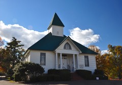 | Bethel Springs Presbyterian Church | building | 1983 | 83003054 |
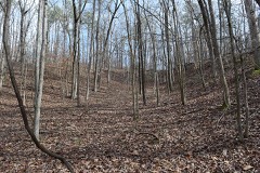 | Big Hill Pond Fortification | site | 1998 | 98001182 |
Every wildfire the federal occurrence database records inside this county: 890 of them, burning about 6,929 acres. 6 started naturally and 316 were recorded as arson. Each settlement page carries the fires within five miles of it.
| Reported cause | Fires |
|---|---|
| Debris and open burning | 402 |
| Arson/incendiarism | 316 |
| Missing data/not specified/undetermined | 65 |
| Equipment and vehicle use | 47 |
| Power generation/transmission/distribution | 18 |
| Other causes | 16 |
| Misuse of fire by a minor | 10 |
| Natural | 6 |
| Recreation and ceremony | 5 |
| Smoking | 3 |
| Railroad operations and maintenance | 2 |
The five largest, by the area the report gives. Five of them were set deliberately.
| Date | Cause | Size | Reported by | Name on the report |
|---|---|---|---|---|
| 16 March 2007 | Debris and open burning | 216 acres | Tennessee Division of Forestry | SPOTTIN FIRE |
| 8 March 2010 | Debris and open burning | 157 acres | Tennessee Division of Forestry | SOD FARM |
| 13 October 2000 | Arson/incendiarism | 147 acres | Tennessee Division of Forestry | not named |
| 7 January 2006 | Arson/incendiarism | 144 acres | Tennessee Division of Forestry | not named |
| 28 March 2003 | Missing data/not specified/undetermined | 120 acres | Tennessee Division of Forestry | ESSARY SPRINGS FIRE #2 |
| 12 April 2015 | Arson/incendiarism | 115 acres | Tennessee Division of Forestry | ESSARY SPRINGS ROAD |
| 23 November 2001 | Arson/incendiarism | 85 acres | Tennessee Division of Forestry | not named |
| 26 March 2001 | Arson/incendiarism | 83 acres | Tennessee Division of Forestry | not named |
Every settlement page carries the fires within five miles of it - see the settlement index below.
The NOAA Storm Events Database holds 235 reports for this county, causing 19 deaths, 144 injuries and about $75,502,610 in recorded property damage. Each settlement page carries the reports that name it.
| Kind of event | Reports |
|---|---|
| Thunderstorm Wind | 109 |
| Hail | 74 |
| Flash Flood | 23 |
| Tornado | 21 |
| Lightning | 6 |
| Flood | 2 |
The most serious of them, by death, then injury, then recorded damage. The accounts are quoted exactly as the forecast office filed them.
| When | Event | Place named | Harm | What the report says |
|---|---|---|---|---|
| March 2023 | Tornado (EF3) | Rose Creek | 9 killed, 21 hurt, $20,000,000 | This tornado crossed from Hardeman County into McNairy County and moved east-northeast along Skipper Creek, intensifying as it moved into the Rose Creek area. A swath of significant damage was surveyed along Rose Creek Road from Talley Road to King Road. Tree damage was widespread and several homes were severely damaged. A single-wide manufactured home was destroyed on Rose Creek Road, killing all four occupants. Maximum wind speeds in this area were estimated at 125 mph. The tornado briefly weakened as it approached Highway 64 west of Selmer. Widespread tree damage and sporadic damage to structures were noted along Bud Long Road, Highway 64, and John Moore Road, with several utility poles snapped along Highway 64. A church was damaged at Highway 45 and Dowty Road. The glass in the foyer was blown out and some damage to the siding was observed. Just north of the church, a metal building was destroyed and several utility poles were snapped. More significant damage was noted along Main Street just south of Hopkins Street in the Bethel Springs area. Several homes sustained significant damage. This is the same area affected by a tornado a few hours prior with a few of these properties sustaining damage from both tornadoes. The tornado continued to the east-northeast, damaging trees and utility poles on Murray School Road and numerous homes along Bethel Purdy Road. The Community Center on Purdy Beauty Hill Road was completely destroyed and a nearby home suffered severe damage. The tornado intensified as it followed Old Stage Road. Widespread damage to trees, powerlines, and homes was observed from Dogwood Lane to Leapwood Enville Road. Several homes were completely destroyed and four fatalities occurred in this area. Additional home and tree damage was observed along Puron and Neely Sharp Roads with another area of more significant damage near Highway 22 and Winding Ridge Road where another fatality occurred. In total, nearly 200 structures were damaged in McNairy County between this tornado and the EF-2 that occurred a couple of hours earlier, 91 of which were total losses. The tornado weakened as it moved into Hardin County. Peak winds in McNairy County from this tornado were estimated at 155 mph. |
| April 2025 | Tornado (EF3) | Rose Creek | 5 killed, 14 hurt, $11,000,000 | The tornado developed near Locke Road and quickly intensified as it moved to the east-northeast just north of Sulphur Springs. It produced mainly tree damage along Eldie Foster and Nelson Store Roads. The tornado produced significant damage to several homes on Sulphur Springs Road near Dee Moore Road and destroyed a manufactured home. The tornado then moved over a more forested area south of Ervin Hester Road, but a well-defined swath of downed trees can be seen via aerial imagery. The tornado intensified as it moved across Highway 45 into Selmer, damaging numerous homes on the western and northern portions of town. The most significant damage was surveyed along New Bethel Road and Adams Extension, where several homes were destroyed. Wind speed estimates in this area were 145-160 mph, corresponding to a high-end EF3 rating. Between these locations, damage to homes and trees was generally in the EF2 range. Significant damage continued to be observed east of the Illinois Central Railroad tracks along Bethesda Purdy Road, where a home suffered major roof damage and a metal building was destroyed. The tornado tracked further northeast, producing minor to significant tree damage, but affected a few more homes and outbuildings along Purdy Road and Airport Road. Aerial imagery revealed significant tree damage between Purdy Road and Barnes Road, with damage to trees and outbuildings noted near the intersection of Old Stage Road and Leapwood Enville Road. Consistent tree damage continued as the tornado crossed Puron Road, Neely Sharp Road, and Highway 22 north of Adamsville before crossing into Hardin County. Peak winds were estimated at 160 mph. |
| March 1991 | Tornado (F3) | not stated | 4 killed, 45 hurt, $25,000,000 | no account filed |
| October 2019 | Thunderstorm Wind | Eastview | 1 killed, $2,690,000 | Straight line winds caused significant damage across McNairy County. 880 homes were damaged and 21 homes were destroyed. Trees and power lines were knocked down across the county. Adamsville was the hardest hit area of the county while Milledgeville and Miche also sustained damage. A man was killed by a falling tree in Milledgeville. |
| February 1971 | Tornado (F2) | not stated | 36 hurt, $2,500,000 | no account filed |
| April 1957 | Tornado (F3) | not stated | 11 hurt, $250,000 | no account filed |
| May 2010 | Tornado (EF2) | Falcon | 10 hurt, $7,300,000 | A tornado touched down near the intersection of Sulphur Springs Road and Steadman Road, southwest of Selmer, and tracked northeast. This tornado was spawned from the same cell that produced a tornado from near Ashland, Mississippi to near Pocahontas, Tennessee and just west of Ramer, Tennessee in McNairy County. Tree and minor roof damage was noted at the beginning of the track. The tornado tracked further to the northeast and hit northern parts of Selmer. A carport failed due to fallen trees at the Christmas Tree Farm. A large home was moved off the foundation as well as a double wide mobile home. A single wide trailer was destroyed and wrapped around a tree. Total collapse of a few buildings occurred as well. Large trees were knocked down and minor roof damage was noted. The tornado then tracked further to the northeast and hit Bethesda and Purdy. Two churches were destroyed. A brick home sustained major roof damage while a horse barn was completely destroyed. The tornado tracked further to the northeast and hit the town of Good Hope. Two homes were destroyed. The tornado continued to the northeast crossing into Hardin County just to the southwest Milledgeville. At least ten injuries occurred in McNairy County from the tornado. In total, 22 homes were completely destroyed with 59 homes sustaining major damage. At least minor damage occurred to 219 homes. Fifteen mobile homes were destroyed and eleven sustained major damage. Twenty mobile homes received minor damage. Several other buildings and outbuildings were damaged or destroyed as well. |
| January 1959 | Tornado (F2) | not stated | 3 hurt, $250,000 | no account filed |
| April 1970 | Tornado (F2) | not stated | 3 hurt, $25,000 | no account filed |
| March 1984 | Thunderstorm Wind | not stated | 1 hurt | no account filed |
| July 2020 | Flash Flood | Selmer | $2,000,000 | A levee broke outside of Selmer toward Purdy which, when combined with very heavy rainfall of up to eight inches, resulted in widespread flash flooding. Twenty people were rescued. Ten homes and 50 businesses were flooded and damaged. Roads and bridges were also damaged. |
| December 2015 | Tornado (EF4) | Chewalla | $1,230,000 | The tornado moved into McNairy County from Hardeman County and began weakening. Around 15 homes were damaged or destroyed south of Selmer. The last observed damage was near Highway 45 on the southeast edge of Selmer. |
| March 2023 | Tornado (EF2) | Bethel Spgs | $350,000 | NWS damage surveys concluded that a tornado touched down just south of Bethel Springs on Main Street around 9:30 PM CDT on the evening of March 31, 2023. The tornado picked up in size and intensity as it moved northeast toward Murray School Road where a double-wide manufactured home was completely destroyed. EF-2 damage continued northeast on Bethel Purdy Road where wooden power poles were snapped. A nearly 5-mile-long swath of EF-1 damage was noted up through Good Hope Church Road where more structures were significantly damaged. EF-2 damage was observed at several locations off Good Hope Church Road, including significant roof damage to a single-family residence along with bent metal electrical transmission poles. Widespread tree damage continued for 10 miles to the northeast consistent with EF-1 wind ratings as the tornado crossed into Hardin County. Peak winds in McNairy County from this tornado were estimated at 115 mph. |
| March 1997 | Tornado (F2) | Ramer | $300,000 | no account filed |
| May 2010 | Flash Flood | Finger | $250,000 | Very heavy rain fell across McNairy County producing widespread flash flooding. The city park in Selmer was flooded. Numerous roads and bridges were flooded or washed out. The flash flooding transitioned to flooding as the heavy rain caused rivers to rapidly rise and overflow their banks. |
| February 2008 | Tornado (EF1) | Ramer | $250,000 | The tornado touched down near Highway 57 just east of Ramer. Several large trees were knocked down in the area. The tornado traveled non-continuously toward the northeast producing more damage in the town of Eastview where one business was destroyed and a second business was damaged along U.S. Highway 45. The tornado continued northeast and traveled through a forested area where numerous trees were blown down. the tornado continued across Highway 142. Two homes received roof damage and one mobile home was destroyed in the area. The tornado was rated an EF-1 with wind speeds estimated around 105 mph and a width of around 150 yards. |
| May 1999 | Thunderstorm Wind | Selmer | $250,000 | More than 40 homes were damaged and a dozen mobile homes were damaged or destroyed. Several trees were blown down. |
| October 1980 | Tornado (F1) | not stated | $250,000 | no account filed |
| May 1961 | Tornado (F2) | not stated | $250,000 | no account filed |
| February 2023 | Tornado (EF1) | Ramer | $150,000 | The first identifiable damage from this tornado began on Friendship Road north northwest of Ramer. A detached metal and wood garage at this location was destroyed with numerous hardwood and softwood trees uprooted and snapped on the property. The tornado moved to the northeast and caused damage to a property on Teague Lane. Another large garage made of metal and wood was destroyed. A single-family residence on this property sustained a significant loss of roof material. The tornado moved eastward along Feddie Davis Road and caused additional hardwood and softwood tree damage. The tornado likely dissipated in a wooded area west of Highway 45. Peak winds were estimated at 105 mph. |
| May 2001 | Tornado (F1) | Ramer | $100,000 | The tornado started near Ramer and tracked northeast. The tornado dissipated just after crossing US Highway 45. Two homes had major damage with one house moving off its foundation. Several other homes had minor damage. A recreational vehicle was tipped over. |
| July 2003 | Thunderstorm Wind | Countywide | $75,000 | At least 20 homes were damaged in the Ramer area. Numerous trees and power lines were knocked down across the county. |
| March 2023 | Thunderstorm Wind | Old Lawton | $50,000 | The rear flank downdraft of the EF-2 tornado that tracked from near Bethel Springs toward Morris Chapel caused straight-line damage on Good Hope Church Road, Sam Kirby Road, and Puron Road. Trees were uprooted and snapped. A church roof was heavily damaged. |
| April 2021 | Lightning | Selmer | $50,000 | Multiple fire departments called in to extinguish a fire at a business on Mulberry Avenue in Selmer. The fire was believed to be started by lightning. |
| March 2015 | Flash Flood | Needmore | $50,000 | Heavy rain caused flash flooding across parts of McNairy County near Michie. The roadway around a bridge on Joe Dillion Road was washed out. A six foot diameter, 50 foot long culvert was washed out at Brown Branch Creek and Goadman Lane. In addition, Pleasant Site Road and Taylor Road just of Highway 57 was closed due to flooding. |
| February 2001 | Thunderstorm Wind | Selmer | $50,000 | A mobile home was destroyed in Lawton. Numerous trees and power lines were knocked down between Selmer and Adamsville. |
| July 2000 | Lightning | Selmer | $50,000 | A home was destroyed by a fire started by lightning. |
| October 1996 | Flash Flood | Purdy | $50,000 | no account filed |
| May 2017 | Thunderstorm Wind | Michie | $30,000 | Tree down on a house in Highway 22 in Michie. |
| August 2004 | Thunderstorm Wind | Adamsville | $30,000 | Some houses had roof damage. Two businesses had roof damage. Trees and power lines were also blown down. |
| May 1997 | Lightning | Adamsville | $30,000 | A house was badly damaged by a fire started by lightning. Three persons in the house were killed in the fire. |
| March 2006 | Thunderstorm Wind | Bethel Spgs | $25,000 | Two large barns were totally destroyed. Two houses were also damaged. Some trees and power lines were blown down. Part of a metal building was blown across Highway 64 in Selmer. |
| August 2000 | Lightning | Adamsville | $25,000 | A lightning strike destroyed one of three wells providing water to people in Adamsville. Some people in Adamsville went for four days without water. |
| January 1999 | Thunderstorm Wind | Selmer | $25,000 | A barn was destroyed and a fence was blown over. Several trees were also knocked down. |
| April 1998 | Thunderstorm Wind | Selmer | $25,000 | Several business had their roofs blown off. Numerous trees and power lines were knocked down. At least one tree fell on a house. |
| October 1980 | Tornado (F1) | not stated | $25,000 | no account filed |
| July 2023 | Thunderstorm Wind | Bethel Spgs | $20,000 | Several trees were knocked down across northern McNairy County. Additionally, trees were down on power lines in Bethel Springs. |
| January 1999 | Thunderstorm Wind | Countywide | $20,000 | One home was damaged near Selmer. Several trees and power lines were blown down over the county. |
| February 1996 | Lightning | Selmer | $20,000 | no account filed |
| March 1996 | Thunderstorm Wind | Adamsville | $20,000 | no account filed |
| May 2010 | Tornado (EF0) | Ramer | $15,000 | A tornado briefly touched down near Dan Head Road, west of Ramer. Several trees were knocked down in the area. Minor roof damage occurred to a mobile home. This tornado was spawned by the same cell that produced damage from near Ashland Mississippi to near Pocahontas, Tennessee. This same cell would go onto produce damage near Selmer. |
| May 1999 | Thunderstorm Wind | Ramer | $15,000 | Some structures were damaged. A few trees and power lines were blown down. |
| April 2025 | Thunderstorm Wind | Rose Creek | $10,000 | Several trees were uprooted and trunks snapped along Locke Rd, Eldie Roster Rd and Dee Moore Rd associated with the rear flank downdraft of the Selmer tornado path. |
| April 2022 | Thunderstorm Wind | Selmer | $10,000 | Widespread tree damage. Some structures suffered rood damage across town. |
| July 2014 | Flash Flood | Falcon | $10,000 | Thunderstorms trained over McNairy County for several hours. As a result, flash flooding occurred in Selmer. At least one mobile home was surrounded by flood water trapping the resident. In addition, flooding occurred along Sulpher Springs Road where a home also became surrounded by flood waters. An unknown number of people were trapped in the home. |
| May 2010 | Tornado (EF3) | Chewalla | $10,000 | A tornado crossed into McNairy County from Hardeman County. The tornado briefly traveled northeast before lifting near Highway 57. Several trees and power lines were knocked down in the area. This storm would later spawn a couple of tornadoes further northeast in McNairy County. |
| July 2003 | Thunderstorm Wind | Countywide | $10,000 | Many trees and power lines were knocked down across the county. |
| April 2003 | Thunderstorm Wind | Adamsville | $10,000 | Numerous trees were blown down. |
| July 2002 | Thunderstorm Wind | Stantonville | $10,000 | Some trees and power lines were knocked down. |
| July 2002 | Thunderstorm Wind | Rose Creek | $10,000 | Some shingles, power lines and tree limbs were blown down. |
| February 2001 | Thunderstorm Wind | Countywide | $10,000 | Several trees were blown down. |
| October 2001 | Thunderstorm Wind | Countywide | $10,000 | Numerous trees were knocked down across the county. |
| September 2001 | Thunderstorm Wind | Ramer | $10,000 | A few trees and power lines were blown down. |
| February 2000 | Thunderstorm Wind | Selmer | $10,000 | Several trees were knocked down. |
| May 2000 | Thunderstorm Wind | Ramer | $10,000 | Some shingles were blown across a road. Several power lines were knocked down. |
| August 2000 | Thunderstorm Wind | Selmer | $10,000 | An outbuilding was blown down in Stantonville. Several trees were also knocked down. |
| May 1999 | Thunderstorm Wind | Countywide | $10,000 | Trees and power lines were knocked down across the county. |
| April 1999 | Thunderstorm Wind | Selmer | $10,000 | Several large trees and large signs were blown down. |
| May 1999 | Thunderstorm Wind | Adamsville | $10,000 | Several trees and power lines were blown down. |
| June 1998 | Thunderstorm Wind | Countywide | $10,000 | Numerous trees and power lines were knocked down across the county. |
The Survey's mineral resources record lists 21 workings inside this county. 5 still produce and 16 are closed or unrecorded. Each settlement page carries the workings within five miles of it.
| Commodity | Workings |
|---|---|
| Clay | 14 |
| Sand and Gravel, Construction | 7 |
The least common of them first, because a county's hundredth gravel pit says nothing its first ten did not.
| Where | Site | Commodity | Status | Recorded |
|---|---|---|---|---|
| #5 McKensie - Swiney Pit | Sand and Gravel, Construction | Producer | Unconsolidated Sediments | |
| Adamsville Mine | Sand and Gravel, Construction | Producer | ||
| Jones Pit | Sand and Gravel, Construction | Producer | Unconsolidated Sediments | |
| Jones Pit | Sand and Gravel, Construction | Past Producer | Sedimentary | |
| Michie Mine | Sand and Gravel, Construction | Producer | ||
| Number 5 McKensie-Swiney Pit | Sand and Gravel, Construction | Past Producer | Sedimentary | |
| Number 5 McKensie-Swiney Pit | Sand and Gravel, Construction | Producer | ||
| Adamsville Prospect | Clay | Occurrence | ||
| Burn's Hill Prospect | Clay | Prospect | ||
| County Line Prospect | Clay | Occurrence | ||
| Guys Area Prospect | Clay | Occurrence | ||
| J.F. Basham Farm Prospect | Clay | Prospect | ||
| North Adamsville Prospect | Clay | Occurrence | ||
| Northeast Selmer Prospect | Clay | Occurrence | ||
| Rose School Prospect | Clay | Occurrence | ||
| Selmer Prospect | Clay | Occurrence | ||
| Selmer Prospect | Clay | Occurrence | ||
| Southeast Selmer Prospect | Clay | Occurrence | ||
| Southwest Selmer Prospect | Clay | Occurrence | ||
| W.H. Wolf Farm Prospect | Clay | Occurrence | ||
| West Selmer Prospect | Clay | Occurrence |
Named settlements recorded in the Geographic Names Information System, each with the topographic sheets covering it. Villages, hamlets and abandoned places alike. Each is shown with the nearest named watercourse or landform and the survey quadrangle it falls on.
District 1 · 38315 · Near Major Hill Hollow · Mount Peter quadrangle
9 sheets, 1936 to 1986
District 2 · 38310 · Near Winding Ridge · Leapwood quadrangle
9 sheets, 1936 to 1986
No longer a settlement
District 7 · 38379 · On Statonville Branch · Stantonville quadrangle
10 sheets, 1936 to 1986
District 5 · 38375 · On Gilmore Branch · Rose Creek quadrangle
9 sheets, 1951 to 1986
The vanished settlements of McNairy County: the places named above that are no longer on the map.