BlockBefore
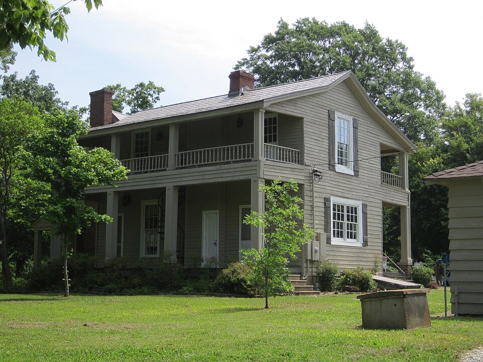
Photograph of Mt. Airy
Photograph by Thomas R Machnitzki (thomas@machnitzki.com), CC BY 3.0. Via Wikimedia Commons.

Mt. Airy

Listed on the National Register of Historic Places in 2002.

From the record

“Airy is a historic house in Cordova, Tennessee. It was built in 1835 for Asbury Crenshaw, his son Timothy, and their relatives.”

Wikipedia article Mt. Airy (Cordova, Tennessee), CC BY-SA 4.0.

One of 216 National Register listings published here for Shelby County · listed in 2002 · category: Building.

Sources: the Wikipedia article · the National Register database, National Park Service · the Wikipedia article

The listing

  • Address. 10700 Latting Rd., Cordova, 38016
  • When was it listed? February 2002
  • Category. building
  • District. District 2
  • National Register reference number. 02000011 - assigned by the National Park Service when the property was listed.

Fires near this property

1 since 2000

Regional context, not property-specific evidence. The federal wildfire occurrence database lists 1 fire within 5 miles of Mt. Airy in 2000, burning about 3 acres in total. None started naturally. None was recorded as arson. Distance is straight-line from the map coordinates, so a fire counted here may appear on a neighbouring settlement's page as well.

Reported cause Fires
Missing data/not specified/undetermined1

The most recent of them, most recent first, with the day each was reported and the service that recorded it.

DateCause SizeReported by Name on the report
8 October 2000Missing data/not specified/undetermined3.0 acresTennessee Division of Forestrynot named

Every fire recorded in Shelby County

Mines and quarries near this property

9 within 5 miles

Regional context, not property-specific evidence. The federal mineral resources record lists 9 workings within 5 miles of Mt. Airy: 4 producers, 4 past producers, 1 occurrence. 4 still produce. What was taken out: Sand and Gravel, Construction, Clay. Distance is straight-line from the map coordinates, so a quarry counted here may appear on a neighbouring settlement's page as well.

Where SiteCommodity StatusRecorded
Eads ProspectClayOccurrence
#2 Bragg and Sons PitSand and Gravel, ConstructionProducerUnconsolidated Sediments
#3 Brown PitSand and Gravel, ConstructionPast ProducerUnconsolidated Sediments
#4 Highway 64 PitSand and Gravel, ConstructionProducer1971
No. 3 Brown PitSand and Gravel, ConstructionPast Producer
Number 2 Bragg and Sons PitSand and Gravel, ConstructionPast ProducerSedimentary
Number 2 Bragg and Sons PitSand and Gravel, ConstructionProducer
Number 4 Highway 64 PitSand and Gravel, ConstructionPast ProducerSedimentary
Number 4 Highway 64 PitSand and Gravel, ConstructionProducer

Every working recorded in Shelby County

Storms near this property

45 since 1993

Regional context, not property-specific evidence. The National Weather Service names Cordova, the town this property stands in, in 45 storm reports between 1993 and 2025: 21 hail, 13 thunderstorm wind, 7 flash flood, 2 tornado. No death or injury is recorded in these reports. Each account below is quoted exactly as the forecast office filed it, from the NOAA Storm Events Database, and each date opens the federal record of that event.

WhenEvent Place namedHarm What the report says
January 1999Tornado (F1)Cordova$300,000The tornado started in the eastern edge of Cordova and tracked northeast. Two homes were destroyed. Several homes, two businesses and one school sustained roof damage. Several outbuildings were also destroyed.
May 2017Thunderstorm WindCordova$100,000External warning siren destroyed at Bazemore Road and Forest Hill Irene.
January 2013Flash FloodCordova$100,000Heavy rain caused flash flooding across parts of Memphis. The Poplar Avenue and International Place intersection was flooded in East Memphis. Airways Road and Swinnea Road near Memphis International were flooded. Vehicles were stuck in deep water near Walnut Grove Road and Interstate 240 in East Memphis. Water was as deep as the windows of a stalled car at Timber Creek Drive and Walnut Bend Road in Cordova.
June 2006Tornado (F1)Cordova$100,000An F1 tornado touched down near Wood Sage Cove in the Franklin Farms Subdivision off Houston Levee Road 1 mile south of Lakeland. This is just south of Highway 64. The tornado then tracked northeast across Tall Hickory Drive and then lifted. In addition to the tornado there was also straight line wind damage in the vicinity. About 20 homes in the Franklin Farms subdivision were damaged. Some homes had roofs partially ripped off. An SUV also had windows broken out of it.
June 2023Thunderstorm WindCordova$50,000Six power poles were severely bent on Germantown Parkway south of Macon Road in Cordova.
March 2012Flash FloodCordova$50,000Very heavy rain resulted in flash flooding across parts of Memphis and Bartlett. Range Line Road and the intersection of North Watkins and Signal Street in Frayser were flooded. The intersections of Parkview and Raleigh Lagrange in Raleigh were also flooded. In Downtown Memphis a storm drain pipe burst due to excessive rainfall and flooded the basement of a courthouse on Adams Avenue. A little further to the east the intersection of Vollintine Avenue and Hawthorne Street in Midtown was impassable due to high water. Flooding also occurred near the city of Bartlett along Whitten Road to the north of Interstate 40. Vehicles were stranded in the flood waters. Flooding was also reported at the intersection of Covington Pike and Stage Road.
April 2006HailCordova$15,000no account filed
October 1996LightningCordova$10,000no account filed
April 2019Thunderstorm WindCordova$2,000Powerlines down in Cordova.
February 2008Thunderstorm WindCordova$2,000Straight line winds produced minor roof damage to a house in Cordova.
June 2006Thunderstorm WindCordova$2,000Some trees were knocked down near the Lakeland area.
April 1998HailCordova$1,000no account filed
October 2003HailCordova$150no account filed
May 2003HailCordova$110no account filed
April 1994HailCordova$50no account filed
June 2006Flash FloodCordova$10Heavy rain caused one lane of Lenow Road 4 miles south of Lakeland to be flooded.
August 2004HailCordova$10no account filed
May 2002HailCordova$10no account filed
August 2000HailCordova$10no account filed
July 2000HailCordova$10no account filed
April 2025HailCordova-Quarter sized hail at NWS Memphis. Lasted 2-3 minutes.
April 2025Thunderstorm WindCordova-Damage to the ABC Behavior Therapy Building in Cordova.
April 2025Flash FloodCordova-Walnut Grove Road before Timber Creek Dr flooded with water up to the mailboxes along the side of the road.
January 2022Thunderstorm WindCordova-Straight-line winds damaged a business sign near Dexter Road and Germantown Parkway.
October 2019Heavy RainCordova-Heavy rain resulted in water on area roadways. A young motorist died as a result of hydroplaning.
July 2018HailCordova-Quarter size hail around Houston Levee Road and Wolf River.
July 2013Thunderstorm WindCordova-Straight line winds knocked large trees down on Raleigh-LaGrange Road.
June 2013Thunderstorm WindCordova-Straight line winds knocked four power poles down near the intersection of Macon Road and Berryhill Road. Several trees and fences were also knocked down in the area. Tree branches were knocked down as far west as the intersection of Germantown Road and Macon Road.
June 2011Thunderstorm WindCordova-A 60 mph gust was recorded on a personal weather station in Cordova. A few trees were knocked down near Walnut Grove Road and Sanga Road.
June 2011HailCordova-Numerous large hail reports ranging from quarter to pool ball size were reported in the Cordova and Germantown areas.
March 2010Thunderstorm WindCordova-Several large tree branches were knocked down at the intersection of Sanga Road and Macon Road in Cordova.
May 2010Thunderstorm WindCordova-Winds gusted to 60 mph at the National Weather Service Office in Memphis.
April 2010HailCordova-Quarter to golf ball size hail fell in the Cordova area. Golf ball size hail was reported at the National Weather Service Office.
May 2010HailCordova-Public reported golf ball size hail at Germantown Parkway and Trinity Road in Cordova.
May 2010HailCordova-Public reported quarter size hail at Germantown Parkway and Cordova Road in Cordova.
May 2010HailCordova-Nicked size hail fell at the National Weather Service office at the Agricenter International complex near Walnut Grove Road and Germantown Parkway.
May 2010Flash FloodCordova-Heavy rain produced flash flooding across parts of Shelby County. The intersection of Raleigh Lagrange and Dexter Road was flooded. The parking lots and breezeways were flooded at the Greenbrook Apartments on Macon Road. Street flooding also occurred on Appling Road near the Bellevue Baptist Church.
May 2010HailCordova-Penny size hail fell at the National Weather Service Office.
May 2010HailCordova-Quarter size hail fell at the National Weather Service Office.
September 2009Flash FloodCordova-Heavy rain flooded a low water crossing at the Agricenter International Complex. Water was at least 18 inches high. A car became stranded in the water when the motorist tried to drive through the flood water. Minor flooding occurred in the bottom floor of the Agricenter building as well.
June 2009Thunderstorm WindCordova-Straight line winds knocked down trees at the intersection of Dexter Road and Germantown Road in Cordova.
January 2008Flash FloodCordova-Heavy rain produced flash flooding at the intersection of Walnut Grove Road and Germantown Parkway in Cordova.
April 2025HailCordova-no account filed
April 2014HailCordova-no account filed
May 1993HailCordova-no account filed

Every storm recorded in Shelby County

Map coverage status

No historic map-sheet match is published for this property yet. That does not mean no map exists. This record needs a coordinate-quality review before it can be joined to a sheet boundary. Browse the county's mapped places while that work is pending.

Listed places nearby

6 within 8 miles

Other National Register properties close enough to walk or drive between, ordered by distance from this one. Both positions come from the same geocoding pass that matched these properties to their map sheets.

Photograph PropertyDistance Listed
Davies Manor4.0 miles1975
Cordova School4.5 miles1995
Walter Granville Allen House4.8 miles1990
Wells School4.9 miles1995
Greenlevel5.9 miles1987
John H. McFadden House7.4 miles1994

Sources for this property

National Archives recordThe nomination case file for reference 02000011 in Record Group 79.
Wikipedia articleCommunity-written account of this property, licensed CC BY-SA.
Shelby CountyAll 216 listed properties in this county.

Provenance

  • Listing record. National Park Service National Register of Historic Places, listed-properties dataset, current to 2026-05-22.
  • Map join. Address geocoded through the United States Census geocoder, then tested against the published boundary of every sheet in the USGS Historical Topographic Map Collection.
  • How this page is made. Listing fields come from federal records; map-sheet coverage is a labelled coordinate-to-boundary calculation, not a source-field claim.
  • Wildfire. Short, Karen C. 2022. Spatial wildfire occurrence data for the United States, 1992-2020 [FPA_FOD_20221014]. 6th Edition. Fort Collins, CO: Forest Service Research Data Archive. https://doi.org/10.2737/RDS-2013-0009.6 Collected with United States Government funding and usable without additional permissions or fees.
  • Mines and quarries. USGS Mineral Resources Data System (MRDS) https://mrdata.usgs.gov/mrds/ A work of the United States government, no copyright under 17 U.S.C. 105.
  • Storms. NOAA National Centers for Environmental Information, Storm Events Database https://www.ncei.noaa.gov/stormevents/ A work of the United States government, no copyright under 17 U.S.C. 105. Narratives are quoted verbatim from the National Weather Service report and are not edited or summarised.