 Block
From the record
One of 22 National Register listings published here for Franklin County · listed in 2015 · category: Building · built in 1933.
Sources: the National Register database, National Park Service
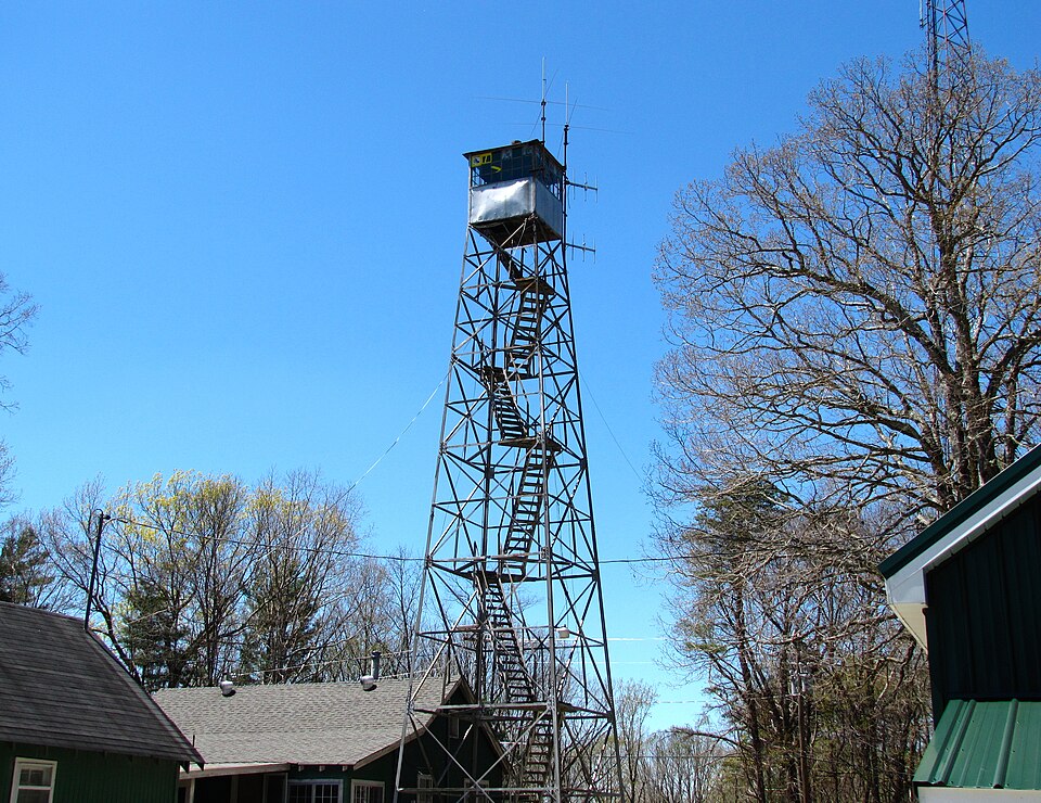
Built in 1933. Listed on the National Register of Historic Places in 2015.
One of 22 National Register listings published here for Franklin County · listed in 2015 · category: Building · built in 1933.
Sources: the National Register database, National Park Service
Regional context, not property-specific evidence. The federal wildfire occurrence database lists 95 fires within 5 miles of Sewanee Fire Lookout Tower between 1997 and 2020, burning about 1,416 acres in total. None started naturally. 40 were recorded as arson. Distance is straight-line from the map coordinates, so a fire counted here may appear on a neighbouring settlement's page as well.
| Reported cause | Fires |
|---|---|
| Arson/incendiarism | 40 |
| Debris and open burning | 39 |
| Equipment and vehicle use | 8 |
| Missing data/not specified/undetermined | 6 |
| Recreation and ceremony | 1 |
| Smoking | 1 |
The most recent of them, most recent first, with the day each was reported and the service that recorded it.
| Date | Cause | Size | Reported by | Name on the report |
|---|---|---|---|---|
| 19 September 1999 | Arson/incendiarism | under an acre | Tennessee Division of Forestry | not named |
| 15 September 1999 | Smoking | under an acre | Tennessee Division of Forestry | not named |
| 10 September 1999 | Debris and open burning | 4.0 acres | Tennessee Division of Forestry | not named |
| 5 June 2011 | Equipment and vehicle use | under an acre | Tennessee Division of Forestry | MYERS POINT |
| 5 May 2015 | Debris and open burning | 2.8 acres | Tennessee Division of Forestry | WORMWOOD LANE |
| 5 May 2001 | Debris and open burning | 18 acres | Tennessee Division of Forestry | not named |
| 3 May 2001 | Missing data/not specified/undetermined | 3.0 acres | Tennessee Division of Forestry | not named |
| 26 May 2001 | Arson/incendiarism | 7.0 acres | Tennessee Division of Forestry | not named |
Regional context, not property-specific evidence. The federal mineral resources record lists 5 workings within 5 miles of Sewanee Fire Lookout Tower: 3 past producers, 1 prospect, 1 producer. 1 still produces. What was taken out: Sand and Gravel, Construction, Silica, Manganese. Distance is straight-line from the map coordinates, so a quarry counted here may appear on a neighbouring settlement's page as well.
| Where | Site | Commodity | Status | Recorded |
|---|---|---|---|---|
| King Prospect | Manganese | Prospect | ||
| Estill Springs Pit Number 77 | Sand and Gravel, Construction | Past Producer | Sedimentary | |
| Jump Off Mine No. 1 | Sand and Gravel, Construction | Past Producer | ||
| Sewanee Mine | Silica | Past Producer | ||
| Sewanee Silica Company Pit | Silica | Producer | Sandstone |
Regional context, not property-specific evidence. The National Weather Service names Sewanee, the town this property stands in, in 15 storm reports between 1996 and 2021: 10 thunderstorm wind, 3 hail, 1 tornado, 1 lightning. No death or injury is recorded in these reports. Each account below is quoted exactly as the forecast office filed it, from the NOAA Storm Events Database, and each date opens the federal record of that event.
| When | Event | Place named | Harm | What the report says |
|---|---|---|---|---|
| December 2021 | Thunderstorm Wind | Sewanee | $10,000 | Sewanee Police reported numerous trees and some power lines down on University Avenue. Time estimated by radar. |
| January 2006 | Lightning | Sewanee | $10,000 | Lightning struck a satellite dish which travelled along wiring into electronic equipment in a house which sparked a fire producing considerable damage to the interior of the home. |
| June 2011 | Thunderstorm Wind | Sewanee | $9,000 | Large trees and tree limbs were knocked down on the campus of the University of the South. |
| July 2012 | Thunderstorm Wind | Sewanee | $4,000 | Thunderstorm winds knocked at least 8 trees down and caused a power outage. Time estimated by radar. |
| July 2021 | Thunderstorm Wind | Sewanee | $1,000 | A couple of trees were knocked down along Roarks Cove Road. Time estimated by radar. |
| February 2009 | Thunderstorm Wind | Sewanee | $1,000 | Thunderstorm winds blew down large tree limbs onto a road in Sewanee. Time estimated. |
| June 2008 | Thunderstorm Wind | Sewanee | $500 | One tree was downed due to thunderstorm winds associated with a weak downburst. The county sheriff estimated a wind gust of 50 mph. |
| April 2018 | Thunderstorm Wind | Sewanee | - | Trees were knocked down near Sewanee Highway around Cowan and Sewanee. |
| April 2017 | Hail | Sewanee | - | Quarter sized hail was reported in Sewanee. |
| July 2015 | Thunderstorm Wind | Sewanee | - | A few trees were downed by thunderstorm winds along Sherwood road, just south of Highway 41. |
| December 2008 | Thunderstorm Wind | Sewanee | - | Thunderstorm winds blew trees down on Sewanee Mountain. Exact location unknown and time estimated. |
| April 2005 | Hail | Sewanee | - | Penny size hail was reported. |
| March 2004 | Tornado (F0) | Sewanee | - | A short lived tornado with estimated winds around 70 mph touched down near Sewanee and twisted and uprooted around 50 trees in a heavily wooded area. |
| February 2001 | Thunderstorm Wind | Sewanee | - | Local law enforcement reported a power line down at Sewanee. |
| June 1996 | Hail | Sewanee | - | no account filed |
No historic map-sheet match is published for this property yet. That does not mean no map exists. This record needs a coordinate-quality review before it can be joined to a sheet boundary. Browse the county's mapped places while that work is pending.
Other National Register properties close enough to walk or drive between, ordered by distance from this one. Both positions come from the same geocoding pass that matched these properties to their map sheets.
| Photograph | Property | Distance | Listed |
|---|---|---|---|
| Saint Margaret Mary Catholic Mission | 5.2 miles | 2017 | |
 | Cumberland Mountain Tunnel | 6.8 miles | 1977 |
 | Cowan Depot | 7.9 miles | 1978 |
| National Archives record | The nomination case file for reference 15000116 in Record Group 79. |
| Franklin County | All 22 listed properties in this county. |