 Block
From the record
3 National Register listings published here.
Sources: the National Register database, National Park Service
63 topographic sheets cover 23 settlements here, and 3 properties are on the National Register of Historic Places.
3 National Register listings published here.
Sources: the National Register database, National Park Service
Every property in this county listed on the National Register of Historic Places, with the year it was listed and the federal nomination document.
| Photograph | Property | Type | Listed | Reference |
|---|---|---|---|---|
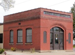 | Burnett County Abstract Company | building | 1980 | 80000109 |
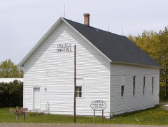 | Daniels Town Hall | building | 2006 | 06001154 |
| Jacobson House and Mill Site | building | 1980 | 80000110 |
Every wildfire the federal occurrence database records inside this county: 1,350 of them, burning about 2,621 acres. 68 started naturally and 88 were recorded as arson. Each settlement page carries the fires within five miles of it.
| Reported cause | Fires |
|---|---|
| Debris and open burning | 402 |
| Missing data/not specified/undetermined | 281 |
| Equipment and vehicle use | 197 |
| Arson/incendiarism | 88 |
| Recreation and ceremony | 86 |
| Fireworks | 71 |
| Natural | 68 |
| Power generation/transmission/distribution | 50 |
| Other causes | 43 |
| Smoking | 40 |
| Misuse of fire by a minor | 21 |
| Railroad operations and maintenance | 3 |
The five largest, by the area the report gives. Two of them were set deliberately.
| Date | Cause | Size | Reported by | Name on the report |
|---|---|---|---|---|
| 1 October 2013 | Missing data/not specified/undetermined | 656 acres | Wisconsin Department of Natural Resources | CRANBERRY |
| 30 March 2000 | Arson/incendiarism | 170 acres | Wisconsin Department of Natural Resources | not named |
| 15 April 2010 | Debris and open burning | 113 acres | Wisconsin Department of Natural Resources | SKOG ROAD |
| 15 April 2004 | Missing data/not specified/undetermined | 71 acres | Wisconsin Department of Natural Resources | not named |
| 29 March 1993 | Debris and open burning | 70 acres | Wisconsin Department of Natural Resources | not named |
| 24 October 1999 | Debris and open burning | 44 acres | Wisconsin Department of Natural Resources | not named |
| 29 July 1999 | Natural | 37 acres | Wisconsin Department of Natural Resources | not named |
| 9 July 2009 | Arson/incendiarism | 36 acres | Wisconsin Department of Natural Resources | GRASS LAKE FIRE |
Every settlement page carries the fires within five miles of it - see the settlement index below.
The NOAA Storm Events Database holds 325 reports for this county, causing 4 deaths, 25 injuries and about $13,329,500 in recorded property damage. Each settlement page carries the reports that name it.
| Kind of event | Reports |
|---|---|
| Hail | 150 |
| Thunderstorm Wind | 147 |
| Tornado | 15 |
| Flash Flood | 7 |
| Lightning | 3 |
| Flood | 3 |
The most serious of them, by death, then injury, then recorded damage. The accounts are quoted exactly as the forecast office filed them.
| When | Event | Place named | Harm | What the report says |
|---|---|---|---|---|
| June 2001 | Tornado (F3) | Grantsburg | 2 killed, 16 hurt, $10,000,000 | The tornado touched down at 806 pm local daylight time 1.5 miles east of Grantsburg and traveled east at an average speed of 40 mph through the village of Siren to the Washburn County line, then continued on to a point 3 miles west of Spooner. The path of the tornado averaged 1/8 to 1/4 mile, but reached its greatest width of ½ mile as it approached Siren around 820 pm, where it did F-3 damage. Two people were killed by the tornado, and there were 16 injuries. Four hundred homes were destroyed, 200 in Siren alone, with 280 homes damaged, and 60 businesses destroyed or damaged. Most of the damage occurred in an 8-block area of Siren. Approximately 14,000 acres of trees were leveled along the tornado path. The two people killed were in Dewey Township, about 14 miles east of Siren. An 80-year-old woman was crushed by a falling wall while trying to get to the basement, and a 77-year-old man was found dead about 100 yards from his demolished home, presumably thrown there by tornado-force winds. Many buildings in the path of the tornado through Dewey Township, including the Dewey Town Hall, were destroyed as well. Power lines, trees, and buildings were also damaged or destroyed at Alpha, Falun, and Mud Hen Lake along the path of the tornado between Grantsburg and Siren. Fifteen cows were lost when a barn collapsed near Falun. Some were killed outright. Others were injured and had to be put down. |
| May 1953 | Tornado (F2) | not stated | 1 killed, 9 hurt, $2,500,000 | no account filed |
| July 2011 | Lightning | Hertel | 1 killed | An eleven year old girl was killed while trying to escape the approaching storm. Lightning struck a tree and the tree fell on the girl, killing her. The tree was so large that it took 20 men to remove it. |
| August 1995 | Thunderstorm Wind | Webster | $250,000 | An isolated severe thunderstorm produced a wicked wet microburst whose violent winds and large hail did considerable damage in Webster (about $250 thousand). Twenty homes and four businesses sustained window and roof damage from the winds and large hail. Two-by-fours were driven through a roof of a house, and many power lines were toppled. Some cars were damaged in Webster by hail three inches in diameter. The hail was described as the size of "billiard balls". |
| August 1995 | Thunderstorm Wind | Webster | $250,000 | Twenty homes and four businesses received window and roof damage from strong thunderstorm winds and large hail. Two-by-fours were driven through the roof of a house. The hail was described as the size of "billiard balls". Some cars were damaged and many power lines were blown down. |
| September 2024 | Thunderstorm Wind | Danbury | $75,000 | Photos and video were received of large trees downed on several properties and on the roadway on Ham Lake Road in Danbury. One house also had a tree fall into the side of the house. Two properties along this road also had docks on Ham Lake that were damaged and flipped. |
| September 1998 | Thunderstorm Wind | Grantsburg | $50,000 | no account filed |
| August 2022 | Thunderstorm Wind | Hertel | $40,000 | Numerous trees were reported down or snapped. The reporter estimates that 80 plus trees were down on their 90 acre property and neighbors had damage to their home due to trees falling on it. |
| August 2024 | Flash Flood | Siren | $30,000 | Burnett County dispatch reported two cars stalled in ponded water on the roadway. |
| July 1987 | Tornado (F0) | not stated | $25,000 | no account filed |
| May 1965 | Tornado (F2) | not stated | $25,000 | no account filed |
| July 2011 | Thunderstorm Wind | Siren Burnett Co Arp | $20,000 | Only one wall was left intact on a camper-trailer. No one was inside at the time. |
| August 2023 | Thunderstorm Wind | Webster | $10,000 | Several branches were down and a small tree had been split in two. Some dock and pontoon boat damage was also reported on Devils Lake. |
| July 2023 | Hail | Siren | $10,000 | Damage to siding, window trim and to the roof of a home were reported due to the golf ball sized hail. |
| July 2011 | Thunderstorm Wind | Danbury | $10,000 | There was shingle damage to a roof on a two-story home along Highway 7. Numerous trees were blown down in the area. |
| June 2010 | Tornado (EF1) | Grantsburg | $10,000 | A tornado crossed the St. Croix River into southwest Burnett County Wisconsin from Pine County Minnesota, about 1.5 miles north of Highway 70, and dissipated about 3.5 miles west-northwest of Grantsburg, WI. The tornado moved into Wisconsin around 9 pm. EF1 damage was assigned due to damage to a home near Grantsburg WI, along with significant tree damage. |
| August 2023 | Thunderstorm Wind | Gaslyn | $5,000 | Photos were received from a spotter on the south end of Benoit Lake showing tree damage to their property. They reported 10 large trees down on their property with one landing on their garage causing minor damage. The spotter also estimated that there were hundreds of trees down in the area between Benoit and Rice lakes. Pea to dim sized hail also fell and was covering the ground in the photos as well. |
| July 2010 | Thunderstorm Wind | Siren | $5,000 | Trees were blown down county-wide. |
| August 2007 | Lightning | Grantsburg | $4,000 | Lightning struck a home, causing electrical damage. The lightning blew out the garage door opener, internet service, cable, telephone, router, two ethernet connections and tripped three circuits, according to the Burnett County Sentinel. The intense lightning storm also caused many small fires to break out in Burnett County, though most were under one acre in size and no property damage was reported. |
| May 2006 | Thunderstorm Wind | Siren | $3,000 | A large shed was blown over. |
| July 2010 | Thunderstorm Wind | Grantsburg | $2,500 | Trees were blown down. In addition, 1.19 inches of rain was measured in an hour's time. |
| August 2023 | Thunderstorm Wind | Four Corners | $2,000 | A power pole was snapped by the winds during the storm. |
| August 2010 | Thunderstorm Wind | Danbury | $1,000 | Power lines were blown down. |
| July 2010 | Thunderstorm Wind | Webb Lake | $500 | A 10-inch diameter healthy oak tree was blown down. |
| July 2010 | Thunderstorm Wind | Webster | $500 | A large healthy oak tree was blown down. In addition, 1.4 inches of rain fell in 30 minutes. |
| August 2010 | Thunderstorm Wind | Siren | $500 | A large tree was blown down onto a roadway. |
| July 2010 | Thunderstorm Wind | Falun | $500 | A 12-inch diameter pine tree was blown down by the winds. |
| May 2025 | Thunderstorm Wind | Siren Burnett Co Arp | - | An eight inch diameter tree branch was down across a lane of Wisconsin Highway 70. |
| May 2025 | Thunderstorm Wind | Coomer | - | Several trees were down onto a roadway. |
| May 2025 | Thunderstorm Wind | Webster | - | Several trees were down on a road along with downed power lines. |
| May 2025 | Thunderstorm Wind | Gaslyn | - | Several six inch diameter branches were broken off trees. |
| July 2025 | Thunderstorm Wind | Alpha | - | County dispatch reported the power company had 15 power poles down along Crosstown Road east-southeast of Grantsburg. |
| July 2025 | Flash Flood | Siren | - | Curb to curb flooding was reported on Wisconsin State Highway 35. |
| July 2025 | Thunderstorm Wind | Siren Burnett Co Arp | - | County dispatch reported a downed tree. |
| July 2025 | Thunderstorm Wind | Siren Burnett Co Arp | - | County dispatch reported multiple trees down in the area. |
| August 2024 | Thunderstorm Wind | Trade River | - | Tree branches up to 1.5 inches in diameter were broken along with power outages. |
| April 2023 | Flood | Riverside | - | Warm temperatures early in April led to rapid snowmelt of a well above normal snowpack across the region. Additionally, heavy rainfall on top of the snowpack led to additional high runoff across the county as well. Roads began to be impacted on the 12th with water overtopping low spots leading to washouts, failed culverts and numerous closed roads. Temperatures cooled during the middle of the month along with a heavy rain/snow event the 16th into the 17th. This allowed the runoff to slow and water levels to drop. Clam Lake rose out of its bank and flooded around 60 homes and cabins around the lake for a time around the 16th and 17th. Multiple communities along with the county issued disaster declarations due to the extent of washed out roads with the worst of the flooding abating by the 25th. Damage estimates were not readily available from the county. |
| July 2023 | Flash Flood | Siren | - | Up to a quarter of a mile of Highway 35 through Siren was covered with 6 to 10 inches of water. |
| July 2023 | Hail | Burnett Co Arpt | - | The ground was completely covered with hail with the largest stones up to golf ball sized. |
| July 2023 | Thunderstorm Wind | Danbury | - | Multiple oak, pine and popple trees with limbs of four to sixteen inches in diameter snapped from trees. The majority of the trees were in good health, but a few had been damaged by last winter's snow and were rotted in spots. |
| August 2023 | Thunderstorm Wind | Gaslyn | - | Several maple, oak and pine trees were blown down in the storm. |
| August 2023 | Thunderstorm Wind | Gaslyn | - | A tree was down onto County Road H north of Highway 70 near Hertel. |
| August 2023 | Thunderstorm Wind | Hertel | - | A photo was received of an eight inch diameter tree that had been snapped. The observer noted that the tree already had a scar on it. |
| July 2023 | Thunderstorm Wind | Siren | - | Five large trees were downed due to damaging winds. These trees were approximately a foot and a half in diameter. Some trees were uprooted while others were snapped in half. |
| May 2022 | Thunderstorm Wind | Danbury | - | A few small trees were down along with a few larger trees that were blocking roads in the area. |
| August 2022 | Thunderstorm Wind | Danbury | - | Four large trees were down across a road. |
| August 2022 | Thunderstorm Wind | Hertel | - | Numerous small to medium-sized trees were down with some snapped at the base and others 20 feet up. Photos showed the trees to be down in a narrow swath about 1000 feet wide with trees laying in multiple directions. |
| June 2022 | Thunderstorm Wind | Hertel | - | Two trees were completely uprooted with many others snapped in half. A cement block shed had also shifted some due to the wind. |
| June 2020 | Flood | Burnett Co Arpt | - | Heavy rainfall led to minor street flooding in front of the Burnett County Court House. |
| July 2020 | Thunderstorm Wind | (Gtg)Grantsburg Muni | - | A small section of roof was torn off a hanger at the Grantsburg Airport. |
| July 2020 | Thunderstorm Wind | Gaslyn | - | The tops of numerous trees were broken off the trunk several feet off the ground and landed on a home. |
| July 2020 | Thunderstorm Wind | Gaslyn | - | Several large pine trees and branches were downed during the storm. Additionally, one side of a weighted dock was flipped over. |
| July 2019 | Flash Flood | Gaslyn | - | Minor flooding was reported after 1.72 inches of rain fell in about an hour and 15 minutes. |
| July 2019 | Flash Flood | Siren | - | A report and photos of flash flooding was received via social media. Cars were driving through 6 to 12 inches of water along Wisconsin Highway 35 at Djock Street. |
| July 2019 | Thunderstorm Wind | Grantsburg | - | A 2-inch branch was broken from a tree in the winds. |
| July 2019 | Thunderstorm Wind | Webster | - | A 5-inch diameter dead pine tree was knocked down. |
| July 2019 | Thunderstorm Wind | Hertel | - | A few trees were knocked down along Birch Haven Road. |
| July 2019 | Thunderstorm Wind | Danbury | - | A few trees were downed near the intersection of French Road and Glendenning Road. |
| July 2019 | Hail | Branstad | - | Hail was covering the ground. Most of the stones were quarter-sized, but the largest were half dollar-sized. |
| June 2018 | Flood | Webb Lake | - | The St. Croix River near Danbury set a record stage of 11.66 feet at 12:30PM on June 18th. This beat the old record of 8.72 feet set April 24th, 2001. Due to this flooding, Wisconsin Highway 35, which is where the gauge is located, was closed. |
The Survey's mineral resources record lists 90 workings inside this county. 23 still produce and 67 are closed or unrecorded. Each settlement page carries the workings within five miles of it.
| Commodity | Workings |
|---|---|
| Sand and Gravel, Construction | 85 |
| Copper | 2 |
| Clay | 1 |
| Clay, Sand and Gravel, Construction | 1 |
| Stone, Crushed/Broken | 1 |
The least common of them first, because a county's hundredth gravel pit says nothing its first ten did not.
| Where | Site | Commodity | Status | Recorded |
|---|---|---|---|---|
| Karlsborg Quarry and Pit | Stone, Crushed/Broken | Producer | ||
| Riverside Clay Pit | Clay, Sand and Gravel, Construction | Occurrence | ||
| Viola Lake Clay Pit | Clay | Occurrence | ||
| Unnamed Prospect Near Round Lake | Copper | Occurrence | ||
| Unnamed Prospect Near Round Lake | Copper | Occurrence | ||
| Amundson Sand Pit #1 | Sand and Gravel, Construction | Past Producer | ||
| Amundson Sand Pit #2 | Sand and Gravel, Construction | Occurrence | ||
| Atkinson Pit | Sand and Gravel, Construction | Past Producer | ||
| Bashaw Brook Pit #1 | Sand and Gravel, Construction | Prospect | ||
| Bashaw Brook Pit #2 | Sand and Gravel, Construction | Past Producer | ||
| Beckmark Pit | Sand and Gravel, Construction | Producer | ||
| Big Sand Lake Sand Pit | Sand and Gravel, Construction | Occurrence | ||
| Bly Pit | Sand and Gravel, Construction | Producer | ||
| Bly Pit | Sand and Gravel, Construction | Producer | ||
| Burnett County Hwy. Dept. | Sand and Gravel, Construction | Unknown | ||
| C J Moses Pit | Sand and Gravel, Construction | Occurrence | ||
| Dewey Pit | Sand and Gravel, Construction | Producer | ||
| Elbow Lake Pit | Sand and Gravel, Construction | Occurrence | ||
| Florence Johnson Pit | Sand and Gravel, Construction | Occurrence | ||
| Fremsted Lake Pit #1 | Sand and Gravel, Construction | Occurrence | ||
| Fremsted Lake Pit #2 | Sand and Gravel, Construction | Occurrence | ||
| Glendenning Creek Sand Pit #1 | Sand and Gravel, Construction | Past Producer | ||
| Glendenning Creek Sand Pit #2 | Sand and Gravel, Construction | Occurrence | ||
| Hertel Pit | Sand and Gravel, Construction | Producer | ||
| Hopkins Pit | Sand and Gravel, Construction | Producer | ||
| Hopkins Pit | Sand and Gravel, Construction | Producer | ||
| Island Lake Pit #1 | Sand and Gravel, Construction | Occurrence | ||
| Island Lake Pit #2 | Sand and Gravel, Construction | Occurrence | ||
| Jacobson Pit | Sand and Gravel, Construction | Occurrence | ||
| Johnson Pit | Sand and Gravel, Construction | Past Producer | ||
| Johnson Pit | Sand and Gravel, Construction | Producer | ||
| Johnson Pit | Sand and Gravel, Construction | Producer | ||
| Karlsborg Pit | Sand and Gravel, Construction | Producer | ||
| Karlsborg Pit #1 | Sand and Gravel, Construction | Occurrence | ||
| Karlsborg Pit #2 | Sand and Gravel, Construction | Past Producer | ||
| Karlsborg Pit #3 | Sand and Gravel, Construction | Occurrence | ||
| Law Gables Pit | Sand and Gravel, Construction | Producer | ||
| Lawrence Pit | Sand and Gravel, Construction | Producer | ||
| Long Lake Sand Pit | Sand and Gravel, Construction | Occurrence | ||
| Lower Clam Lake Sand Pit | Sand and Gravel, Construction | Occurrence | ||
| Malon Pit | Sand and Gravel, Construction | Producer | ||
| Maronk Pit | Sand and Gravel, Construction | Producer | ||
| Mud Hen Lake Pit #1 | Sand and Gravel, Construction | Past Producer | ||
| Mud Hen Lake Pit #2 | Sand and Gravel, Construction | Prospect | ||
| Mud Hen Lake Pit #3 | Sand and Gravel, Construction | Occurrence | ||
| Mud Hen Lake Pit #4 | Sand and Gravel, Construction | Occurrence | ||
| North Fork Clam River Pit | Sand and Gravel, Construction | Past Producer | ||
| North Rice Lake Pit | Sand and Gravel, Construction | Occurrence | ||
| Oakland Pit | Sand and Gravel, Construction | Occurrence | ||
| Peter Stafford Pit | Sand and Gravel, Construction | Occurrence | ||
| Peterson Gravel Pit | Sand and Gravel, Construction | Past Producer | ||
| Pine Lake Sand Pit | Sand and Gravel, Construction | Past Producer | ||
| Pjenowski Pit | Sand and Gravel, Construction | Producer | ||
| Radke Sand and Gravel Pit | Sand and Gravel, Construction | Producer | ||
| Raymond Peterson Pit | Sand and Gravel, Construction | Producer | ||
| Riverside Pit #1 | Sand and Gravel, Construction | Past Producer | ||
| Riverside Pit #2 | Sand and Gravel, Construction | Occurrence | ||
| Riverside Pit #3 | Sand and Gravel, Construction | Occurrence | ||
| Riverside Pit #4 | Sand and Gravel, Construction | Past Producer | ||
| Riverside Pit #5 | Sand and Gravel, Construction | Occurrence | ||
| Riverside Pit #6 | Sand and Gravel, Construction | Past Producer | ||
| Round Lake Pit #1 | Sand and Gravel, Construction | Past Producer | ||
| Round Lake Pit #2 | Sand and Gravel, Construction | Occurrence | ||
| Round Lake Pit #3 | Sand and Gravel, Construction | Past Producer | ||
| Siren Gravel Pit | Sand and Gravel, Construction | Past Producer | ||
| Sommerfeld Pit | Sand and Gravel, Construction | Occurrence | ||
| South Rice Lake Pit | Sand and Gravel, Construction | Past Producer | ||
| Spirit Lake Pit | Sand and Gravel, Construction | Past Producer | ||
| St Croix River State Forest Pit | Sand and Gravel, Construction | Past Producer | ||
| St. Croix Pit | Sand and Gravel, Construction | Producer | ||
| Staples Lake Pit #1 | Sand and Gravel, Construction | Past Producer | ||
| Staples Lake Pit #2 | Sand and Gravel, Construction | Occurrence | ||
| Staples Lake Pit #3 | Sand and Gravel, Construction | Past Producer | ||
| Staples Lake Pit #4 | Sand and Gravel, Construction | Occurrence | ||
| Stellright Pit | Sand and Gravel, Construction | Producer | ||
| Stillrecht Pit | Sand and Gravel, Construction | Producer | ||
| Trade River Pit | Sand and Gravel, Construction | Past Producer | ||
| Union Pit | Sand and Gravel, Construction | Producer | ||
| Walter Lundeen Pit | Sand and Gravel, Construction | Occurrence | ||
| Webster Pit #1 | Sand and Gravel, Construction | Occurrence | ||
| Webster Pit #2 | Sand and Gravel, Construction | Occurrence | ||
| William Armstrong Pit | Sand and Gravel, Construction | Past Producer | ||
| William Ott Sand Pit | Sand and Gravel, Construction | Occurrence | ||
| William Soderbeck Pit | Sand and Gravel, Construction | Past Producer | ||
| Wood River Pit | Sand and Gravel, Construction | Past Producer | ||
| Woodtick Pit | Sand and Gravel, Construction | Producer | ||
| Yellow Lake Pit #1 | Sand and Gravel, Construction | Occurrence | ||
| Yellow Lake Pit #2 | Sand and Gravel, Construction | Occurrence | ||
| Yellow Lake Pit #3 | Sand and Gravel, Construction | Past Producer | ||
| Yellow River Pit | Sand and Gravel, Construction | Occurrence |
Named settlements recorded in the Geographic Names Information System, each with the topographic sheets covering it. Villages, hamlets and abandoned places alike. Each is shown with the nearest named watercourse or landform and the survey quadrangle it falls on.
Anderson town · 54840 · On North Fork Trade River · Trade River quadrangle
16 sheets, 1951 to 1985
Blaine town · 54830 · On Glendenning Creek · Dairyland quadrangle
8 sheets, 1949 to 1983