 Block
From the record
7 National Register listings published here.
Sources: the National Register database, National Park Service
75 topographic sheets cover 31 settlements here, and 7 properties are on the National Register of Historic Places.
7 National Register listings published here.
Sources: the National Register database, National Park Service
Every property in this county listed on the National Register of Historic Places, with the year it was listed and the federal nomination document.
| Photograph | Property | Type | Listed | Reference |
|---|---|---|---|---|
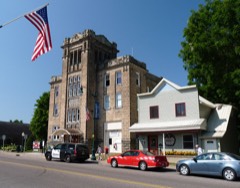 | Colfax Municipal Building | building | 2004 | 03001542 |
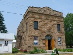 | Downsville Lodge No. 1961 I.O.O.F. | building | 2017 | 100000517 |
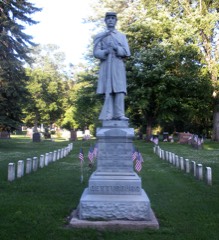 | Evergreen Cemetery | site | 2006 | 06001117 |
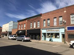 | Menomonie Downtown Historic District | district | 1986 | 86001667 |
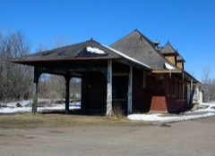 | Menomonie Omaha Depot | building | 2018 | 100002856 |
 | Louis Smith Tainter House | building | 1974 | 74000082 |
 | Mabel Tainter Memorial Building | building | 1974 | 74000083 |
Every wildfire the federal occurrence database records inside this county: 90 of them, burning about 643 acres. None started naturally and 11 were recorded as arson. Each settlement page carries the fires within five miles of it.
| Reported cause | Fires |
|---|---|
| Missing data/not specified/undetermined | 33 |
| Debris and open burning | 31 |
| Arson/incendiarism | 11 |
| Equipment and vehicle use | 7 |
| Smoking | 3 |
| Misuse of fire by a minor | 2 |
| Recreation and ceremony | 2 |
| Fireworks | 1 |
The five largest, by the area the report gives. One of them was set deliberately.
| Date | Cause | Size | Reported by | Name on the report |
|---|---|---|---|---|
| 6 April 2009 | Fireworks | 390 acres | Wisconsin Department of Natural Resources | MUDDY CREEK WILDLIFE AREA |
| 24 March 2003 | Debris and open burning | 148 acres | Wisconsin Department of Natural Resources | not named |
| 20 May 2020 | Debris and open burning | 20 acres | Wisconsin Department of Natural Resources | 2020022 |
| 23 March 2003 | Debris and open burning | 12 acres | Wisconsin Department of Natural Resources | not named |
| 28 April 2004 | Arson/incendiarism | 7.0 acres | Wisconsin Department of Natural Resources | not named |
| 24 April 2018 | Debris and open burning | 6.0 acres | Wisconsin Department of Natural Resources | 18016 |
| 25 April 2018 | Missing data/not specified/undetermined | 5.0 acres | Wisconsin Department of Natural Resources | 861 |
| 30 April 2020 | Misuse of fire by a minor | 5.0 acres | Wisconsin Department of Natural Resources | 2020018 |
Every settlement page carries the fires within five miles of it - see the settlement index below.
The NOAA Storm Events Database holds 353 reports for this county, causing 23 deaths, 85 injuries and about $64,891,000 in recorded property damage. Each settlement page carries the reports that name it.
| Kind of event | Reports |
|---|---|
| Thunderstorm Wind | 167 |
| Hail | 132 |
| Tornado | 24 |
| Flash Flood | 15 |
| Funnel Cloud | 8 |
| Lightning | 4 |
| Heavy Rain | 2 |
| Flood | 1 |
The most serious of them, by death, then injury, then recorded damage. The accounts are quoted exactly as the forecast office filed them.
| When | Event | Place named | Harm | What the report says |
|---|---|---|---|---|
| June 1958 | Tornado (F5) | not stated | 20 killed, 54 hurt, $25,000,000 | no account filed |
| July 1980 | Tornado (F2) | not stated | 1 killed, 12 hurt, $2,500,000 | no account filed |
| August 2021 | Lightning | Menomonie | 1 killed, 1 hurt | Lightning struck two construction workers. One died and the other was transported to a local hospital with serious injuries. |
| May 2012 | Thunderstorm Wind | Boyceville | 1 killed | Local law enforcement officials indicated that a large tree limb broke off and fell on an individual and caused a fatality. |
| May 1998 | Tornado (F2) | Menomonie | 8 hurt, $400,000 | Two people severely injured during house collapse. Two homes destroyed. Several barns and sheds were also demolished. 6 people suffered minor injuries. One mobile home destroyed. |
| June 1990 | Thunderstorm Wind | not stated | 3 hurt | no account filed |
| May 1998 | Thunderstorm Wind | Menomonie | 2 hurt, $300,000 | Trailer home destroyed. Damage estimate for entire county. |
| May 1998 | Thunderstorm Wind | Elk Mound | 2 hurt | Mobile home blown 50 feet, injuring 2. Estimated windspeed. |
| May 1998 | Tornado (F1) | Meridean | 1 hurt, $1,900,000 | Chemical fertilizer plant northwest of Elk Mound sustained most of the severe damage. One house and a mobile home near Elk Mound were also destroyed. 7 other homes damaged. One man injured by flying glass. |
| September 1951 | Tornado (F3) | not stated | 1 hurt, $250,000 | no account filed |
| September 1971 | Tornado (F2) | not stated | 1 hurt, $25,000 | no account filed |
| June 1958 | Tornado (F5) | not stated | $25,000,000 | no account filed |
| September 1982 | Tornado (F2) | not stated | $2,500,000 | no account filed |
| May 1996 | Thunderstorm Wind | Connorsville | $2,200,000 | no account filed |
| June 2014 | Tornado (EF1) | Rusk | $1,200,000 | A storm survey indicated that most of the damage was rated EF-0 with winds up to 85 mph. However, the tornado did briefly strengthen to EF-1 on the northeast side of Colfax, at the local high school where a shed was destroyed and two HVAC units where blown off the roof. This is where the winds may have reached 90 mph. The tornado was often less than 25 yards wide but it did widen to a maximum of 100 yards at the local high school athletic field. |
| June 2001 | Thunderstorm Wind | Eau Galle | $500,000 | Numerous trees down with some roof damage. Sheds and barns down. |
| April 1994 | Tornado (F1) | Ridgeland to | $500,000 | no account filed |
| September 2019 | Tornado (EF0) | Elk Mound | $250,000 | A NWS Storm Survey determined a tornado began on the south side of Elk Mound, near the intersection of I-94, and South Holly Road. The tornado moved northeast, crossing I-94, and continued into Chippewa County as it crossed 10th Street, south of 560th Avenue. Most of the damage was EF0 in Dunn County where a barn lost its roof, and trees were uprooted or blown down. The path length in Dunn County was 2.3 miles long, with a maximum width of 250 yards. |
| August 2009 | Flash Flood | Eau Galle | $250,000 | A team of NWS employees and local law enforcement officials surveyed a large area of road damage caused by flash flooding. The survey revealed that county roads along the Missouri and Little Missouri Creek northwest of Eau Galle, Wisconsin, had signs of flood damage and mud slides. Several roads were washed out near Eau Galle, Wisconsin. Also, local law enforcement officials reported a mudslide east of Downsville, Wisconsin along County Road C. |
| June 2002 | Thunderstorm Wind | Menomonie | $250,000 | Numerous trees down, some on homes, outbuildings and sheds. |
| July 1971 | Tornado (F2) | not stated | $250,000 | no account filed |
| July 2016 | Thunderstorm Wind | Connorsville | $200,000 | Local law enforcement officials and the emergency management survey an area of damage between Graytown, and eastward to County Road V along 1410th Street. There were numerous trees blown down, and structural damage to local residences including farm equipment. |
| May 2008 | Tornado (EF0) | Graytown | $200,000 | Numerous trees were toppled, along with damage to a few barns, silos, and outbuildings. |
| June 1997 | Tornado (F2) | Downsville | $200,000 | Three silos, machine shed, barn and several trees damaged or destroyed. Pieces of shed found 1 mile away. Numerous trees and power lines down. |
| July 2016 | Thunderstorm Wind | Eau Galle | $100,000 | Minor damage occurred in the southwest corner of Dunn County. The area most affected was Eau Galle township, south of County Road P, to the county line. High winds blew down a cattle barn at N739 County Road D in Eau Galle. |
| May 2001 | Hail | Menomonie | $100,000 | Numerous cars damaged. |
| June 2001 | Lightning | Menomonie | $83,000 | Lightning struck a barn and set it on fire. |
| August 2009 | Lightning | Menomonie | $65,000 | Lightning struck a pine tree which fell on a home in Memomonie, Wisconsin and caused a house fire. |
| July 2021 | Thunderstorm Wind | Weston | $50,000 | This is the continuation of the minor damage across Dunn County. This area was more concentrated in southwest Dunn County between Weston and Eau Galle. |
| July 2010 | Thunderstorm Wind | Hatchville | $50,000 | Straight-line winds caused considerable damage from near the Pierce/Dunn County line, eastward to the city of Menomonie, including numerous uprooted trees and power lines blown down. |
| August 2009 | Thunderstorm Wind | Red Cedar | $50,000 | A storm survey determined that straight-line winds caused numerous trees to be blown down or uprooted, along with a large trailer flipped over. The damaged area is approximately two miles long and 1/2 mile wide from near the intersection of State Road 85 and 690th Street, north-northeast to near 90th Street. |
| April 2002 | Thunderstorm Wind | Menomonie | $50,000 | Narrow swath of wind damage. Roof off barn. Old, abandoned wooden one-room schoolhouse collapsed. Several outbuildings down. Downburst wind per NWS damage survey. |
| August 1995 | Thunderstorm Wind | Sand Creek | $50,000 | Roof damage to two barns. Trees down across Sand Creek, Wilson, Grant and Otter Creek townships. |
| August 2001 | Flash Flood | Countywide | $50,000 | no account filed |
| August 1995 | Thunderstorm Wind | Sand Creek | $50,000 | no account filed |
| April 1994 | Thunderstorm Wind | Downing | $50,000 | no account filed |
| May 1994 | Thunderstorm Wind | Menomonie | $50,000 | no account filed |
| July 2005 | Lightning | Menomonie | $30,000 | The chimney of a vacant home on county highway Y was struck by lightning. The resulting fire caused $30,000 damage to the structure. |
| June 2021 | Thunderstorm Wind | Menomonie | $25,000 | Scattered trees and power lines were blown down near and south of Menomonie. One of the trees damaged an apartment building near a high school. |
| July 2021 | Thunderstorm Wind | Connorsville | $25,000 | Dunn County had reports of scattered minor damage across the county. There were a few areas that had more power outages related to downed trees and power lines. One area in the northwest portion of the county was between Connorsville and Boyceville. |
| September 1982 | Tornado (F1) | not stated | $25,000 | no account filed |
| April 1970 | Tornado (F1) | not stated | $25,000 | no account filed |
| June 1997 | Tornado (F1) | Menomonie | $22,000 | Shed destroyed. Corn stalks driven into the seams of house siding. |
| May 2016 | Thunderstorm Wind | Elk Mound | $15,000 | A 14 foot barn wall was blown off with roof damage to the adjacent house. There were also numerous trees, up to 2.5 feet in diameter, that were blown down in Elk Mound. |
| July 2015 | Tornado (EF1) | Eau Galle | $10,000 | A storm survey indicated an EF-1 occurred near Eau Galle, Wisconsin. The EF-1 tornado formed one mile northwest of Eau Galle, and continued generally east to four miles east of Eau Galle. Most of the damage was down trees and power lines. The greatest damage occurred just north of Eau Galle, where trees were snapped and uprooted, and a home weather station reported a maximum wind gust of 88 mph. The maximum width was 50 yards and was on the ground for approximately 5.3 miles. |
| May 2012 | Thunderstorm Wind | Rock Falls | $10,000 | Several trees down, including some on a trailer and a garage. |
| July 2011 | Thunderstorm Wind | Cedar Falls | $10,000 | An 8 inch diameter tree was toppled along with some power lines blown down. |
| May 2022 | Thunderstorm Wind | Eau Galle | $5,000 | A metal shed was blown down near Eau Galle. |
| June 2005 | Flash Flood | Countywide | $5,000 | Water rushed over Highway 64 just east of County Road M about 2 miles south southeast of Sand Creek. After the water receded the road was covered in mud. In addition, County Road M was flooded north of Highway 64. Nearby fields were also flooded. |
| June 2021 | Thunderstorm Wind | Knapp | $3,000 | Several large trees were blown down near Knapp. |
| June 2015 | Tornado (EF0) | Boyceville | $2,000 | A tornado knocked down about a dozen trees before entering a farm, where there was minor damage to eaves and soffits of the main building as well as to some outdoor furnishings. Winds were estimated at about 65 mph. The tornado was caught on video by a local storm chaser. |
| July 2011 | Thunderstorm Wind | Boyceville | $2,000 | A pickup truck hauling several canoes rolled over on Highway 170 due to severe straight line winds. In addition, several trees were blown down in the area. |
| July 2010 | Thunderstorm Wind | Downing | $2,000 | Dozens of large trees were toppled from Downing to Boyceville. Some power lines were also downed. |
| July 2010 | Thunderstorm Wind | Boyceville | $2,000 | A power line was blown down in the city of Boyceville, Wisconsin. |
| May 2025 | Thunderstorm Wind | Colfax | - | A storm survey determined a downburst produced damage along a 4 mile long path, with a swath that broadened out to two miles wide. Winds were estimated at 75 to 85 mph. Many dozens of trees were toppled or broken. Part of a barn roof was blown off and another barn was shifted off its foundation. Two homes had some shingles blown off along with damaged fascia and gutters. A flagpole rated for 80 mph was snapped. |
| May 2025 | Hail | Elk Mound | - | Quarter sized hail report via MPING near Elk Mound. |
| July 2025 | Thunderstorm Wind | Menomonie | - | Report of power lines and trees down in Menomonie. |
| July 2025 | Thunderstorm Wind | Downsville | - | Multiple large oak trees snapped and uprooted southeast of Downsville. |
| July 2025 | Thunderstorm Wind | Eau Galle | - | Thunderstorm winds estimated at 75 mph uprooted several trees and broke a flagpole in Eau Galle. |
| July 2025 | Thunderstorm Wind | Menomonie | - | Multiple power lines and trees downed near Menomonie. Some minor roof damage was reported as well. |
The Survey's mineral resources record lists 135 workings inside this county. 8 still produce and 127 are closed or unrecorded. Each settlement page carries the workings within five miles of it.
| Commodity | Workings |
|---|---|
| Sand and Gravel, Construction | 71 |
| Stone, Crushed/Broken | 58 |
| Clay | 3 |
| Stone | 2 |
| Sand and Gravel, Industrial/Frac Sand | 1 |
The least common of them first, because a county's hundredth gravel pit says nothing its first ten did not.
| Where | Site | Commodity | Status | Recorded |
|---|---|---|---|---|
| Menomonie Mine | Sand and Gravel, Industrial/Frac Sand | Producer | ||
| Own Crews | Stone | Unknown | ||
| Sherman Quarry | Stone | Unknown | ||
| Hay River Clay Deposit | Clay | Occurrence | ||
| Lambs Creek Clay Deposit | Clay | Occurrence | ||
| Wheeler Clay Pit | Clay | Past Producer | ||
| Arles Hoff Dolomite Deposit | Stone, Crushed/Broken | Occurrence | ||
| Barron County Ag Dept. | Stone, Crushed/Broken | Producer | ||
| Bates Quarry | Stone, Crushed/Broken | Past Producer | ||
| Big Beaver Creek Sandstone Deposit | Stone, Crushed/Broken | Occurrence | ||
| Big Beaver Creek Sandstone Quarry | Stone, Crushed/Broken | Past Producer | ||
| Bolen Creek Dolomite Deposit | Stone, Crushed/Broken | Occurrence | ||
| Bundy Pit | Stone, Crushed/Broken | Past Producer | ||
| Butler Shale Quarry | Stone, Crushed/Broken | Past Producer | ||
| C. Mittlestadt Sandstone Quarry | Stone, Crushed/Broken | Past Producer | ||
| Caryville Sandstone Quarry | Stone, Crushed/Broken | Past Producer | ||
| Colfax Sandstone Quarry | Stone, Crushed/Broken | Past Producer | ||
| Connorsville Sandstone Deposit | Stone, Crushed/Broken | Occurrence | ||
| Connorsville Sandstone Quarry | Stone, Crushed/Broken | Past Producer | ||
| Downing Sandstone Deposit #1 | Stone, Crushed/Broken | Occurrence | ||
| Downing Sandstone Deposit #2 | Stone, Crushed/Broken | Occurrence | ||
| Downing Sandstone Deposit #3 | Stone, Crushed/Broken | Occurrence | ||
| Dunn County Highway Dept. | Stone, Crushed/Broken | Past Producer | ||
| E. & D. Keller Sandstone Deposit | Stone, Crushed/Broken | Occurrence | ||
| Eau Galle River Dolomite Deposit #2 | Stone, Crushed/Broken | Occurrence | ||
| Falkner Shale Quarry | Stone, Crushed/Broken | Past Producer | ||
| Fesenmaier Dolomite Quarry | Stone, Crushed/Broken | Past Producer | ||
| Gilbert Creek Dolomite Deposit #1 | Stone, Crushed/Broken | Occurrence | ||
| Gilbert Creek Dolomite Deposit #2 | Stone, Crushed/Broken | Occurrence | ||
| Gilbert Creek Dolomite Deposit #3 | Stone, Crushed/Broken | Occurrence | ||
| Gilbert Creek Dolomite Deposit #4 | Stone, Crushed/Broken | Occurrence | ||
| Gilbert Creek Dolomite Deposit #5 | Stone, Crushed/Broken | Occurrence | ||
| Gilbert Creek Dolomite Quarry | Stone, Crushed/Broken | Past Producer | ||
| Gilbert Creek Sandstone Quarry | Stone, Crushed/Broken | Past Producer | ||
| Ginsbach Dolomite Deposit | Stone, Crushed/Broken | Occurrence | ||
| Grant Styer Dolomite Deposit | Stone, Crushed/Broken | Occurrence | ||
| Hay Creek Dolomite Deposit #1 | Stone, Crushed/Broken | Occurrence | ||
| Hay Creek Dolomite Deposit #2 | Stone, Crushed/Broken | Occurrence | ||
| Hay Creek Shale Quarry | Stone, Crushed/Broken | Past Producer | ||
| Herman Kuehl Dolomite Quarry | Stone, Crushed/Broken | Past Producer | ||
| Irving Creek Dolomite Quarry | Stone, Crushed/Broken | Past Producer | ||
| Irvington Dolomite Deposit | Stone, Crushed/Broken | Occurrence | ||
| J. A. Samenfink Sandstone Deposit | Stone, Crushed/Broken | Occurrence | ||
| Knapp Sandstone & Shale Deposit | Stone, Crushed/Broken | Occurrence | ||
| Knights Creek Dolomite Quarry | Stone, Crushed/Broken | Past Producer | ||
| Lambs Creek Dolomite Deposit #1 | Stone, Crushed/Broken | Occurrence | ||
| Lambs Creek Dolomite Deposit #2 | Stone, Crushed/Broken | Occurrence | ||
| Little Elk Creek Shale Quarry | Stone, Crushed/Broken | Past Producer | ||
| Little Otter Creek Shale Quarry | Stone, Crushed/Broken | Past Producer | ||
| Little Otter Creek Siltstone Quarry | Stone, Crushed/Broken | Past Producer | ||
| Markham Shale Quarry | Stone, Crushed/Broken | Past Producer | ||
| Otter Creek Shale Quarry | Stone, Crushed/Broken | Past Producer | ||
| Popple Creek Siltstone Deposit | Stone, Crushed/Broken | Occurrence | ||
| Red Cedar River Limestone Deposit | Stone, Crushed/Broken | Occurrence | ||
| Ridgeland Sandstone Deposit | Stone, Crushed/Broken | Occurrence | ||
| Robert Stewart Dolomite Deposit | Stone, Crushed/Broken | Occurrence | ||
| Rock Creek Shale Quarry | Stone, Crushed/Broken | Past Producer | ||
| Rush Creek Sandstone Deposit | Stone, Crushed/Broken | Occurrence | ||
| Schlosser Quarry | Stone, Crushed/Broken | Past Producer | ||
| Styer Dolomite Deposit | Stone, Crushed/Broken | Occurrence | ||
| Township of Red Cedar Quarry | Stone, Crushed/Broken | Past Producer | ||
| Vivoda Dolomite Quarry | Stone, Crushed/Broken | Past Producer | ||
| West Road Sandstone Deposit | Stone, Crushed/Broken | Occurrence | ||
| Wilson Creek Sandstone Quarry | Stone, Crushed/Broken | Past Producer | ||
| Albricht Pit | Sand and Gravel, Construction | Producer | ||
| Amundson Pit | Sand and Gravel, Construction | Past Producer | ||
| Annis Creek Gravel Pit | Sand and Gravel, Construction | Past Producer | ||
| Caryville Gravel Deposit | Sand and Gravel, Construction | Occurrence | ||
| Caryville Gravel Pit | Sand and Gravel, Construction | Past Producer | ||
| Caryville Sand Deposit | Sand and Gravel, Construction | Occurrence | ||
| Cedar Falls Gravel Pit | Sand and Gravel, Construction | Past Producer | ||
| Chippewa River Gravel Deposit #1 | Sand and Gravel, Construction | Occurrence | ||
| Colfax Gravel Deposit | Sand and Gravel, Construction | Occurrence | ||
| Colfax Gravel Pit | Sand and Gravel, Construction | Past Producer | ||
| Connorsville Gravel Pit | Sand and Gravel, Construction | Past Producer | ||
| Connorsville Sand Deposit | Sand and Gravel, Construction | Occurrence | ||
| Coon Creek Gravel Pit | Sand and Gravel, Construction | Past Producer | ||
| Coon Creek Sand Deposit | Sand and Gravel, Construction | Occurrence | ||
| Downing Gravel Pit | Sand and Gravel, Construction | Past Producer | ||
| Downsville Gravel Pit | Sand and Gravel, Construction | Past Producer | ||
| Dunn Cnty Hwy Dept. Pit | Sand and Gravel, Construction | Producer | ||
| Dunnville Gravel Pit | Sand and Gravel, Construction | Past Producer | ||
| Elk Creek Gravel Deposit #1 | Sand and Gravel, Construction | Occurrence | ||
| Elk Creek Gravel Pit #1 | Sand and Gravel, Construction | Past Producer | ||
| Elk Creek Gravel Pit #2 | Sand and Gravel, Construction | Past Producer | ||
| Elk Creek Sand Deposit #1 | Sand and Gravel, Construction | Occurrence | ||
| Elk Creek Sand Deposit #2 | Sand and Gravel, Construction | Occurrence | ||
| Elk Mound Gravel Deposit | Sand and Gravel, Construction | Occurrence | ||
| Elk Mound Gravel Pit | Sand and Gravel, Construction | Past Producer | ||
| Elton Talford Gravel Pit | Sand and Gravel, Construction | Past Producer | ||
| Ferry Pit | Sand and Gravel, Construction | Producer | ||
| Fry Sand Deposit | Sand and Gravel, Construction | Occurrence | ||
| Gilbert Creek Gravel Pit | Sand and Gravel, Construction | Past Producer | ||
| Hagberg Pit | Sand and Gravel, Construction | Producer | ||
| Hay River Gravel Deposit #1 | Sand and Gravel, Construction | Prospect | ||
| Hay River Gravel Deposit #2 | Sand and Gravel, Construction | Prospect | ||
| Hay River Gravel Pit #1 | Sand and Gravel, Construction | Past Producer | ||
| Hay River Gravel Pit #2 | Sand and Gravel, Construction | Past Producer | ||
| Hay River Gravel Pit #3 | Sand and Gravel, Construction | Past Producer | ||
| Hay River Gravel Pit #4 | Sand and Gravel, Construction | Past Producer | ||
| Hay River Gravel Pit #5 | Sand and Gravel, Construction | Past Producer | ||
| Hay River Gravel Pit #6 | Sand and Gravel, Construction | Past Producer | ||
| Lake Menomin Gravel Deposit | Sand and Gravel, Construction | Occurrence | ||
| Lake Menomin Gravel Pit | Sand and Gravel, Construction | Past Producer | ||
| Lightfoot Gravel Deposit | Sand and Gravel, Construction | Occurrence | ||
| Little Elk Creek Gravel Deposit | Sand and Gravel, Construction | Prospect | ||
| Lower Pine Creek Gravel Pit | Sand and Gravel, Construction | Past Producer | ||
| Lucas Sand Pit | Sand and Gravel, Construction | Past Producer | ||
| Menomonie Gravel Deposit | Sand and Gravel, Construction | Occurrence | ||
| Menomonie Gravel Pit | Sand and Gravel, Construction | Past Producer | ||
| Menomonie Junction Sand Deposit | Sand and Gravel, Construction | Past Producer | ||
| Muddy Creek Gravel Pit #1 | Sand and Gravel, Construction | Past Producer | ||
| Pit 57 | Sand and Gravel, Construction | Producer | ||
| Red Cedar Pit | Sand and Gravel, Construction | Past Producer | ||
| Red Cedar River Gravel Deposit #1 | Sand and Gravel, Construction | Occurrence | ||
| Red Cedar River Gravel Deposit #2 | Sand and Gravel, Construction | Occurrence | ||
| Red Cedar River Gravel Pit #1 | Sand and Gravel, Construction | Past Producer | ||
| Red Cedar River Gravel Pit #2 | Sand and Gravel, Construction | Past Producer | ||
| Red Cedar River Gravel Pit #3 | Sand and Gravel, Construction | Past Producer | ||
| Red Cedar River Gravel Pit #4 | Sand and Gravel, Construction | Past Producer | ||
| Ridgeland Gravel Deposit | Sand and Gravel, Construction | Occurrence | ||
| Ridgeland Sand Pit | Sand and Gravel, Construction | Past Producer | ||
| Robert Sol Sand Deposit | Sand and Gravel, Construction | Occurrence | ||
| Robert Talford Gravel Pit | Sand and Gravel, Construction | Past Producer | ||
| Running Valley Creek Gravel Pit | Sand and Gravel, Construction | Past Producer | ||
| Sand Creek Gravel Deposit | Sand and Gravel, Construction | Occurrence | ||
| Sand Creek Gravel Pit | Sand and Gravel, Construction | Past Producer | ||
| Tainter Lake Gravel Deposit | Sand and Gravel, Construction | Occurrence | ||
| Tiffany Creek Gravel Pit | Sand and Gravel, Construction | Past Producer | ||
| Townline Road Gravel Pit | Sand and Gravel, Construction | Past Producer | ||
| Washburn Farm Creek Gravel Deposit | Sand and Gravel, Construction | Occurrence | ||
| Wheeler Sand Deposit | Sand and Gravel, Construction | Occurrence | ||
| Wilson Creek Gravel Pit #1 | Sand and Gravel, Construction | Past Producer | ||
| Wilson Creek Gravel Pit #2 | Sand and Gravel, Construction | Past Producer | ||
| Wolf Pit | Sand and Gravel, Construction | Producer |
Named settlements recorded in the Geographic Names Information System, each with the topographic sheets covering it. Villages, hamlets and abandoned places alike. Each is shown with the nearest named watercourse or landform and the survey quadrangle it falls on.
Rock Creek town · 54701 · On Coon Creek · Elk Creek Lake quadrangle
13 sheets, 1934 to 1985
Colfax village · 54730 · On Eighteenmile Creek · Colfax South quadrangle
13 sheets, 1934 to 1985
New Haven town · 54734 · On Flayton Creek · Connorsville quadrangle
12 sheets, 1948 to 1985
Elk Mound village · 54739 · On Elk Mound · Elk Creek Lake quadrangle
13 sheets, 1934 to 1985
Menomonie town · 54751 · On Irving Creek · Menomonie South quadrangle
13 sheets, 1940 to 1985
Knapp village · 54749 · On North Branch Wilson Creek · Knapp quadrangle
11 sheets, 1946 to 1990
Menomonie city · 54751 · On Wilson Creek · Menomonie North quadrangle
12 sheets, 1940 to 1985
Menomonie city · 54751 · On Wilson Creek · Menomonie North quadrangle
12 sheets, 1940 to 1985
Peru town · 54751 · On Cranberry Creek · Meridean quadrangle
12 sheets, 1929 to 1985
No longer a settlement
Eau Galle town · 54737 · On Hay Creek · Arkansaw quadrangle
13 sheets, 1935 to 1990
No longer a settlement
Weston town · 54751 · On West Branch Knights Creek · Weston quadrangle
11 sheets, 1946 to 1990
The vanished settlements of Dunn County: the places named above that are no longer on the map.