 Block
Turtleville, Wisconsin
18 topographic sheets cover this place, the earliest surveyed in 1893 and the latest in 1980. It stands in Turtle town. It lies in ZIP code area 53511. The Survey maps it on the Shopiere quadrangle.
On record in Turtleville
Buildings and businesses the archive holds for this place. Each opens its own page, with the source record it came from.
On the National Register within a mile 1 record
The National Register names another town for these. They stand within one mile of this settlement's coordinate.
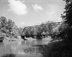 Turtleville Iron Bridgelisted 1977 · 0.3 miles away
Topographic sheets covering this place
8 surveys from 18 printed sheetsMatched by testing this settlement's coordinate against the published boundary of every sheet in the United States Geological Survey's historical collection. Each opens the scanned sheet at the Survey.
- 1893 USGS Shopiere quadrangle1:62500, 5 printings
- 1954 USGS Rockford quadrangle1:250000
- 1955 USGS Rockford quadrangle1:250000
- 1958 USGS Rockford quadrangle1:250000, 4 printings
- 1961 USGS Shopiere quadrangle1:24000, 3 printings
- 1961 USGS Shopiere quadrangle1:62500, 2 printings
- 1963 USGS Rockford quadrangle1:250000
- 1980 USGS Lake Geneva quadrangle1:100000





In the county-history sources
3,867 words on this townshipHistory of Rock County, and Transactions of the Rock County Agricultural Society and Mechanics' Institute, published 1856 names this settlement in its chapter on Turtle Town. These are the passages that mention it, exactly as the scans read.
Is a beautiful village in this town on Section 3. It is 9 miles South-east from Janesville, on Turtle jCreek, which gives.a water-power here of 9 feet head and fall, and is'. a very reliable' stream for supply of water. Here is a stone flouring mil), 4 stories high, running three pairs of burrs, and is completely finished throughout; cost $18,000i and built and owned by Hon, L. P. Harv6y and J. H. Randall. This mill grinds SOiOOO btishels of grain annually. A saw mill af this place, also, owned by the same; cuts annually'! 50,000 feet of oak lumber ; cdst $'2,000. Turtleville flouring mill is one mile below on the same stream. North of this village stretches Rock Prairie. South an extensive tract of timbered land, extending 7 miles. Abundance of excellent lime Stone is found in this vicinity, from whict the village' receives its name - a corruption of the French Chaux, (Sho,) signifying lime - pierre, signifying stone. Lime is made here of very expellerit quality. The Chicago, St. Pauls aud Fond du Lac Railroad passes through this place, crossing the Turtle on a fine, substantial bridge constructed by Hon. L. P. Harvey. The first settlers of this village were Caleb E. Culver, John Hopkins, J. H. Randall, A. W. Allyn, James Chamberlain and John Spencer. At aa early day, while Wis. was in its transition state from savage to civilized life, a distillery was established here, but wa.s discontinued after a few years, through the exertions and sacrifice of John Hopkins, Esq. ; to his credit be it said.
Passage source: History of Rock County, and Transactions of the Rock County Agricultural Society and Mechanics' Institute, published 1856.
About the same time, A. F. Lewis commenced another village, about one mile below on the same stream. Built a saw mill and opened a store; the first one within the present limits of Turtle. These were ever rival towns, and much strife existed between them : Turtleville claiming all the religion and morality; - Waterloo possessing all the whisky, drunkenness and swearings At a meeting of thirty citizens, to agree upon a name for the town, preparatory to an act of incorporation j and separate organization from Beloit, 29 voted for Waterloo* and only one, - B. E. Mack; - voted for the name of Turtle. When the matter went to the Legislature it was found that there was already one town in the State by that name, (Waterloo,) so it was incorporated by its present name. Such are a few early reminiscences of the early times in the history of this town. I am, &c.,
Passage source: History of Rock County, and Transactions of the Rock County Agricultural Society and Mechanics' Institute, published 1856.
Machine-read from a century-old scan, so expect the errors a machine makes: misspelled names, dropped words, stray characters.
Read the whole chapter on Turtle Town - it names this place 1 more 1 time.
Fires near this place
21 since 2018Regional context, not property-specific evidence. The federal wildfire occurrence database lists 21 fires within 5 miles of Turtleville between 2018 and 2020, burning about 66 acres in total. None started naturally. 1 was recorded as arson. Distance is straight-line from the map coordinates, so a fire counted here may appear on a neighbouring settlement's page as well.
| Reported cause | Fires |
|---|---|
| Missing data/not specified/undetermined | 10 |
| Debris and open burning | 4 |
| Recreation and ceremony | 3 |
| Smoking | 2 |
| Equipment and vehicle use | 1 |
| Arson/incendiarism | 1 |
The most recent of them, most recent first, with the day each was reported and the service that recorded it.
| Date | Cause | Size | Reported by | Name on the report |
|---|---|---|---|---|
| 25 September 2018 | Missing data/not specified/undetermined | under an acre | Wisconsin Department of Natural Resources | 181293 |
| 22 August 2019 | Debris and open burning | under an acre | Wisconsin Department of Natural Resources | 19941 |
| 30 July 2018 | Missing data/not specified/undetermined | under an acre | Wisconsin Department of Natural Resources | 181021 |
| 18 July 2019 | Arson/incendiarism | under an acre | Wisconsin Department of Natural Resources | 2019-16 |
| 22 June 2019 | Debris and open burning | under an acre | Wisconsin Department of Natural Resources | 2019137 |
| 18 June 2020 | Missing data/not specified/undetermined | under an acre | Wisconsin Department of Natural Resources | 2020-11 |
| 22 May 2018 | Missing data/not specified/undetermined | under an acre | Wisconsin Department of Natural Resources | 1800001 |
| 2 May 2018 | Smoking | under an acre | Wisconsin Department of Natural Resources | 181786 |
Settlements close enough to share some of these fires:
Mines and quarries near this place
10 within 5 milesRegional context, not property-specific evidence. The federal mineral resources record lists 10 workings within 5 miles of Turtleville: 7 producers, 3 past producers. 7 still produce. What was taken out: Sand and Gravel, Construction, Stone, Crushed/Broken. Distance is straight-line from the map coordinates, so a quarry counted here may appear on a neighbouring settlement's page as well.
| Where | Site | Commodity | Status | Recorded |
|---|---|---|---|---|
| Bjoin Quarry | Stone, Crushed/Broken | Producer | ||
| Boutelle Quarry | Stone, Crushed/Broken | Producer | ||
| Dunn Quarry | Stone, Crushed/Broken | Producer | ||
| Lathers Pit | Sand and Gravel, Construction | Producer | ||
| Poff Pit | Sand and Gravel, Construction | Past Producer | ||
| Rye Pit | Sand and Gravel, Construction | Producer | ||
| Rye Pit | Sand and Gravel, Construction | Past Producer | ||
| Skunk Hollow Pit Number 2 | Sand and Gravel, Construction | Past Producer | ||
| Townline Pit | Sand and Gravel, Construction | Producer | ||
| Turtle Township Pit | Sand and Gravel, Construction | Producer |
Nearest settlements
The eight closest, with where each one stands in the county. Distances are straight-line, computed from the Geographic Names Information System coordinates.
| Map | Place | Distance | Sheets |
|---|---|---|---|
| Shopiere | 1.3 miles | 18 | |
| Tiffany | 2.1 miles | 18 | |
| Porters | 2.9 miles | 18 | |
| Garden Village | 3.7 miles | 16 | |
| Holiday Hills | 3.9 miles | 16 | |
| Crestview | 4.1 miles | 16 | |
| Foxhollow | 4.8 miles | 18 | |
| Clinton | 5.3 miles | 16 |
Provenance
This settlement is recorded in the Geographic Names Information System as feature 2760397. The sheet list is computed by point-in-boundary test against the United States Geological Survey's historical topographic inventory. Both are works of the United States government and carry no copyright under 17 U.S.C. 105.
Wildfire. Short, Karen C. 2022. Spatial wildfire occurrence data for the United States, 1992-2020 [FPA_FOD_20221014]. 6th Edition. Fort Collins, CO: Forest Service Research Data Archive. https://doi.org/10.2737/RDS-2013-0009.6 Collected with United States Government funding and usable without additional permissions or fees.
Mines and quarries. USGS Mineral Resources Data System (MRDS) https://mrdata.usgs.gov/mrds/ A work of the United States government, no copyright under 17 U.S.C. 105.