
BlockBefore
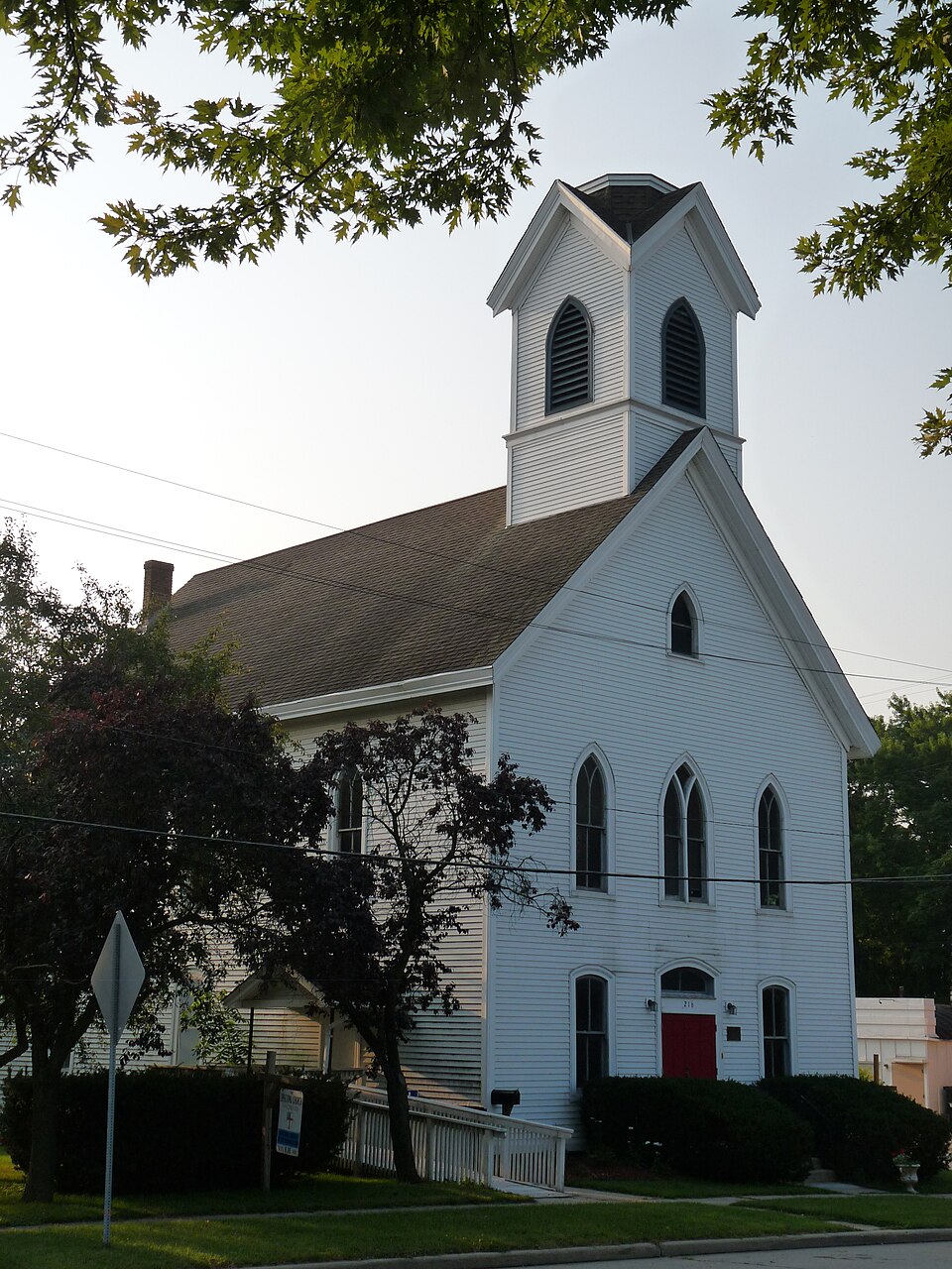
Photograph of United Unitarian and Universalist Church
Photograph by Jeff the quiet, CC0 1.0. Via Wikimedia Commons.

United Unitarian and Universalist Church

Built in 1879 (Gothic Revival). Listed on the National Register of Historic Places in 1987.

From the record

“The United Unitarian and Universalist Church in Mukwonago, Wisconsin is a Victorian Gothic-styled church and meeting hall built in 1878 - the only Yankee-built church remaining in the town. In 1987 it was added to the National Register of Historic Places for its significance in architecture and social history.”

Wikipedia article United Unitarian and Universalist Church, CC BY-SA 4.0.

One of 153 National Register listings published here for Waukesha County · listed in 1987 · category: Building · built in 1879, Gothic Revival.

Sources: the Wikipedia article · the case file at the National Archives · the National Register database, National Park Service
The listing

  • What is counted as historic. The nomination lists 1 building as contributing to the listing.
  • Address. 216 Main St., Mukwonago, 53149
  • When was it listed? October 1987
  • Category. building
  • Village. Mukwonago village
  • When was it built? 1879
  • Architectural style. Gothic Revival
  • National Register reference number. 87001759 - the number the National Park Service assigned this property when it was listed, and the key its nomination file is catalogued under at the National Archives.

Fires near this property

14 since 2008

Regional context, not property-specific evidence. The federal wildfire occurrence database lists 14 fires within 5 miles of United Unitarian and Universalist Church between 2008 and 2020, burning about 71 acres in total. None started naturally. 3 were recorded as arson. Distance is straight-line from the map coordinates, so a fire counted here may appear on a neighbouring settlement's page as well.

Reported cause Fires
Missing data/not specified/undetermined7
Debris and open burning3
Arson/incendiarism3
Recreation and ceremony1

The most recent of them, most recent first, with the day each was reported and the service that recorded it.

DateCause SizeReported by Name on the report
26 July 2018Missing data/not specified/undeterminedunder an acreWisconsin Department of Natural Resources73
23 June 2018Missing data/not specified/undetermined1.0 acresWisconsin Department of Natural Resources312
8 May 2018Debris and open burningunder an acreWisconsin Department of Natural Resources233
7 May 2018Missing data/not specified/undeterminedunder an acreWisconsin Department of Natural Resources18092
30 May 2019Arson/incendiarism1.0 acresWisconsin Department of Natural Resources19128
3 May 2020Missing data/not specified/undetermined15 acresWisconsin Department of Natural Resources20089
5 April 2020Recreation and ceremony10 acresWisconsin Department of Natural Resources163
23 April 2008Arson/incendiarism38 acresWisconsin Department of Natural Resourcesnot named

Every fire recorded in Waukesha County

Mines and quarries near this property

2 within 5 miles

Regional context, not property-specific evidence. The federal mineral resources record lists 2 workings within 5 miles of United Unitarian and Universalist Church: 1 occurrence, 1 producer. 1 still produces. What was taken out: Sand and Gravel, Construction. Distance is straight-line from the map coordinates, so a quarry counted here may appear on a neighbouring settlement's page as well.

Where SiteCommodity StatusRecorded
Army Lake Sand DepositSand and Gravel, ConstructionOccurrence
Hales Corners PitSand and Gravel, ConstructionProducer

Every working recorded in Waukesha County

Storms near this property

31 since 1996

Regional context, not property-specific evidence. The National Weather Service names Mukwonago, the town this property stands in, in 31 storm reports between 1996 and 2025: 16 hail, 9 thunderstorm wind, 3 flash flood, 1 flood. No death or injury is recorded in these reports. Each account below is quoted exactly as the forecast office filed it, from the NOAA Storm Events Database, and each date opens the federal record of that event.

WhenEvent Place namedHarm What the report says
October 1996HailMukwonago$1,200,000no account filed
August 2007Flash FloodMukwonago$100,000Flash flooding affected the Mukwanago area after heavy rains of 6.8 inches fell overnight. Water depths on some city strees reached 2 to 4 feet, and significant soil erosion was noted in the surrounding countryside. At least 25 homes sustained minor flood damage to basement contents. Gravel shoulder washouts occurred and crops in the area were damaged. To the west, a spotter at a location .6SE Eagle had 4.76 overnight.
September 2005Flash FloodMukwonago$50,000Flooded roads and some flooded basements were reported across portions of central and southern Waukesha county, damaging contents inside.
June 1999Thunderstorm WindMukwonago$40,000no account filed
August 2008LightningMukwonago$25,000Lightning struck a garage on Cherry Lane, causing a small fire in an upstairs bedroom. The contents was a total loss.
October 2013Flash FloodMukwonago$14,000Many cars disabled due to severe street flooding in the city of Waukesha. Street flooding throughout eastern Waukesha County. Several manhole covers removed from flooding. The new Health and Human Services Building in the city of Waukesha was flooded.
April 1997Thunderstorm WindMukwonago$12,000no account filed
July 2021Thunderstorm WindMukwonago$3,000Tree limbs down, transformer exploded behind Village of Mukwonago Police Department.
August 2015HailMukwonago$3,000The hail put holes in the roof of a camper and dented a truck.
May 2012Thunderstorm WindMukwonago$2,000A trained spotter reported an estimated thunderstorm wind gust of 65 mph (56 knots) two miles bnorth of Mukwonago.
July 2005Thunderstorm WindMukwonago$1,000no account filed
June 1997Thunderstorm WindMukwonago$1,000no account filed
March 2017HailMukwonago-Penny to three quarter inch diameter hail for about 10 minutes.
May 2013HailMukwonago-The public reported hail up to 1.25 inches in diameter about 1 mile southwest of Mukwonago.
June 2011Thunderstorm WindMukwonago-Part of a line of severe thunderstorms with damaging wind gusts up to 70 mph (60 knots) that blew down numerous trees moved through northeast and eastern Waukesha County during the middle afternoon of June 21st.
June 2010Thunderstorm WindMukwonago-Powerful thunderstorm wind gusts toppled several large trees.
June 2009Tornado (EF0)Mukwonago-A weak, minimal EFO tornado spun up along a line of severe thunderstorms that progressed across southern Wisconsin. The responsible supercell actually developed a mesocyclone when it crossed the Jefferson-Waukesha County line west of the village of Eagle. The tornado started at the west end of Lower Phantom Lake and tracked just north of east through the city of Mukwanago and dissipated near the intersection of the Mukwanago River and the Fox River east of the city. Damage was limited to uprooted trees and broken large limbs. The winds were estimated at 56 to 61 knots (65-70 mph). The average path width was about 30 yards. The compass bearing was about 80 degrees. Start and ending location was 42.86003/-88.36303 and 42.86666/-88.30144. DI#27(TH), DOD2.
September 2005Thunderstorm WindMukwonago-There were widespread reports of trees and powerlines toppled across Waukesha County. Law enforcement reported a measured gust of 58 knots (67 mph) around the city of Waukesha. Trained spotters estimated wind gusts of 70 to 74 knots (80 to 85 mph) embedded within the larger area of damaging winds between just south of Waukesha through Brookfield.
May 2025HailMukwonago-no account filed
April 2025HailMukwonago-no account filed
May 2024HailMukwonago-no account filed
July 2023HailMukwonago-no account filed
April 2016HailMukwonago-no account filed
August 2015HailMukwonago-no account filed
June 2009HailMukwonago-no account filed
March 2007HailMukwonago-no account filed
May 2005HailMukwonago-no account filed
November 2005HailMukwonago-no account filed
May 2000HailMukwonago-no account filed
July 2000FloodMukwonago-no account filed

Every storm recorded in Waukesha County

Map coverage status

No historic map-sheet match is published for this property yet. That does not mean no map exists. This record needs a coordinate-quality review before it can be joined to a sheet boundary. Browse the county's mapped places while that work is pending.

Listed places nearby

6 within 8 miles

Other National Register properties close enough to walk or drive between, ordered by distance from this one. Both positions come from the same geocoding pass that matched these properties to their map sheets.

Photograph PropertyDistance Listed
Sewall Andrews Houseunder 500 feet1981
Pearl and Grand Avenue Historic District0.3 miles2004
J. C. Booth House5.4 miles1973
Saylesville Historic District6.0 miles2003
Haseltine Cobblestone House6.6 miles1980
Ahira R. Hinkley House6.7 miles1974

Sources for this property

National Archives recordThe nomination case file for reference 87001759 in Record Group 79.
Wikipedia articleCommunity-written account of this property, licensed CC BY-SA.
Waukesha CountyAll 153 listed properties in this county.

Provenance

  • Listing record. National Park Service National Register of Historic Places, listed-properties dataset, current to 2026-05-22.
  • Map join. Address geocoded through the United States Census geocoder, then tested against the published boundary of every sheet in the USGS Historical Topographic Map Collection.
  • How this page is made. Listing fields come from federal records; map-sheet coverage is a labelled coordinate-to-boundary calculation, not a source-field claim.
  • Wildfire. Short, Karen C. 2022. Spatial wildfire occurrence data for the United States, 1992-2020 [FPA_FOD_20221014]. 6th Edition. Fort Collins, CO: Forest Service Research Data Archive. https://doi.org/10.2737/RDS-2013-0009.6 Collected with United States Government funding and usable without additional permissions or fees.
  • Mines and quarries. USGS Mineral Resources Data System (MRDS) https://mrdata.usgs.gov/mrds/ A work of the United States government, no copyright under 17 U.S.C. 105.
  • Storms. NOAA National Centers for Environmental Information, Storm Events Database https://www.ncei.noaa.gov/stormevents/ A work of the United States government, no copyright under 17 U.S.C. 105. Narratives are quoted verbatim from the National Weather Service report and are not edited or summarised.