BlockBefore
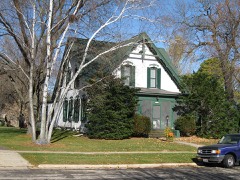
Photograph of John and Flora Gilbert House
Photograph by James Steakley, CC BY-SA 3.0. Via Wikimedia Commons.

John and Flora Gilbert House

Built in 1906 (Queen Anne style). Listed on the National Register of Historic Places in 2007.

From the record

“The John and Flora Gilbert House is a historic house located in Oregon, Wisconsin. It was added to the National Register of Historic Places on September 6, 2007.”

Wikipedia article John and Flora Gilbert House, CC BY-SA 4.0.

One of 238 National Register listings published here for Dane County · listed in 2007 · category: Building · built in 1906, Queen Anne style.

Sources: the Wikipedia article · the case file at the National Archives · the National Register database, National Park Service

The listing

  • What is counted as historic. The nomination lists 1 building as contributing to the listing.
  • Listed as. Gilbert, John and Flora, House - the National Register files a house under its owner's surname.
  • Address. 357 N. Main St., Oregon, 53575
  • When was it listed? September 2007
  • Category. building
  • Village. Oregon village
  • When was it built? 1906
  • Architectural style. Queen Anne style
  • National Register reference number. 07000933 - the number the National Park Service assigned this property when it was listed, and the key its nomination file is catalogued under at the National Archives.

The ground it stands on

13,699 words

This property stands in Oregon Village. History of Dane County, Wisconsin ... Preceded by a History of Wisconsin, Statistics of the State, and an Abstract of Its Laws and Constitution and of the Constitution of the United States, published 1880 gives that township a chapter of its own.

The chapter covers the township.

Machine-read from a century-old scan, so expect the errors a machine makes: misspelled names, dropped words, stray characters.

Read the whole chapter on Oregon Village - 13,699 words on its settlement, mills, schools and churches.

Fires near this property

12 since 2014

Regional context, not property-specific evidence. The federal wildfire occurrence database lists 12 fires within 5 miles of John and Flora Gilbert House between 2014 and 2020, burning about 12 acres in total. None started naturally. None was recorded as arson. Distance is straight-line from the map coordinates, so a fire counted here may appear on a neighbouring settlement's page as well.

Reported cause Fires
Debris and open burning4
Missing data/not specified/undetermined4
Recreation and ceremony2
Smoking2

The most recent of them, most recent first, with the day each was reported and the service that recorded it.

DateCause SizeReported by Name on the report
7 August 2018Debris and open burningunder an acreWisconsin Department of Natural Resources1289
5 April 2020Recreation and ceremonyunder an acreWisconsin Department of Natural Resources98
22 April 2018Smoking3.0 acresWisconsin Department of Natural Resources18418
18 April 2014Debris and open burning2.0 acresLeopold Wetland Management DistrictSCHULTZ WF
12 April 2020Recreation and ceremonyunder an acreWisconsin Department of Natural Resources43
11 April 2018Smoking2.0 acresWisconsin Department of Natural Resources18389
10 April 2020Missing data/not specified/undetermined3.0 acresWisconsin Department of Natural Resources94
1 April 2018Missing data/not specified/undeterminedunder an acreWisconsin Department of Natural Resources18335

Every fire recorded in Dane County

Mines and quarries near this property

1 within 5 miles

Regional context, not property-specific evidence. The federal mineral resources record lists 1 working within 5 miles of John and Flora Gilbert House: 1 unknown. None of them still produces. What was taken out: Stone. Distance is straight-line from the map coordinates, so a quarry counted here may appear on a neighbouring settlement's page as well.

Where SiteCommodity StatusRecorded
Reindahl QuarryStoneUnknown

Every working recorded in Dane County

Storms near this property

44 since 1994

Regional context, not property-specific evidence. The National Weather Service names Oregon, the town this property stands in, in 44 storm reports between 1994 and 2025: 21 hail, 15 thunderstorm wind, 2 tornado, 2 flood. No death or injury is recorded in these reports. Each account below is quoted exactly as the forecast office filed it, from the NOAA Storm Events Database, and each date opens the federal record of that event.

WhenEvent Place namedHarm What the report says
August 1996LightningOregon$250,000no account filed
May 1999Flash FloodOregon$100,000no account filed
June 2014Tornado (EF1)Oregon$50,000A swath of sporadic to continuous tornado damage. There was extensive tree damage including numerous large pine trees snapped. Half of a roof was torn off of a large barn and half a roof torn off a pole barn. A grain elevator was blown off of a silo. A six inch diameter tree landed on a car.
August 2007Thunderstorm WindOregon$50,000Powerful thunderstorm wind gusts to 52 knots (60 mph) toppled many trees and damaged several power-lines.
August 2007Flash FloodOregon$50,000Flash flooding occurred in the Oregon vicinity due to repeated thunderstorms with heavy rains on top of a saturated ground. In Oregon, numerous roads were covered with fast-flowing water depths of 6 inches to 1 foot. Sandbagging also took place to control the flash flooding. Hourly rainfall rates were 1.5 to 2 inches based on WSR-88D Doppler radar estimates. Soil erosion and crop damage also occurred on several other farms in that area. Additionally, a few basements had water damage to contents. All creeks and streams around Oregon were two to three feet above flood stage.
June 1995Thunderstorm WindOregon$30,000no account filed
August 1996Thunderstorm WindOregon$20,000no account filed
September 2011Thunderstorm WindOregon$15,000A trained spotter reported numerous trees and power lines downed along a path from Oregon to northeast of Albion from damaging severe thunderstorm wind gusts estimated at 65 knots (75 mph). The winds tore some siding off a home in Oregon. Heavy rain caused ponding of water on area roadways, with water over the curb on some streets in Oregon.
August 1996Thunderstorm WindOregon$9,000no account filed
May 2012Thunderstorm WindOregon$5,000The public reported trees were knocked down by severe thunderstorm winds 2 miles east of Oregon.
June 2024Thunderstorm WindOregon$3,000Large tree limbs snapped off the tops of trees and onto some powerlines. Sporadic tree damage in the area. Citizens describe a microburst.
July 2000Thunderstorm WindOregon$2,000no account filed
July 2018Thunderstorm WindOregon$1,000A large tree down on power lines.
August 2005Thunderstorm WindOregon$1,000Several large trees were uprooted.
June 2011Thunderstorm WindOregon-Powerful thunderstorm winds pushed over dozens of large trees, and broken tree branches snapped several power-lines in a 5-mile-wide swath. In Stoughton, the winds knocked over an empty semi-trailer which then impacted and damaged two other trailers. Also, a road sign in Stoughton was pushed over at a 45-degree angle.
June 2008Thunderstorm WindOregon-Powerful thunderstorm winds gusts knocked down several large trees onto STH Hwy 14 south of Oregon.
April 2006HailOregon-Hail covered the ground 1 to 2 inches deep.
July 1995Thunderstorm WindOregon-Scattered severe thunderstorms developed in the morning hours on a westward moving lake breeze. Later in the day another family of severe storms moved out of Iowa into southern Wisconsin. Torrential rains, large hail, and powerful damaging winds were associated with the storms. Many large trees were toppled, some of which fell on homes and vehicles. Lightning strikes started a fire which did damage to a chimney of a historical building in Greenbush (Sheboygan County). Otherwise, powerful winds blew down large trees in both in Elkhart Lake and Plymouth (Sheboygan County). A lightning strike severely damaged a silo near the city of Darlington (Lafayette County). Hail up to three inches in diameter pounded the area around Rolling Prairie (Dodge County), which resulted in damage to area crops, cars, and the roofs/windows of several homes. A 13-year-old boy was killed by lightining in Brown Deer (Milwaukee County) while playing on a swing set. Considerable street flooding occurred in Wauwatosa (Milwaukee County) as over one inch of rain fell in 15 minutes. A gazebo was destroyed and large trees felled by powerful winds near a TV station in Brown Deer. High winds demolished and moved an eight car garage 55 feet in West Bend (Washington County). Roof shingles were torn from several homes in Waukesha (Waukesha County) as powerful winds blew down several large trees. A home in Wauwatosa (Milwaukee County) had its chimny blown knocked off by a lightning bolt. Another home in Wauwatosa sustained damage to a bathroom due to a lightning strike. Another severe storms winds brought down numerous large tree branches near Palmyra. Lightning damaged the Oak Creek (Milwaukee County) 911 computer system after hitting the police radio tower. Another lightning strike injured a 35-year-old female police officer in the village of Norway (Racine County). Powerful winds damaged a yacht club in Kenosha (Kenosha County) near the Coast Guard, and another severe storm spun a Beechcraft airplane 180 degrees as winds hit 75 mph at the Kenosha City Airport. Powerful winds pushed hay wagons onto a road east of Darlington (Lafayette County). A spotter estimated winds of 75 mph north of Elkhorn (Walworth County) as several large trees fell over. Severe storm winds blew down many large trees in the communities of Janesville, Union, Edgerton, and Lima Center, all in Rock County. Several large trees were toppled by powerful winds which hit Oregon (Dane County), while lightning struck a car in Cambridge (Dane County) and destroyed its electrical system.
May 2025HailOregon-no account filed
August 2025HailOregon-no account filed
April 2025HailOregon-no account filed
April 2023HailOregon-no account filed
June 2008Funnel CloudOregon-no account filed
March 2007HailOregon-no account filed
June 2004Thunderstorm WindOregon-no account filed
May 2004HailOregon-no account filed
September 2000HailOregon-no account filed
July 1999FloodOregon-no account filed
July 1998HailOregon-no account filed
July 1997FloodOregon-no account filed
July 1994Tornado (F0)Oregon-no account filed

Every storm recorded in Dane County

Map coverage status

No historic map-sheet match is published for this property yet. That does not mean no map exists. This record needs a coordinate-quality review before it can be joined to a sheet boundary. Browse the county's mapped places while that work is pending.

Listed places nearby

6 within 8 miles

Other National Register properties close enough to walk or drive between, ordered by distance from this one. Both positions come from the same geocoding pass that matched these properties to their map sheets.

Photograph PropertyDistance Listed
Lincoln Street Historic Districtunder 500 feet2006
Oregon High School0.2 miles1998
First National Bank0.3 miles2007
South Main Street Historic District0.4 miles2000
Oregon Masonic Lodge0.4 miles1992
Oregon Water Tower and Pump House0.4 miles2007

Sources for this property

National Archives recordThe nomination case file for reference 07000933 in Record Group 79.
Wikipedia articleCommunity-written account of this property, licensed CC BY-SA.
Dane CountyAll 238 listed properties in this county.

Provenance

  • Listing record. National Park Service National Register of Historic Places, listed-properties dataset, current to 2026-05-22.
  • Map join. Address geocoded through the United States Census geocoder, then tested against the published boundary of every sheet in the USGS Historical Topographic Map Collection.
  • How this page is made. Listing fields come from federal records; map-sheet coverage is a labelled coordinate-to-boundary calculation, not a source-field claim.
  • Wildfire. Short, Karen C. 2022. Spatial wildfire occurrence data for the United States, 1992-2020 [FPA_FOD_20221014]. 6th Edition. Fort Collins, CO: Forest Service Research Data Archive. https://doi.org/10.2737/RDS-2013-0009.6 Collected with United States Government funding and usable without additional permissions or fees.
  • Mines and quarries. USGS Mineral Resources Data System (MRDS) https://mrdata.usgs.gov/mrds/ A work of the United States government, no copyright under 17 U.S.C. 105.
  • Storms. NOAA National Centers for Environmental Information, Storm Events Database https://www.ncei.noaa.gov/stormevents/ A work of the United States government, no copyright under 17 U.S.C. 105. Narratives are quoted verbatim from the National Weather Service report and are not edited or summarised.