
BlockBefore
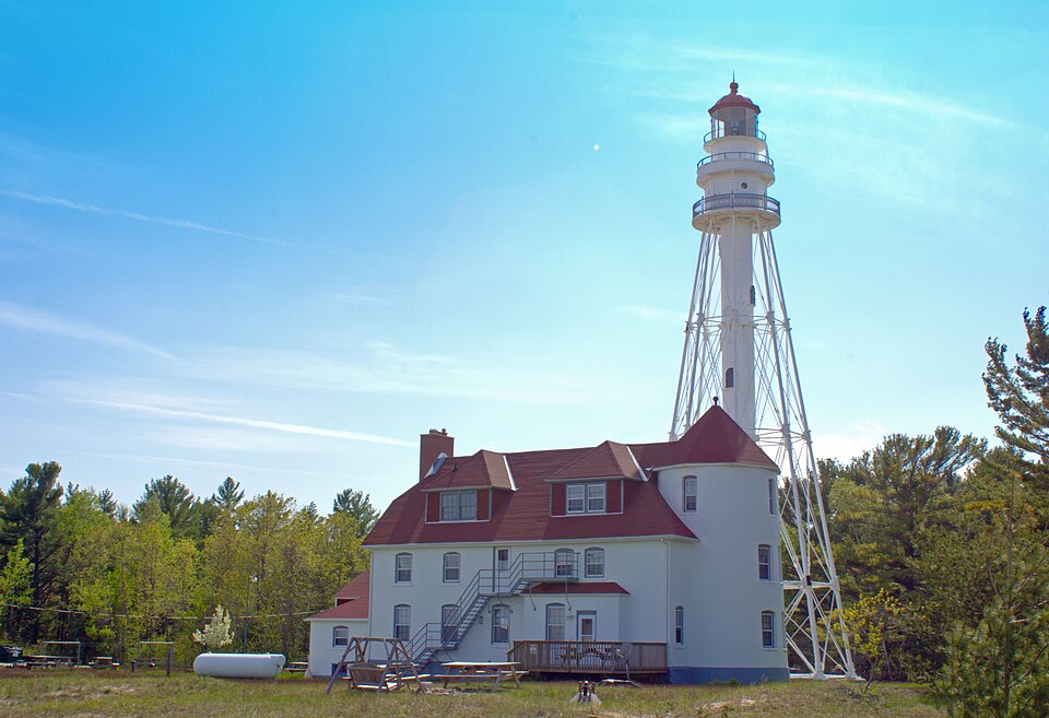
Photograph of Rawley Point Light
Photograph by Shadle, CC BY-SA 3.0. Via Wikimedia Commons.

Rawley Point Light Station

Built in 1873. Listed on the National Register of Historic Places in 1984.

From the record

“Rawley Point Light is a lighthouse located in Point Beach State Forest, near Two Rivers, Wisconsin. At 111 feet (34 m) tall, it is the tallest lighthouse on the Wisconsin Shore and it is listed on the National Register of Historic Places.”

Wikipedia article Rawley Point Light, CC BY-SA 4.0.

One of 38 National Register listings published here for Manitowoc County · listed in 1984 · category: Structure · built in 1873.

Sources: the Wikipedia article · the case file at the National Archives · the National Register database, National Park Service
The listing

  • What is counted as historic. The nomination lists 1 building, 1 structure as contributing to the listing.
  • Address. Point Beach State Forest, Two Rivers, 54241
  • When was it listed? July 1984
  • Category. structure
  • Also known as. U.S. Coast Guard Lighthouses and Light Stations on the Great Lakes TR
  • Town. Two Rivers town
  • When was it built? 1873
  • National Register reference number. 84003706 - the number the National Park Service assigned this property when it was listed, and the key its nomination file is catalogued under at the National Archives.

The ground it stands on

1,303 words

The chapter on Two Rivers Town in A History of Manitowoc County, published 1904 names Two Rivers. This is what it says, exactly as the scans read.

The village of Two Rivers was set off from the town of the same name and a charter g-ranted to it on March 31 1858. It was divided into two wards, Washington street being the line of demarkation and the first Tuesday in May was fixed as the annual election da}-. The elective officers included a president, marshal, treasurer and three supervisors and one assessor per ward, while the clerk, harbormaster and minor officers were made appointive. According to the charter the first election was held in May 1858 and H. C. Hamilton, a Democrat was chosen president. He was succeeded by H. S. Pierpont in 1859, Edward Mueller in I860, J. B. Burns in 1861, David Smoke in 1862 and then by John Oswald, who served as president three years. During this time the village was progressing rapidly. In 1862 the legislature authorized bridges on the East Twin at Main street and over the West Twin at Washing-ton, Jefferson and Monroe streets. This act was repealed two years later and the village trustees given all authority over bridges, an authority which they soon acted upon, for the only bridge then in existence was that on Washington street erected by the county in 1849. Structures at a cost of $3600 were built at Washington and Walnut streets in 1865, J. Mann being the contractor. Street improvement was also pushed and adequate means of fire protection devised. Joseph Mann was elected president in 1866, after whom E. Mueller served another term, John Oswald two terms, Andrew Baetz one and J. M. Conine one. Then in 1872 B. F. Richter was honored, after whom Mr. Conine was again elected for two terms, serving until 1875.

Passage source: A History of Manitowoc County, published 1904.

In December 1868 the Two Rivers Excelsior Engine company was organized with H. Smith as foreman and also the Dexter Hook & Ladder Co. with George Burnell as foreman. A fireman's tournament was held in the village a year later and these organizations were very active factors for several years. In 1871, however, a steam fire engine was purchased and the department reorganized, a new fire station being erected in 1874 at a cost of $5000, the building also being used as a town hall. Several amendments to the charter were made during these years, one in 1868 in regard to the duties of the clerk and treasurer, one in 1870 containing minor provisions and one in 1871, changing the election day to the first Tuesday in April. Louis Zander became village president in 1875, then J. M. Conine served another term and he in turn was succeeded by B. F. Richter in 1877. A movement was then on foot looking towards the securing of a city charter and efforts in that direction were rewarded by the legislature in the grant of such a document on March 18 1878. By this charter three wards were created, Jefferson street being the dividing line between the first and the second and the third consisting of that portion of the city west and south of the West Twin. Annual elections were to be held on the first Tuesday in April at which a mayor, assessor, treasurer and two aldermen, one constable and one justice of the peace for each ward were to be elected. Each ward was g-iven representation in the couniy board, this being- a change from the system that had prevailed since 1870, by which the village as a whole was given but one representative in that body. The mayor was g-iven no veto power but could cast a vote in case of a tie. The council was given the power of appointing a clerk, marshal, harbor master and other minor officers and also possessed the usual powers given to similar bodies. The city was constituted as one school district and one school commissioner was appointed by the council to represent each ward in matters pertaining to education. The first election held under the charter resulted in the choice of M. Maloy as mayor and E. Hammel as treasurer and the council was constituted as follows: - F'irst Ward, U. Niquette and H. Lohman; Second Ward, R. E. Mueller and Joseph Schwab; Third Ward, Peter Stout and A. Wehausen. For many years the cit}' officers in Two Rivers were kept out of partisan strug-gle, each spring a general caucus of citizens determiningwho should be the candidates and the election being merely a form of ratification. Mayor Maloy was reelected in 1879 and was succeeded a 3"ear later by W. F. Nash, Mr. Maloy beingag-ain chosen in 1881. Next Andrew Baetz held the office for two years, his administration witnessing the construction of anew bridge on Washington street and other improvements. Considerable money was also spent at and before this time in dredging the harbor. Mayor Baetz wassucceeded by William Hurst for two years, who in turn gave way to B. H. Wilkens, who served four terms or until 1890, when B. F. Richter was chosen for a year. In 1891 two tickets were placed in the field, L. C. Traverse being the candidate of the Union Party and R. E. Mueller of the Democrats. The latter was elected, carrying all but the third ward. In this year the charter was wholly revised. Among the changes made were the creation of' the offices of police justice, surveyor and school commissioners, five in number, the latter to be elected by the people and to hold office for three years, and the institution of a board of review, consisting of the ma3'or, assessor, clerk, and one alderman from each ward, whose duty it should be tq equalize the citj' tax roll. Added powers were also given to the ccuncil in the way of maintaining- parks and soon after improvements were made on the public square.

Passage source: A History of Manitowoc County, published 1904.

Machine-read from a century-old scan, so expect the errors a machine makes: misspelled names, dropped words, stray characters.

Read the whole chapter on Two Rivers Town - 1,303 words on its settlement, mills, schools and churches.

Fires near this property

2 since 1994

Regional context, not property-specific evidence. The federal wildfire occurrence database lists 2 fires within 5 miles of Rawley Point Light Station between 1994 and 2018, burning about 5 acres in total. None started naturally. None was recorded as arson. Distance is straight-line from the map coordinates, so a fire counted here may appear on a neighbouring settlement's page as well.

Reported cause Fires
Missing data/not specified/undetermined2

The most recent of them, most recent first, with the day each was reported and the service that recorded it.

DateCause SizeReported by Name on the report
10 April 1994Missing data/not specified/undetermined5.0 acresWisconsin Department of Natural Resourcesnot named
3 November 2018Missing data/not specified/undeterminedunder an acreWisconsin Department of Natural Resources180124

Every fire recorded in Manitowoc County

Storms near this property

16 since 2000

Regional context, not property-specific evidence. The National Weather Service names Two Rivers, the town this property stands in, in 16 storm reports between 2000 and 2024: 7 thunderstorm wind, 6 hail, 1 lightning, 1 flood. No death or injury is recorded in these reports. Each account below is quoted exactly as the forecast office filed it, from the NOAA Storm Events Database, and each date opens the federal record of that event.

WhenEvent Place namedHarm What the report says
March 2019FloodTwo Rivers$170,000Runoff from rainfall and snow melt combined with ice jams to cause flooding on rivers, streams and roads in the vicinity of Manitowoc and Two Rivers. Some residents living near the West Twin River had to be evacuated while county emergency crews worked to contain the overflowing Shoto Dam. The runoff also caused flooding of other low-lying and poor drainage areas. Two homes sustained major flood damage, and four homes and one business sustained minor damage. Some roads were also damaged by the flooding and required repairs after the water receded. The Manitowoc River reached major flood stage just west of Manitowoc, reaching a (preliminary) record stage of 13.58 feet. A county-wide state of emergency was declared on March 15th.
July 2021Flash FloodTwo Rivers$28,000Several rounds of thunderstorms dumped rainfall amounts of 3 to 5 inches during the afternoon and evening hours of July 14. Numerous reports of flooded and impassable roads were reported in Manitowoc and surrounding areas.
July 2012Thunderstorm WindTwo Rivers$4,500Thunderstorms produced a wind gust estimated at 65 mph that downed trees, one of which fell on a car, as they moved through Two Rivers. The storms also produced dime size hail as they passed.
April 2024Thunderstorm WindTwo Rivers-Winds from a decaying line of showers caused wind damage in Two Rivers. The winds uprooted some trees, pushed over a fence, and snapped a few power poles.
June 2022HailTwo Rivers-Half dollar size hail fell in Two Rivers.
June 2022HailTwo Rivers-Ping pong size hail fell near Two Rivers.
June 2021HailTwo Rivers-Penny size hail fell in Two Rivers.
July 2019Thunderstorm WindTwo Rivers-Thunderstorm winds downed trees in Two Rivers. The time of this event is an estimate based on radar data.
June 2016Thunderstorm WindTwo Rivers-Thunderstorm winds downed trees in Two Rivers, knocking out power to the west side of town.
August 2013Thunderstorm WindTwo Rivers-The public reported that many trees and powerlines were knocked down on the north side of Two Rivers.
July 2012HailTwo Rivers-Quarter size hail fell at Two Rivers.
July 2012HailTwo Rivers-A thunderstorm produced golf ball size hail and strong winds at Two Rivers. The winds downed a flag pole and threw chairs across a yard.
July 2006Thunderstorm WindTwo Rivers-no account filed
June 2002LightningTwo Rivers-no account filed
August 2001HailTwo Rivers-no account filed
July 2000Thunderstorm WindTwo Rivers-no account filed

Every storm recorded in Manitowoc County

Map coverage status

No historic map-sheet match is published for this property yet. That does not mean no map exists. This record needs a coordinate-quality review before it can be joined to a sheet boundary. Browse the county's mapped places while that work is pending.

Listed places nearby

6 within 8 miles

Other National Register properties close enough to walk or drive between, ordered by distance from this one. Both positions come from the same geocoding pass that matched these properties to their map sheets.

Sources for this property

National Archives recordThe nomination case file for reference 84003706 in Record Group 79.
Wikipedia articleCommunity-written account of this property, licensed CC BY-SA.
Manitowoc CountyAll 38 listed properties in this county.

Provenance

  • Listing record. National Park Service National Register of Historic Places, listed-properties dataset, current to 2026-05-22.
  • Map join. Address geocoded through the United States Census geocoder, then tested against the published boundary of every sheet in the USGS Historical Topographic Map Collection.
  • How this page is made. Listing fields come from federal records; map-sheet coverage is a labelled coordinate-to-boundary calculation, not a source-field claim.
  • Wildfire. Short, Karen C. 2022. Spatial wildfire occurrence data for the United States, 1992-2020 [FPA_FOD_20221014]. 6th Edition. Fort Collins, CO: Forest Service Research Data Archive. https://doi.org/10.2737/RDS-2013-0009.6 Collected with United States Government funding and usable without additional permissions or fees.
  • Storms. NOAA National Centers for Environmental Information, Storm Events Database https://www.ncei.noaa.gov/stormevents/ A work of the United States government, no copyright under 17 U.S.C. 105. Narratives are quoted verbatim from the National Weather Service report and are not edited or summarised.