 Block
Bexar, Alabama
8 topographic sheets cover this place, the earliest surveyed in 1956 and the latest in 1984. It stands in the Bexar census division. It lies in ZIP code area 35570. It stands on Hurricane Creek. The Survey maps it on the Bexar quadrangle.
On record in Bexar
Buildings and businesses the archive holds for this place. Each opens its own page, with the source record it came from.
Surveyed buildings and structures 1 record
- Apothecary, County Road 13, Bexarfederal building survey, 4 photographs
Topographic sheets covering this place
5 surveys from 8 printed sheetsMatched by testing this settlement's coordinate against the published boundary of every sheet in the United States Geological Survey's historical collection. Each opens the scanned sheet at the Survey.
- 1956 USGS Tupelo quadrangle1:250000, 2 printings
- 1958 USGS Tupelo quadrangle1:250000
- 1967 USGS Bexar quadrangle1:24000
- 1984 USGS Tupelo quadrangle1:250000, 3 printings
- 1984 USGS Tupelo quadrangle1:100000
Photographs
1 photograph,Taken for the Office of War Information and the Farm Security Administration, who photographed the country between 1935 and 1944. Works of United States government photographers, with no known restriction on use. Each opens its catalogue record.
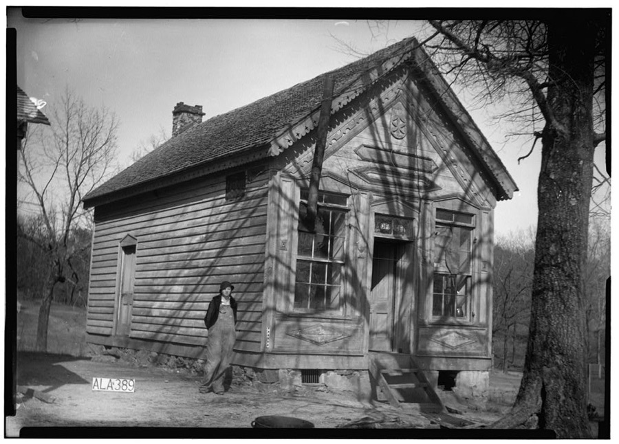
Photographer not recorded. Library of Congress
Fires near this place
184 since 1992Regional context, not property-specific evidence. The federal wildfire occurrence database lists 184 fires within 5 miles of Bexar between 1992 and 2019, burning about 1,751 acres in total. None started naturally. 109 were recorded as arson. Distance is straight-line from the map coordinates, so a fire counted here may appear on a neighbouring settlement's page as well.
| Reported cause | Fires |
|---|---|
| Arson/incendiarism | 109 |
| Debris and open burning | 43 |
| Missing data/not specified/undetermined | 21 |
| Equipment and vehicle use | 6 |
| Misuse of fire by a minor | 2 |
| Other causes | 1 |
| Power generation/transmission/distribution | 1 |
| Smoking | 1 |
The most recent of them, most recent first, with the day each was reported and the service that recorded it.
| Date | Cause | Size | Reported by | Name on the report |
|---|---|---|---|---|
| 7 September 1998 | Debris and open burning | 3.3 acres | Alabama Forestry Commission | not named |
| 6 September 1999 | Arson/incendiarism | 8.0 acres | Alabama Forestry Commission | not named |
| 6 September 1999 | Arson/incendiarism | 5.0 acres | Alabama Forestry Commission | not named |
| 6 September 1998 | Arson/incendiarism | 2.0 acres | Mississippi Forestry Commission | not named |
| 5 September 2010 | Missing data/not specified/undetermined | 4.0 acres | Mississippi Forestry Commission | MS0 1010-1290905008 |
| 5 September 1999 | Arson/incendiarism | 10 acres | Alabama Forestry Commission | not named |
| 5 September 1999 | Arson/incendiarism | 15 acres | Alabama Forestry Commission | not named |
| 4 September 2019 | Missing data/not specified/undetermined | under an acre | Alabama Forestry Commission | 20190904-3 |
Settlements close enough to share some of these fires:
Mines and quarries near this place
4 within 5 milesRegional context, not property-specific evidence. The federal mineral resources record lists 4 workings within 5 miles of Bexar: 3 past producers, 1 producer. 1 still produces. What was taken out: Sand and Gravel, Construction. Distance is straight-line from the map coordinates, so a quarry counted here may appear on a neighbouring settlement's page as well.
| Where | Site | Commodity | Status | Recorded |
|---|---|---|---|---|
| Gann Pit | Sand and Gravel, Construction | Past Producer | ||
| Robinson Mine & Mill | Sand and Gravel, Construction | Producer | ||
| Sand and Gravel Pit | Sand and Gravel, Construction | Past Producer | ||
| Sand and Gravel Pit | Sand and Gravel, Construction | Past Producer |
Storms near this place
19 since 2000Regional context, not property-specific evidence. The National Weather Service names Bexar in 19 storm reports between 2000 and 2024: 8 hail, 5 thunderstorm wind, 3 tornado, 2 flash flood. The reports record 7 deaths and 100 injuries. Each account below is quoted exactly as the forecast office filed it, from the NOAA Storm Events Database, and each date opens the federal record of that event.
| When | Event | Place named | Harm | What the report says |
|---|---|---|---|---|
| April 2011 | Tornado (EF3) | Bexar | 7 killed, 100 hurt, $11,200,000 | A long track violent tornado touched down in Monroe County (See Storm Data Memphis) Mississippi, southwest of Smithville where it caused damage associated with an EF5 rating. The tornado moved northeast through Itawamba County before it crossed into Marion County, Alabama at a point near CR 93, southwest of Bexar. The tornado weakened to an EF1 rating as it entered Alabama, with winds of 110 mph . As the tornado tracked south of Bexar, a few mobile homes and outbuildings were damaged and numerous trees were snapped off and uprooted. The tornado moved across Corridor X/Future Interstate 22, near CR 33. As the tornado approached AL Hwy 19, 4 miles east southeast of Shottsville, it strengthened to an EF3 rating with winds of 160 mph, and destroyed several homes. This resulted in 6 fatalities. The tornado continued northeastward where it destroyed several single family homes and mobile homes along CR 20 and AL Hwy 187, 9 miles north of Hamilton. As the tornado approached the Marion/Franklin County line, several more houses were damaged and at least one chicken house destroyed near AL Hwy 187. Along the Alabama portion of the tornado path, hundreds of trees were downed, and at least 25 homes, mobile homes, and outbuildings were damaged or destroyed. The average path width of the Alabama portion of the tornado path was 0.5 mile (880 yds). The tornado continued into Franklin County Alabama (See Storm Data Huntsville), dissipating near Old Line Rd. |
| December 2009 | Flash Flood | Bexar | $50,000 | Numerous county, state, and US highways became flooded across Marion County, including CR-61, US-43, CR-11, US-78, and CR-52. Taylor Road in the city of Guin, and Providence Street in the city of Winfield, were also flooded. |
| May 2000 | Hail | Bexar | $15,000 | Golfball size hail was observed on US 78 between Weston and the Alabama Mississippi border near Bexar. |
| March 2010 | Hail | Bexar | $5,000 | no account filed |
| March 2004 | Thunderstorm Wind | Bexar | $3,000 | Trees were blown down around the Schottsville community |
| June 2009 | Thunderstorm Wind | Bexar | $2,000 | A few trees were blown down on future Interstate 22, about 3 miles east of the Mississippi state line. |
| June 2024 | Tornado (EF1) | Bexar | - | The tornado first touched down in eastern Itawamba County, Mississippi off Pate Rd and traveled northeast across the state line into Marion County, Alabama. Snapped and uprooted trees were observed, consistent with an EF1 tornado. The tornado reached a width of 300 yards as it dissipated along County Highway 94 near Bexar. The total path length of the tornado was 3.38 miles. Special thanks to NWS Memphis for completing this survey. |
| February 2022 | Flash Flood | Bexar | - | Whitley Creek out of its banks and flooded County Road 98. Road impassable. |
| November 2022 | Thunderstorm Wind | Bexar | - | Several trees uprooted in the town of Bexar. |
| February 2019 | Thunderstorm Wind | Bexar | - | Several trees uprooted near Kemp Chapel Church on Highway 19. |
| March 2017 | Hail | Bexar | - | Hail covering the ground with sizes ranging from dimes to quarters. |
| October 2014 | Tornado (EF0) | Bexar | - | National Weather Service meteorologists surveyed the damage in western Marion County and have determined that the damage was the result of an EF-0 tornado. A weak tornado touched down north of Interstate 22/US Highway 78 northeast of the intersection of Taylor Road and County Road 11. Along County Road 11, ten to twenty pine trees were uprooted in a convergent pattern, with damage caused to a church by falling trees. The tornado paralleled County Road 11 briefly, causing mainly sporadic tree damage, and then continued northeast over open fields and forest. As it crossed County Road 157 north of County Road 56, several trees were uprooted and tin was pealed back on a farm building. It continued northeastward with very minor damage, crossing County Road 309 and Reid Road. The last damage along the path occurred on County Road 13 just west of Alabama Highway 19, where several pine trees were uprooted. The tornado dissipated rapidly beyond this point. |
| July 2003 | Hail | Bexar | - | Penny size hail was reported along US 78 near Exit 3. |
| March 2013 | Hail | Bexar | - | no account filed |
| March 2012 | Hail | Bexar | - | no account filed |
| May 2012 | Hail | Bexar | - | no account filed |
| December 2008 | Thunderstorm Wind | Bexar | - | no account filed |
| March 2007 | Funnel Cloud | Bexar | - | no account filed |
| April 2006 | Hail | Bexar | - | no account filed |
Nearest settlements
The eight closest, with where each one stands in the county. Distances are straight-line, computed from the Geographic Names Information System coordinates.
| Map | Place | Distance | Sheets |
|---|---|---|---|
| Shottsville | 4.9 miles | 8 | |
| Barnesville | 5.1 miles | 9 | |
| Weston | 6.5 miles | 9 | |
| Byrd | 7.7 miles | 10 | |
| Pleasant Ridge | 8.4 miles | 10 | |
| Hamilton | 9.1 miles | 10 | |
| Fulton Bridge | 10.1 miles | 8 | |
| Pigeye | 13.9 miles | 12 |
Provenance
This settlement is recorded in the Geographic Names Information System as feature 114199. The sheet list is computed by point-in-boundary test against the United States Geological Survey's historical topographic inventory. Both are works of the United States government and carry no copyright under 17 U.S.C. 105.
Wildfire. Short, Karen C. 2022. Spatial wildfire occurrence data for the United States, 1992-2020 [FPA_FOD_20221014]. 6th Edition. Fort Collins, CO: Forest Service Research Data Archive. https://doi.org/10.2737/RDS-2013-0009.6 Collected with United States Government funding and usable without additional permissions or fees.
Mines and quarries. USGS Mineral Resources Data System (MRDS) https://mrdata.usgs.gov/mrds/ A work of the United States government, no copyright under 17 U.S.C. 105.
Storms. NOAA National Centers for Environmental Information, Storm Events Database https://www.ncei.noaa.gov/stormevents/ A work of the United States government, no copyright under 17 U.S.C. 105. Narratives are quoted verbatim from the National Weather Service report and are not edited or summarised.