 Block
From the record
17 National Register listings published here.
Sources: the National Register database, National Park Service
43 topographic sheets cover 49 settlements here, and 17 properties are on the National Register of Historic Places.
17 National Register listings published here.
Sources: the National Register database, National Park Service
Every property in this county listed on the National Register of Historic Places, with the year it was listed and the federal nomination document.
| Photograph | Property | Type | Listed | Reference |
|---|---|---|---|---|
 | Augusta Commercial Historic District | district | 2008 | 08000817 |
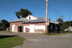 | Augusta Electrical Generating Plant | building | 2010 | 10000788 |
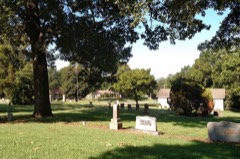 | Augusta Memorial Park Historic Section | site | 2003 | 03000507 |
 | Augusta Presbyterian Church | building | 1986 | 86002873 |
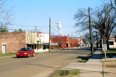 | Cotton Plant Commercial Historic District | district | 2008 | 08000946 |
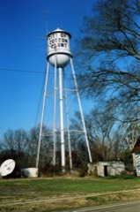 | Cotton Plant Water Tower | structure | 2008 | 08000490 |
 | Ferguson House | building | 1975 | 75000419 |
 | Fitzhugh Snapp Company | building | 2005 | 04001069 |
| George Washington Carver High School Home Economics Building | building | 2004 | 03001381 | |
 | Gregory House | building | 2012 | 12000858 |
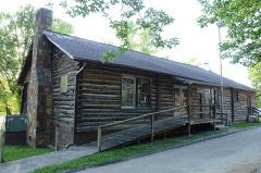 | Jess Norman Post 166 American Legion Hut | building | 2001 | 01001100 |
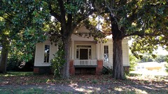 | Mathis-Hyde House | building | 2011 | 11000304 |
| McCrory Commercial Historic District | district | 2010 | 10000781 | |
 | McCrory Waterworks | structure | 2007 | 07000968 |
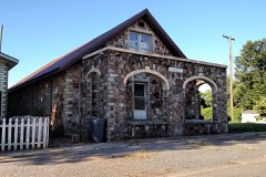 | Dr. John William Morris Clinic | building | 2009 | 09000801 |
| Revel General Store | building | 2003 | 03000952 | |
 | Woodruff County Courthouse | building | 1982 | 82000959 |
Every wildfire the federal occurrence database records inside this county: 79 of them, burning about 1,556 acres. 2 started naturally and 29 were recorded as arson. Each settlement page carries the fires within five miles of it.
| Reported cause | Fires |
|---|---|
| Arson/incendiarism | 29 |
| Debris and open burning | 24 |
| Smoking | 16 |
| Recreation and ceremony | 4 |
| Missing data/not specified/undetermined | 3 |
| Natural | 2 |
| Equipment and vehicle use | 1 |
The five largest, by the area the report gives. Two of them were set deliberately.
| Date | Cause | Size | Reported by | Name on the report |
|---|---|---|---|---|
| 1 September 2007 | Smoking | 210 acres | Arkansas Forestry Commission | not named |
| 29 October 2000 | Debris and open burning | 156 acres | Central Arkansas Refuges Complex | HOWELL |
| 27 June 2008 | Debris and open burning | 155 acres | Arkansas Forestry Commission | not named |
| 18 November 2014 | Arson/incendiarism | 126 acres | Cache River National Wildlife Refuge | WILDWOOD |
| 10 September 1999 | Debris and open burning | 119 acres | Arkansas Forestry Commission | not named |
| 14 March 2010 | Smoking | 75 acres | Cache River National Wildlife Refuge | REVEL |
| 14 March 1992 | Arson/incendiarism | 56 acres | Central Arkansas Refuges Complex | MORRIS |
| 19 November 1999 | Debris and open burning | 55 acres | Arkansas Forestry Commission | not named |
Every settlement page carries the fires within five miles of it - see the settlement index below.
The NOAA Storm Events Database holds 599 reports for this county, causing 32 deaths, 223 injuries and about $18,239,100 in recorded property damage. Each settlement page carries the reports that name it.
| Kind of event | Reports |
|---|---|
| Flood | 380 |
| Thunderstorm Wind | 110 |
| Hail | 46 |
| Tornado | 36 |
| Flash Flood | 19 |
| Heavy Rain | 4 |
| Lightning | 2 |
| Funnel Cloud | 2 |
The most serious of them, by death, then injury, then recorded damage. The accounts are quoted exactly as the forecast office filed them.
| When | Event | Place named | Harm | What the report says |
|---|---|---|---|---|
| March 1952 | Tornado (F4) | not stated | 29 killed, 180 hurt, $2,500,000 | no account filed |
| November 1995 | Tornado (F2) | Des Arc | 2 killed, 1 hurt | The tornado first touched down in an open field four miles NNW of Des Arc. It then moved northeastward destroying a barn, taking a roof off a house, taking part of a roof off another house, overturning a large combine, and blowing down trees and power lines. The tornado then struck a frame house, completely destroying it and spreading the remains of the house across a field. Two people in the house were blown about 250 yards into the field and killed. An infant in the house was carried about 300 yards into the field and was injured. Two pick-up trucks at the home were overturned and blown into the field. Numerous trees were also blown down along the path of the tornado. The tornado weakened as it neared the White River and crossed into Woodruff County around 2308 CST. The tornado lifted shortly after crossing into Woodruff County. M26PH, F36PH |
| December 1982 | Tornado (F3) | not stated | 1 killed, $2,500,000 | no account filed |
| March 1961 | Tornado (F3) | not stated | 12 hurt, $250,000 | no account filed |
| February 1960 | Tornado (F3) | not stated | 10 hurt, $25,000 | no account filed |
| May 1955 | Tornado (F2) | not stated | 7 hurt, $250,000 | no account filed |
| March 2006 | Tornado (F2) | Morton | 4 hurt | A strong tornado was spawned in Woodruff County about 4 miles southwest of Morton. The tornado tracked quickly through Morton before exiting into Cross County. The tornado damaged 18 homes in Woodruff County. A large metal building housing a welding shop was destroyed. A church lost a large part of its roof, with several windows blown out. A hunting lodge also suffered considerable roof damage. Several large grain bins were damaged, and a number of outbuildings were destroyed. Numerous power lines and power poles were blown down, with dozens of trees snapped or uprooted. |
| December 2021 | Tornado (EF2) | Augusta | 3 hurt, $500,000 | This tornado developed just north of Augusta, west of Arkansas Highway 33, moving northeast, severely damaging homes and uprooting or snapping trees in the neighborhood along Sinclair Street and power lines were downed. As the tornado moved northeast it severely damaged farm buildings along Raspberry Lane/Woodruff County Road 260. The tornado continued over rural farm land, eventually crossing Arkansas Hwy. 17 between Tupelo and Overcup, lifting just east of Arkansas Hwy. 17 south of Overcup. The 3 injuries were just north of Augusta. Two farm shops and several grain bins were destroyed. Extensive damage was noted on the north side of Augusta. |
| March 1976 | Tornado (F3) | not stated | 2 hurt, $250,000 | no account filed |
| March 1950 | Tornado (F2) | not stated | 2 hurt | no account filed |
| January 1978 | Tornado (F3) | not stated | 1 hurt, $25,000 | no account filed |
| March 1986 | Thunderstorm Wind | not stated | 1 hurt | no account filed |
| March 2008 | Flood | Fitzhugh | $3,500,000 | Heavy rain caused the White River at Augusta to go above major flood level. The river was above minor flood level at the start of the event, but continued to rise due to heavy rains. Houses on 4th Street in Augusta were surrounded by water. The Horseshoe Lake community was underwater. About 30 homes, most of them in the Taylor Bay community, were flooded. Agricultural losses were to winter wheat and delayed planting of corn and grain sorghum. Many acres of wheat were also recently fertilized to compound the losses. County roads were flooded, especially in the Taylor Bay portion of the floodplain. Portions of Arkansas Highway 33 north of Augusta were flooded. The flooding continued into April. |
| June 2014 | Flash Flood | Fitzhugh | $1,820,000 | Rainfall measured 9.75 inches 4 miles west of Cotton Plant, 9.70 inches at Howell, 7.50 inches at Augusta, and 7.45 inches at McCrory. About 40 homes flooded around Augusta, Patterson, and McCrory, and about 26 homes and businesses flooded around Cotton Plant. Arkansas 145 and numerous county roads were flooded, as were farm fields. The University of Arkansas Cooperative Extension Service reported that 15,000 acres of soybeans were flooded in the county. |
| May 2011 | Flood | Fitzhugh | $1,500,000 | Part of Arkansas Highway 33 was closed due to flooding. At the height of the flooding, boats were parked on the courthouse lawn in Augusta. Evacuations were necessary in McClelland, Gregory, Cotton Plant, and Patterson. Flooding in Woodruff County continued into June. |
| March 2008 | Flood | Overcup | $500,000 | Heavy rain caused the Cache River at Patterson to go above flood stage. The river was above flood stage to start the event and continued as three significant rainfall events occurred during the month to refresh the flooding. County roads were damaged by the flooding and agricultural losses were to pastures and winter wheat. The flooding continued into April. |
| March 1997 | Tornado (F2) | Patterson | $500,000 | no account filed |
| May 2013 | Flash Flood | Fitzhugh | $325,000 | Heavy rain caused considerable damage to county roads and bridges. |
| May 2010 | Tornado (EF1) | Bemis | $300,000 | A hangar at a flying service had part of its roof taken off and one wall caved in. A house had part of its roof and parts of two walls blown off. Trees, power poles, and power lines were blown down. This tornado exited Woodruff County north-northeast of Penrose and moved into Cross County south-southwest of Fair Oaks, in the Memphis County Warning Area. |
| December 2009 | Flood | Fitzhugh | $250,000 | Flash flooding, which developed early on the morning of the 24th, became widespread areal flooding later in the morning on the 24th and continued into Christmas morning. Numerous county roads and state highways were flooded. City streets in McCrory were flooded as well. |
| December 2009 | Flash Flood | Fitzhugh | $250,000 | Widespread heavy rain led to flash flooding early on the morning of the 24th. |
| November 1983 | Tornado (F1) | not stated | $250,000 | no account filed |
| December 1982 | Tornado (F2) | not stated | $250,000 | no account filed |
| April 1978 | Tornado (F2) | not stated | $250,000 | no account filed |
| June 2014 | Lightning | Mc Crory | $150,000 | A fire started by lightning destroyed a house. Lightning struck a pine tree behind the house, then traveled along the wiring for an old satellite dish to the house's attic, setting the attic on fire. |
| April 2008 | Flood | Ona | $150,000 | Major flooding was repeated along the White River at the Augusta river gage. Homes along Taylor Bay and near the City of Augusta were flooded again by the second major rise in less than a month. After rising in March to the highest level since completion of the flood control reservoirs, the river crested a half foot below that level in April. The April crest was the third highest since the reservoirs were completed in the middle of the twentieth century. Dollar losses were limited to whatever repairs were made to the previous flood damages. |
| October 2009 | Flash Flood | Fitzhugh | $125,000 | Numerous county roads were damaged by flash flooding. |
| April 2011 | Flood | Fitzhugh | $100,000 | Widespread areal flooding occurred. Part of Arkansas Highway 33 was closed by flooding on the evening of the 30th. |
| June 2009 | Thunderstorm Wind | Mc Crory | $100,000 | Trees and power lines were blown down. A farm shop suffered extensive damage. |
| May 2013 | Thunderstorm Wind | Augusta | $75,000 | A metal building at a truck supply store was destroyed, part of the canopy at a gas station was damaged, and a number of trees were blown down. A couple of the trees landed on structures, including a house and garage. |
| June 2009 | Thunderstorm Wind | Augusta | $75,000 | A boat dock on the White River was blown onto the shore in the Taylor Bay area. One power pole and three trees were down. |
| May 2008 | Tornado (EF1) | Tipp | $60,000 | The tornado destroyed a tractor shed that was 50 feet by 70 feet, and a carport. Trees and power lines were knocked down as well. The tornado exited Woodruff County, southeast of Morton, and continued into Cross County (WFO Memphis County Warning Area), south of Fair Oaks. |
| May 2019 | Thunderstorm Wind | Mc Crory | $50,000 | A small microburst blew down some trees and tree limbs, and caused damage around the baseball field in Augusta. |
| August 2011 | Thunderstorm Wind | De View | $50,000 | Trees and power poles were blown down. Some trees had to be cut out of the road. |
| December 2009 | Flood | New Augusta | $50,000 | Heavy rainfall in early December, combined with planned reservoir releases, caused the White River at Augusta to rise above flood stage on the 3rd. This river remained above flood stage through the rest of December and into January, aided by additional very heavy rainfall on the 23rd and 24th. Thousands of acres of cropland and several rural roads became inundated due to the high water. |
| June 2009 | Thunderstorm Wind | Augusta | $50,000 | Trees were uprooted and limbs were down across the area. One tree fell on a house. |
| July 1994 | Thunderstorm Wind | Augusta | $50,000 | Thunderstorm winds downed some power lines and a utility pole. |
| September 1994 | Thunderstorm Wind | Augusta | $50,000 | Thunderstorm winds downed two large trees and some power lines. |
| March 1994 | Hail | not stated | $50,000 | Hail up to softball-size damaged several roofs and vehicles in McCrory. |
| April 2014 | Thunderstorm Wind | De View | $40,000 | A carport was destroyed, much of the roof was blown off a mobile home, several other roofs were damaged, and trees and power lines were blown down. |
| January 2007 | Flash Flood | Mc Crory | $31,600 | Numerous roads across Woodruff County were flooded due to heavy rainfall. |
| June 2011 | Thunderstorm Wind | Mc Crory | $30,000 | A truck was blown over. |
| April 2011 | Thunderstorm Wind | Mc Crory | $30,000 | Trees were blown down on McCrory. Some roofs were damaged by the falling trees. |
| March 1992 | Tornado (F1) | not stated | $25,000 | no account filed |
| December 1982 | Tornado (F0) | not stated | $25,000 | no account filed |
| December 1982 | Tornado (F1) | not stated | $25,000 | no account filed |
| December 1982 | Tornado (F1) | not stated | $25,000 | no account filed |
| April 1979 | Tornado (F1) | not stated | $25,000 | no account filed |
| May 1973 | Tornado (F4) | not stated | $25,000 | no account filed |
| March 1952 | Tornado (F3) | not stated | $25,000 | no account filed |
| August 2020 | Tornado (EF0) | Goodrich | $20,000 | A storm survey crew from the NWS Office in Little Rock found tornado damage consistent with an EF0 rating. ||This tornado formed just northeast of the intersection of highways|37 and 269 north of McCrory, where a covered parking area roof was|blown west. At that same residence, a large tree fell southwest|onto the home. This tornado continued northwest over cropland,|pushing over a power pole off County Road 338, then proceeded to|cross State Highway 17 blowing down more trees and tree limbs.|This tornado lifted shortly afterwards to the northwest. |
| June 2013 | Flood | Patterson | $20,000 | Heavy rainfall during the spring kept the Cache River at Patterson above flood stage from April through the first half of June. The river finally fell below flood stage during the afternoon hours on the 16th. |
| June 2013 | Flood | Augusta | $20,000 | Heavy rainfall from late May into early June caused the White River at Augusta to rise above flood stage during the evening hours on May 31st. The river remained above flood stage through the first half of June, then fell below flood stage during the early morning hours on the 15th. |
| December 2011 | Flood | Augusta | $20,000 | Additional heavy rainfall as well as routed water from upstream dams kept the White River at Augusta above flood stage throughout December. |
| June 2009 | Thunderstorm Wind | Dixie | $20,000 | Trees and power poles were blown down. |
| June 2009 | Thunderstorm Wind | Augusta | $20,000 | Trees were blown down. |
| July 2014 | Thunderstorm Wind | Augusta | $15,000 | Trees were blown down in Augusta. |
| November 2011 | Flood | Augusta | $15,000 | Heavy rainfall caused the White River near Augusta to rise above flood stage during the early morning hours on the 23rd. This river reached over 30 feet during the month of November and minor flooding continued through the end of the month. |
| June 2011 | Thunderstorm Wind | Hunter | $15,000 | Trees were blown down, with some of the trees falling on power lines. |
| April 2011 | Flood | Mc Clelland | $15,000 | no account filed |
The Survey's mineral resources record lists 6 workings inside this county. 1 still produces and 5 are closed or unrecorded. Each settlement page carries the workings within five miles of it.
| Commodity | Workings |
|---|---|
| Sand and Gravel, Construction | 6 |
The least common of them first, because a county's hundredth gravel pit says nothing its first ten did not.
| Where | Site | Commodity | Status | Recorded |
|---|---|---|---|---|
| River Sand and Gravel Dredge | Sand and Gravel, Construction | Producer | ||
| Unk | Sand and Gravel, Construction | Past Producer | ||
| Unk | Sand and Gravel, Construction | Past Producer | ||
| Unk | Sand and Gravel, Construction | Past Producer | ||
| Unk | Sand and Gravel, Construction | Past Producer | ||
| Unk Sandpits 2 | Sand and Gravel, Construction | Past Producer |
Named settlements recorded in the Geographic Names Information System, each with the topographic sheets covering it. Villages, hamlets and abandoned places alike. Each is shown with the nearest named watercourse or landform and the survey quadrangle it falls on.
Augusta township · 72006 · On Goose Pond Slough · Augusta quadrangle
12 sheets, 1935 to 1986
Cotton Plant township · 72101 · On Moore Creek · Gregory quadrangle
13 sheets, 1935 to 1986
No longer a settlement
Cotton Plant township · 72036 · On Cache Bayou · Cotton Plant quadrangle
13 sheets, 1935 to 1986
No longer a settlement
Cotton Plant township · 72036 · On Roaring Slough · Cotton Plant quadrangle
13 sheets, 1935 to 1986
Cotton Plant township · 72006 · Gregory quadrangle
13 sheets, 1935 to 1986
No longer a settlement
Cotton Plant township · 72101 · On Locust Slough · Hunter West quadrangle
13 sheets, 1939 to 1986
Cotton Plant township · 72006 · Gregory SW quadrangle
13 sheets, 1935 to 1986
No longer a settlement
Cotton Plant township · 72036 · On Roaring Slough · Cotton Plant quadrangle
13 sheets, 1935 to 1986
Cotton Plant township · 72036 · On Buffalo Creek · Hunter West quadrangle
13 sheets, 1939 to 1986
Cotton Plant township · 72074 · Hunter East quadrangle
12 sheets, 1939 to 1986
No longer a settlement
Augusta township · 72006 · Augusta quadrangle
12 sheets, 1935 to 1986
No longer a settlement
McCrory township · 72101 · Hunter East quadrangle
12 sheets, 1939 to 1986
No longer a settlement
Cotton Plant township · 72101 · McCrory quadrangle
10 sheets, 1940 to 1986
No longer a settlement
Cotton Plant township · 72101 · McCrory quadrangle
10 sheets, 1940 to 1986
No longer a settlement
McCrory township · 72101 · On Old Channel Bayou De View · McCrory quadrangle
10 sheets, 1940 to 1986
No longer a settlement
Cotton Plant township · 72101 · Near Nubbin Ridge · Grays quadrangle
12 sheets, 1939 to 1986
The vanished settlements of Woodruff County: the places named above that are no longer on the map.