 Block
Barkhamsted, Connecticut
31 topographic sheets cover this place, the earliest surveyed in 1892 and the latest in 1994. It stands in Barkhamsted town. It lies in ZIP code area 06063. It lies near Washington Hill. The Survey maps it on the New Hartford quadrangle.
On record in Barkhamsted
Buildings and businesses the archive holds for this place. Each opens its own page, with the source record it came from.
On the National Register 5 records
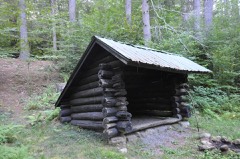 American Legion Forest CCC Shelterlisted 1986
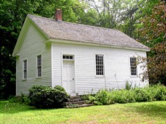 Barkhamsted Center Historic Districtlisted 1999
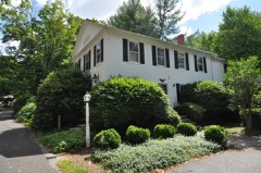 William Moore Jr. Houselisted 1999
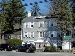 Old Riverton Innlisted 1992
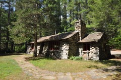 Peoples Forest Museumlisted 1986
Topographic sheets covering this place
11 surveys from 31 printed sheetsMatched by testing this settlement's coordinate against the published boundary of every sheet in the United States Geological Survey's historical collection. Each opens the scanned sheet at the Survey.
- 1892 USGS Granby quadrangle1:62500, 8 printings
- 1906 USGS Farmington quadrangle1:125000, 2 printings
- 1947 USGS Hartford quadrangle1:250000, 2 printings
- 1948 USGS Hartford quadrangle1:250000, 2 printings
- 1951 USGS New Hartford quadrangle1:31680, 2 printings
- 1956 USGS New Hartford quadrangle1:24000, 6 printings
- 1961 USGS Hartford quadrangle1:250000
- 1962 USGS Hartford quadrangle1:250000, 3 printings
- 1965 USGS Hartford quadrangle1:250000, 2 printings
- 1986 USGS Hartford quadrangle1:100000
- 1994 USGS Hartford quadrangle1:100000, 2 printings








In the county-history sources
5,901 words on this townshipHistory of Litchfield County, Connecticut, published 1881 names this settlement in its chapter on Barkhamsted Town. These are the passages that mention it, exactly as the scans read.
The territory now embraced in Barkhamsted was included in the " Western grant," made by the colony of Connecticut in trust to the towns of Hartford and AVindsor in 1686. After the division of these lands between the colony and the proprietors of Hartford and Windsor, in 1726, by a partition deed between the two towns, dated February, 1732, Barkhamsted, Torrington. West Harwinton, and Colebrook fell to the share of the Windsor patentees. Barkhamsted, which contained by estimation twenty thousand five hundred and thirty-one acres, was divided among one hundred and eight tax-payers of Windsor on the li.st of 1720. The town was named Barkhamsted by an act of the General Assembly in May, 1732,t and in January, 1733, the proprietors held their first meeting at " ye old society meeting-house in Windsor," when Henry Allyn was chosen proprietors' clerk.
Passage source: History of Litchfield County, Connecticut, published 1881.
During the summer of 1733 a committee of four was sent from Windsor to view the land, and to lay out the first division into home-lots. This division lay between the branches of the river, and eastward as far as Simsbury bounds, with one tier of lots west of the west branch of the river, the |)roi)rietors reserving two fifty-acre lots near the centre of the town and Mast Swamp. These lots were drawn by tlie proprietors in July, 1733, in the proportion of one acre to the pound on each man's list. At the same time highways were laid out, one, ten rods wide, between the branches of the river, beginning at tlie line between Barkhamsted and New Hartford, about one liundred and twenty rods eastward of the West Branch, running nortiiward to the boundary of the township. From this highway several others were laid out east and west. Tliere was also a highway four rods wide ne.\t to the Simsbury line, and reservations for higii- t Tliore hn« lieoii niurh <|ue«tlon lu to the origin of the name. The old e)]elling wa» " llerkhoiiipstcd," and the tlieoT; haa been adraiiced that eome of tlio Windsor propriotom may bare come from the Englbh town of that name.
Passage source: History of Litchfield County, Connecticut, published 1881.
The new township was a source of expense and trouble, and but little revenue, to its proprietors for forty years. Lands found few purchasers, and the country was too rugged and barren to invite settlers. The principal matters taken up in proprietors' meetings during this interval were the prosecution of trespassers convicted of cutting, felling, disposing of, or carrying away wood or timber, and the defense of the border line against encroachments from Simsbury, in which Barkhamsted made common cause with New Hartford. The committees who attended to these matters were paid by sales of timber or undivided lands of the proprietors, and the highways were cleared by sales of the timber growing thereon, funds in the treasury being low.
Passage source: History of Litchfield County, Connecticut, published 1881.
Machine-read from a century-old scan, so expect the errors a machine makes: misspelled names, dropped words, stray characters.
Read the whole chapter on Barkhamsted Town - it names this place 10 more 10 times.
Fires near this place
131 since 1997Regional context, not property-specific evidence. The federal wildfire occurrence database lists 131 fires within 5 miles of Barkhamsted between 1997 and 2020, burning about 120 acres in total. None started naturally. 6 were recorded as arson. Distance is straight-line from the map coordinates, so a fire counted here may appear on a neighbouring settlement's page as well.
| Reported cause | Fires |
|---|---|
| Missing data/not specified/undetermined | 99 |
| Debris and open burning | 12 |
| Recreation and ceremony | 10 |
| Arson/incendiarism | 6 |
| Smoking | 2 |
| Railroad operations and maintenance | 1 |
| Misuse of fire by a minor | 1 |
The most recent of them, most recent first, with the day each was reported and the service that recorded it.
| Date | Cause | Size | Reported by | Name on the report |
|---|---|---|---|---|
| 4 September 2017 | Missing data/not specified/undetermined | under an acre | Connecticut Division of Forestry | 21 COTTAGE ST |
| 30 September 2006 | Missing data/not specified/undetermined | under an acre | Connecticut Division of Forestry | not named |
| 18 September 2010 | Recreation and ceremony | under an acre | Connecticut Division of Forestry | not named |
| 11 September 2002 | Missing data/not specified/undetermined | under an acre | Connecticut Division of Forestry | not named |
| 8 August 2001 | Missing data/not specified/undetermined | under an acre | Connecticut Division of Forestry | not named |
| 5 August 2007 | Missing data/not specified/undetermined | under an acre | Connecticut Division of Forestry | not named |
| 24 August 2019 | Missing data/not specified/undetermined | under an acre | Connecticut Division of Forestry | not named |
| 22 August 2020 | Railroad operations and maintenance | under an acre | Connecticut Division of Forestry | 7 RIDGEVIEW TERRANCE |
Settlements close enough to share some of these fires:
Mines and quarries near this place
5 within 5 milesRegional context, not property-specific evidence. The federal mineral resources record lists 5 workings within 5 miles of Barkhamsted: 4 past producers, 1 prospect. None of them still produces. What was taken out: Stone, Dimension, Mica, Feldspar, Feldspar, Mica. Distance is straight-line from the map coordinates, so a quarry counted here may appear on a neighbouring settlement's page as well.
| Where | Site | Commodity | Status | Recorded |
|---|---|---|---|---|
| Knapp Mica Prospect | Mica, Feldspar | Past Producer | Muscovite, Plagioclase, Quartz | |
| Knapp Mica Prospect | Feldspar, Mica | Prospect | ||
| Pegmatite Prospect No. Di-002 | Feldspar, Quartz | Past Producer | Feldspar | |
| Pegmatite Quarry | Stone, Dimension | Past Producer | ||
| Riprap Quarry | Stone, Dimension | Past Producer |
Storms near this place
8 since 1998Regional context, not property-specific evidence. The National Weather Service names Barkhamsted in 8 storm reports between 1998 and 2020: 4 thunderstorm wind, 3 hail, 1 tornado. No death or injury is recorded in these reports. Each account below is quoted exactly as the forecast office filed it, from the NOAA Storm Events Database, and each date opens the federal record of that event.
| When | Event | Place named | Harm | What the report says |
|---|---|---|---|---|
| July 1998 | Thunderstorm Wind | Barkhamsted | $2,500 | no account filed |
| October 2020 | Thunderstorm Wind | Barkhamsted | - | Trees were downed. |
| May 2018 | Hail | Barkhamsted | - | Golf ball-sized hail was covering the ground near Barkhamsted. |
| May 2018 | Tornado (EFU) | Barkhamsted | - | Public video confirmed a tornado over the Barkhamsted Reservoir. A National Weather Service damage survey team found no damage between Winsted, CT, and the reservoir. No damage was reported over the reservoir. |
| June 2017 | Hail | Barkhamsted | - | Penny size hail was reported by a spotter during a thunderstorm 1 mile north-northwest of Barkhampsted. |
| June 2013 | Hail | Barkhamsted | - | Quarter size hail was reported during a thunderstorm in Barkhampsted Center. |
| September 2012 | Thunderstorm Wind | Barkhamsted | - | Trees were reported down due to thunderstorm winds in Barkhamsted. |
| March 2008 | Thunderstorm Wind | Barkhamsted | - | A tree and wires were reported down in Barkhamsted as a result of strong thunderstorm winds. |
Nearest settlements
The eight closest, with where each one stands in the county. Distances are straight-line, computed from the Geographic Names Information System coordinates.
| Map | Place | Distance | Sheets |
|---|---|---|---|
| Barkhampsted Center | 2.8 miles | 31 | |
| Pleasant Valley | 4.1 miles | 31 | |
| Pine Meadow | 4.6 miles | 31 | |
| New Hartford | 4.7 miles | 31 | |
| Puddle Town | 4.9 miles | 30 | |
| Riverton | 5.9 miles | 35 | |
| Town Hill | 6.9 miles | 30 | |
| Nelsons Corner | 7.3 miles | 35 |
Provenance
This settlement is recorded in the Geographic Names Information System as feature 212416. The sheet list is computed by point-in-boundary test against the United States Geological Survey's historical topographic inventory. Both are works of the United States government and carry no copyright under 17 U.S.C. 105.
Wildfire. Short, Karen C. 2022. Spatial wildfire occurrence data for the United States, 1992-2020 [FPA_FOD_20221014]. 6th Edition. Fort Collins, CO: Forest Service Research Data Archive. https://doi.org/10.2737/RDS-2013-0009.6 Collected with United States Government funding and usable without additional permissions or fees.
Mines and quarries. USGS Mineral Resources Data System (MRDS) https://mrdata.usgs.gov/mrds/ A work of the United States government, no copyright under 17 U.S.C. 105.
Storms. NOAA National Centers for Environmental Information, Storm Events Database https://www.ncei.noaa.gov/stormevents/ A work of the United States government, no copyright under 17 U.S.C. 105. Narratives are quoted verbatim from the National Weather Service report and are not edited or summarised.