Listed on the National Register of Historic Places in 1984.
From the record
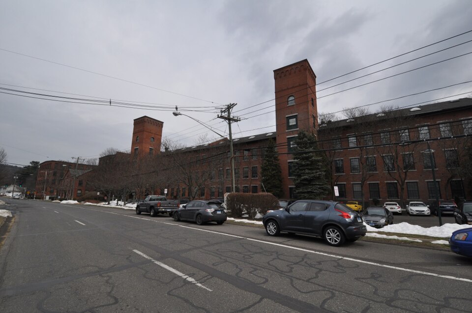
“The Home Woolen Company is a historic textile mill complex at 2 North Main Street in Beacon Falls, Connecticut. Developed between 1853 and 1916, the complex housed major local employers, engaged first in the manufacture of woolens and rubber products.”
Wikipedia article Home Woolen Company, CC BY-SA 4.0.
One of 272 National Register listings published here for New Haven County · listed in 1984 · category: Building.
National Register reference number.84000410- the number the National Park Service assigned this property when it was listed, and the key its nomination file is catalogued under at the National Archives.
The ground it stands on
4,911 words
The chapter on Beacon Falls Town in History of New Haven County, Connecticut, published 1892 names Beacon Falls. This is what it says, exactly as the scans read.
It appears singular that another Indian slave of Colonel Johnson should be connected with a land purchase in Beacon Falls, but such is the fact. One of his maid-servants was a young squaw, Sarah, who was desired by an Indian for his wife, and she was sold to him in 1709. This dusky lover was named Chetrenasut, and he secured his bride for a consideration of ,£3, 10s. of money and all that tract of land "lying in a place called ' Nayumps,' bounded northerly with Beacon Hill river, easterly with Milford, westerly with the Naugatuck river, and south with Lebanon river." This region was afterward called " Nyumps," and was the northwestern part of Bethany, set off to Beacon Falls when the town was formed. It includes the main part of the town, and on which are now its most costly improvements.
It is supposed that some of the children of Colonel Ebenezer Johnson settled on their father's land soon after the settlement of Ebenezer Riggs, and that they lived west and southeast of Rock Rimmon. At a later day Timothy Johnson, who was married to Abigail Brewster, in 172o, settled on the Naugatuck a short distance below Pines Bridge. In the same locality lived their son, Alexander, who was born in 1730 and died in 1817, aged 87 years. This Captain Alexander Johnson had a son Elijah, who occupied the homestead until his death, in 1847, at the age of 75 years. Sharpe, in his " History of Seymour," states that Timothy Johnson was at first much annoyed " by wild animals, especially bears, which came from Rock Rimmon and destroyed his crops." This locality, and in fact other parts of the town, particularly Nyumph, were also much troubled by snakes, which came out from the crevices of the rocks and often crawled into the houses of the early settlers. The Johnsons were for many years numerous at Pines Bridge and around Rock Rimmon, in what is now Beacon Falls and Seymour. In the latter town Benajah Johnson last lived, until 1763, in the locality called Skokorat. A daughter, Zeviah, born in 1739, married Abiel Fairchild, who settled not quite a mile northwest from Pines Bridge. Fairchild was reputed a most excellent man. and was greatly esteemed by his neighbors.
Regional context, not property-specific
evidence. The
federal wildfire occurrence database
lists 599 fires within 5 miles of Home Woolen Company
between 1992 and 2020, burning about 1,538 acres in total. None started naturally. 179 were recorded as arson.
Distance is straight-line from the map coordinates, so a fire counted
here may appear on a neighbouring settlement's page as well.
Reported cause
Fires
Missing data/not specified/undetermined
231
Arson/incendiarism
179
Recreation and ceremony
67
Misuse of fire by a minor
52
Debris and open burning
43
Smoking
12
Railroad operations and maintenance
8
Equipment and vehicle use
7
The most recent of
them, most recent first, with the day each was reported and the service
that recorded it.
Regional context, not property-specific
evidence. The federal mineral resources record lists
21 workings within 5 miles of Home Woolen Company: 9 producers, 8 past producers, 2 occurrences, 1 plant.
10 still produce. What was taken out: Sand and Gravel, Construction, Copper, Iron, Nickel, Arsenic. Distance is straight-line from the
map coordinates, so a quarry counted here may appear on a neighbouring
settlement's page as well.
Regional context, not property-specific
evidence. The National Weather Service names
Beacon Falls, the town this property stands in, in 10 storm reports between 2004 and 2022: 5 thunderstorm wind, 3 flash flood, 1 tornado, 1 flood.
No death or injury is recorded in these reports. Each account below is quoted exactly as the forecast office
filed it, from the NOAA Storm Events Database, and each date
opens the federal record of that event.
In Seymour, several motorists were rescued from their vehicles on the Rt. 8 bridge between exits 22 and 23. Firefighters also rescued motorists in the Pearl St. area. The bridge on North St. between Smith St. and Beach St. was closed after becoming compromised by raging waters in the Bladens River below. Many basements were flooded throughout town. Several road washouts occurred including Rt. 67 between East St. and Park Rd. and on portions of Pearl, Beach and School Streets after flood waters as deep as two ft. swept over the streets. A retaining wall in front of Walgreens on Rt. 67, between Martha St. and Old Dr., partially collapsed from the flood waters. The Seymour Land Trust property, a cherished passive recreation complex, on Chatfield St. is estimated to have suffered over $750,000 in damage when a flood of water rushed through the property and washed out bridges and trails. Paved paths buckled and crumbled due to the tremendous amount of water that rushed in. A 20-by-15 crater some 30-ft. deep was carved on the grounds. ||West Rd. in Beacon Falls was also partially washed away due to the excessive rain.||Local media reported a total of 4.25 inches of rainfall in Seymour. Total property damage is estimated.
A tornado touched down near the intersection of Bethany Road and|Bonna Street in Beacon Falls, destroyed a barn in Bethany, and|continued on to just west of Sleeping Giant State Park in Hamden,|where the damage path broadened and became more straight-line in|nature. The tornado left a path of numerous uprooted and snapped |hardwood and pine trees. Based on this information, this tornado |is classified as an EF1 with maximum winds of 110 mph.
The Naugatuck River at Beacon Falls rose above its minor flood stage of 12.0 feet at 1:15am EDT, crested at a height of 12.79 feet at 2:00am EDT, and fell back below flood stage at 5:30am EDT. This is the 6th highest crest on record for the Naugatuck River at this location.
No historic map-sheet match is published
for this property yet. That does not mean no map exists. This record needs
a coordinate-quality review before it can be joined to a sheet boundary.
Browse the county's mapped places while that work is
pending.
Listed places nearby
6 within 8 miles
Other National Register properties close
enough to walk or drive between, ordered by distance from this one. Both
positions come from the same geocoding pass that matched these properties
to their map sheets.
Listing record. National Park Service National Register of Historic Places, listed-properties dataset, current to 2026-05-22.
Map join. Address geocoded through the United States Census geocoder, then tested against the published boundary of every sheet in the USGS Historical Topographic Map Collection.
How this page is made. Listing fields come from federal records; map-sheet coverage is a labelled coordinate-to-boundary calculation, not a source-field claim.
Wildfire. Short, Karen C. 2022. Spatial wildfire occurrence data for the United States, 1992-2020 [FPA_FOD_20221014]. 6th Edition. Fort Collins, CO: Forest Service Research Data Archive. https://doi.org/10.2737/RDS-2013-0009.6 Collected with United States Government funding and usable without additional permissions or fees.
Mines and quarries. USGS Mineral Resources Data System (MRDS) https://mrdata.usgs.gov/mrds/ A work of the United States government, no copyright under 17 U.S.C. 105.
Storms. NOAA National Centers for Environmental Information, Storm Events Database https://www.ncei.noaa.gov/stormevents/ A work of the United States government, no copyright under 17 U.S.C. 105. Narratives are quoted verbatim from the National Weather Service report and are not edited or summarised.
 Block