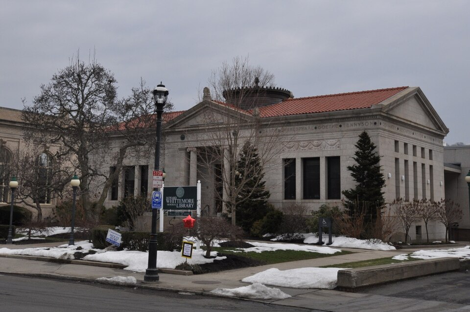
Listed on the National Register of Historic Places in 1999.
From the record
“The Naugatuck Center Historic District encompasses the historic civic and business center of Naugatuck, Connecticut. Centered around the town green, the district includes churches, schools and municipal buildings, many from the late 19th or early 20th centuries, as well as a diversity of residential architecture.”
Wikipedia article Naugatuck Center Historic District, CC BY-SA 4.0.
One of 272 National Register listings published here for New Haven County · listed in 1999 · category: District.
National Register reference number.99000859- the number the National Park Service assigned this property when it was listed, and the key its nomination file is catalogued under at the National Archives.
The principal affluents are Hop brook, in the northern part, flowing from Middlebury; Fulling Mill brook, in the northeastern part, flowing from Prospect; Beacon Hill brook, in the southeastern part and south of Hopkins' hill; Spruce brook, in the southwest; and a large brook, flowing from the southern part of Middlebury, bisecting the western half of the town and emptying into the Naugatuck river
The town was organized in 1844 and took its name from the valley in which it lies. Doctor Anderson says that the term "Naugatuck was originally attached not to the river, but to a place on the river;" and that there was plenty of evidence to show that Naugatuck, or the fishing place, was at Rimmon Falls, where Seymour now stands. The name being applied to the river, at that particular place, was soon given to the entire length, then to the valley and finally to the town.
Regional context, not property-specific
evidence. The
federal wildfire occurrence database
lists 516 fires within 5 miles of Naugatuck Center Historic District
between 1992 and 2020, burning about 1,172 acres in total. None started naturally. 147 were recorded as arson.
Distance is straight-line from the map coordinates, so a fire counted
here may appear on a neighbouring settlement's page as well.
Reported cause
Fires
Missing data/not specified/undetermined
220
Arson/incendiarism
147
Recreation and ceremony
51
Misuse of fire by a minor
48
Debris and open burning
25
Smoking
10
Railroad operations and maintenance
8
Equipment and vehicle use
6
Power generation/transmission/distribution
1
The most recent of
them, most recent first, with the day each was reported and the service
that recorded it.
Regional context, not property-specific
evidence. The federal mineral resources record lists
16 workings within 5 miles of Naugatuck Center Historic District: 8 producers, 4 past producers, 2 unknowns, 1 occurrence.
9 still produce. What was taken out: Sand and Gravel, Construction, Copper, Iron, Iodine. Distance is straight-line from the
map coordinates, so a quarry counted here may appear on a neighbouring
settlement's page as well.
Regional context, not property-specific
evidence. The National Weather Service names
Naugatuck, the town this property stands in, in 20 storm reports between 1995 and 2024: 12 thunderstorm wind, 4 flash flood, 2 lightning, 2 hail.
The reports record 2 injuries. Each account below is quoted exactly as the forecast office
filed it, from the NOAA Storm Events Database, and each date
opens the federal record of that event.
Numerous trees were reported down in Naugatuck, including a large tree into a house at 384 Hillside Avenue, and another tree on a house at 151 New Street.
Spotter reports indicate downed trees near the off/on ramps of exit 25 on Route 8 North, extending east for about 200 yards to near a commuter parking lot on Cross Street and onto Andrasko Road. Downed trees near the Route 8 ramps were facing toward the north and northwest, while those near the parking lot and on Andrasko Road were oriented east and southeast. Some healthy trees in the damage area were snapped about one-third of the way down from the top. This damage is indicative of a microburst with estimated maximum winds of about 95 mph.
No historic map-sheet match is published
for this property yet. That does not mean no map exists. This record needs
a coordinate-quality review before it can be joined to a sheet boundary.
Browse the county's mapped places while that work is
pending.
Listed places nearby
6 within 8 miles
Other National Register properties close
enough to walk or drive between, ordered by distance from this one. Both
positions come from the same geocoding pass that matched these properties
to their map sheets.
Listing record. National Park Service National Register of Historic Places, listed-properties dataset, current to 2026-05-22.
Map join. Address geocoded through the United States Census geocoder, then tested against the published boundary of every sheet in the USGS Historical Topographic Map Collection.
How this page is made. Listing fields come from federal records; map-sheet coverage is a labelled coordinate-to-boundary calculation, not a source-field claim.
Wildfire. Short, Karen C. 2022. Spatial wildfire occurrence data for the United States, 1992-2020 [FPA_FOD_20221014]. 6th Edition. Fort Collins, CO: Forest Service Research Data Archive. https://doi.org/10.2737/RDS-2013-0009.6 Collected with United States Government funding and usable without additional permissions or fees.
Mines and quarries. USGS Mineral Resources Data System (MRDS) https://mrdata.usgs.gov/mrds/ A work of the United States government, no copyright under 17 U.S.C. 105.
Storms. NOAA National Centers for Environmental Information, Storm Events Database https://www.ncei.noaa.gov/stormevents/ A work of the United States government, no copyright under 17 U.S.C. 105. Narratives are quoted verbatim from the National Weather Service report and are not edited or summarised.
 Block