 Block
From the record
One of 6 National Register listings published here for Crawford County · listed in 2011 · category: Site.
Sources: the case file at the National Archives · the National Register database, National Park Service
Listed on the National Register of Historic Places in 2011.
One of 6 National Register listings published here for Crawford County · listed in 2011 · category: Site.
Sources: the case file at the National Archives · the National Register database, National Park Service
Regional context, not property-specific evidence. The federal wildfire occurrence database lists 190 fires within 5 miles of Col. Benjamin Hawkins Gravesite between 1992 and 2019, burning about 946 acres in total. 9 started naturally. 17 were recorded as arson. Distance is straight-line from the map coordinates, so a fire counted here may appear on a neighbouring settlement's page as well.
| Reported cause | Fires |
|---|---|
| Debris and open burning | 116 |
| Arson/incendiarism | 17 |
| Equipment and vehicle use | 15 |
| Missing data/not specified/undetermined | 14 |
| Natural | 9 |
| Recreation and ceremony | 8 |
| Smoking | 6 |
| Misuse of fire by a minor | 4 |
| Railroad operations and maintenance | 1 |
The most recent of them, most recent first, with the day each was reported and the service that recorded it.
| Date | Cause | Size | Reported by | Name on the report |
|---|---|---|---|---|
| 6 September 2009 | Debris and open burning | 1.3 acres | Georgia Forestry Commission | not named |
| 5 September 2005 | Missing data/not specified/undetermined | under an acre | Georgia Forestry Commission | not named |
| 30 September 1993 | Debris and open burning | 1.2 acres | Georgia Forestry Commission | not named |
| 3 September 2011 | Debris and open burning | 96 acres | Georgia Forestry Commission | FY2012-CRAWFORD-004 |
| 28 September 2019 | Debris and open burning | 4.9 acres | Georgia Forestry Commission | FY2020CRAWFORD005 |
| 27 September 2013 | Debris and open burning | 1.2 acres | Georgia Forestry Commission | FY2014-CRAWFORD-002 |
| 24 September 1993 | Debris and open burning | under an acre | Georgia Forestry Commission | not named |
| 20 September 1997 | Debris and open burning | 1.1 acres | Georgia Forestry Commission | not named |
Regional context, not property-specific evidence. The National Weather Service names Roberta, the town this property stands in, in 36 storm reports between 1994 and 2025: 19 thunderstorm wind, 11 hail, 3 lightning, 2 flash flood. The reports record 8 injuries. Each account below is quoted exactly as the forecast office filed it, from the NOAA Storm Events Database, and each date opens the federal record of that event.
| When | Event | Place named | Harm | What the report says |
|---|---|---|---|---|
| February 2008 | Tornado (EF1) | Roberta | 8 hurt, $550,000 | An aerial and ground survey conducted by the National Weather Service Forecast Office of Peachtree City, Georgia and the Georgia State Patrol concluded that the same supercell thunderstorm that spawned a tornado in Alabama, tracked across Stewart, Chattahoochee, Marion, and Taylor counties, continued into Crawford county. The tornado entered the county five to six miles southwest of Roberta, tracked just north of downtown Roberta, crossed U.S. Highway 341 and continued to a point approximately four miles northeast of Roberta, where it finally lifted. The tornado reached its strongest intensity while passing through Crawford county as an EF1. The damage path was about 10 miles long and at various points along the path was 250 yards wide. Significant damage was reported across the county as a result of the tornado. The tornado destroyed nine structures and damaged three others, most of which were manufactured homes. The most significant damage occurred along Walker Chapel Road and Felton Road, southwest of Roberta, and northeast of Roberta along Salem Church Road. Six injuries, two of which were critical, were reported from the damaged mobile homes in the area of Felton Road. Numerous trees and power lines were downed along the path of the tornado as well, particularly along Georgia Highway 137/128 southwest of Roberta. While the supercell continued into Bibb county, the survey concluded that there was no conclusive evidence that the tornado remained on the ground into Bibb county. |
| February 1996 | Thunderstorm Wind | Roberta | $100,000 | no account filed |
| March 2011 | Hail | Roberta | $78,000 | The Crawford County Emergency Management Director reported golf ball-sized hail just north of Roberta. This hail fell from a separate thunderstorm cell from that which tracked across the northern part of the county producing quarter-sized hail near Musella, 40 to 45 minutes prior. WSR-88D radar data suggests that quarter to golf ball-sized hail likely fell from just northwest to immediately east of Roberta. |
| July 2003 | Flash Flood | Roberta | $25,000 | The Georgia Post of Roberta reported that three inches of rain in a short period of time resulted in the erosion of two roads, Blasingame Road and Taylor Mill Road, as swift running water washed over the roads. |
| March 2003 | Thunderstorm Wind | Roberta | $25,000 | The Crawford county 911 center reported that several trees were blown down on automobiles. |
| July 1997 | Lightning | Roberta | $25,000 | Lightning apparently struck an electrical box leading to the attic of the manufactured home. The fire which ensued was contained, and damage was confined to the attic area and a washroom and bathroom. |
| July 1999 | Lightning | Roberta | $20,000 | Fire started by lightning destroyed 2 storage sheds and damaged a mobile home on Hardison Church Road. |
| July 1999 | Lightning | Roberta | $10,000 | Crawford county 911 reported lightning set a barn on fire. |
| June 1998 | Thunderstorm Wind | Roberta | $10,000 | Public and spotter reports indicated a large oak tree, pine trees, and some power lines were knocked down. |
| November 2014 | Thunderstorm Wind | Roberta | $6,000 | The Crawford County 911 Center reported numerous trees and power lines down across the county. |
| November 2018 | Thunderstorm Wind | Roberta | $5,000 | The Crawford County transportation department reported a tree blown down across Highway 22 near Dixon Road. |
| August 2018 | Thunderstorm Wind | Roberta | $5,000 | The Crawford County Emergency Manager reported a couple of large trees down near the intersection of Highway 341 and West Agency Street in Roberta. One tree knocked out a transformer. Time estimated. |
| August 2005 | Thunderstorm Wind | Roberta | $5,000 | The Georgia Post of Roberta reported that 14 large trees were blown down around a century-old home. One of the fallen tree limbs caused minor damage to the side of the structure. A nearby pecan orchard also suffered minor to moderate damage. There were reports of a possible tornado in the area and National Weather Service Doppler radar indicated a definite mesocyclone in the area at the time. However, a damage survey did not confirm any tornado touchdown in the county. |
| July 2005 | Flash Flood | Roberta | $5,000 | The Georgia Post of Roberta reported that a small creek overflowed its banks and caused a culvert under a red clay road to wash out. The road was left with a large gaping hole as a result. |
| March 2001 | Thunderstorm Wind | Roberta | $5,000 | The Crawford county 911 center reported power lines and trees down along with trees blown down on power lines. |
| June 1994 | Thunderstorm Wind | Roberta | $5,000 | Several trees and power lines were downed by thunderstorm winds. |
| May 1997 | Thunderstorm Wind | Roberta | $3,500 | Several trees were knocked down across the area. Fallen tree limbs caused power lines to snap. Much of the county was without power for more than 7 hours. |
| July 1997 | Thunderstorm Wind | Roberta | $2,250 | Thunderstorm winds knocked down several large trees and power lines. |
| May 2025 | Thunderstorm Wind | Roberta | $2,000 | Emergency manager reported a tree and a power line down on Childres Rd. |
| August 2007 | Thunderstorm Wind | Roberta | $2,000 | The Crawford County 911 Center reported that several trees were blown down onto or near U.S. Highway 80 in far western Crawford county, well west of Roberta. |
| June 2020 | Thunderstorm Wind | Roberta | $1,000 | The Crawford County 911 center reported a trees blown down on Highway 80 just west of Roberta. |
| June 2018 | Thunderstorm Wind | Roberta | $1,000 | The Crawford County Emergency Manager reported a tree blown down across the road at the intersection of Highway 128 and Moncrief Road. |
| July 2001 | Thunderstorm Wind | Roberta | $1,000 | The Crawford county 911 center reported that two trees and one power line were blown down. |
| June 1997 | Thunderstorm Wind | Roberta | $1,000 | Power outages were reported when at least two trees fell on power lines. |
| August 1995 | Thunderstorm Wind | Roberta | $800 | Thunderstorm winds knocked down large trees. Some fell on power lines resulting in power outages. |
| March 2005 | Thunderstorm Wind | Roberta | $250 | The Crawford County 911 Center reported that one tree was blown down. |
| May 2010 | Hail | Roberta | - | The Crawford County 911 Center reported quarter-sized hail twice during the indicated period, first at 441 pm EDT in the western part of the county, then again in Roberta at 510 pm EDT. Radar data suggests that hail of similar size continued to the far southeast part of the county, south and east of Lee Pope. |
| May 2009 | Hail | Roberta | - | A Crawford county sheriff's deputy observed quarter-sized hail in the southwest part of the county, southwest of Roberta. |
| August 2007 | Hail | Roberta | - | A Crawford County Deputy Sheriff observed penny-sized hail on U.S. Highway 341 near Roberta. A couple of trees were also down on Georgia Highway 81 near Billy White Road. |
| May 2002 | Hail | Roberta | - | The Crawford county 911 center reported golf ball size hail. |
| April 1999 | Hail | Roberta | - | The public reported dime size hail on highway 341. |
| April 1999 | Hail | Roberta | - | The public reported dime size hail. |
| August 1998 | Hail | Roberta | - | no account filed |
| May 1998 | Hail | Roberta | - | no account filed |
| April 1997 | Hail | Roberta | - | no account filed |
| September 1997 | Hail | Roberta | - | no account filed |
No historic map-sheet match is published for this property yet. That does not mean no map exists. This record needs a coordinate-quality review before it can be joined to a sheet boundary. Browse the county's mapped places while that work is pending.
Other National Register properties close enough to walk or drive between, ordered by distance from this one. Both positions come from the same geocoding pass that matched these properties to their map sheets.
| Photograph | Property | Distance | Listed |
|---|---|---|---|
| Roberta Historic District | 6.0 miles | 1989 | |
| Williams-Moore-Hillsman House | 6.7 miles | 2001 | |
 | Crawford County Courthouse | 6.9 miles | 1980 |
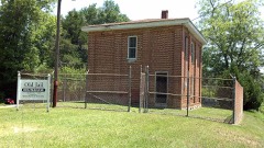 | Crawford County Jail | 7.0 miles | 1989 |
 | The Georgia Post Building | 7.0 miles | 2013 |
| National Archives record | The nomination case file for reference 11000790 in Record Group 79. |
| Crawford County | All 6 listed properties in this county. |