 Block
From the record
9 National Register listings published here, 1 of them a National Historic Landmark.
Sources: the National Register database, National Park Service
43 topographic sheets cover 26 settlements here, and 9 properties are on the National Register of Historic Places.
9 National Register listings published here, 1 of them a National Historic Landmark.
Sources: the National Register database, National Park Service
Every property in this county listed on the National Register of Historic Places, with the year it was listed and the federal nomination document.
| Photograph | Property | Type | Listed | Reference |
|---|---|---|---|---|
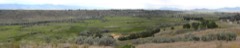 | Bear River Battleground | site | 1973 | 73000685 |
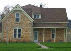 | Matthias Cowley House | building | 1976 | 76000673 |
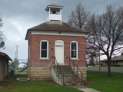 | Franklin City Hall | building | 1991 | 91001716 |
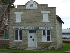 | Franklin Co-operative Mercantile Institution | building | 1991 | 91001717 |
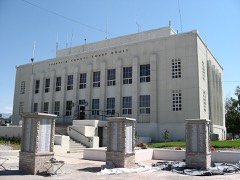 | Franklin County Courthouse | building | 1987 | 87001585 |
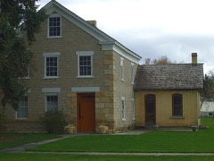 | L. H. Hatch House | building | 1973 | 73000684 |
 | Oneida Stake Academy | building | 1975 | 75000630 |
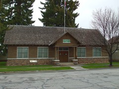 | Relic Hall | building | 2001 | 00001627 |
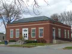 | US Post Office-Preston Main | building | 1989 | 89000135 |
Every wildfire the federal occurrence database records inside this county: 116 of them, burning about 30,918 acres. 57 started naturally and none was recorded as arson. Each settlement page carries the fires within five miles of it.
| Reported cause | Fires |
|---|---|
| Natural | 57 |
| Recreation and ceremony | 26 |
| Missing data/not specified/undetermined | 17 |
| Equipment and vehicle use | 8 |
| Debris and open burning | 3 |
| Power generation/transmission/distribution | 2 |
| Smoking | 1 |
| Fireworks | 1 |
| Railroad operations and maintenance | 1 |
The five largest, by the area the report gives. None of them was recorded as arson.
| Date | Cause | Size | Reported by | Name on the report |
|---|---|---|---|---|
| 11 August 2007 | Missing data/not specified/undetermined | 13,784 acres | Idaho Falls District | CLEVELAND |
| 10 August 2007 | Missing data/not specified/undetermined | 2,485 acres | Idaho Falls District | CLEVELAND HILL |
| 23 August 2016 | Missing data/not specified/undetermined | 2,413 acres | Caribou-Targhee National Forest | CLIFTON |
| 18 August 2000 | Missing data/not specified/undetermined | 1,163 acres | Caribou-Targhee National Forest | DRY CANYON |
| 4 August 2016 | Missing data/not specified/undetermined | 950 acres | Idaho Falls District | ROCKY PEAK |
| 19 September 2018 | Missing data/not specified/undetermined | 911 acres | Idaho Falls District | ONEIDA |
| 16 July 1994 | Equipment and vehicle use | 900 acres | Idaho Falls District | TWIN LAKES |
| 21 September 2001 | Power generation/transmission/distribution | 782 acres | Idaho Falls District | ONEIDA |
Every settlement page carries the fires within five miles of it - see the settlement index below.
The NOAA Storm Events Database holds 49 reports for this county, causing no deaths, 1 injury and about $1,905,850 in recorded property damage. Each settlement page carries the reports that name it.
| Kind of event | Reports |
|---|---|
| Thunderstorm Wind | 18 |
| Hail | 17 |
| Tornado | 4 |
| Flash Flood | 4 |
| Flood | 3 |
| Lightning | 1 |
| Funnel Cloud | 1 |
| Debris Flow | 1 |
The most serious of them, by death, then injury, then recorded damage. The accounts are quoted exactly as the forecast office filed them.
| When | Event | Place named | Harm | What the report says |
|---|---|---|---|---|
| August 2003 | Lightning | Whitney | 1 hurt | Lightning struck a house in the town of Whitney. The bolt caused a man at a doorway to be thrown several feet outdoors, after which the house exploded. Damage amounts were not available. |
| February 2017 | Flood | Thatcher | $1,720,000 | A major warmup beginning early in the month created extensive snow melt from record winter snows and massive sheet flooding. Many homes received extensive damage but the main problem in the county was extensive road damage. Many roads and bridges washed out and had to be closed. Many culverts also washed out and 28 were determined to be in need of major repair. Flooding to wells and septic systems in personal homes caused contamination of water in many cases. The state of Idaho declared Franklin County a disaster area. |
| March 2017 | Flood | Thatcher | $77,000 | Sheet flooding from snow melt continued in March but the effects decreased substantially from February. Road damage persisted along with some minor property damage. |
| August 2017 | Flash Flood | Fairview | $25,000 | Heavy rains caused flash flooding in Fairview in Franklin County. Several residents of Fairview reported flooding in their homes with 128 homes also without power for 3 to 4 hours. Power was restored at 7:30 pm MDT. |
| May 1986 | Tornado (F1) | not stated | $25,000 | no account filed |
| April 2023 | Debris Flow | Preston | $10,000 | At approximately 6:30 pm MDT on the 11th a mud slide necessitated the closure of SH-36 between Ovid and Preston. Continued warming temperatures resulted in two more slides in the area. As of 2:30 pm MDT on the 12th the highway remained closed north of Mink Creek. |
| June 2015 | Thunderstorm Wind | Clifton | $10,000 | Between 4:30 and 6:30 on 6/1/2015 the Franklin County Sheriff's Office received several reports of power lines down with either broken power poles or trees fallen on lines, or power poles and lines fallen on houses. Rocky Mountain Power and Utah Power are still working on restoring power, however, many residents are still without power. Much of the damage was isolated to the West Side of Franklin County. We had one report of a man electrocuted by a downed line, however, he was treated on scene by EMS and released. We had many trees blocking roads which have now been removed, and other reports of property damage due to wind including one cargo trailer which was blown over. We appreciate the help from the Preston Police Department, Franklin County Fire, EMS, Search & Rescue and Road & Bridge, Idaho State Police and Idaho State Fish & Game who all helped cover different calls. |
| March 2006 | Thunderstorm Wind | Central Portion | $10,000 | no account filed |
| August 2024 | Thunderstorm Wind | Franklin | $6,000 | Several trees and large tree limbs snapped and down in Franklin reported via social media. |
| May 1995 | Tornado | not stated | $5,000 | In Station Creek a tornado moved through destorying barns, campers and farming equipment. Winds in excess of 100 mph were reported. The tornado lasted 20 minutes. |
| May 1995 | Tornado | Station Creek | $5,000 | In Station Creek a tornado moved through destorying barns, campers and farming equipment. Winds in excess of 100 mph were reported. The tornado lasted 20 minutes. |
| May 1995 | Thunderstorm Wind | Nyssa | $5,000 | In Station Creek a tornado moved through destorying barns, campers and farming equipment. Winds in excess of 100 mph were reported. The tornado lasted 20 minutes. |
| June 2015 | Thunderstorm Wind | Clifton | $3,000 | Power lines reported downed over houses and roads with 4 to 6 inch trees downed as well near Clifton. |
| June 2003 | Thunderstorm Wind | Weston | $2,000 | Strong microburst winds knocked trees and power lines down in Weston, Idaho. |
| August 1998 | Hail | Preston | $2,000 | no account filed |
| August 2018 | Hail | Clifton | $400 | Ping pong ball sized hail reported in the town of Clifton. Some damage to siding reported on homes. |
| June 1982 | Tornado (F1) | not stated | $250 | no account filed |
| July 2017 | Hail | Preston | $200 | One inch hail fell in Preston with reports of window of car broken out on South First Street by it. |
| August 2025 | Thunderstorm Wind | Franklin | - | Mesonet station 8433 D5 Franklin on US-91 recorded a 59 mph thunderstorm outflow wind. |
| August 2024 | Thunderstorm Wind | Whitney | - | The Cub River mesonet site measured a 62 mph wind gust. |
| June 2023 | Flash Flood | Banida | - | Water was running over US Highway 91 near Banida. |
| July 2023 | Thunderstorm Wind | Mink Creek | - | The Treasureton Summit ITD site recorded 58 mph wind gust. |
| August 2018 | Hail | Franklin | - | One inch hail in the town of Franklin. |
| August 2018 | Hail | Weston | - | One inch hail reported in Weston. |
| August 2018 | Hail | Oxford | - | One inch hail in Oxford. |
| August 2018 | Hail | Banida | - | Quarter sized hail at the Treasureton Reservoir. |
| January 2017 | Flood | Preston | - | Some flooding in the NE corner of Preston, especially around the Country Club/golf course. Water over the road on Highway 34 in Preston. Also, water reported over the road on Highway 36 up to Mile Marker 7. Water has not been deep enough to necessitate road closures. |
| July 2017 | Flash Flood | Preston | - | Over 1 foot of water was covering South First Street East in Preston after over a half inch of rain fell in 10 minutes. |
| June 2015 | Hail | Preston | - | One inch hail reported near the city of Preston. |
| August 2015 | Hail | Preston | - | One inch hail measured near Preston. |
| May 2015 | Funnel Cloud | Preston | - | Funnel cloud viewed over Weston and Preston. |
| June 2010 | Thunderstorm Wind | Preston | - | Measured wind gust of 64 mph. |
| August 2010 | Thunderstorm Wind | Preston | - | Preston mesonet site reported sixty-four mph wind gust. |
| June 2009 | Flash Flood | Dayton | - | Flooding reported near Weston with roads flooded. |
| May 1995 | Hail | Soda Springs | - | In Station Creek a tornado moved through destorying barns, campers and farming equipment. Winds in excess of 100 mph were reported. The tornado lasted 20 minutes. |
| May 1995 | Hail | Dover | - | In Station Creek a tornado moved through destorying barns, campers and farming equipment. Winds in excess of 100 mph were reported. The tornado lasted 20 minutes. |
| May 1995 | Hail | Sylvania | - | In Station Creek a tornado moved through destorying barns, campers and farming equipment. Winds in excess of 100 mph were reported. The tornado lasted 20 minutes. |
| March 2006 | Thunderstorm Wind | Preston | - | no account filed |
| May 1996 | Thunderstorm Wind | Preston | - | no account filed |
| August 1991 | Hail | not stated | - | no account filed |
| July 1989 | Thunderstorm Wind | not stated | - | no account filed |
| August 1989 | Thunderstorm Wind | not stated | - | no account filed |
| September 1989 | Thunderstorm Wind | not stated | - | no account filed |
| July 1982 | Thunderstorm Wind | not stated | - | no account filed |
| May 1981 | Hail | not stated | - | no account filed |
| August 1975 | Thunderstorm Wind | not stated | - | no account filed |
| June 1962 | Hail | not stated | - | no account filed |
| June 1958 | Hail | not stated | - | no account filed |
| June 1958 | Hail | not stated | - | no account filed |
The Survey's mineral resources record lists 24 workings inside this county. 3 still produce and 21 are closed or unrecorded. Each settlement page carries the workings within five miles of it.
| Commodity | Workings |
|---|---|
| Manganese | 7 |
| Geothermal | 6 |
| Limestone, General | 4 |
| Sand and Gravel, Construction | 4 |
| Lead | 1 |
| Silver | 1 |
| Copper | 1 |
| Tungsten, Cobalt | 1 |
| Calcium | 1 |
The least common of them first, because a county's hundredth gravel pit says nothing its first ten did not.
| Where | Site | Commodity | Status | Recorded |
|---|---|---|---|---|
| Hatch Prospect | Copper, Tungsten, Cobalt | Prospect | ||
| Lucky Baker Prospect | Lead, Silver | Prospect | ||
| Treasure Canyon Mill #2 | Calcium | Producer | ||
| Clifton | Limestone, General | Past Producer | ||
| Clifton | Limestone, General | Past Producer | ||
| Franklin County Pit | Sand and Gravel, Construction | Producer | ||
| Gravel Pit | Sand and Gravel, Construction | Past Producer | ||
| Gravel Pit | Sand and Gravel, Construction | Past Producer | ||
| Gravel Pit | Sand and Gravel, Construction | Past Producer | ||
| Treasure Canyon Calcite | Limestone, General | Unknown | ||
| Treasure Canyon Quarry #2 | Limestone, General | Producer | ||
| Battle Creek Hot Spring | Geothermal | Occurrence | ||
| Geothermal Location | Geothermal | Occurrence | ||
| Geothermal Location No. 12s-40e-31d | Geothermal | Occurrence | ||
| Maple Grove Hot Spring | Geothermal | Occurrence | ||
| Vincent Hot Spring | Geothermal | Occurrence | ||
| Wayland Hot Spring | Geothermal | Occurrence | ||
| Cleveland Mine | Manganese | Past Producer | 1927 | |
| Hale Mine | Manganese | Unknown | ||
| Hot Spot Property | Manganese | Occurrence | Replacement | |
| Idaho Manganese Mining Company Mine | Manganese | Past Producer | 1922, 1925 | |
| Manganese Mine | Manganese | Unknown | ||
| Mc Gregor Property | Manganese | Occurrence | Replacement | |
| South Cleveland | Manganese | Prospect |
Named settlements recorded in the Geographic Names Information System, each with the topographic sheets covering it. Villages, hamlets and abandoned places alike. Each is shown with the nearest named watercourse or landform and the survey quadrangle it falls on.
Preston census division · 83237 · On Deep Creek · Mapleton quadrangle
15 sheets, 1915 to 2005
Mink Creek census division · 83283 · Near Mound Valley · Oneida Narrows Reservoir quadrangle
13 sheets, 1915 to 2005
Dayton census division · 83228 · On Clifton Creek · Clifton quadrangle
11 sheets, 1954 to 1984
Preston census division · 83237 · On Maple Creek · Franklin quadrangle
12 sheets, 1915 to 1983
Preston census division · 83263 · Near Self Help Hollow · Mink Creek quadrangle
14 sheets, 1915 to 2005
Preston census division · 83263 · On Sugar Creek · Mapleton quadrangle
15 sheets, 1915 to 2005
Mink Creek census division · 83263 · On Birch Creek · Mink Creek quadrangle
14 sheets, 1915 to 2005
Mink Creek census division · 83283 · On Williams Creek · Oneida Narrows Reservoir quadrangle
13 sheets, 1915 to 2005
Preston census division · 83237 · On Maple Creek · Franklin quadrangle
12 sheets, 1915 to 1983
Mink Creek census division · 83283 · Near Cleveland Hill · Oneida Narrows Reservoir quadrangle
13 sheets, 1915 to 2005
Mink Creek census division · 83263 · On Trout Creek · Thatcher quadrangle
14 sheets, 1915 to 2005