 Block
From the record
6 National Register listings published here.
Sources: the National Register database, National Park Service
37 topographic sheets cover 18 settlements here, and 6 properties are on the National Register of Historic Places.
6 National Register listings published here.
Sources: the National Register database, National Park Service
Every property in this county listed on the National Register of Historic Places, with the year it was listed and the federal nomination document.
| Photograph | Property | Type | Listed | Reference |
|---|---|---|---|---|
 | Belvidere High School | building | 1997 | 97000815 |
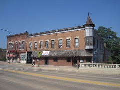 | Belvidere North State Street Historic District | district | 2012 | 12000324 |
 | Belvidere South State Street Historic District | district | 2012 | 12000325 |
 | Lampert-Wildflower House | building | 2005 | 05000870 |
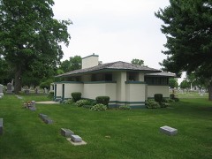 | Pettit Memorial Chapel | building | 1978 | 78001112 |
 | United States Post Office-Belvidere | building | 2000 | 00000473 |
Every wildfire the federal occurrence database records inside this county: 1 of them, burning about 2 acres. None started naturally and none was recorded as arson. Each settlement page carries the fires within five miles of it.
| Reported cause | Fires |
|---|---|
| Missing data/not specified/undetermined | 1 |
The five largest, by the area the report gives. None of them was recorded as arson.
| Date | Cause | Size | Reported by | Name on the report |
|---|---|---|---|---|
| 18 July 2012 | Missing data/not specified/undetermined | 2.0 acres | Illinois Division of Forestry Resources | ELICA |
Every settlement page carries the fires within five miles of it - see the settlement index below.
The NOAA Storm Events Database holds 267 reports for this county, causing 26 deaths, 454 injuries and about $8,258,000 in recorded property damage. Each settlement page carries the reports that name it.
| Kind of event | Reports |
|---|---|
| Thunderstorm Wind | 139 |
| Hail | 65 |
| Tornado | 25 |
| Flood | 16 |
| Flash Flood | 14 |
| Heavy Rain | 5 |
| Lightning | 2 |
| Funnel Cloud | 1 |
The most serious of them, by death, then injury, then recorded damage. The accounts are quoted exactly as the forecast office filed them.
| When | Event | Place named | Harm | What the report says |
|---|---|---|---|---|
| April 1967 | Tornado (F4) | not stated | 24 killed, 410 hurt, $250,000 | no account filed |
| March 2023 | Tornado (EF1) | Irene | 1 killed, 40 hurt | This tornado crossed into Boone County south of Cherry Valley from Winnebago County. The tornado, which originated in Ogle County, traversed northeastward doing minor damage to farms. As it moved through the town of Belvidere, the storm produced multiple instances of damage to businesses, homes, and trees. Included in this is the partial roof collapse of the Apollo Theatre downtown which resulted in one fatality and 40 injuries. From there, the tornado would travel another 7 miles doing additional damage to trees before lifting near Orth Rd just west of the Boone-McHenry county line. |
| August 2001 | Lightning | Capron | 1 killed | no account filed |
| January 2008 | Tornado (EF3) | Poplar Grove | 4 hurt, $2,000,000 | A tornado touched down at 330 pm CST about 1.2 miles north of Poplar Grove in Boone County and ended at 348 pm about 3.2 miles north northeast of Harvard in McHenry County. The tornado crossed the Boone McHenry County line near Hunter Road, about 3 miles northeast of Capron. The first signs of damage were at Quail Trap Road just east of Poplar Grove Road where trees were damaged and sections of roofing were removed from a shed. The tornado intensified to EF2 intensity at Edwards Apple Orchard on Centerville Road. A large barn was destroyed and other buildings were severely damaged. Large trees were snapped or uprooted. The tornado reached its maximum intensity of EF3 at the northeast corner of Centerville Road and Beaverton Road. A two story farm house and garage were leveled and large trees were stripped of all branches. The tornado was about 100 yards wide through this area. The tornado continued east northeast across Stimes Road and eventually crossed the Boone McHenry County line near Hunter Road. Most of the damage through this part of the tornado path was EF1, though it weakened to EF0 near the county line. There was damage to trees, power lines, barns and sheds. A few farm houses had shingles or small sections of roof damaged. Four injuries were reported. |
| November 2010 | Tornado (EF2) | Argyle | $4,500,000 | A tornado which touched down in eastern Winnebago County, crossed into western Boone County and moved across largely open rural fields towards the town of Caledonia. Significant damage occurred to at least six buildings in Caledonia, with approximately 20 additional buildings sustaining minor damage. Several large trees were snapped or uprooted, and a grain bin partially collapsed. The tornado was again likely at EF2 intensity at this time. The tornado then continued northeast from Caledonia, downing several power poles and causing damage ranging from blown off roofs to completely destroying at least three farm outbuildings. One of these buildings, located two miles northwest of Capron, had also been damaged during the January 2008 tornado. The tornado then crossed into McHenry County. |
| August 2006 | Thunderstorm Wind | Belvidere | $400,000 | Huge trees and 40 to 50 power lines blown down. A roof was blown off a house and a semi trailer was blown over. |
| April 2014 | Hail | Belvidere | $250,000 | Hail to two inches in diameter was estimated on Route 76 near Poplar Grove Airport. Shopping centers in the area reported heavy damage from hail. A Walmart had 129 skylights damaged or broken while a ShopKo was also damaged by the hail. |
| April 2015 | Tornado (EF1) | Herbert | $150,000 | Witnesses said the tornado touched down in a field then moved northeast destroying a detached garage. The tornado ripped the roof off of a home though the walls mainly remained intact. Several hardwood trees were snapped. Maximum wind speeds were estimated to be 110 mph. (Tornado 6 of 7). |
| May 2017 | Tornado (EF1) | Belvidere Arpt | $100,000 | A tornado touched down approximately two miles south of Poplar Grove. Tree branches were broken on Poplar Grove Road where the tornado touched down. A large softwood tree trunk was snapped on Beaver Road. Trees were debarked on Beaverton Road. A small outbuilding was destroyed on Edson Road. Hardwood trees were snapped at the trunk on Russellville Road and again on Capron Road. On the east side of Capron, A garage was destroyed and shingles were peeled off the north side of a home and dozens of trees were snapped. Another small outbuilding was destroyed on County Line Road with debris strewn about three quarters of a mile downstream. The tornado passed into McHenry County on County Line Road south of Hunter Road. |
| June 2017 | Flash Flood | Hunter | $100,000 | Very heavy rain fell across Boone County during the evening hours of June 28th. Numerous roads were flooded, closed and impassable due to flash flooding. Many county roads were also flooded and closed. Significant flooding was reported on many roads in Belvidere where there were water rescues from stranded vehicles. Ditches were overflowing onto Genoa Road. Storm total rainfall reports included 4.95 inches 2 miles northwest of Belvidere and 4.70 inches in Belvidere. |
| August 2007 | Flash Flood | Belvidere | $100,000 | Several roads and many basements were flooded after 4 to 6 inches of rain fell over southern Boone County in a short period of time. Motorists flooded on Appleton Road near Route 20. |
| April 2015 | Tornado (EF1) | Irene | $75,000 | This is a continuation of a tornado that began in Dekalb County. This tornado was identified from a storm chaser video and survey. Three barns were destroyed on Pearl Street Road. Maximum winds speeds were estimated to be 110 mph. (Tornado 4b of 7). |
| July 2011 | Thunderstorm Wind | Poplar Grove | $45,000 | Over 30 large trees were reported down in the Poplar Grove and Candlewick Lake area, including one tree that fell onto a house on Bounty Drive in Candlewick Lake and a tree that fell onto a car in Poplar Grove. Also in Poplar Grove, a roof was blown off of a house and a garage was destroyed. |
| July 2011 | Thunderstorm Wind | Poplar Grove | $25,000 | A roof was blown off of a house and a garage was destroyed. |
| July 2011 | Thunderstorm Wind | Belvidere | $25,000 | Numerous trees fell across Belvidere causing damage to powerlines and roofs. One tree fell against a house on Garden Drive while another fell onto a roof on East Lincoln Avenue. |
| June 2008 | Tornado (EF1) | Irene | $25,000 | A tornado touched down southwest of the intersection of Bloods Point Road and Stone Quarry Road. The tornado snapped and uprooted trees and damaged or destroyed farm buildings. The tornado moved northeast and crossed Pearl Street where a hay barn collapsed and a large grain bin was damaged. The tornado passed over Route 4 near Huber Road then finally lifted southwest of Interstate 90 near Fruit Farm Road. |
| August 2006 | Thunderstorm Wind | Capron | $25,000 | Trees and tree limbs were blown down. A house and a truck were damaged in Capron. |
| April 1991 | Tornado (F0) | not stated | $25,000 | no account filed |
| June 1984 | Tornado (F1) | not stated | $25,000 | no account filed |
| September 1959 | Tornado (F1) | not stated | $25,000 | no account filed |
| July 2016 | Flash Flood | Belvidere | $24,000 | Multiple roads flooded and closed on the south side of town. Belvidere Police Department had to replace a police car damaged by flood waters. |
| April 2015 | Tornado (EF0) | Belvidere | $20,000 | This was a satellite tornado that formed from the same storm that formed the long tracked EF-4 tornado. A small zoo was heavily damaged with walls collapsed on several outbuildings and small barns. Three animals were killed. Softwood trees 4 to 6 inches in diameter were snapped. The estimated peak wind was 85 mph. (Tornado 5 of 7). |
| July 2013 | Thunderstorm Wind | Caledonia | $20,000 | Several large trees fell onto three homes in Candlewick Lake Subdivision near Poplar Grove. A large tree fell down blocking Route 173 in Poplar Grove. |
| June 2007 | Thunderstorm Wind | Garden Prairie | $10,000 | Several trees blown down, up to 4 feet in diameter. Powerlines blown down and minor structural damage to some houses. |
| June 2007 | Flash Flood | Poplar Grove | $10,000 | Whiting Road washed out, just west of Popular Grove. |
| July 2003 | Thunderstorm Wind | Belvidere | $6,000 | no account filed |
| June 2014 | Thunderstorm Wind | Caledonia | $5,000 | Roof shingles were ripped off near Route 173 and Caledonia Road. |
| September 2012 | Thunderstorm Wind | Belvidere | $5,000 | Windows were blown out of a building. |
| July 2008 | Lightning | Belvidere | $5,000 | Lightning struck a home on Ruth Circle but only caused damage to cables and appliances, no fire or structural damage was reported. |
| May 1986 | Tornado (F0) | not stated | $2,500 | no account filed |
| August 2016 | Flash Flood | Belvidere | $2,000 | Car stalled in deep water and other flooded roads around town. |
| July 2008 | Thunderstorm Wind | Belvidere | $1,000 | Trees and power lines were blown down. |
| June 1995 | Thunderstorm Wind | Belvidere | $1,000 | Trees and limbs were blown down, knocking out power. |
| July 1995 | Thunderstorm Wind | Belvidere | $1,000 | Windows were blown in at the Belvidere Oasis over the Interstate 90 tollway. |
| June 2010 | Thunderstorm Wind | Belvidere | $500 | An aluminum flag pole was blown down and a six inch diameter tree was blown down. |
| April 2026 | Thunderstorm Wind | Poplar Grove | - | A tree was downed along Poplar Grove Rd south of Poplar Grove. |
| April 2026 | Funnel Cloud | Capron | - | McHenry County emergency management reported a funnel cloud near Capron. |
| April 2026 | Heavy Rain | Timberlane | - | A personal weather station recorded 1.81 inches of rainfall near Timberlane between 6:00 and 7:00 PM CST. |
| June 2025 | Thunderstorm Wind | Belvidere | - | Extensive tree damage was reported along Distillery Rd outside of Belvidere. One tree trunk was snapped a few feet off the ground and multiple large tree limbs were downed, some of them onto power lines. |
| June 2025 | Tornado (EF0) | Belvidere | - | A brief EF0 tornado with peak estimated winds of 85 mph touched down northwest of Belvidere. Photos shared by the Boone County EMA show that a concentrated area of tree damage occurred at and across the street from a property along Distillery Road south of US Rt. 20. Multiple trees were uprooted or snapped, and several large tree limbs and branches were downed as well, including some that fell onto powerlines. |
| June 2025 | Heavy Rain | Hunter | - | A private weather station recorded 3.91 of storm total rain through 6 PM. 1.12 were recorded in a 30-minute period. |
| August 2025 | Heavy Rain | Blaine | - | A private weather station recorded 5.75 of rain through 7 PM CST, most of which would have fallen since 5:30 PM CST. |
| July 2025 | Thunderstorm Wind | Garden Prairie | - | A tree was blown down on Mill Street Road and Garden Prairie Road. |
| August 2025 | Thunderstorm Wind | Belvidere | - | Trees 3 to 4 feet in diameter were snapped along N Appleton Rd between Douglas and Maryland courts in Belvidere. |
| August 2025 | Thunderstorm Wind | Belvidere | - | Boone County EM reported numerous trees down on the southeast side of Belvidere. |
| August 2025 | Thunderstorm Wind | Belvidere | - | Two trees two feet in diameter were downed and branches 6 to 12 inches in diameter were broken near Gardner and Jackson streets in Belvidere. |
| August 2025 | Thunderstorm Wind | Belvidere | - | Seven trees were downed on the corner of 2nd St and Whitney Blvd, the largest being about 4 feet in diameter. Power lines were also reported down. |
| July 2024 | Thunderstorm Wind | Poplar Grove Airport | - | Several large tree limbs were blown down and one large tree was uprooted in and near the Henninger Heights subdivision northeast of Belvidere. |
| May 2024 | Tornado (EF0) | Blaine | - | A weak tornado touched down just west of Beaverton Road, about halfway between Hunter Road and Blaine Road. The tornado moved northeast producing sporadic tree damage in Boone County and crossed into McHenry County just north of Engelhardt Road. |
| July 2024 | Flood | Belvidere | - | Street flooding was reported in Belvidere. |
| June 2024 | Heavy Rain | Belvidere | - | A 24 hour rainfall of 3.8 was recorded in Belvidere. |
| July 2024 | Flash Flood | Timberlane | - | A 50 foot wide stream of water about 3 to 4 inches deep was rushing across Squaw Prairie Road between Townhall Road and Beloit Road. Piscasaw Creek overtopped the Squaw Prairie Road Bridge. Photos and videos showed flooded yards, driveways and roads in the adjacent Wilcox subdivision. Several roads and fields were flooded northeast of Belvidere and north of Garden Prairie. Some roads had several inches of standing water on them and were closed. |
| July 2024 | Flood | Belvidere | - | Two to three inches of water caused lane blockage on Logan Avenue from East Avenue to Jamestown Avenue. |
| March 2023 | Tornado (EF1) | Caledonia | - | This tornado touched down southwest of the village of Caledonia moving through mostly farmland along its northeastward track. The storm destroyed numerous outbuildings, heavily damaged a silo, and caused a grain bin to collapse. In the Candlewick Lake neighborhood southeast of Caledonia, a few homes sustained roof and siding damage. Several trees were also damaged. The tornado then crossed into the village of Sharon in southwestern Walworth County, Wisconsin. The storm would go on for nearly another four miles mostly doing damage to barns and trees before lifting near Town Hall Rd and Chilson Rd. |
| April 2023 | Thunderstorm Wind | Poplar Grove Airport | - | A private weather station measured a wind gust to 85 mph. Several large trees were uprooted or damaged, fascia was peeled off of houses and a shed was blown off its foundation. |
| June 2023 | Hail | Belvidere | - | Multiple quarter size hail reports were received from Belvidere. |
| July 2023 | Tornado (EF0) | Argyle | - | An EF-0 tornado dropped on the northeast side of Orth and Argyle Roads along the Winnebago and Boone County line. The tornado then tracked east-northeast before lifting in a farm field east of Beloit Road between Dawson Lake and Orth Roads. Damage along the path of the tornado consisted of snapped and uprooted trees, in addition to minor roofing damage. |
| August 2023 | Thunderstorm Wind | Poplar Grove | - | A photo shared on social media showed half of a small tree snapped. |
| August 2023 | Thunderstorm Wind | Candlewick Lake | - | Several trees were blown down along the Long Prairie Trail. |
| July 2023 | Thunderstorm Wind | Belvidere | - | Broken power poles and tree limbs up to 3 inches in diameter were reported broken in Belvidere via mPING. |
The Survey's mineral resources record lists 17 workings inside this county. 6 still produce and 11 are closed or unrecorded. Each settlement page carries the workings within five miles of it.
| Commodity | Workings |
|---|---|
| Sand and Gravel, Construction | 9 |
| Stone, Crushed/Broken | 8 |
The least common of them first, because a county's hundredth gravel pit says nothing its first ten did not.
| Where | Site | Commodity | Status | Recorded |
|---|---|---|---|---|
| Belvidere Crushed Stone Quarry | Stone, Crushed/Broken | Past Producer | ||
| Belvidere Quarry | Stone, Crushed/Broken | Past Producer | ||
| Boone City Hwy Dept | Stone, Crushed/Broken | Past Producer | ||
| Irene Quarry & Mill #3 | Stone, Crushed/Broken | Producer | ||
| J. Vowles Quarry | Stone, Crushed/Broken | Past Producer | ||
| Lee Quarry | Stone, Crushed/Broken | Producer | ||
| Schlichting Excavating Quarry | Stone, Crushed/Broken | Producer | ||
| Thebes Limestone Mine Quarry | Stone, Crushed/Broken | Past Producer | ||
| Belvidere Dredge | Sand and Gravel, Construction | Producer | ||
| Belvidere Pit | Sand and Gravel, Construction | Past Producer | ||
| Belvidere Sand & Stone Co. Quarry | Sand and Gravel, Construction | Producer | ||
| Cordray Brothers Pit | Sand and Gravel, Construction | Producer | ||
| Mchenry Pit | Sand and Gravel, Construction | Past Producer | ||
| Meyer Pit | Sand and Gravel, Construction | Past Producer | ||
| Spencer Pit | Sand and Gravel, Construction | Past Producer | ||
| Spots Pit | Sand and Gravel, Construction | Past Producer | ||
| Tripps Pit | Sand and Gravel, Construction | Past Producer |
Named settlements recorded in the Geographic Names Information System, each with the topographic sheets covering it. Villages, hamlets and abandoned places alike. Each is shown with the nearest named watercourse or landform and the survey quadrangle it falls on.
Poplar Grove township · 61065 · Belvidere NE quadrangle
12 sheets, 1918 to 1981
Belvidere township · 61008 · On Piscasaw Creek · Belvidere North quadrangle
14 sheets, 1918 to 1981
Belvidere township · 61016 · On Beaver Creek · Cherry Valley quadrangle
15 sheets, 1918 to 1981
Bonus township · 61038 · On Mud Creek · Garden Prairie quadrangle
14 sheets, 1932 to 1981
Caledonia township · 61011 · Caledonia quadrangle
14 sheets, 1918 to 1993
No longer a settlement
Belvidere township · 61008 · On Beaver Creek · Cherry Valley quadrangle
15 sheets, 1918 to 1981
Spring township · 61008 · Belvidere South quadrangle
15 sheets, 1918 to 1981
No longer a settlement
The vanished settlements of Boone County: the places named above that are no longer on the map.