 Block
From the record
4 National Register listings published here.
Sources: the National Register database, National Park Service
52 topographic sheets cover 16 settlements here, and 4 properties are on the National Register of Historic Places.
4 National Register listings published here.
Sources: the National Register database, National Park Service
Every property in this county listed on the National Register of Historic Places, with the year it was listed and the federal nomination document.
| Photograph | Property | Type | Listed | Reference |
|---|---|---|---|---|
 | Illinois Central Railroad Depot | building | 1999 | 99000978 |
 | Mound City Civil War Naval Hospital | building | 1974 | 74002285 |
 | Mound City National Cemetery | site | 1997 | 97001174 |
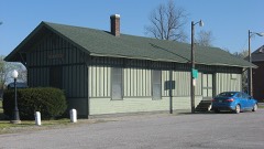 | Olmstead Depot | building | 1989 | 89002101 |
Every wildfire the federal occurrence database records inside this county: 14 of them, burning about 137 acres. None started naturally and 2 were recorded as arson. Each settlement page carries the fires within five miles of it.
| Reported cause | Fires |
|---|---|
| Missing data/not specified/undetermined | 10 |
| Equipment and vehicle use | 2 |
| Arson/incendiarism | 2 |
The five largest, by the area the report gives. Two of them were set deliberately.
| Date | Cause | Size | Reported by | Name on the report |
|---|---|---|---|---|
| 6 March 2010 | Missing data/not specified/undetermined | 36 acres | Cypress Creek National Wildlife Refuge | CHAPEL |
| 8 November 2010 | Missing data/not specified/undetermined | 27 acres | Cypress Creek National Wildlife Refuge | CACHE CHAPEL |
| 1 February 1993 | Equipment and vehicle use | 25 acres | Shawnee National Forest | not named |
| 24 March 2009 | Missing data/not specified/undetermined | 16 acres | Illinois Division of Forestry Resources | CACHE |
| 1 August 2007 | Arson/incendiarism | 9.7 acres | Illinois Division of Forestry Resources | not named |
| 1 August 2007 | Arson/incendiarism | 8.6 acres | Illinois Division of Forestry Resources | not named |
| 28 February 2006 | Equipment and vehicle use | 5.0 acres | Cypress Creek National Wildlife Refuge | CACHE CHAPEL ROAD |
| 11 November 2010 | Missing data/not specified/undetermined | 4.0 acres | Cypress Creek National Wildlife Refuge | NORMANDY |
Every settlement page carries the fires within five miles of it - see the settlement index below.
The NOAA Storm Events Database holds 245 reports for this county, causing 3 deaths, 16 injuries and about $8,251,000 in recorded property damage. Each settlement page carries the reports that name it.
| Kind of event | Reports |
|---|---|
| Flood | 79 |
| Thunderstorm Wind | 78 |
| Hail | 54 |
| Flash Flood | 14 |
| Tornado | 12 |
| Funnel Cloud | 6 |
| Heavy Rain | 2 |
The most serious of them, by death, then injury, then recorded damage. The accounts are quoted exactly as the forecast office filed them.
| When | Event | Place named | Harm | What the report says |
|---|---|---|---|---|
| May 2003 | Tornado (F4) | Grand Chain | 1 killed, 13 hurt, $3,500,000 | This violent tornado began near Grand Chain and reached its maximum intensity of 210 MPH as it neared the Massac County line. A 53-year-old man was killed when the chimney of his house collapsed on him. The man, who was in his basement, was protecting his son by lying on top of him when the collapse occurred. The son received broken bones. Their house was impaled by some nearby large trees that prevented it from being swept farther away. Along the Pulaski County portion of the tornado path, six single family homes and ten mobile homes were destroyed. Another ten single family homes and a mobile home had major damage. A few dozen other residences received some type of minor damage. A few dozen outbuildings, two businesses, and a campground were destroyed or had major damage. Approximately 13 persons were injured, but only a few of those required hospitalization. All roads in the damage area were impassable due to large numbers of trees and building debris on them. Many of the tornado victims in this county had no insurance on their residences. The area of most intense destruction was along Tick Ridge Road, a state road that follows a ridge above the Ohio River. |
| June 2019 | Thunderstorm Wind | Ullin | 1 killed, 1 hurt, $20,000 | Damaging winds crossed parts of Pulaski County, downing numerous trees. A 48-year-old woman was killed when a tree fell onto her car as she was driving on Old U.S. Highway 51 about two miles south of Ullin. At Mounds, a teenage girl was seriously injured when a tree fell on her in a city park. |
| January 2015 | Flood | Pulaski | 1 killed, $40,000 | One fatality occurred when a motorist drove around barricades into a flooded area along Sandusky Road. The area is fairly prone to flooding of the Cache River. The vehicle was found completely submerged in Cache River floodwaters. A volunteer fire and rescue squad located the vehicle and the body of the motorist. The body of the female motorist was found in a flooded field about 100 feet from the vehicle. It appeared she may have tried to turn around, and the vehicle ended up in a flooded ditch. The incident was reported by a tow-truck driver who towed a second vehicle out of the floodwater. The driver of the second vehicle got out safely, but the vehicle was almost completely submerged except for a small part of the top. |
| April 1972 | Tornado (F2) | not stated | 2 hurt, $25,000 | no account filed |
| March 2008 | Flood | Ullin | $2,500,000 | Ullin was especially hard hit. At least 50 homes in Ullin were flooded, along with the town's pump station. The town's post office and grocery store were flooded. A car was submerged up to the steering wheel. Floodwaters rushed over a bridge in Ullin. Two to three bridges were washed out. Dozens of residents of an assisted living facility were evacuated as water entered the facility. The facility sustained major damage. Flooding of the Cache River closed Shawnee College Road for several days. Most of the county back roads were closed, and other areas of the county outside Ullin were evacuated. Six apartments and two houses were flooded in Mound City. Several homes in Karnak were surrounded with water or sandbagged, mainly due to flooding of the Cache River. Portions of Route 37 and U.S. Highway 51 were closed. |
| April 1957 | Tornado (F2) | not stated | $250,000 | no account filed |
| May 2011 | Flood | Mound City | $200,000 | Major flooding continued on the Ohio River from April. At the Grand Chain river gage, the flood crest of 62.20 feet on the evening of May 2 came within two feet of the record of 64.00 feet set in 1937. The activation of the New Madrid Floodway by the U.S. Army Corps of Engineers spared Pulaski County from an even higher crest. With the detonation of the Mississippi River levee at Birds Point, Missouri, the Ohio River dropped suddenly at Grand Chain. |
| July 2023 | Flash Flood | Mound City | $150,000 | no account filed |
| March 2018 | Flood | Olmsted | $100,000 | Major flooding continued on the Ohio River from late February. At the Grand Chain river gage, the river crested on March 2 at 57.3 feet. This was the fifth highest stage on record, and it was exactly one-half foot below the flood crest of March, 1997. Flood stage is 42 feet. Numerous county roads were closed near the river. Widespread flooding of low-lying farmland occurred. Most of the farmland was still unplanted. |
| June 2009 | Thunderstorm Wind | Ullin | $100,000 | Part of the roof was blown off a school gymnasium, with some damage to at least one wall. Rainwater further damaged the gym floor. The roof of a bus garage behind the gym was damaged. Large tree limbs were down, and playground equipment was blown around. A large metal light pole was blown down. |
| January 2008 | Thunderstorm Wind | Ullin | $100,000 | Numerous trees were blown down across the county, especially from Ullin north. The roof was partially blown off a high school just east of Ullin. In Mound City, trees penetrated the roofs of two homes. A roof was damaged in Olmsted. Several vehicles were damaged by falling trees around the county. |
| March 2006 | Thunderstorm Wind | Ullin | $100,000 | A continuous path of damage began near the Ullin exit of Interstate 57, which is exit 18. The damage swath was about one mile wide and extended eastward to the Massac County border. Dozens of trees were snapped or uprooted. Near Ullin, a gas station canopy was blown down, and the gas station sustained roof damage. Debris was blown over 100 yards from the gas station. The metal roof was torn off a barbeque stand and blown to Interstate 57. At a car dealership near Ullin, several cars were moved, and one camper was pushed into a ditch. A pickup truck with an attached camper was reportedly overturned at a local motel. A grain silo was blown in, and its roof was blown 100 yards away. A carport and a barn were destroyed. Peak winds were estimated near 90 MPH. |
| June 1995 | Thunderstorm Wind | Countywide | $100,000 | Numerous trees and power lines were downed, making some roads impassable. A few of the hardest hit communities were Karnak, Olmsted, and Mounds. Winds at these places were estimated by weather service employees to have been around 80 mph. Many homes were damaged by falling trees. A couple of house roofs were blown off in Mounds and four miles north of Olmsted. A truck was blown off the road just south of Mounds. Power was out for days in the hardest hit areas. |
| March 2011 | Flood | Olmsted | $100,000 | no account filed |
| February 2011 | Flash Flood | Grand Chain | $70,000 | Two bridges were washed out. One of the bridges was on a main street in Olmsted, and the other was on a secondary road. Three to four inches of water covered State Route 37 at the Johnson County line. Warning signs were posted to alert motorists. Water was over a couple of other roads in the Olmsted and Grand Chain areas. A spotter reported storm-total rainfall of about three inches, of which two inches fell in the past twelve hours. |
| January 2005 | Tornado (F1) | Pulaski | $70,000 | A grain bin was blown over, and about a half dozen sheds and outbuildings were damaged or destroyed. Numerous trees and large limbs were blown down. An older mobile home was destroyed 3 to 4 miles west of Grand Chain. Peak winds were estimated near 75 MPH. Structural damage was minimal due to the very rural nature of the area. |
| March 2025 | Tornado (EF1) | Pulaski | $50,000 | An EF-1 tornado began near the Mississippi River just northwest of Fayville in Alexander County and moved east northeast into Pulaski County just northeast of Sandusky. The tornado uprooted and snapped the trunks of numerous trees along its path. A few buildings sustained roof damage. The estimated peak wind was 105 mph. The total path length of the tornado was around 18 miles. A large area of 70-90 mph straight line winds swept just south of the tornado and eventually overtook it as it moved east of Interstate 57. Damage indicative of the 70-90 mph straight line winds continued sporadically into western Massac County. |
| January 2016 | Flood | Olmsted | $50,000 | Major flooding of the Ohio River continued into January. At the Grand Chain river gage, the river crested at 55.4 feet on the 3rd. Flood stage there is 42 feet. This flood was very similar to the flood of May, 1995, when the crest was 55.1 feet. Flood stage there is 42 feet. There was widespread flooding of low-lying fields, and a number of secondary roads were flooded. |
| May 2011 | Tornado (EF1) | Mound City | $50,000 | The tornado moved northeast across Mound City, where much of the damage occurred. One small mobile home was picked up and thrown into a power pole. There was roof damage to several homes, mainly shingles. Numerous trees were uprooted and snapped. The tornado damage path ended at the Ohio River. Peak winds were estimated near 105 mph. The average path width was 200 yards. |
| May 1996 | Thunderstorm Wind | Pulaski | $50,000 | no account filed |
| May 2011 | Tornado (EF1) | Pulaski | $40,000 | Mainly tree damage was observed. Some trees were uprooted and snapped. One small shed was damaged. There was minor damage to business roofs in Pulaski. Some straight-line wind damage was observed on the southeast end of the path. Peak winds were estimated near 90 mph. The average path width was 100 yards. |
| May 1999 | Thunderstorm Wind | Mounds | $40,000 | A semi trailer rig were blown over on Interstate 57 near Mounds. In Mounds, 25 to 30 trees were blown down, shingles were torn off a few roofs, and windows were blown out. Several roofs were blown off in Mound City. |
| August 2024 | Thunderstorm Wind | Karnak | $35,000 | A particularly potent thunderstorm rolled through Pulaski County from the northwest. Several damage reports came in from the Karnak area including Post Creek Rd and Douglas Rd involving numerous trees damaged. A barn caved in on Hillcrest Rd. |
| July 2019 | Flood | Mound City | $30,000 | The Ohio River finally fell below flood stage after spending five months above flood stage, which is the longest duration on record at the Cairo river gage. Much of this time, the river was above flood stage due to backwater from the swollen Mississippi River. Although crops were never planted in many parts of the flood plain, the agricultural impacts were still significant. Flooding of low-lying woods, fields, and public parks finally ended by mid month. |
| May 2011 | Tornado (EF0) | New Grand Chain | $30,000 | The tornado was very weak as it touched down along the Ohio River. In this area, trees were uprooted, and a few trees were snapped. At a campground east of Grand Chain, several campers were damaged, and one was overturned. Peak winds were estimated near 70 mph. The tornado remained weak as it crossed into Massac County. |
| April 2011 | Thunderstorm Wind | Olmsted | $30,000 | The roof was blown off an old barn. A small shed was tossed around. |
| May 2011 | Flood | America | $30,000 | no account filed |
| July 2001 | Flash Flood | Olmsted | $25,000 | Slow-moving thunderstorms dumped torrential rains over Pulaski County. An engineer with the county highway department measured 3.5 inches of rain during the early morning hours. Rushing floodwater blocked Illinois Route 37 in two places for more than 4 hours near Olmsted and just south of America Road. An Olmsted convenience store was flooded by 5 inches of water. More than 20 county roads were closed. Four culverts were washed away by erosion and fast-moving debris. The hardest hit areas were in the central parts of the county, between New Grand Chain and America. Heavy rain damaged the roof of the Olmsted library and leaked into the building, damaging books. |
| June 1967 | Tornado (F2) | not stated | $25,000 | no account filed |
| March 2025 | Thunderstorm Wind | Olmsted | $20,000 | A few power poles were snapped near Olmsted. |
| May 2023 | Thunderstorm Wind | Pulaski | $20,000 | Several trees were down between Pulaski and Mounds. A semi trailer was blown over. |
| March 2023 | Thunderstorm Wind | Perks | $20,000 | Several trees were down in the community of Perks. At Shawnee Community College east of Ullin, a large greenhouse was damaged by wind. |
| February 2019 | Flood | Mound City | $20,000 | Major flooding occurred on the Ohio River. There was extensive flooding of low-lying woods, fields, and parks. Through February, the impacts were very similar to the March, 1997 flood. Areas not protected by levees were inundated. Since the crop season was not underway, agricultural losses were insignificant. The Ohio River did not crest until March at the Cairo river gage. |
| June 2019 | Flood | Mound City | $20,000 | Moderate flooding of the Ohio River continued through the month of June. Much of the flooding was due to backwater from the swollen Mississippi River. Considerable flooding of low-lying woods, fields, and parks persisted. Typically, this scale of flooding has a large impact on farming operations. Due to the lack of planted crops during this long-term flood, there were little in the way of crop losses. |
| August 2018 | Thunderstorm Wind | Mounds | $20,000 | More than ten trees were blown down, some of which brought power lines down. |
| May 2013 | Flood | Olmsted | $20,000 | Continuing from April into May, moderate flooding occurred on the Ohio River. At the Grand Chain river gage, the river crested at 49.8 feet on the morning of the 9th. This was about 8 feet over the flood stage of 42 feet. There was considerable flooding of low-lying fields and woodlands near the river. Park land and some river access roads were under water. |
| March 1997 | Flash Flood | Mounds | $20,000 | no account filed |
| November 2011 | Thunderstorm Wind | Pulaski | $15,000 | A couple of trees were blown down on U.S. Highway 51, north of Pulaski and north of Ullin. Metal sheeting from a grain bin was blown onto railroad tracks at Pulaski. |
| March 2025 | Thunderstorm Wind | Perks | $10,000 | The rubber roof covering of a school gym was rolled off. |
| March 2025 | Thunderstorm Wind | Pulaski | $10,000 | Straight line winds tore roof panels off of a barn along Fairground Road at Chapel Hill Road just west of Pulaski. This damage was just south of a tornado track. |
| October 2013 | Tornado (EF1) | Wetaug | $10,000 | The tornado continued from Alexander County into northwest Pulaski County. Numerous hardwood trees were snapped. There was no structural damage noted in this rural area. Peak winds were estimated near 105 mph. |
| July 1998 | Flood | Countywide | $10,000 | A slow-moving area of thunderstorms dumped very heavy rain across the county. A spotter reported up to 5 inches of rain in the Mound City area. |
| December 2001 | Flash Flood | Countywide | $10,000 | no account filed |
| January 1996 | Thunderstorm Wind | Wetaug | $10,000 | no account filed |
| July 2023 | Thunderstorm Wind | Mounds | $8,000 | Trees were down on Shumaker Road just west of Interstate 57, as well as other unspecified locations throughout the county. |
| July 2016 | Thunderstorm Wind | Karnak | $8,000 | Trees and power lines were blown down. |
| October 2001 | Thunderstorm Wind | Mounds | $8,000 | Wind damage occurred to grain bins and farm equipment. |
| July 2016 | Thunderstorm Wind | Pulaski | $7,000 | A large tree was down. Large limbs were blown down, including one that fell on a car. A trained spotter estimated wind gusts were near 70 mph. |
| March 2006 | Thunderstorm Wind | Pulaski | $7,000 | Two barns were damaged, sheds were demolished, and the roof of a trailer addition was blown off. |
| October 2007 | Thunderstorm Wind | Mounds | $6,000 | Two trees were down on Highway 936 just south of Villa Ridge. Trees were down across U.S. Highway 51 between Mounds and Villa Ridge. |
| March 2025 | Thunderstorm Wind | New Grand Chain | $5,000 | An outbuilding was destroyed on Brushy Road off of Highway 37 southeast of New Grand Chain. |
| June 2019 | Thunderstorm Wind | Villa Ridge | $5,000 | Trees were blown down, and power outages were reported. |
| August 2001 | Thunderstorm Wind | Mounds | $5,000 | Numerous trees were blown down at Mounds. A couple of houses were damaged by falling trees. |
| May 2011 | Thunderstorm Wind | Pulaski | $4,000 | A tree was blown down, blocking a street. A mailbox was blown off a pole. |
| May 2007 | Thunderstorm Wind | Perks | $4,000 | Four large trees were blown down. |
| June 1998 | Thunderstorm Wind | Mound City | $4,000 | Several trees were blown down. |
| July 1997 | Thunderstorm Wind | Pulaski | $4,000 | Trees were down at scattered locations. |
| April 2014 | Thunderstorm Wind | Karnak | $3,000 | Several trees from 8 to 12 inches in diameter were blown down. |
| June 2004 | Thunderstorm Wind | Villa Ridge | $3,000 | Trees and power lines were down across portions of the community. |
| February 2001 | Thunderstorm Wind | Ullin | $3,000 | A utility pole was snapped in Mounds. Gusts were estimated near 60 MPH at Ullin. |
The Survey's mineral resources record lists 12 workings inside this county. 4 still produce and 8 are closed or unrecorded. Each settlement page carries the workings within five miles of it.
| Commodity | Workings |
|---|---|
| Stone, Crushed/Broken | 6 |
| Sand and Gravel, Construction | 4 |
| Clay | 2 |
The least common of them first, because a county's hundredth gravel pit says nothing its first ten did not.
| Where | Site | Commodity | Status | Recorded |
|---|---|---|---|---|
| Absorbent Clay Products Pit | Clay | Producer | ||
| Southern Clay, Inc. Pit | Clay | Producer | ||
| Mise Pit | Sand and Gravel, Construction | Past Producer | ||
| Mound City Dredge & Mill | Sand and Gravel, Construction | Plant | ||
| Pulaski County Highway Department | Sand and Gravel, Construction | Past Producer | ||
| Shawnee High Interest Sand & Gravel Deposit | Sand and Gravel, Construction | Occurrence | Sand and Gravel | |
| Columbia Quarry & Mill | Stone, Crushed/Broken | Plant | ||
| Limestone Prospect | Stone, Crushed/Broken | Occurrence | ||
| Limestone Prospect | Stone, Crushed/Broken | Occurrence | ||
| Limestone Prospect | Stone, Crushed/Broken | Occurrence | ||
| Mound City Pit | Stone, Crushed/Broken | Past Producer | ||
| Unnamed Limestone Quarry | Stone, Crushed/Broken | Past Producer |
Named settlements recorded in the Geographic Names Information System, each with the topographic sheets covering it. Villages, hamlets and abandoned places alike. Each is shown with the nearest named watercourse or landform and the survey quadrangle it falls on.