 Block
From the record
2 National Register listings published here.
Sources: the National Register database, National Park Service
39 topographic sheets cover 33 settlements here, and 2 properties are on the National Register of Historic Places.
2 National Register listings published here.
Sources: the National Register database, National Park Service
Every property in this county listed on the National Register of Historic Places, with the year it was listed and the federal nomination document.
| Photograph | Property | Type | Listed | Reference |
|---|---|---|---|---|
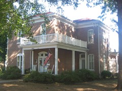 | G.J. George House | building | 2006 | 06000006 |
 | Turney-Hall House (Additional Documentation) | building | 2018 | 100002329 |
Every wildfire the federal occurrence database records inside this county: 2 of them, burning under an acre. None started naturally and 1 was recorded as arson. Each settlement page carries the fires within five miles of it.
| Reported cause | Fires |
|---|---|
| Debris and open burning | 1 |
| Arson/incendiarism | 1 |
The five largest, by the area the report gives. One of them was set deliberately.
| Date | Cause | Size | Reported by | Name on the report |
|---|---|---|---|---|
| 4 July 2008 | Debris and open burning | under an acre | Illinois Division of Forestry Resources | 56 |
| 7 April 2002 | Arson/incendiarism | under an acre | Illinois State Fire Marshal's Office | not named |
Every settlement page carries the fires within five miles of it - see the settlement index below.
The NOAA Storm Events Database holds 315 reports for this county, causing 2 deaths, 51 injuries and about $16,138,000 in recorded property damage. Each settlement page carries the reports that name it.
| Kind of event | Reports |
|---|---|
| Thunderstorm Wind | 106 |
| Hail | 72 |
| Flood | 55 |
| Flash Flood | 36 |
| Tornado | 29 |
| Funnel Cloud | 8 |
| Heavy Rain | 7 |
| Lightning | 2 |
The most serious of them, by death, then injury, then recorded damage. The accounts are quoted exactly as the forecast office filed them.
| When | Event | Place named | Harm | What the report says |
|---|---|---|---|---|
| April 2002 | Tornado (F3) | Wayne City | 1 killed, 42 hurt, $4,000,000 | The tornado entered Wayne County about a half mile north of Illinois Route 15, then proceeded to move northeast to a point about 1.5 miles north of Wayne City. The tornado then paralleled Route 15 just north of Sims. The tornado continued moving east toward Fairfield, and passed through the southern part of Fairfield with F-3 intensity winds. The tornado then travelled slightly south of east toward Golden Gate. The tornado weakened east of Golden Gate and finally dissipated in extreme eastern Wayne County near Ellery. The sole fatality occurred 4 miles west of Wayne City, when a 47-year-old man was killed inside his mobile home. Of the 42 hospital-treated injuries, 13 were critical. A total of 35 homes were destroyed, and 16 received major damage. The average wind speed in the tornado was 130 to 170 MPH, with peak winds at or approaching 200 MPH. The F-3 damage was located near Sims, southern sections of Fairfield, near Merriam, and areas west and north of Wayne City. Vehicles were picked up and deposited in houses. Well-constructed houses lost roofs and some walls. Weaker structures, including a tavern near Sims, were demolished. |
| December 2013 | Flood | Mt Erie | 1 killed, $20,000 | Flooding of the Little Wabash River affected low-lying fields and woodlands. A 42-year-old woman died after driving her car into the backwaters of the Little Wabash River northeast of Fairfield. Using an airplane, state police located her body beneath ice not far from the abandoned car. She was taken to a local hospital, where she was pronounced dead of hypothermia. |
| April 2011 | Tornado (EF2) | Fairfield | 2 hurt, $400,000 | One house was destroyed, with part of the roof removed and separation of some walls. A machine shed and several grain bins were destroyed. About a dozen power poles were snapped. Dozens of trees were snapped or uprooted. A tank was blown about 150 yards. An outbuilding was blown across Route 15. The average path width was 100 yards. Peak winds were estimated near 120 mph. |
| June 1990 | Tornado (F4) | not stated | 2 hurt, $250,000 | no account filed |
| June 1990 | Tornado (F4) | not stated | 1 hurt, $2,500,000 | no account filed |
| April 1994 | Thunderstorm Wind | Fairfield | 1 hurt, $500,000 | Three mobile homes were destroyed in Fairfield injuring one person. Trees and power lines were also blown down in Fairfield. |
| December 1957 | Tornado (F3) | not stated | 1 hurt, $250,000 | no account filed |
| March 2009 | Tornado (EF1) | Wayne City | 1 hurt, $40,000 | Intermittent damage was observed along the path of this tornado, which contained peak winds near 100 mph. Most of the damage was tree damage. Some trees were snapped and uprooted. Two structures were damaged, including a mobile home that was not tied down. The mobile home was rolled while a man was inside. He suffered broken ribs. The other damaged structure was a 40-by-60 foot storage shed. About one third of the shed was blown over a storage barn into a house, causing significant damage to the house. Debris was blown into a field across the street. A power pole was blown down. The tornado was witnessed about four miles north of Sims in the middle of a field. It was described as a black rotating cloud. |
| April 2006 | Thunderstorm Wind | Wayne City | 1 hurt, $40,000 | In Wayne City, several trees were down, and a church sustained extensive damage to siding and shingles. A portion of a trailer roof was torn off and deposited in power lines. Peak winds were estimated near 70 MPH. Near the Interstate 64 junction with State Route 242 (exit 100), trees were down and a mobile home was overturned and destroyed. A baby in the home received a bump on the head but no serious injuries. About a mile north of Sims, a barn was blown down. An unoccupied mobile home south of Boyleston was blown off its foundation and wrapped around a tree. |
| January 1989 | Tornado (F2) | not stated | $2,500,000 | no account filed |
| May 1996 | Hail | Zenith | $700,000 | no account filed |
| April 2006 | Thunderstorm Wind | Fairfield | $500,000 | Wind damage was widespread in and around Fairfield. The most severe damage was in the Fairfield Municipal Airport area, where a crop-dusting company's hangar collapsed onto three airplanes. Metal from the building blew across a highway and wrapped around a stop sign. A metal storage building across from the hangar was destroyed. Just north of the hangar, the roof was partially peeled off an auto body shop, and a corner of a residential garage was damaged by flying debris. A mobile home was shifted off its foundation about a half mile north of the airport. Metal debris was tangled in power lines near the airport. The roof was peeled off an agribusiness about two to three miles north of Fairfield. The roof of radio station WFIW was partially ripped off. The steeple was blown off a church and through the front of the building while it was in session, but nobody was hurt. Dozens of trees were snapped or uprooted across Fairfield, and several television antennae were snapped. Many of the downed trees were weak or shallow-rooted trees. There was underpinning and shingle damage to other homes in Fairfield. A train ran into downed tree limbs across railroad tracks, causing minor damage to the train and forcing the closure of most railroad crossings in Fairfield for two hours. A National Weather Service damage survey indicated straight-line winds from 70 to 80 MPH were responsible for the damage, which was oriented from southwest to northeast. Relatively light damage occurred in rural areas between Fairfield and the Hamilton County line, where a barn was destroyed and a couple of homes were damaged. A person near the Hamilton County line photographed an apparent "gustnado," and numerous other citizens on the northern edge of Fairfield reported apparent gustnadoes. |
| April 1994 | Thunderstorm Wind | Cisne | $500,000 | Windows were blown out of homes in Zenith. Several farm buildings were destroyed one mile north of Cisne. |
| July 2023 | Thunderstorm Wind | Wayne City | $250,000 | Nearly all of the damage was in the south and west parts of Wayne City. There were dozens of trees and large tree branches down, several of which landed on homes and cars. Some light structure damage occurred to a mobile home. A large tree fell onto a barn. Roofing from an open, lean-to style machine shed was torn off. Power poles and lines were down. |
| May 1983 | Tornado (F1) | not stated | $250,000 | no account filed |
| April 1996 | Tornado (F3) | Barnhill | $200,000 | no account filed |
| November 2013 | Tornado (EF2) | Sims | $150,000 | This tornado touched down on the southwest side of Sims. It quickly intensified and destroyed a double wide mobile home on the northeast side of Sims. The tornado continued northeast and crossed Highway 15, producing tree and power pole damage. The tornado moved east across the Wayne County landfill, damaging the building on the grounds. The tornado continued into the north side of Fairfield, producing mainly minor damage to homes. Peak winds in this tornado were estimated near 135 mph. The maximum intensity was on the northeast side of Sims. |
| August 2007 | Thunderstorm Wind | Fairfield | $150,000 | Roofs were damaged, and numerous trees were blown down by very strong thunderstorm winds. The wind damage was primarily from the east side of Fairfield eastward along Route 15. The entire roof was blown off a residence, and another residence was partially unroofed. The unroofed home sustained heavy water damage. Part of the roof of a church was torn off. A few very large pine trees were uprooted. At least a few of the downed trees landed on houses and vehicles. Three small telephone poles were blown down. A cornfield was flattened. |
| March 2024 | Tornado (EF1) | Merriam | $120,000 | Numerous pine trees snapped near the base along the track northeast of Fairfield. One home near the beginning of the track had roof damage (a tarp covered half of the roof) with a nearby tree having many large branches broken. Further east, an anchored mobile home was lifted up and leaned over, not overturned but uninhabitable due to sustained major damage. Another home further ENE had substantial soffit and porch damage along with an old TV tower toppled and many snapped pine trees on the property. Peak winds were estimated at 90 mph. |
| January 2008 | Thunderstorm Wind | Fairfield | $120,000 | Roofs were blown off homes and other buildings in and around Fairfield. A roof was blown off of a house along U.S. Highway 45 just south of town. U.S. Highway 45 was closed between Interstate 64 and Fairfield after trees blew across the highway. A 60-foot tall concrete silo was blown over, and several large grain bins were destroyed. Temperatures dropped 26 degrees in less than 30 minutes at the Fairfield airport. |
| May 2024 | Thunderstorm Wind | Zenith | $110,000 | A swath of straight line winds of 75 to 85 mph began about 6 miles northwest of Johnsonville, IL and extended east northeast into the town of Rinard. Most of the damage in this swath included uprooted trees, as well as trees or large tree branches snapped. There were some homes that were damaged due to trees falling on them. Several power lines and poles were also broken because of fallen trees. A localized downburst occurred within this area of straight line winds on the south end of Brush Creek Campground, just west northwest of Sam Dale Lake. Winds of around 100 mph caused a small swath of several dozen snapped pine trees. A few buildings on the campground were also damaged. The wind damage swath is estimated at 11.5 miles in length and 1.7 miles in width. Additional wind damage was also reported in other parts of the county with this line of storms, but it was much more sporadic. |
| April 2011 | Thunderstorm Wind | Middleton | $100,000 | A mobile home that was not tied down was blown away. A few farm sheds were damaged near the Jefferson County line. Telephone poles were snapped near Keenes. |
| March 2008 | Flood | Johnsonville | $100,000 | Some roads were closed, including the main road from Orchardville to Keenes. The excessive rainfall caused gravel and dirt roads to become very soft. Heavy traffic was urged to stay on paved roads. |
| October 2001 | Thunderstorm Wind | Countywide | $100,000 | Numerous trees, power lines, and power poles were blown down. Some fell on houses and cars. The hardest hit area was from Cisne to Mount Erie. Significant roof damage was reported throughout Geff. U.S. Route 45 at Geff was closed about two hours after dozens of trees were blown down and power lines fell across the road. Near Mount Erie, a truck loaded with hazardous materials was struck by a falling tree, but there were no injuries. |
| June 1999 | Thunderstorm Wind | Fairfield | $100,000 | Over 75 trees were uprooted or destroyed in Fairfield. Several homes and businesses were damaged. Fallen debris caused several complete street blockages. Most of the building damage was due to trees falling on structures. One large house was heavily damaged by a huge walnut tree that was uprooted. The roof was reportedly blown off a dry-cleaning business. |
| May 1995 | Thunderstorm Wind | Countywide | $100,000 | Numerous trees were blown down across the county. |
| April 1996 | Flash Flood | Fairfield | $100,000 | no account filed |
| April 2011 | Thunderstorm Wind | Fairfield | $90,000 | Numerous trees and limbs were blown down. In Fairfield, a large tree landed on a house, and a structure containing three businesses was heavily damaged. In the Barnhill area, a 30-by-40 foot building was destroyed. |
| March 2009 | Tornado (EF2) | Enterprise | $90,000 | Several structures were damaged. Half of the roof was blown off one house. A well-built storage barn was blown into another house. Debris was blown several hundred yards. Debris from a house impacted a second house 250 yards away. The second house had only minor structural damage. A large metal barn partially caved in when a small grain elevator blew onto it. Peak winds were estimated near 122 mph. The tornado crossed into Clay County. |
| May 2017 | Flood | Wayne City | $80,000 | Major flooding occurred on the Skillet Fork River. At the Wayne City river gage, the river crested at 22.81 feet early on the 1st. Flood stage is 15 feet. This crest was within a couple inches of the April, 2011 flood crest. At least one home was sandbagged east of Route 45 in the Mill Shoals area. There was widespread flooding of lowlands, including county roads and bridges. |
| May 2016 | Hail | Fairfield | $80,000 | A slow-moving severe thunderstorm crossed the city of Fairfield, producing a swath of quarter to golf-ball size hail across the city. |
| March 2009 | Tornado (EF0) | Orchardville | $80,000 | The tornado continued from Jefferson County just a short distance into Wayne County. A grain bin was thrown about 100 yards. A storage bin was toppled. A farm auger was knocked over. Metal decking or shingles were stripped off barns. There was shingle and siding damage to homes. Peak winds were estimated near 85 mph. |
| January 2008 | Thunderstorm Wind | Keenes | $75,000 | Roofs were off of buildings, and a farm silo was destroyed. Trees were uprooted, and some tops of trees were blown off. Damage was reported to an outbuilding. |
| March 2006 | Tornado (F1) | Keenes | $70,000 | The tornado began at a place called Middleton in rural southwest Wayne County. A calf was injured after being picked up and thrown against a barn. A few mobile homes were overturned. Swirl marks were still visible in a field four days after the tornado. An old schoolhouse was destroyed, mostly due to a large tree falling on it. Numerous very large trees were uprooted and snapped. Boards were impaled into the ground. One home received extensive roof damage. Two barns were destroyed, and several barns were damaged. Shingles were blown off roofs. There were several eyewitness accounts of the tornado. Peak winds were estimated near 110 MPH. Average path width was 250 yards. |
| February 2011 | Thunderstorm Wind | Orchardville | $60,000 | The damage swath extended from Orchardville along and north of Highway 161 to a mile northeast of Mount Erie. Much of the damage was near Cisne, where a house porch was damaged, a large outbuilding was destroyed, and a sign was damaged. A couple of barns and garages were blown over or destroyed. There was minor damage to a couple of sturdier buildings, including a church steeple in Orchardville. Several trees and power lines were down. A power pole was blown over. |
| April 2011 | Thunderstorm Wind | Johnsonville | $60,000 | Six homes received minor damage in Johnsonville. A wind gust to 64 mph was measured near Cisne. Numerous trees and limbs were damaged. |
| July 2025 | Flash Flood | Cisne | $50,000 | Significant flash flooding occurred in Cisne and in northwestern Wayne County. Multiple roads were impacted and sandbagging was deployed. Cisne received a radar estimated 3-4 inches of rain, while northwestern portions of Wayne County approached half a foot of rain for the day. |
| April 2024 | Thunderstorm Wind | Fairfield | $50,000 | Thunderstorm winds from a storm line moving eastward caused a large tree to fall onto a trailer home on Le Roy St in Fairfield. |
| August 2024 | Thunderstorm Wind | Mayberry | $50,000 | Two large barns were destroyed, one in the Mayberry area and one south of I-64 east of Gammon Curve. Several locations had large trees broken off. |
| June 2022 | Thunderstorm Wind | Johnsonville | $50,000 | Emergency management estimated winds gusted to 65 mph. Sporadic tree damage was reported across northern Wayne County. Power lines and trees were down near Johnsonville. Six miles north of Cisne along the Clay County line, five to six power poles were down on U.S. Highway 45. Cisne was out of power for 15 hours due to the downed poles. |
| March 2006 | Flash Flood | Fairfield | $50,000 | Four roads in Fairfield were flooded. Flood damage to vehicles was reported at a car dealership. |
| May 1996 | Thunderstorm Wind | Geff | $50,000 | no account filed |
| April 2024 | Thunderstorm Wind | Hubbard | $35,000 | Due to downburst winds, a couple of power poles snapped and a metal roof was blown off of a large building along US 45 south of County Road 620 N. |
| March 2024 | Thunderstorm Wind | Fairfield | $30,000 | Widespread tree and powerline damage occurred near Fairfield. |
| March 2022 | Tornado (EF0) | Fairfield | $30,000 | A brief touchdown occurred along Walnut Grove Road. There was a public eyewitness of the tornado. Shingle damage occurred to a few houses. Some larger branches on a few trees were snapped. There was minor damage to a couple of outbuildings. Peak winds were estimated near 75 mph. |
| June 2018 | Thunderstorm Wind | Zenith | $30,000 | Widespread damaging winds occurred across western parts of the county, mainly west of Fairfield. A wind gust to 75 mph was measured by a personal weather station at Wayne City. |
| May 2016 | Hail | Wayne City | $30,000 | A slow-moving severe thunderstorm moved into western Wayne County, dumping quarter to ping-pong ball size hail between Wayne City and Orchardville. |
| June 2014 | Thunderstorm Wind | Fairfield | $30,000 | The microburst downed several trees and numerous tree limbs. A small shed was destroyed. Two wooden power poles were broken. The microburst began just west of County Road 600E and continued along and north of County Road 8 for approximately 1.25 miles. The width of the microburst about 750 yards. |
| October 2007 | Thunderstorm Wind | Mt Erie | $30,000 | A 40 by 72 foot machine shed was destroyed. 10 to 15 trees in a row were snapped or uprooted. There was minor damage to a metal garage. |
| April 1999 | Lightning | Fairfield | $30,000 | Fire broke out at a Ford car dealership after lightning struck. The metal building was totally involved in flames. |
| May 2011 | Flood | Johnsonville | $30,000 | no account filed |
| June 2019 | Thunderstorm Wind | Golden Gate | $25,000 | Approximately 30 trees were downed just southeast of the community of Golden Gate on County Road 650N. Additional damage in that same vicinity included part of a shed roof and an outdoor plastic playhouse. The path length of the microburst was one-third of a mile, and the width was 400 yards. Peak winds were estimated near 85 mph based on drone footage of the damage. |
| June 1997 | Thunderstorm Wind | Fairfield | $25,000 | Lots of trees were down in the southeast part of Fairfield. Two houses sustained major damage when trees fell on them. The damage was to the upper portions of the houses. |
| June 1997 | Thunderstorm Wind | Mt Erie | $25,000 | A number of trees were blown down. Part of the roof of a silage feed bunk was blown off. An elevator was blown over. Just south of Mt. Erie, a large tree fell across a house trailer, a pickup, and a car, damaging all three. |
| May 2004 | Thunderstorm Wind | Countywide | $25,000 | no account filed |
| April 1989 | Tornado (F1) | not stated | $25,000 | no account filed |
| October 1989 | Tornado (F2) | not stated | $25,000 | no account filed |
| May 1973 | Tornado (F1) | not stated | $25,000 | no account filed |
| April 1972 | Tornado (F1) | not stated | $25,000 | no account filed |
| July 1958 | Tornado (F2) | not stated | $25,000 | no account filed |
The Survey's mineral resources record lists 2 workings inside this county. None of them still produces: all are closed or unrecorded. Each settlement page carries the workings within five miles of it.
| Commodity | Workings |
|---|---|
| Stone, Crushed/Broken | 1 |
| Sand and Gravel, Construction | 1 |
The least common of them first, because a county's hundredth gravel pit says nothing its first ten did not.
| Where | Site | Commodity | Status | Recorded |
|---|---|---|---|---|
| Brown Pit | Sand and Gravel, Construction | Past Producer | ||
| Wayne County Highway Department | Stone, Crushed/Broken | Past Producer |
Named settlements recorded in the Geographic Names Information System, each with the topographic sheets covering it. Villages, hamlets and abandoned places alike. Each is shown with the nearest named watercourse or landform and the survey quadrangle it falls on.
Barnhill township · 62809 · On Watson Creek · Burnt Prairie quadrangle
8 sheets, 1948 to 1982
Elm River township · 62823 · On Endsley Creek · Enterprise quadrangle
10 sheets, 1948 to 1986
Leech township · 62843 · On White Oak Slough · Golden Gate quadrangle
8 sheets, 1943 to 1982
Barnhill township · 62837 · Near Pig Ridge · Burnt Prairie quadrangle
8 sheets, 1948 to 1982
Leech township · 62837 · On Jack Creek · Burnt Prairie quadrangle
8 sheets, 1948 to 1982
Massilon township · 62446 · On Ash Slough · Albion NW quadrangle
8 sheets, 1943 to 1982
No longer a settlement
Massilon township · 62837 · On Evans Creek · Fairfield quadrangle
8 sheets, 1948 to 1982
The vanished settlements of Wayne County: the places named above that are no longer on the map.