BlockBefore
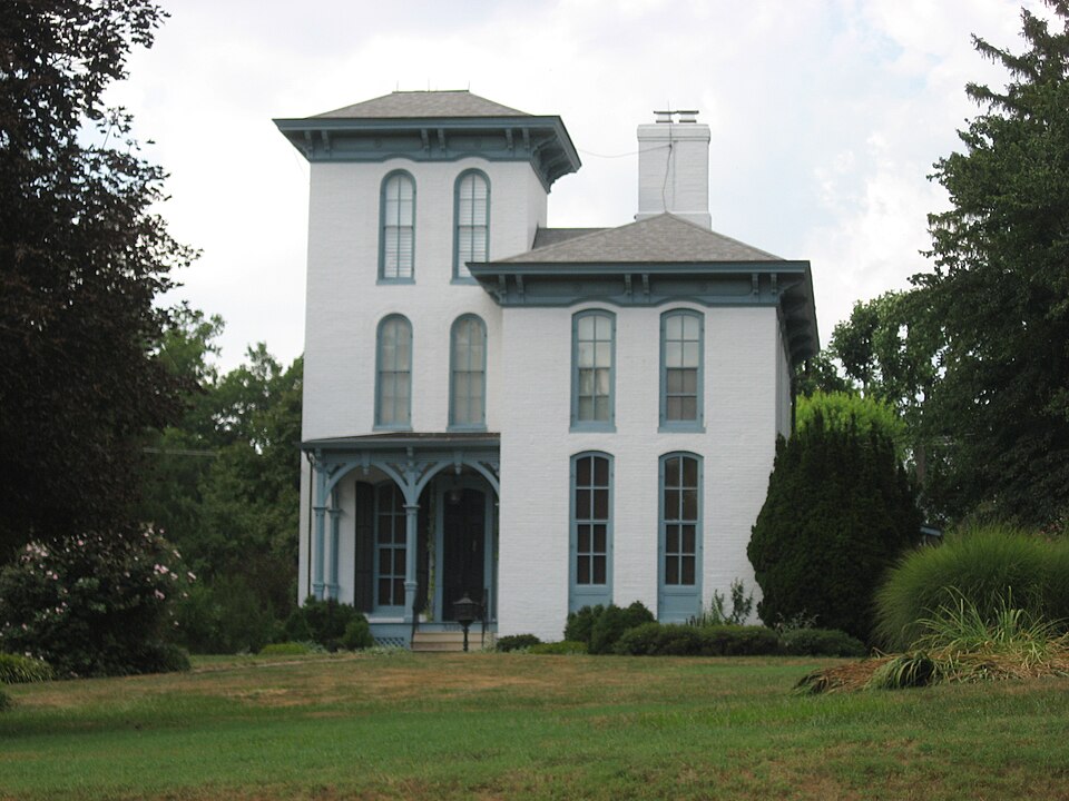
Photograph of John Carney House
Photograph by Nyttend, Public domain. Via Wikimedia Commons.

John Carney House

Listed on the National Register of Historic Places in 1983.

From the record

“The John Carney House is a historic house located at 306 E. The house was built in 1871 for John Carney, a local businessman, and his wife Elizabeth, who came from the locally prominent Koerner family.”

Wikipedia article John Carney House, CC BY-SA 4.0.

One of 40 National Register listings published here for Madison County · listed in 1983 · category: Building.

Sources: the Wikipedia article · the case file at the National Archives · the National Register database, National Park Service

The listing

  • What is counted as historic. The nomination lists 1 building as contributing to the listing.
  • Listed as. Carney, John, House - the National Register files a house under its owner's surname.
  • Address. 306 E. Market St., Troy, 62294
  • When was it listed? July 1983
  • Category. building
  • Township. Jarvis township
  • Architectural style. Renaissance Revival architecture
  • National Register reference number. 83000327 - the number the National Park Service assigned this property when it was listed, and the key its nomination file is catalogued under at the National Archives.

Storms near this property

37 since 1997

Regional context, not property-specific evidence. The National Weather Service names Troy, the town this property stands in, in 37 storm reports between 1997 and 2025: 19 hail, 14 thunderstorm wind, 4 tornado. No death or injury is recorded in these reports. Each account below is quoted exactly as the forecast office filed it, from the NOAA Storm Events Database, and each date opens the federal record of that event.

WhenEvent Place namedHarm What the report says
April 2024Thunderstorm WindTroy$100,000Thunderstorm winds caused downed trees and downed power poles and power lines. Some trees fell into houses in Marine, and a tree was snapped in half at Rustic Acres Jellystone Park. Communities within the damage path were Troy, Marine, Hamel, Worden, Williamson, Livingston, and New Douglas.
April 2024Tornado (EF0)Troy$5,000A tornado touched down along Lower Marine Road, around 3 miles northeast of Troy. It snapped off numerous tree limbs and uprooted several large trees as it tracked northeast along Lower Marine Road. One residence sustained minor roof damage. The tornado lifted and dissipated just west of Silver Creek. Overall, the was rated EF0 (max wind speed of 80 mph) with a path length of 0.33 miles and a max path width of 75 yards. No deaths or injuries were reported.
July 2023Thunderstorm WindTroy-Numerous large tree limbs and power lines were blown down between Troy and Highland. Also, in Highland four power poles were snapped off.
June 2014Thunderstorm WindTroy-Thunderstorm winds blew down about 20 power poles along U.S. 40 between Illinois Route 162 and Triad Middle School. Also, several power poles were blown down in St. Jacob.
February 2006HailTroy-A storm spotter reported 1 inch hail.
July 2006Tornado (F0)Troy-A tornado first formed south southeast of Troy about 200 yards south of the intersection of East Kirsch Road and Blackjack Road. A machine shed was totally destroyed at this location. The tornado moved rapidly east southeast to Highway 4 near Lilac Road. At this location a farm home sustained severe damage from a large fallen tree while two machine sheds sustained minor damage. Many trees were severed at the top along the tornado path.
July 2006Tornado (F0)Troy-A tornado first formed near the intersection of Blackjack and Lebanon Roads and moved east southeast at about 50 mph. One farmstead sustained minor machine shed damage while several power poles were downed east of Highway 4. Numerous large trees were severed near the top along the path.
July 2006Thunderstorm WindTroy-Several trees were blown down.
July 2006Thunderstorm WindTroy-Numerous large tree limbs were blown down.
May 2005Thunderstorm WindTroy-A storm spotter reported several large tree limbs down.
May 2004HailTroy-Storm spotters reported 3/4 inch hail.
May 2004HailTroy-Storm spotters reported golfball size hail near Interstate 270 and 55.
August 2004Thunderstorm WindTroy-Amateur radio spotters reported 6 to 8 inch diameter tree limbs down which also took down some power lines.
March 2025HailTroy-no account filed
April 2017HailTroy-no account filed
January 2012HailTroy-no account filed
September 2012HailTroy-no account filed
April 2011HailTroy-no account filed
January 2008HailTroy-no account filed
May 2008HailTroy-no account filed
September 2008HailTroy-no account filed
August 2005Thunderstorm WindTroy-no account filed
May 2003Thunderstorm WindTroy-no account filed
July 2003Thunderstorm WindTroy-no account filed
June 2002Thunderstorm WindTroy-no account filed
April 2001HailTroy-no account filed
February 1999Tornado (F0)Troy-no account filed
August 1999Thunderstorm WindTroy-no account filed
May 1998Thunderstorm WindTroy-no account filed
June 1998HailTroy-no account filed
July 1998Thunderstorm WindTroy-no account filed
March 1997HailTroy-no account filed

Every storm recorded in Madison County

Map coverage status

No historic map-sheet match is published for this property yet. That does not mean no map exists. This record needs a coordinate-quality review before it can be joined to a sheet boundary. Browse the county's mapped places while that work is pending.

Listed places nearby

6 within 8 miles

Other National Register properties close enough to walk or drive between, ordered by distance from this one. Both positions come from the same geocoding pass that matched these properties to their map sheets.

Photograph PropertyDistance Listed
William W. Jarvis House0.2 miles1988
Glen Carbon Grade School5.6 miles2014
Glen Carbon Village Hall and Firehouse5.6 miles2018
Collinsville Township High School6.3 miles2023
LeClaire Historic District6.4 miles1979
Marine Chapter House6.5 miles1980

Sources for this property

National Archives recordThe nomination case file for reference 83000327 in Record Group 79.
Wikipedia articleCommunity-written account of this property, licensed CC BY-SA.
Madison CountyAll 40 listed properties in this county.

Provenance

  • Listing record. National Park Service National Register of Historic Places, listed-properties dataset, current to 2026-05-22.
  • Map join. Address geocoded through the United States Census geocoder, then tested against the published boundary of every sheet in the USGS Historical Topographic Map Collection.
  • How this page is made. Listing fields come from federal records; map-sheet coverage is a labelled coordinate-to-boundary calculation, not a source-field claim.
  • Storms. NOAA National Centers for Environmental Information, Storm Events Database https://www.ncei.noaa.gov/stormevents/ A work of the United States government, no copyright under 17 U.S.C. 105. Narratives are quoted verbatim from the National Weather Service report and are not edited or summarised.