 Block
Colfax, Indiana
9 topographic sheets cover this place, the earliest surveyed in 1953 and the latest in 1984. It stands in Perry Township. It lies in ZIP code area 46035. The Survey maps it on the Colfax quadrangle. 702 people lived here at the 2020 count. It stands 840 feet above sea level.
On record in Colfax
Buildings and businesses the archive holds for this place. Each opens its own page, with the source record it came from.
On the National Register 2 records
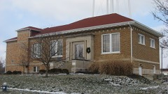 Colfax Carnegie Librarylisted 1994
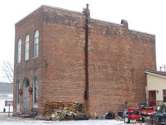 Rosenberger Buildinglisted 1984
Population over time
2 figuresColfax grew from 691 to 702 between 2010 and 2020. These are the recorded population figures Wikidata holds for this place, reached through the Geographic Names Information System number this page is keyed on rather than by name, so they belong to this place and not to another of the same name. Most are census counts, but not all are: an early figure may be a founding or settlement estimate, and an estimate published within five years of a census is left out. The change column is computed, and is left blank where more than 20 years separate a figure from the one before it, because a gap that long is not a change between two counts.
| Year | People | Change |
|---|---|---|
| 2010 | 691 | |
| 2020 | 702 | +11 (+2%) |
Topographic sheets covering this place
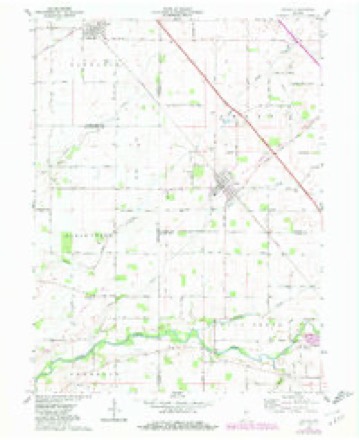
5 surveys from 9 printed sheetsMatched by testing this settlement's coordinate against the published boundary of every sheet in the United States Geological Survey's historical collection. Each opens the scanned sheet at the Survey.
- 1953 USGS Danville quadrangle1:250000, 3 printings
- 1955 USGS Danville quadrangle1:250000
- 1956 USGS Danville quadrangle1:250000
- 1962 USGS Colfax quadrangle1:24000, 2 printings
- 1984 USGS Lafayette quadrangle1:100000, 2 printings




In the county-history sources
1,406 words on this townshipCombination Atlas Map of Clinton County, Indiana, published 1878 names this settlement in its chapter on Perry Township. These are the passages that mention it, exactly as the scans read.
About 1870, the L., C. & S. W. Railroad was completed, passing direetly through Colfax. business of every kind. From that day until the present it has grown very rapidly. The appearance of her business houses, her splendid sehool building, churches, and many comfortable dwellings all indieate an industrious, intelligent, enterprising class of citizens.
Passage source: Combination Atlas Map of Clinton County, Indiana, published 1878.
About the year 1840, in the heart of a dense forest, was built for school purpose a log house, which was conveniently fitted up with all the appliances necessary to success in school teaching. Elijah Mitchell and George Kenall were among the early teachers, who made their names famous as instructors of the young. The course of study there was not materially different from that of other schools of' that early day, and comprised a knowledge of reading, spelling, writing, cyphering and flogging.
Passage source: Combination Atlas Map of Clinton County, Indiana, published 1878.
The Indianapolis, Cincinnati & Lafayette Railroad, at first called the Indianapolis Railroad, was located in the year 1849, and finished about the year 1852, when Mr. Strowd laid out a town, to which he gave the cognomen Midway, which, after a while, grew into our present Colfax. In time, the tastes of the people became so cultivated as to render the appearance of the old log school house odious, and they erected, on the same location, a frame school house, to which the young, of course, were proud to go. This house, however, at last, grew too small, and an old church was appropriated to the use of school. Here gathered the motley crowd of children into an unhandy and uncomfortable room, to receive instruction from either the primary or principal teacher.
Passage source: Combination Atlas Map of Clinton County, Indiana, published 1878.
Machine-read from a century-old scan, so expect the errors a machine makes: misspelled names, dropped words, stray characters.
Read the whole chapter on Perry Township - it names this place 3 more 3 times.
Storms near this place
15 since 1998Regional context, not property-specific evidence. The National Weather Service names Colfax in 15 storm reports between 1998 and 2025: 10 thunderstorm wind, 3 hail, 1 flash flood, 1 tornado. No death or injury is recorded in these reports. Each account below is quoted exactly as the forecast office filed it, from the NOAA Storm Events Database, and each date opens the federal record of that event.
| When | Event | Place named | Harm | What the report says |
|---|---|---|---|---|
| March 2023 | Tornado (EF2) | Colfax | $700,000 | Continuation of the tornado that first impacted Montgomery and Boone Counties (as an EF1 and EF0, respectively). The tornado continued to track to the northeast, parallel to and roughly 0.8 miles southeast of West Manson Colfax Road, while intensifying. Near the intersection of County Roads 700 South and 750 West a homestead ascertained EF1-intensity damage, with 2 outbuildings on cinder blocks completely destroyed, the collapse of chimney and significant roof damage.||The tornado then reached peak intensity as an EF2 with peak winds of 120 mph, for about 0.5 miles prior to crossing US Highway 52 at the intersection with County Road 650 South. Through this most-intense segment, a large homestead lost large sections of roof structure, with a garage's brick walls blown out, while a large and poorly-anchored barn was destroyed; with a collapse of a nearby communications tower. EF1-intensity damage continued for another 1.6 miles towards Interstate Route 65, as a few barns were completely destroyed across this rural portion of southwestern Clinton County.||The tornado caused minimal EF0-intensity damage for the following 2 miles, including where it crossed Interstate Route 65, while occasionally dropping debris the vortex had picked up earlier in its path. The circulation restrengthened to EF1 intensity for its final 1.7 miles, causing significant damage just before ending about 3 miles southwest of Frankfort: hardwood trees were downed at County Road 400 South; before extensive damage near County Road 300 South which included the destruction of several barns/farm outbuildings among corresponding tree damage, including a concrete tower and a silo (at separate buildings) both leaning southwest, while another farm outbuilding's roof panels were wrapped around trees. |
| August 2014 | Thunderstorm Wind | Colfax | $30,000 | WLFI reported numerous trees and power lines down in Colfax due to damaging thunderstorm wind gusts. Some of the trees were large white oaks. Many large sugar maple limbs were down too. Hail accompanied the wind resulting in some siding and roofing damage. No information on the size of the hail. |
| March 2025 | Thunderstorm Wind | Colfax | $20,000 | Top edge of brick facade on the front of a building extending above the roof line was damaged by thunderstorm wind gusts. |
| July 2023 | Thunderstorm Wind | Colfax | $20,000 | Thunderstorm winds downed power lines at County Roads 700 West and 380 South. |
| March 2025 | Thunderstorm Wind | Colfax | $10,000 | Thunderstorm wind gusts downed 9 power poles along County Road 750 West. |
| June 2016 | Thunderstorm Wind | Colfax | $5,000 | A barn was destroyed in this location due to damaging thunderstorm wind gusts. |
| June 2023 | Hail | Colfax | - | Thunderstorm hail continued into southeastern Clinton County, as large as softballs in Kirklin. |
| June 2023 | Hail | Colfax | - | Thunderstorm hail over southwestern Clinton County, with hail as large as 1.50 inches east of Coalfax. |
| November 2013 | Thunderstorm Wind | Colfax | - | An estimated 65 mph thunderstorm wind gust was observed in this location. |
| April 2011 | Thunderstorm Wind | Colfax | - | A thunderstorm wind gust, estimated at 60 mph, was reported from this location. |
| June 2008 | Thunderstorm Wind | Colfax | - | Trees were knocked down due to damaging thunderstorm winds. |
| June 2007 | Thunderstorm Wind | Colfax | - | Trees were reported down by a trained spotter due to severe damaging thunderstorm winds. |
| June 2007 | Hail | Colfax | - | no account filed |
| August 2002 | Flash Flood | Colfax | - | no account filed |
| November 1998 | Thunderstorm Wind | Colfax | - | no account filed |
Nearest settlements
The eight closest, with where each one stands in the county. Distances are straight-line, computed from the Geographic Names Information System coordinates.
Elsewhere
Matched on this settlement's Geographic Names Information System number rather than its name, so it cannot be a different place of the same name in another state.
| Wikipedia article on Colfax | An encyclopaedic summary. Its text is share-alike, so it is linked here rather than copied. |
| Wikidata item Q3293466 | The structured record the population and elevation above come from. Public domain (CC0). |
Provenance
This settlement is recorded in the Geographic Names Information System as feature 432758. The sheet list is computed by point-in-boundary test against the United States Geological Survey's historical topographic inventory. Both are works of the United States government and carry no copyright under 17 U.S.C. 105.
Storms. NOAA National Centers for Environmental Information, Storm Events Database https://www.ncei.noaa.gov/stormevents/ A work of the United States government, no copyright under 17 U.S.C. 105. Narratives are quoted verbatim from the National Weather Service report and are not edited or summarised.