 Block
Frankfort, Indiana
10 topographic sheets cover this place, the earliest surveyed in 1953 and the latest in 1984. It stands in Center Township. It lies in ZIP code area 46041. The Survey maps it on the Frankfort quadrangle. 16,715 people lived here at the 2020 count. It stands 850 feet above sea level.
Research this city
On record in Frankfort
Buildings and businesses the archive holds for this place. Each opens its own page, with the source record it came from.
On the National Register 8 records
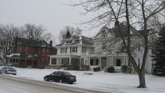 Christian Ridge Historic Districtlisted 2003
 Clinton County Courthouselisted 1978
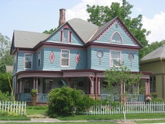 Charles H. and Emma Condon Houselisted 1997
 Frankfort Commercial Historic Districtlisted 1998
 Old Frankfort Stone High Schoollisted 1979
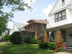 South Frankfort Historic Districtlisted 2009
- Parkview Home of Clinton Countylisted 2018
- TPA Parklisted 2019
Population over time
2 figuresFrankfort grew from 16,422 to 16,715 between 2010 and 2020. These are the recorded population figures Wikidata holds for this place, reached through the Geographic Names Information System number this page is keyed on rather than by name, so they belong to this place and not to another of the same name. Most are census counts, but not all are: an early figure may be a founding or settlement estimate, and an estimate published within five years of a census is left out. The change column is computed, and is left blank where more than 20 years separate a figure from the one before it, because a gap that long is not a change between two counts.
| Year | People | Change |
|---|---|---|
| 2010 | 16,422 | |
| 2020 | 16,715 | +293 (+2%) |
Topographic sheets covering this place
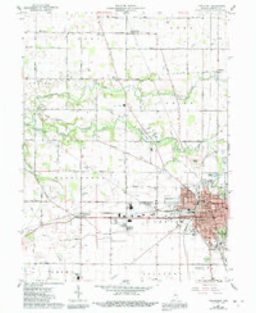
5 surveys from 10 printed sheetsMatched by testing this settlement's coordinate against the published boundary of every sheet in the United States Geological Survey's historical collection. Each opens the scanned sheet at the Survey.
- 1953 USGS Danville quadrangle1:250000, 3 printings
- 1955 USGS Danville quadrangle1:250000
- 1956 USGS Danville quadrangle1:250000
- 1961 USGS Frankfort quadrangle1:24000, 3 printings
- 1984 USGS Lafayette quadrangle1:100000, 2 printings




In the county-history sources
5,310 words on this townshipCombination Atlas Map of Clinton County, Indiana, published 1878 names this settlement in its chapter on Center Township. These are the passages that mention it, exactly as the scans read.
Mr. Armstrong is still a resident of the township, owning a well improved farm, situated near Frankfort. He and the Douglass brothers are the only persons who settled in the township in 1878 who are yet living and still residents of the county.
Passage source: Combination Atlas Map of Clinton County, Indiana, published 1878.
During the year 1829, the following sturdy, energetic men were added to the little colony: John Pence, who settled on the farm where he is now living - he is among those who entered land in 1827, being the tract upon which Frankfort now stands; John Furgeson, on the farm belonging to Mr. Blind; J. R. Kelley, on the farm where he is still living; Samuel Di Maxwell; Peter Fudge, on the farm owned by the heirs of Armantrout; William Pence, on the land owned by his son, Perry; Moses Fudge, where A. J. Dolson resides ; John McCrary, on the land belonging to Fentzmaker; Eli Armantrout, on eighty acres of the land now included in the County Poor Farm; Arthur Compton, on the Scroggy farm; Solomon Young, on the land at present owned by Mr. Given; Samuel E. Holliday, on the land now a part of the city of Frankfort; Matthias Young, on the Grey estate; Jesse Carter, on. the farm owned by his son William ; James Allen, on the Coleman farm; Joseph Steel, Sr., the land belonging to Mr. Holliday; Robert Smith, on the land of Peter Rush; Andrew Kenney, on the Catterlin farm; and Henry Fudge, who made his home with William Pence.
Passage source: Combination Atlas Map of Clinton County, Indiana, published 1878.
The first marriage in the township was that of James Timmons to Elizabeth Nichols, in 1829. As this was before the organization of the county, Mr. Timmons was compelled to go to La Fayette for his marriage license. The marriage ceremony was performed by Zabina Babcock, a Justice of the Peace. ` "The first death was that of J. M. Bowls, which occurred in the year 1830. He was buried in what is called the Bunnell grave yard. 3 f the land of Center Township is for fertility ity is not to be excelled. This irie, settled
Passage source: Combination Atlas Map of Clinton County, Indiana, published 1878.
Machine-read from a century-old scan, so expect the errors a machine makes: misspelled names, dropped words, stray characters.
Read the whole chapter on Center Township - it names this place 8 more 8 times.
Mines and quarries near this place
2 within 5 milesRegional context, not property-specific evidence. The federal mineral resources record lists 2 workings within 5 miles of Frankfort: 2 producers. All of them still produce. What was taken out: Stone, Sand and Gravel, Construction. Distance is straight-line from the map coordinates, so a quarry counted here may appear on a neighbouring settlement's page as well.
| Where | Site | Commodity | Status | Recorded |
|---|---|---|---|---|
| Clinton County Highway Department | Stone | Producer | ||
| Frankfort Sand and Gravel Pit | Sand and Gravel, Construction | Producer |
Storms near this place
60 of 80 shownRegional context, not property-specific evidence. The National Weather Service names Frankfort in 80 storm reports between 1994 and 2026: 39 thunderstorm wind, 25 hail, 6 flash flood, 6 flood. The reports record 7 injuries. Each account below is quoted exactly as the forecast office filed it, from the NOAA Storm Events Database, and each date opens the federal record of that event.
| When | Event | Place named | Harm | What the report says |
|---|---|---|---|---|
| July 1996 | Thunderstorm Wind | Frankfort | 6 hurt, $2,000,000 | no account filed |
| November 2017 | Thunderstorm Wind | Frankfort | 1 hurt, $205,000 | Part of the Walmart's roof collapsed and the front of the store was damaged due to damaging straight-line thunderstorm winds. Two semi truck was knocked over as well. One man inside an overturned truck was taken to the hospital for non-life threatening injuries. A church's steeple was bent by the severe wind. Multiple trees and large branches were snapped and the roof of Frankfort High School sustained some minor damage. Many other homes and structures sustained damage as well. |
| July 2003 | Flash Flood | Frankfort | $1,000,000 | no account filed |
| July 2005 | Tornado (F1) | Frankfort | $250,000 | An F1 tornado touched down briefly on the northeast side of Frankfort, destroying a garage and causing damage to other structures. |
| April 2004 | Tornado (F1) | Frankfort | $250,000 | A low-topped supercell produced an F1 tornado near Frankfort. The tornado destroyed 2 garages and a high school scoreboard and also damaged a barn. |
| June 2023 | Thunderstorm Wind | Frankfort | $50,000 | Large tree downed on an unoccupied car by thunderstorm wind gusts. Numerous powerlines also downed. |
| May 2011 | Thunderstorm Wind | Frankfort | $50,000 | Twenty high voltage towers in a row were twisted or knocked to the ground near 1900 West Barner Street due to damaging thunderstorm wind gusts. This location is just north of State Route 28 and just outside the business park. |
| March 2022 | Thunderstorm Wind | Frankfort | $40,000 | Thunderstorm winds blew down a tree that that fell on and damaged two cars. |
| September 2005 | Thunderstorm Wind | Frankfort | $20,000 | A grain silo was blown over. |
| January 2008 | Thunderstorm Wind | Frankfort | $15,000 | A garage was blown into a porch due to damaging thunderstorm winds. Broken power poles were also found in Frankfort. |
| July 1997 | Thunderstorm Wind | Frankfort | $15,000 | Thunderstorm winds damaged a barn roof northwest of Frankfort. |
| August 2014 | Thunderstorm Wind | Frankfort | $12,000 | Trees were downed from Delphi to Frankfort due to damaging thunderstorm wind gusts. Duke Energy reported numerous service calls because of this. |
| June 2010 | Thunderstorm Wind | Frankfort | $12,000 | A semi-truck was blown over on State Route 28 due to thunderstorm wind gusts. The time this event occurred is estimated. |
| August 2009 | Thunderstorm Wind | Frankfort | $10,000 | Multiple trees were downed in Frankfort due to thunderstorm wind gusts. |
| May 2006 | Thunderstorm Wind | Frankfort | $10,000 | A semi was blown off the highway. |
| May 2022 | Thunderstorm Wind | Frankfort | $5,000 | Thunderstorm winds snapped a large tree in half. |
| July 1994 | Thunderstorm Wind | Frankfort | $5,000 | Trees were downed, and the windows were blown out of a house. |
| July 2005 | Lightning | Frankfort | $3,000 | Lightning caused a fire on the front porch of a home. |
| December 2021 | Thunderstorm Wind | Frankfort | $2,500 | Power poles and three inch tree limbs broken by thunderstorm wind gusts. |
| March 2026 | Thunderstorm Wind | Frankfort | $2,000 | A small tree was snapped by thunderstorm wind gusts near its base. |
| May 2024 | Thunderstorm Wind | Frankfort | $2,000 | Several large tree limbs downed by thunderstorm wind gusts. |
| October 2021 | Thunderstorm Wind | Frankfort | $2,000 | A tree of unknown size along with numerous medium to large tree limbs downed by thunderstorm wind gusts within the city limits. |
| July 2015 | Thunderstorm Wind | Frankfort | $1,000 | A tree was reported down north of Frankfort due to damaging thunderstorm wind gusts. |
| April 2013 | Flood | Frankfort | $1,000 | Some streets in the city were flooded due to thunderstorm heavy rainfall. |
| July 2008 | Flash Flood | Frankfort | $1,000 | Severe street flooding was reported as a result of heavy rainfall. |
| October 2007 | Thunderstorm Wind | Frankfort | $1,000 | A large tree was reported across the road in town and power lines were also reported down due to damaging thunderstorm winds. |
| May 2006 | Thunderstorm Wind | Frankfort | $1,000 | Power lines and trees were downed. |
| September 2018 | Flood | Frankfort | $500 | The 911 Center reported standing water near the intersection of State Road 75 and County Road 200 North due to heavy rainfall. |
| October 1996 | Thunderstorm Wind | Frankfort | $500 | no account filed |
| April 2019 | Flood | Frankfort | $250 | There were some reports of flooding along several roads in and around Frankfort due to heavy rainfall. Some of the flooding had already receded at the time of reporting. |
| June 2023 | Hail | Frankfort | - | Thunderstorm hail as large as nickels reported in Frankfort. |
| May 2014 | Hail | Frankfort | - | Thunderstorm wind gusts of up to 50 mph were also reported. |
| November 2011 | Hail | Frankfort | - | Quarter sized hail was reported at the Clinton County EMA office. |
| November 2011 | Hail | Frankfort | - | Golf ball sized hail was reported by an ambulance driver at the intersection of Jackson and Wabash Streets. |
| February 2009 | Flood | Frankfort | - | Two Frankfort, Indiana residences of unspecified location were evacuated due to high water. Sandbags were put in place near the high school. State Route 28 was closed due to flooding. Report was received by the Frankfort police. |
| June 2009 | Hail | Frankfort | - | Nickel sized hail was observed on the north side of Frankfort. |
| January 2008 | Thunderstorm Wind | Frankfort | - | The wind gust was measured by a mesonet. |
| January 2008 | Thunderstorm Wind | Frankfort | - | Trees were reported down around the city due to damaging thunderstorm winds. |
| January 2008 | Thunderstorm Wind | Frankfort | - | Trees were reported down due to damaging thunderstorm winds. |
| October 2007 | Hail | Frankfort | - | Hail was reported on SR 38. |
| March 2005 | Thunderstorm Wind | Frankfort | - | A few trees were blown down west of Frankfort. |
| June 2005 | Thunderstorm Wind | Frankfort | - | Numerous trees and power lines were blown down in Frankfort. |
| June 2005 | Thunderstorm Wind | Frankfort | - | Light to moderate structural damage was reported to some homes, and the top of a semi trailer was blown off. A factory roof was torn off and tractor trailers were blown over. A personal weather station measured a wind gust to 91 mph. |
| July 2005 | Thunderstorm Wind | Frankfort | - | Trees were blown down. |
| September 2005 | Thunderstorm Wind | Frankfort | - | Trees were downed. |
| July 1999 | Thunderstorm Wind | Frankfort | - | Numerous trees and power lines were down across town. |
| March 2024 | Hail | Frankfort | - | no account filed |
| March 2017 | Hail | Frankfort | - | no account filed |
| July 2012 | Hail | Frankfort | - | no account filed |
| May 2011 | Hail | Frankfort | - | no account filed |
| June 2008 | Hail | Frankfort | - | no account filed |
| June 2008 | Thunderstorm Wind | Frankfort | - | no account filed |
| April 2006 | Hail | Frankfort | - | no account filed |
| May 2006 | Thunderstorm Wind | Frankfort | - | no account filed |
| May 2006 | Hail | Frankfort | - | no account filed |
| May 2006 | Hail | Frankfort | - | no account filed |
| January 2005 | Flash Flood | Frankfort | - | no account filed |
| May 2005 | Hail | Frankfort | - | no account filed |
| June 2005 | Thunderstorm Wind | Frankfort | - | no account filed |
| June 2005 | Hail | Frankfort | - | no account filed |
Nearest settlements
The eight closest, with where each one stands in the county. Distances are straight-line, computed from the Geographic Names Information System coordinates.
| Map | Place | Distance | Sheets |
|---|---|---|---|
| East Park | 1.0 miles | 9 | |
| Kentwood | 1.1 miles | 9 | |
| Woodside Park | 1.1 miles | 10 | |
| Wesley Manor | 1.2 miles | 10 | |
| Wilshire | 1.2 miles | 9 | |
| Risse | 1.3 miles | 9 | |
| Antioch | 3.6 miles | 10 | |
| Jefferson | 4.2 miles | 10 |
Elsewhere
Matched on this settlement's Geographic Names Information System number rather than its name, so it cannot be a different place of the same name in another state.
| Wikipedia article on Frankfort | An encyclopaedic summary. Its text is share-alike, so it is linked here rather than copied. |
| Wikidata item Q2018193 | The structured record the population and elevation above come from. Public domain (CC0). |
Provenance
This settlement is recorded in the Geographic Names Information System as feature 434761. The sheet list is computed by point-in-boundary test against the United States Geological Survey's historical topographic inventory. Both are works of the United States government and carry no copyright under 17 U.S.C. 105.
Mines and quarries. USGS Mineral Resources Data System (MRDS) https://mrdata.usgs.gov/mrds/ A work of the United States government, no copyright under 17 U.S.C. 105.
Storms. NOAA National Centers for Environmental Information, Storm Events Database https://www.ncei.noaa.gov/stormevents/ A work of the United States government, no copyright under 17 U.S.C. 105. Narratives are quoted verbatim from the National Weather Service report and are not edited or summarised.