 Block
La Fontaine, Indiana
12 topographic sheets cover this place, the earliest surveyed in 1953 and the latest in 1986. It stands in Liberty Township. It lies in ZIP code area 46940. It stands on Badger Creek. The Survey maps it on the La Fontaine quadrangle. 798 people lived here at the 2020 count. It stands 801 feet above sea level.
On record in La Fontaine
Buildings and businesses the archive holds for this place. Each opens its own page, with the source record it came from.
On the National Register within a mile 1 record
The National Register names another town for these. They stand within one mile of this settlement's coordinate.
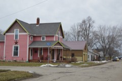 LaFontaine Historic Districtlisted 2014 · 0.1 miles away
Population over time
2 figuresLa Fontaine fell from 875 to 798 between 2010 and 2020. These are the recorded population figures Wikidata holds for this place, reached through the Geographic Names Information System number this page is keyed on rather than by name, so they belong to this place and not to another of the same name. Most are census counts, but not all are: an early figure may be a founding or settlement estimate, and an estimate published within five years of a census is left out. The change column is computed, and is left blank where more than 20 years separate a figure from the one before it, because a gap that long is not a change between two counts.
| Year | People | Change |
|---|---|---|
| 2010 | 875 | |
| 2020 | 798 | -77 (-9%) |
Topographic sheets covering this place
5 surveys from 12 printed sheetsMatched by testing this settlement's coordinate against the published boundary of every sheet in the United States Geological Survey's historical collection. Each opens the scanned sheet at the Survey.
- 1953 USGS La Fontaine quadrangle1:24000, 2 printings
- 1953 USGS Muncie quadrangle1:250000, 5 printings
- 1956 USGS Muncie quadrangle1:250000
- 1969 USGS La Fontaine quadrangle1:24000, 2 printings
- 1986 USGS Wabash quadrangle1:100000, 2 printings


In the county-history sources
6,695 words on this townshipHistory of Wabash County Indiana, published 1914 names this settlement in its chapter on Liberty Township. These are the passages that mention it, exactly as the scans read.
As has been l)riefiy narrated in tlie sketch of the early settlement of the county, the Grant family represented the fir.st permanent settlers in this section, making their homes on the creek which l^ears their name, on the eastt-rn edge of the Big Indian Reserve, near the present Village of La Fontaine.
Passage source: History of Wabash County Indiana, published 1914.
A large number of arrivals is credited to that year. Jesse D. Scott, Baptist minister and subsequently elected associate judge, came in 1835. He was one of quite a colony from Fayette County. He was then in his thirty-second year and had worked for about a year on the - canal. ^Ir. Scott took up land in section 23, near what was afterward the Town of America, and during the following twenty years was prominent as a i)reacher in the Baptist and Christian churches, as well as in material and public affairs. About 1841 he took a claim on the Indian Reserve west of La Fontaine and cleared and improved a farm there. i\Ir. Scott and his good wife raised a family of fourteen children, two of whom died as soldiers in the Union army. He himself passed away in 1864.
Passage source: History of Wabash County Indiana, published 1914.
Tile first religious meeting lield in Liberty Townsliip was at the eal)in of William Grant l)y EUU'r Daniel Jackson, the widely known preacher of the Disciples of Christ, who was living west of the Town of Wabash. These services were held in 1835. On the 4th of August, 1836, eiglit meml)ers of that denomination organized the noted Boundary Church. The organization was effected at the house of Williani Grant by I'^lder Jackson and Elder -Jefferson ]\Iatlock, in what is now La Fontaine, and consisted of the following: Henry \V. ^McPherson and wife, Lucas ]\lorgan and wife, William K. Hale and wife, AVilliam Grant iind Rebecca Grant, wife of Daniel Grant. The meetings were at first held in .Mr. Grant's house and afterward in the schoolhouse that stood on the site of the church finally built for the society, a mile and a half north of La Fontaine, at the east side of the old Indian boundary line and nearly at the geogi'aphical center of the township.
Passage source: History of Wabash County Indiana, published 1914.
Machine-read from a century-old scan, so expect the errors a machine makes: misspelled names, dropped words, stray characters.
Read the whole chapter on Liberty Township - it names this place 12 more 12 times.
Mines and quarries near this place
2 within 5 milesRegional context, not property-specific evidence. The federal mineral resources record lists 2 workings within 5 miles of La Fontaine: 2 past producers. None of them still produces. What was taken out: Sand and Gravel, Construction. Distance is straight-line from the map coordinates, so a quarry counted here may appear on a neighbouring settlement's page as well.
| Where | Site | Commodity | Status | Recorded |
|---|---|---|---|---|
| Jalapa Pit | Sand and Gravel, Construction | Past Producer | ||
| Mcginnis Sand and Gravel Pit | Sand and Gravel, Construction | Past Producer |
Storms near this place
17 since 2000Regional context, not property-specific evidence. The National Weather Service names La Fontaine in 17 storm reports between 2000 and 2023: 8 hail, 6 thunderstorm wind, 1 lightning, 1 flash flood. No death or injury is recorded in these reports. Each account below is quoted exactly as the forecast office filed it, from the NOAA Storm Events Database, and each date opens the federal record of that event.
| When | Event | Place named | Harm | What the report says |
|---|---|---|---|---|
| July 2001 | Lightning | La Fontaine | $50,000 | A two story wood frame house was destroyed by fire after being struck by lightning. No injuries. |
| August 2023 | Hail | La Fontaine | $500 | A member of the public estimated 1.25 inch hail was falling in La Fontaine. |
| June 2020 | Thunderstorm Wind | La Fontaine | - | Several trees down. |
| November 2013 | Tornado (EF2) | La Fontaine | - | A tornado which produced EF2 damage in Grant county briefly entered southern Wabash county, causing damage some minor damage to the roof and metal panels on a pole barn before quickly dissipating. The tornado intensity in Wabash county was on the lower end of EF0 and lasted roughly a minute at best. |
| June 2010 | Thunderstorm Wind | La Fontaine | - | Emergency management officials reported a few trees blown down. |
| May 2006 | Thunderstorm Wind | La Fontaine | - | A 65 mph gust was recorded, with pea size hail also occurring. |
| May 2005 | Thunderstorm Wind | La Fontaine | - | Numerous large tree branches down. |
| June 2005 | Thunderstorm Wind | La Fontaine | - | Large tree reported blown down. |
| May 2004 | Thunderstorm Wind | La Fontaine | - | Emergency management reported trees down near La Fontaine. |
| July 2003 | Flash Flood | La Fontaine | - | Law enforcement reported Highway 218 closed due to flash flooding near La Fontaine. |
| May 2019 | Hail | La Fontaine | - | no account filed |
| June 2010 | Hail | La Fontaine | - | no account filed |
| March 2006 | Hail | La Fontaine | - | no account filed |
| May 2002 | Hail | La Fontaine | - | no account filed |
| April 2001 | Hail | La Fontaine | - | no account filed |
| October 2001 | Hail | La Fontaine | - | no account filed |
| May 2000 | Hail | La Fontaine | - | no account filed |
Nearest settlements
The eight closest, with where each one stands in the county. Distances are straight-line, computed from the Geographic Names Information System coordinates.
| Map | Place | Distance | Sheets |
|---|---|---|---|
| America | 1.1 miles | 12 | |
| Treaty | 4.8 miles | 13 | |
| Mount Vernon | 5.5 miles | 13 | |
| Somerset | 5.7 miles | 13 | |
| Lincolnville | 6.0 miles | 14 | |
| College Corner | 8.9 miles | 14 | |
| South Haven | 9.5 miles | 13 | |
| Wabash | 10.0 miles | 13 |
Elsewhere
Matched on this settlement's Geographic Names Information System number rather than its name, so it cannot be a different place of the same name in another state.
| Wikipedia article on La Fontaine | An encyclopaedic summary. Its text is share-alike, so it is linked here rather than copied. |
| Wikidata item Q1976205 | The structured record the population and elevation above come from. Public domain (CC0). |
Provenance
This settlement is recorded in the Geographic Names Information System as feature 449679. The sheet list is computed by point-in-boundary test against the United States Geological Survey's historical topographic inventory. Both are works of the United States government and carry no copyright under 17 U.S.C. 105.
Mines and quarries. USGS Mineral Resources Data System (MRDS) https://mrdata.usgs.gov/mrds/ A work of the United States government, no copyright under 17 U.S.C. 105.
Storms. NOAA National Centers for Environmental Information, Storm Events Database https://www.ncei.noaa.gov/stormevents/ A work of the United States government, no copyright under 17 U.S.C. 105. Narratives are quoted verbatim from the National Weather Service report and are not edited or summarised.