 Block
Shirley, Indiana
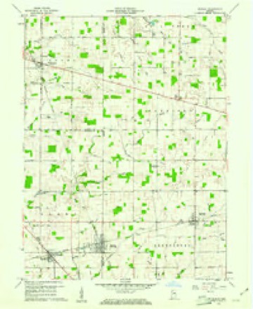
8 topographic sheets cover this place, the earliest surveyed in 1953 and the latest in 1986. It stands in Brown Township. It lies in ZIP code area 47384. It stands on Shirley Drain. The Survey maps it on the Shirley quadrangle.
On record in Shirley
Buildings and businesses the archive holds for this place. Each opens its own page, with the source record it came from.
On the National Register 1 record
 Jane Ross Reeves Octagon Houselisted 2001
Topographic sheets covering this place
4 surveys from 8 printed sheetsMatched by testing this settlement's coordinate against the published boundary of every sheet in the United States Geological Survey's historical collection. Each opens the scanned sheet at the Survey.
- 1953 USGS Cincinnati quadrangle1:250000, 3 printings
- 1957 USGS Cincinnati quadrangle1:250000
- 1960 USGS Shirley quadrangle1:24000, 2 printings
- 1986 USGS New Castle quadrangle1:100000, 2 printings



What happened here
An account from the chapter on Brown township. The inset identifies its exact source book and publication year.
Storm
On May 12, 1886, Wilkinson was partially destroyed by a cyclone, in which Glenn Smith, little son of John Smith, also Samuel White, who resided just east of the town, were killed, and Mr. White's daughter was seriouslv injured. Wilkinson was also visited by the storm of June 25, 1902, in which one glass factory was blown down and several men seriously injured, two of them dying from the effects of their injuries.
In the county-history sources
34,023 words on this townshipHistory of Hancock County, Indiana, from Its Earliest Settlement by the "pale Face," in 1818, Down to 1882, published 1882 names this settlement in its chapter on Brown Township. These are the passages that mention it, exactly as the scans read.
On the 25th of March, 1873, he had the misfortune to lose his wife, who was a most estimable lady, and sincerely mourned by all who knew her. On the 15th day of August, 1874, l^c was again married, choosing for his companion Nancy Garner, with whom he is still happily living.
Passage source: History of Hancock County, Indiana, from Its Earliest Settlement by the "pale Face," in 1818, Down to 1882, published 1882.
First Settlers. - The first settlers in tliis t(nvnship were James JUirris, John Shirley, Thomas Craig, William Smith, William Arnett, Obadiah and John Eastes, J. A. Dunn, Thomas Rodgers, Isaac Snider, John Dance, Daniel Skinner, Archy Smith, Benjamin Percell, Charles Fish, Landis Eastes, ITance Steel, and the Beechman family. Burris, Smith, Rodgers, and Dance were from Ohio ; Shirley and Craig were from Kentucky ; Snider from Virginia ; and Skinner from Delaware. At a little later date came George Grist, Joseph Wright, J. W. Shelbv. John and wSamuel Steel, John and William Collin-;, Jacob Smitli, W, A. Dunn, Lawrence and O. O. II u-voy, E, Sco::Len, S. Arnett, Owen Gritlith, J. II. M ir V.iy, J. W. Jam ob^ll,. and the Barnards and Parkers.
Passage source: History of Hancock County, Indiana, from Its Earliest Settlement by the "pale Face," in 1818, Down to 1882, published 1882.
The first minister in charge was Samuel Lamb, followed by Freeman and John Cain ; they by Freeman and R. H. Smith ; the last of whom served till 1875, when the Fortville circuit was divided and the Pleasant Grove church attached to the McCordsville circuit. Since which time the following divines have led the flock: R. B. Powell, T. J. Elkin, and G. N. Philipp, the last of whom is the present minister.
Passage source: History of Hancock County, Indiana, from Its Earliest Settlement by the "pale Face," in 1818, Down to 1882, published 1882.
Machine-read from a century-old scan, so expect the errors a machine makes: misspelled names, dropped words, stray characters.
Read the whole chapter on Brown Township - it names this place 18 more 18 times.
Storms near this place
4 since 2000Regional context, not property-specific evidence. The National Weather Service names Shirley in 4 storm reports between 2000 and 2023: 4 thunderstorm wind. No death or injury is recorded in these reports. Each account below is quoted exactly as the forecast office filed it, from the NOAA Storm Events Database, and each date opens the federal record of that event.
| When | Event | Place named | Harm | What the report says |
|---|---|---|---|---|
| June 2021 | Thunderstorm Wind | Shirley | $15,000 | Large tree limb of unknown size downed onto car by thunderstorm wind gusts. |
| July 2023 | Thunderstorm Wind | Shirley | $10,000 | Roof damage to a church steeple caused by thunderstorm wind gusts with the bell dislodged from the steeple. Tree damage noted nearby. |
| June 2021 | Thunderstorm Wind | Shirley | $5,000 | Utility pole and lines downed by thunderstorm wind gusts at the intersection of State Road 234 and Shirley Road. |
| August 2000 | Thunderstorm Wind | Shirley | - | no account filed |
Nearest settlements
The eight closest, with where each one stands in the county. Distances are straight-line, computed from the Geographic Names Information System coordinates.
| Map | Place | Distance | Sheets |
|---|---|---|---|
| Wilkinson | 1.7 miles | 8 | |
| Warrington | 3.2 miles | 9 | |
| Nashville | 5.0 miles | 9 | |
| Willow Branch | 5.8 miles | 9 | |
| Pleasant Hill | 6.1 miles | 8 | |
| Milners Corner | 6.3 miles | 9 | |
| Charlottesville | 7.3 miles | 9 | |
| Cleveland | 7.9 miles | 8 |
Provenance
This settlement is recorded in the Geographic Names Information System as feature 443421. The sheet list is computed by point-in-boundary test against the United States Geological Survey's historical topographic inventory. Both are works of the United States government and carry no copyright under 17 U.S.C. 105.
Storms. NOAA National Centers for Environmental Information, Storm Events Database https://www.ncei.noaa.gov/stormevents/ A work of the United States government, no copyright under 17 U.S.C. 105. Narratives are quoted verbatim from the National Weather Service report and are not edited or summarised.