 Block
Winona Lake, Indiana
12 topographic sheets cover this place, the earliest surveyed in 1953 and the latest in 1994. It stands in Wayne Township. It lies in ZIP code area 46590. The Survey maps it on the Warsaw quadrangle. 5,053 people lived here at the 2020 count. It stands 817 feet above sea level.
On record in Winona Lake
Buildings and businesses the archive holds for this place. Each opens its own page, with the source record it came from.
On the National Register 1 record
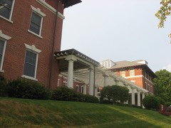 Winona Lake Historic Districtlisted 1993
Population over time
2 figuresWinona Lake grew from 4,908 to 5,053 between 2010 and 2020. These are the recorded population figures Wikidata holds for this place, reached through the Geographic Names Information System number this page is keyed on rather than by name, so they belong to this place and not to another of the same name. Most are census counts, but not all are: an early figure may be a founding or settlement estimate, and an estimate published within five years of a census is left out. The change column is computed, and is left blank where more than 20 years separate a figure from the one before it, because a gap that long is not a change between two counts.
| Year | People | Change |
|---|---|---|
| 2010 | 4,908 | |
| 2020 | 5,053 | +145 (+3%) |
Topographic sheets covering this place
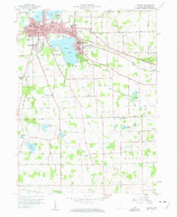
5 surveys from 12 printed sheetsMatched by testing this settlement's coordinate against the published boundary of every sheet in the United States Geological Survey's historical collection. Each opens the scanned sheet at the Survey.
- 1953 USGS Fort Wayne quadrangle1:250000, 4 printings
- 1956 USGS Fort Wayne quadrangle1:250000, 2 printings
- 1957 USGS Warsaw quadrangle1:24000, 4 printings
- 1984 USGS Fort Wayne quadrangle1:100000
- 1994 USGS Fort Wayne quadrangle1:100000




In the county-history sources
9,168 words on this townshipBiographical and Historical Reocrd of Kosciusko County, published 1887 has no passage naming this settlement, which was common for smaller places. Its township is covered in full.
The chapter on Wayne Township covers the township.
Read the chapter on Wayne Township - 9,168 words.
Mines and quarries near this place
4 within 5 milesRegional context, not property-specific evidence. The federal mineral resources record lists 4 workings within 5 miles of Winona Lake: 2 producers, 2 past producers. 2 still produce. What was taken out: Sand and Gravel, Construction, Stone. Distance is straight-line from the map coordinates, so a quarry counted here may appear on a neighbouring settlement's page as well.
| Where | Site | Commodity | Status | Recorded |
|---|---|---|---|---|
| Warsaw Street Dept. | Stone | Producer | ||
| Fuller's Sand & Gravel Pit | Sand and Gravel, Construction | Past Producer | ||
| G. and G. Sand and Gravel Pit | Sand and Gravel, Construction | Past Producer | ||
| Kosciusko Co. Hwy. Dept. | Sand and Gravel, Construction | Producer |
Storms near this place
15 since 2000Regional context, not property-specific evidence. The National Weather Service names Winona Lake in 15 storm reports between 2000 and 2025: 12 thunderstorm wind, 2 hail, 1 lightning. No death or injury is recorded in these reports. Each account below is quoted exactly as the forecast office filed it, from the NOAA Storm Events Database, and each date opens the federal record of that event.
| When | Event | Place named | Harm | What the report says |
|---|---|---|---|---|
| July 2011 | Thunderstorm Wind | Winona Lake | $500,000 | A survey of widespread damage, as well as possible tornado sightings, was performed by NWS officials. A two to three mile wide area of damage was found across the southern part of Warsaw, into much of the Village of Winona Lake. Eyewitness and video footage indicates that a funnel had formed on the leading edge of the storm just prior to the wind damage. No indications of the funnel touching down could be located. However, damage patterns and video footage indicated a downburst occurred. Winds were not fully able to reach the ground, with damage confined to numerous trees being snapped at higher levels or uprooted. Power poles and lines were also knocked down, mainly due to falling trees and tree limbs. Reports of trees falling onto several homes and cars were also received with no injuries noted. Some roof damage was observed in a few locations, including Warsaw Foundry, TTP, Inc. and Whimet, Inc. Winds were estimated between 85 and 90 mph. No specific damage figures were available, but estimates of at least $500,000 are being entered. |
| June 2025 | Thunderstorm Wind | Winona Lake | $10,000 | Tree down onto power lines which resulted in a fire. |
| July 2022 | Thunderstorm Wind | Winona Lake | $2,000 | Two healthy, one-foot diameter pine trees were snapped. |
| July 2022 | Thunderstorm Wind | Winona Lake | - | A healthy 10 inch diameter tree limb broke. Reported via Facebook. |
| May 2018 | Thunderstorm Wind | Winona Lake | - | Two large trees were snapped on the northwest side of Warsaw. Several smaller limbs also down in the area. |
| March 2017 | Thunderstorm Wind | Winona Lake | - | Law enforcement officials reported power lines down in the area. |
| July 2017 | Thunderstorm Wind | Winona Lake | - | A off duty NWS employee reported a privacy fence was blown over, with four of the posts snapped and moved about six feet. One section was lifted over a small tree. Six tree limbs, ranging up to five inches in diameter were also blown down. |
| July 2012 | Thunderstorm Wind | Winona Lake | - | A trained spotter reported a two foot diameter tree down onto power lines on South Country Club Road. |
| July 2012 | Thunderstorm Wind | Winona Lake | - | A trained spotter reported a four foot diameter tree was uprooted about a quarter mile north of County Road 300 on South Country Club Road. A four inch limb was also blown down onto power lines in the area. |
| May 2009 | Thunderstorm Wind | Winona Lake | - | An off duty NWS employee reported large tree branches being blown down on the southeast side of Warsaw. |
| June 2007 | Lightning | Winona Lake | - | Four teenagers were camping at a music festival at a local college and sought shelter under a tree, which was struck by lightning. The teeneages were indirectly injured from the strike. They ranged in age from 14 to 19. Two were admitted to a local hospital in fair conditions, with the other two being treated and released. |
| May 2000 | Thunderstorm Wind | Winona Lake | - | Tree down. |
| March 2012 | Hail | Winona Lake | - | no account filed |
| May 2005 | Thunderstorm Wind | Winona Lake | - | no account filed |
| April 2000 | Hail | Winona Lake | - | no account filed |
Nearest settlements
The eight closest, with where each one stands in the county. Distances are straight-line, computed from the Geographic Names Information System coordinates.
| Map | Place | Distance | Sheets |
|---|---|---|---|
| Warsaw | 1.8 miles | 12 | |
| Lakeside Park | 2.2 miles | 13 | |
| Highlands Park | 3.7 miles | 13 | |
| Arrowhead Park | 3.9 miles | 13 | |
| Osborn Landing | 3.9 miles | 13 | |
| Island Park | 4.3 miles | 13 | |
| Wooster | 4.4 miles | 12 | |
| Stoneburner Landing | 4.7 miles | 13 |
Elsewhere
Matched on this settlement's Geographic Names Information System number rather than its name, so it cannot be a different place of the same name in another state.
| Wikipedia article on Winona Lake | An encyclopaedic summary. Its text is share-alike, so it is linked here rather than copied. |
| Wikidata item Q2590154 | The structured record the population and elevation above come from. Public domain (CC0). |
Provenance
This settlement is recorded in the Geographic Names Information System as feature 446188. The sheet list is computed by point-in-boundary test against the United States Geological Survey's historical topographic inventory. Both are works of the United States government and carry no copyright under 17 U.S.C. 105.
Mines and quarries. USGS Mineral Resources Data System (MRDS) https://mrdata.usgs.gov/mrds/ A work of the United States government, no copyright under 17 U.S.C. 105.
Storms. NOAA National Centers for Environmental Information, Storm Events Database https://www.ncei.noaa.gov/stormevents/ A work of the United States government, no copyright under 17 U.S.C. 105. Narratives are quoted verbatim from the National Weather Service report and are not edited or summarised.