Listed on the National Register of Historic Places in 2002.
From the record
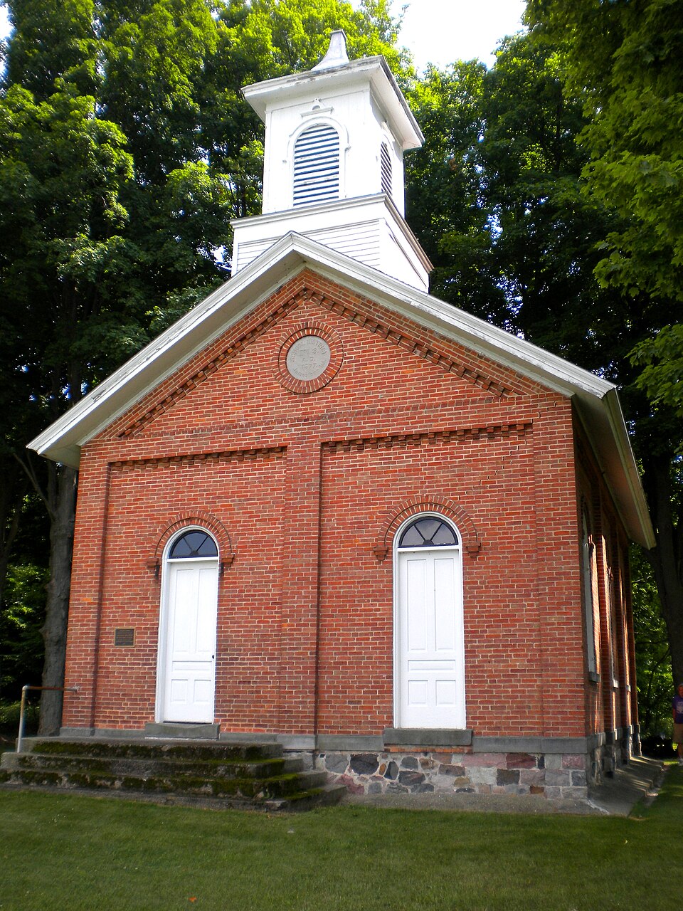
“Collins School, also known as Jamestown Township District #3 School, is a historic one-room school building located in Jamestown Township, Steuben County, Indiana. It was built in 1877, and is a one-story, rectangular, Italianate style brick building.”
Wikipedia article Collins School, CC BY-SA 4.0.
One of 17 National Register listings published here for Steuben County · listed in 2002 · category: Building.
Also known as. Indiana's Public Common and High Schools MPS
Township. Jamestown township
National Register reference number.02001173- the number the National Park Service assigned this property when it was listed, and the key its nomination file is catalogued under at the National Archives.
Jamestown Township lies in the north tier, adjoining the State of Michigan, which bounds it on the north. To the east lies Fremont Township, to the south Pleasant, and to the west Mill Grove. The township is a little less than six miles east and west, and a little more than four miles north and south. It thus contains about twenty-four square miles, or about 15,500 acres, of which say 2,000 acres are covered by water. The township contains some of the finest lakes in the county, and offers unrivaled advantages to the sportsman who desires a successful fishing trip, to the city man who needs a few weeks quiet amid attractive scenery, or to the farmer who wants to locate in as beautiful a region as is in Indiana. Lake James, the largest body of water in the county, stretches from the south line nearly to the village of Jamestown, covering half of sections 28 and 33, and parts of 21, 27 and 34. Lake Jimerson covers half of section 32. Lake George lies on sections 14 and 15, near Jamestown, and stretches into Michigan, as does Hog Lake, on section 17, and Lake Pleasant, in the northwestern corner, on 18. Others are Upper and Lower Otter lakes, on sections 26 and 2Y; Green's Lake, on 26; Failing Lake, on 35; Marsh Lake, on 25; Mud Lake, on 22, and Walters's Lake, on 13.
As mentioned in the history of Fremont Township, the first settlers arrived near Willow Prairie on one of the last days of August, 1835. Jamestown Township received some of its first permanent settlers only a few days later. Dennis Depue, John D. Depue, John Wilkins and Jared Fox were among the pioneers ot the township. They arrived Sept. 8,1835. Six weeks later, when the forests were gorgeously arrayed in all the bright and beautiful colors peculiar to the northern woods in autumn, the population of the settlement was materially increased by the arrival of Henry Depue, Sr., Michael Depue, Benjamin Depue, Henry Depue, Levi Depue and Mary Hoxter. Henry and Levi Depue settled in Orland, and John D. and Benjamin Depue located in Branch County, Mich. John Wilkins and Dennis Depue, settled in Jamestown Township, near the village of that name. Jared Fox settled in Gilead, Branch Co., Mich.
Regional context, not property-specific
evidence. The
federal wildfire occurrence database
lists 3 fires within 5 miles of Collins School
in 2019, burning about 7 acres in total. None started naturally. None was recorded as arson.
Distance is straight-line from the map coordinates, so a fire counted
here may appear on a neighbouring settlement's page as well.
Reported cause
Fires
Equipment and vehicle use
3
The most recent of
them, most recent first, with the day each was reported and the service
that recorded it.
Regional context, not property-specific
evidence. The federal mineral resources record lists
4 workings within 5 miles of Collins School: 4 past producers.
None of them still produces. What was taken out: Sand and Gravel, Construction, Stone, Crushed/Broken, Limestone, General. Distance is straight-line from the
map coordinates, so a quarry counted here may appear on a neighbouring
settlement's page as well.
Regional context, not property-specific
evidence. The National Weather Service names
Fremont, the town this property stands in, in 34 storm reports between 1998 and 2022: 19 thunderstorm wind, 13 hail, 1 lightning, 1 flood.
No death or injury is recorded in these reports. Each account below is quoted exactly as the forecast office
filed it, from the NOAA Storm Events Database, and each date
opens the federal record of that event.
LIGHTNING INDUCED FIRES DESTROYED A BARN AND KENNEL AT 3580 S CR RD 800 E. ANOTHER LIGHTNING INDUCED FIRE DESTROYED ANOTHER BARN AND FARM TRACTORS AT 3285 N CR RD 650 E WHICH TOOK FIRE FIGHTERS 40 MINUTES TO GET UNDER CONTROL.
Local emergency management performed a storm survey of damage west of Fremont. A strip mall suffered significant damage to the roof and soffits as well as broken windows. Numerous trees were reported down in the area with one onto a car. Some trees were uprooted, as large as 20 inches in diameter. Trees and a light pole were blown down at a Holiday Inn Express. The damage appeared to be consistent with straight line winds of around 70 mph. Damage is estimated at around $100,000.
Several trees were blown down, one reported to be 24 inches in diameter. A 12 inch diameter tree fell onto a parked police car, which was totaled as a result. A large cottonwood tree was blown down near Snow Lake, with debris from the tree knocking over a fence and utility shed.
Store located in "a small gully" as described by owner experienced water up to the owners knee after rainfall of around 2 inches in 3 hours. No injuries.
No historic map-sheet match is published
for this property yet. That does not mean no map exists. This record needs
a coordinate-quality review before it can be joined to a sheet boundary.
Browse the county's mapped places while that work is
pending.
Listed places nearby
6 within 8 miles
Other National Register properties close
enough to walk or drive between, ordered by distance from this one. Both
positions come from the same geocoding pass that matched these properties
to their map sheets.
Listing record. National Park Service National Register of Historic Places, listed-properties dataset, current to 2026-05-22.
Map join. Address geocoded through the United States Census geocoder, then tested against the published boundary of every sheet in the USGS Historical Topographic Map Collection.
How this page is made. Listing fields come from federal records; map-sheet coverage is a labelled coordinate-to-boundary calculation, not a source-field claim.
Wildfire. Short, Karen C. 2022. Spatial wildfire occurrence data for the United States, 1992-2020 [FPA_FOD_20221014]. 6th Edition. Fort Collins, CO: Forest Service Research Data Archive. https://doi.org/10.2737/RDS-2013-0009.6 Collected with United States Government funding and usable without additional permissions or fees.
Mines and quarries. USGS Mineral Resources Data System (MRDS) https://mrdata.usgs.gov/mrds/ A work of the United States government, no copyright under 17 U.S.C. 105.
Storms. NOAA National Centers for Environmental Information, Storm Events Database https://www.ncei.noaa.gov/stormevents/ A work of the United States government, no copyright under 17 U.S.C. 105. Narratives are quoted verbatim from the National Weather Service report and are not edited or summarised.
 Block