
BlockBefore
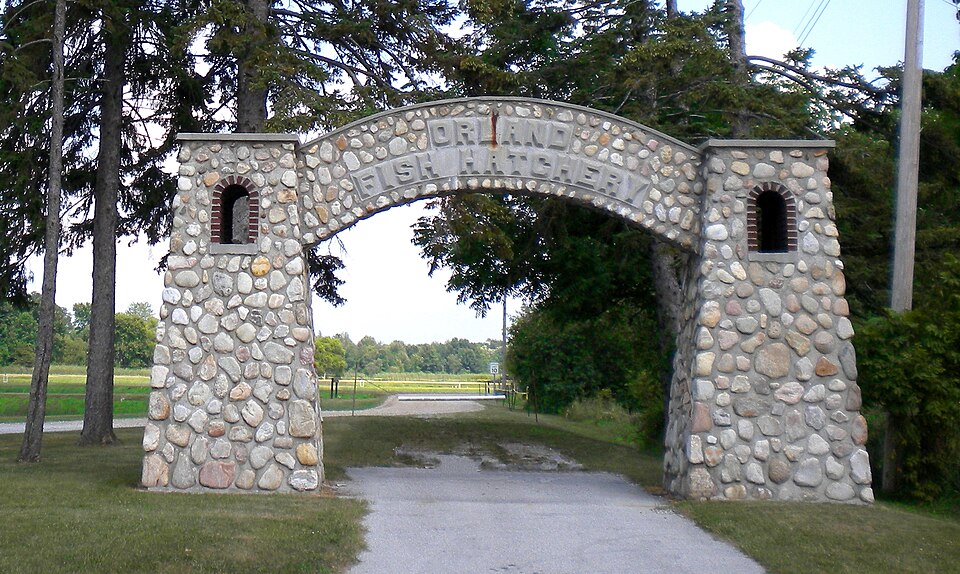
Photograph of Fawn River State Fish Hatchery
Photograph by MrHarman, CC BY-SA 3.0. Via Wikimedia Commons.

Fawn River State Fish Hatchery

Built in 1937. Listed on the National Register of Historic Places in 1997.

From the record

“Fawn River State Fish Hatchery, also known as the Orland Fish Hatchery, is a historic hatchery located at Orland and Millgrove Township, Steuben County, Indiana. It was developed between 1935 and 1937 by the Works Progress Administration, and dedicated in 1942.”

Wikipedia article Fawn River State Fish Hatchery, CC BY-SA 4.0.

One of 17 National Register listings published here for Steuben County · listed in 1997 · category: Site · built in 1937.

Sources: the Wikipedia article · the case file at the National Archives · the National Register database, National Park Service
The listing

  • Address. 6889 North IN 327, Orland, 46776
  • When was it listed? January 1997
  • Category. site
  • Also known as. New Deal Resources on Indiana State Lands MPS
  • Township. Millgrove township
  • When was it built? 1937
  • National Register reference number. 96001553 - the number the National Park Service assigned this property when it was listed, and the key its nomination file is catalogued under at the National Archives.

The ground it stands on

9,104 words

The chapter on Millgrove Township in History of Steuben County, Indiana, Together with... Biographies of Representative Citizens, published 1885 names Orland. This is what it says, exactly as the scans read.

The first settlement was made on the site of the village of Orland. This village is situated in the western part of Mill Grove Township, on sections 20 and 29, about a mile and a half south of the boundary line between the States of Michigan and Indiana, and the same distance east of the Lagrange County line. Its distance from Angola is about thirteen miles in a northwesterly direction. It is near the little stream of water called in Michigan Fawn River, more commonly known in this county as Crooked Creek. The immediate location of the village is on a level plateau of what was called burr-oak openings in early times, there being also on the southern border of the town a little scope of prairie land. The land in the whole region about Orland, for miles each way, was and is the richest and most fertile of any lands that attracted the attention of the pioneers of the country. It is not surpassed in value, all natural qualities considered, by any land elsewhere in the West.

Passage source: History of Steuben County, Indiana, Together with... Biographies of Representative Citizens, published 1885.

In the spring of 1834 John Stocker, father of L. H. Stocker, Esq., prospected for a Western home for himself and family and for a number of others who wished to " locate" out West. Mr. Stocker and the families who were interested in the prospecting tour were from Windham County, Vt. They forthwith, upon the representation of Mr. Stocker in regard to the country, started with their households, and in the summer and fall of 1834 settled on the very inviting tracts comprising what is now Orland and vicinity. It was in June or July of that year that Benjamin Pierce and wife, Abel Blanchard and family of five children, including his son who became afterward the well-known Elder Blanchard, of Wolcottville, accompanied by John Stocker and wife and four children, George D. Palmenter,wife and onechild,and S. A. Palmenter, came from Vermont and " located."

Passage source: History of Steuben County, Indiana, Together with... Biographies of Representative Citizens, published 1885.

Machine-read from a century-old scan, so expect the errors a machine makes: misspelled names, dropped words, stray characters.

Read the whole chapter on Millgrove Township - 9,104 words on its settlement, mills, schools and churches.

Fires near this property

2 since 2019

Regional context, not property-specific evidence. The federal wildfire occurrence database lists 2 fires within 5 miles of Fawn River State Fish Hatchery between 2019 and 2020, burning about 2 acres in total. None started naturally. None was recorded as arson. Distance is straight-line from the map coordinates, so a fire counted here may appear on a neighbouring settlement's page as well.

Reported cause Fires
Equipment and vehicle use2

The most recent of them, most recent first, with the day each was reported and the service that recorded it.

DateCause SizeReported by Name on the report
1 April 2019Equipment and vehicle use1.0 acresMichigan Department of Natural ResourcesBRONSON FD 0000104 - 2019
9 January 2020Equipment and vehicle use1.0 acresMichigan Department of Natural ResourcesBRONSON FD 2000006 - 2020

Every fire recorded in Steuben County

Mines and quarries near this property

3 within 5 miles

Regional context, not property-specific evidence. The federal mineral resources record lists 3 workings within 5 miles of Fawn River State Fish Hatchery: 2 past producers, 1 producer. 1 still produces. What was taken out: Sand and Gravel, Construction, Stone, Crushed/Broken. Distance is straight-line from the map coordinates, so a quarry counted here may appear on a neighbouring settlement's page as well.

Where SiteCommodity StatusRecorded
Garman PitStone, Crushed/BrokenPast Producer
Rice PitSand and Gravel, ConstructionProducer
State Line Sand and Gravel PitSand and Gravel, ConstructionPast Producer

Every working recorded in Steuben County

Storms near this property

20 since 1999

Regional context, not property-specific evidence. The National Weather Service names Orland, the town this property stands in, in 20 storm reports between 1999 and 2025: 15 thunderstorm wind, 4 hail, 1 tornado. No death or injury is recorded in these reports. Each account below is quoted exactly as the forecast office filed it, from the NOAA Storm Events Database, and each date opens the federal record of that event.

WhenEvent Place namedHarm What the report says
April 2025Tornado (EF1)Orland$100,000Damage survey from the National Weather Service along with Steuben County EMA found damage consistent with a tornado that touched down on the south side of Orland, IN. The tornado destroyed an old, small barn on the south side, before uprooting and snapping several trees and a communications pole in east Orland. The tornado damaged the roof of an apartment building, including ripping up the wood sheathing on the south end of the building. Non-conclusive, likely rear flank downdraft winds severely damaged a large barn at N 900 W and W State Rd 120 and a set of trees just off to the east. Across the street, a dozen or so trees were uprooted or snapped in a cemetery. Tree damage was also noted in the adjacent tree line. The tornado reached max width at the border of IN/MI where a large swath of significant tree damage occurred to a piece of property owned by the Indiana Toll Road. A semi-truck was reported to be blown over on the Toll Rd. The tornado crossed into Michigan with intermittent light structural and tree damage occurring near East Gilead and extending northeastward. The tornado reached maximum intensity of 105 mph (EF-1) when it struck a farm on E Pearl Road, tearing roofs off large silos, destroying a section of barn, driving 2x4 into the nearby home, and destroying another out building to the west.
March 2025Thunderstorm WindOrland$15,000Downed power lines and a broken utility pole on CR 350 N, west of IN 327.
March 2025Thunderstorm WindOrland$15,000Damage to a house as well as three sheds and a fence.
July 2023Thunderstorm WindOrland$2,000A 24 to 30 inch diameter tree was down at the intersection of SR 120 and 900 W.
August 2021Thunderstorm WindOrland$1,000The emergency manager reports a tree down.
April 2025Thunderstorm WindOrland-Spotter reports an estimated wind gusts of 98.4 mph using a hand held anemometer.
June 2022Thunderstorm WindOrland-A survey of damage a swath of tree damage extended from near Orland southeast to Lake Gage, Pine Canyon Lake, Crooked Lake and the west side of Angola. The most extensive damage occurred from the southeast side of Lake Gage to the east side of Pine Canyon Lake, Some structure damage was noted, mainly due to trees falling onto structures. Maximum winds are estimated up to 75 mph.
June 2020Thunderstorm WindOrland-EM reports multiple trees down.
May 2019Thunderstorm WindOrland-Local media reported trees uprooted or snapped from Orland to Pleasant Lake. Several roads were closed from the downed trees.
August 2018Thunderstorm WindOrland-Emergency management officials reported several tree limbs down.
June 2016Thunderstorm WindOrland-Central dispatch reported trees, tree limbs and power lines down across the northwestern part of the county.
June 2010Thunderstorm WindOrland-Emergency management officials reported a large tree down at County Road 900 West and State Route 120.
June 2010Thunderstorm WindOrland-Emergency management officials reported trees down in the area, with one onto a house.
May 2004Thunderstorm WindOrland-Emergency management reported trees down in Orland.
June 2001Thunderstorm WindOrland-Trees and power lines down.
August 2000Thunderstorm WindOrland-Several large trees blown down taking power lines down as well.
July 2008HailOrland-no account filed
May 2003HailOrland-no account filed
August 1999HailOrland-no account filed

Every storm recorded in Steuben County

Map coverage status

No historic map-sheet match is published for this property yet. That does not mean no map exists. This record needs a coordinate-quality review before it can be joined to a sheet boundary. Browse the county's mapped places while that work is pending.

Listed places nearby

3 within 8 miles

Other National Register properties close enough to walk or drive between, ordered by distance from this one. Both positions come from the same geocoding pass that matched these properties to their map sheets.

Photograph PropertyDistance Listed
Lime Lake - Lake Gage Channel and Bridge3.8 miles2019
Collins School5.6 miles2002
Combination Shelter7.4 miles1992

Sources for this property

National Archives recordThe nomination case file for reference 96001553 in Record Group 79.
Wikipedia articleCommunity-written account of this property, licensed CC BY-SA.
Steuben CountyAll 17 listed properties in this county.

Provenance

  • Listing record. National Park Service National Register of Historic Places, listed-properties dataset, current to 2026-05-22.
  • Map join. Address geocoded through the United States Census geocoder, then tested against the published boundary of every sheet in the USGS Historical Topographic Map Collection.
  • How this page is made. Listing fields come from federal records; map-sheet coverage is a labelled coordinate-to-boundary calculation, not a source-field claim.
  • Wildfire. Short, Karen C. 2022. Spatial wildfire occurrence data for the United States, 1992-2020 [FPA_FOD_20221014]. 6th Edition. Fort Collins, CO: Forest Service Research Data Archive. https://doi.org/10.2737/RDS-2013-0009.6 Collected with United States Government funding and usable without additional permissions or fees.
  • Mines and quarries. USGS Mineral Resources Data System (MRDS) https://mrdata.usgs.gov/mrds/ A work of the United States government, no copyright under 17 U.S.C. 105.
  • Storms. NOAA National Centers for Environmental Information, Storm Events Database https://www.ncei.noaa.gov/stormevents/ A work of the United States government, no copyright under 17 U.S.C. 105. Narratives are quoted verbatim from the National Weather Service report and are not edited or summarised.