 Block
From the record
One of 17 National Register listings published here for Steuben County · listed in 2019 · category: Site.
Sources: the National Register database, National Park Service
Listed on the National Register of Historic Places in 2019.
One of 17 National Register listings published here for Steuben County · listed in 2019 · category: Site.
Sources: the National Register database, National Park Service
The chapter on Millgrove Township in History of Steuben County, Indiana, Together with... Biographies of Representative Citizens, published 1885 names Angola. This is what it says, exactly as the scans read.
The first settlement was made on the site of the village of Orland. This village is situated in the western part of Mill Grove Township, on sections 20 and 29, about a mile and a half south of the boundary line between the States of Michigan and Indiana, and the same distance east of the Lagrange County line. Its distance from Angola is about thirteen miles in a northwesterly direction. It is near the little stream of water called in Michigan Fawn River, more commonly known in this county as Crooked Creek. The immediate location of the village is on a level plateau of what was called burr-oak openings in early times, there being also on the southern border of the town a little scope of prairie land. The land in the whole region about Orland, for miles each way, was and is the richest and most fertile of any lands that attracted the attention of the pioneers of the country. It is not surpassed in value, all natural qualities considered, by any land elsewhere in the West.
Passage source: History of Steuben County, Indiana, Together with... Biographies of Representative Citizens, published 1885.
Christian F. Schneider was born in the Grand Duchy of Baden, Germany, Nov. 17, 1818, a son of George Frederick and Christena (Ekkard) Schneider. His maternal grandfather was a wealthy citizen of Emmendingen, Germany. In 1846 Christian and his brother Eduard sailed for the United States, landing in New York. They proceeded to Albany where they embarked on a c«nal-boat and went to BuflFalo, thence per steamer to Toledo, Ohio, and from there to Angola, Ind. He soon found employment at his trade, a tailor, and remained in Angola a year, when his employer moved to Orland and he soon followed him. He worked as a journeyman a year, and then opened a shop of his own . In 1856 he was appointed Postmaster by James Campbell, Postmaster-General, and held the position till 1861. Retaining the office in the same location in the building occupied by him, he served as Deputy till 1865, when he was again commissioned Postmaster by William Dennison, and has since filled the position to the satisfaction of the entire community. He is a genial, courteous gentleman and esteemed by all who know him. He was married Nov. 27, 1847, to Susan Noll, daughter of George Noll, one of the pioneers of Salem Township. She died March 20, 1849, leaving one daughter - Susanna M., now Mrs. William Meek. In 1849 he was married to Melissa Tuttle. To them were born four children, three of whom are living - Frederick, David and Adelia, wife of Arthur Norton. After a year of sufifering Mrs. Schneider died
Passage source: History of Steuben County, Indiana, Together with... Biographies of Representative Citizens, published 1885.
Machine-read from a century-old scan, so expect the errors a machine makes: misspelled names, dropped words, stray characters.
Read the whole chapter on Millgrove Township - 9,104 words on its settlement, mills, schools and churches.
Regional context, not property-specific evidence. The federal mineral resources record lists 4 workings within 5 miles of Lime Lake - Lake Gage Channel and Bridge: 3 past producers, 1 producer. 1 still produces. What was taken out: Sand and Gravel, Construction, Stone, Crushed/Broken. Distance is straight-line from the map coordinates, so a quarry counted here may appear on a neighbouring settlement's page as well.
| Where | Site | Commodity | Status | Recorded |
|---|---|---|---|---|
| Garman Pit | Stone, Crushed/Broken | Past Producer | ||
| Gravel Pit | Sand and Gravel, Construction | Past Producer | ||
| Rice Pit | Sand and Gravel, Construction | Producer | ||
| State Line Sand and Gravel Pit | Sand and Gravel, Construction | Past Producer |
Regional context, not property-specific evidence. The National Weather Service names Angola, the town this property stands in, in 60 storm reports between 1996 and 2025: 39 thunderstorm wind, 17 hail, 2 lightning, 1 flood. The reports record 4 injuries. Each account below is quoted exactly as the forecast office filed it, from the NOAA Storm Events Database, and each date opens the federal record of that event.
| When | Event | Place named | Harm | What the report says |
|---|---|---|---|---|
| July 1998 | Thunderstorm Wind | Angola | 4 hurt, $250,000 | WIND DAMAGE TO 4-H BUILDING AND STRUCTURE HIT BY LIGHTNING. SEVERAL PEOPLE WERE INJURED WHEN LIGHTNING STRUCK THE 4-H BUILDING. |
| April 2011 | Lightning | Angola | $55,000 | A local newspaper reported a residence in the 300 block of East Stocker Street, in Angola, was struck by lightning, causing an attic fire. The residents were home at the time of the lightning strike and escaped without injuries. An estimated $55,000 in damage was caused to the attic area. |
| June 2023 | Thunderstorm Wind | Angola | $40,000 | A car dealership building and inventory was damaged. |
| December 2007 | Thunderstorm Wind | Angola | $25,000 | Numerous reports of downed power lines and trees across the county. |
| August 2022 | Thunderstorm Wind | Angola | $20,000 | Tree limbs and power lines are down. One tree was down on a vehicle. No injuries were reported. |
| May 2024 | Hail | Angola | $15,000 | Ping pong ball sized hail near Trine University. |
| May 2024 | Hail | Angola | $15,000 | no account filed |
| March 2025 | Lightning | Angola | $7,500 | Lightning struck a power pole near the Trine University football field. |
| July 2024 | Thunderstorm Wind | Angola | $5,000 | Power lines down on Fox Lake Road. |
| June 2005 | Thunderstorm Wind | Angola | $3,000 | Several 8 to 14 inch diameter trees, as well as power lines, were reported blown down. |
| August 2021 | Thunderstorm Wind | Angola | $2,000 | The emergency manager reports trees down in Steuben County. |
| July 2005 | Thunderstorm Wind | Angola | $2,000 | Several trees and power lines were blown down. Three trees were uprooted on the south side of Angola on old US 27. |
| March 2025 | Thunderstorm Wind | Angola | $1,000 | A 2 to 3 foot diameter healthy pine tree down. |
| July 2024 | Thunderstorm Wind | Angola | $1,000 | Tree down on Joe Wheeler St, between Broad and W Maumee. |
| June 2023 | Thunderstorm Wind | Angola | $1,000 | Ten inch diameter tree branches are down in Angola. |
| June 2001 | Thunderstorm Wind | Angola | $1,000 | Older barn flattened and windows broken out of home on Golden Lake. |
| June 2020 | Thunderstorm Wind | Angola | - | Two large trees fell. |
| July 2019 | Thunderstorm Wind | Angola | - | Trained spotters reported a large tree was blown down along with construction signs. |
| May 2019 | Thunderstorm Wind | Angola | - | Emergency management officials reported numerous trees, tree limbs and power lines down across the county. |
| June 2018 | Tornado (EF1) | Angola | - | An EF-1 tornado caused widespread, extensive tree damage, knocking down trees along adjacent railroad tracks. Minor roof damage was noted to a few structures. Maximum wind speeds are estimated around 105 mph. |
| July 2018 | Thunderstorm Wind | Angola | - | Emergency management officials reported damage to several large trees. Examination of pictures and radar data suggests classic downburst winds of around 70 mph. |
| June 2016 | Thunderstorm Wind | Angola | - | A trained spotter reported three trees down in town. |
| September 2014 | Thunderstorm Wind | Angola | - | The public recorded a 59 mph wind gust. |
| July 2014 | Thunderstorm Wind | Angola | - | Emergency management officials reported more than 20 trees uprooted. Four homes suffered significant damage. |
| September 2014 | Hail | Angola | - | Hail lasted for three minutes at the Angola High School. |
| July 2014 | Thunderstorm Wind | Angola | - | Emergency management officials reported trees and power lines down around the city. |
| November 2013 | Thunderstorm Wind | Angola | - | Emergency management officials reported multiple structures were damaged in Pleasant Lake. Power lines were blown down across the area as well. Winds estimated to 65 mph. |
| July 2012 | Thunderstorm Wind | Angola | - | A trained spotter reported several small tree limbs down. |
| July 2012 | Thunderstorm Wind | Angola | - | Local officials reported a tree blown down near the intersection of County Road 600 West and US-20. |
| July 2011 | Thunderstorm Wind | Angola | - | Emergency management officials reported trees and power lines down across the county, several blocking roads. |
| July 2011 | Thunderstorm Wind | Angola | - | Trained spotters reported numerous trees and tree limbs down in and around Angola. |
| July 2011 | Thunderstorm Wind | Angola | - | Emergency management officials reported at least 40 trees down across the county. Approximately 1000 acres of corn was blown down. |
| May 2011 | Thunderstorm Wind | Angola | - | Law enforcement officials reported numerous trees and tree limbs down across the county. |
| February 2008 | Flood | Angola | - | Numerous county roads experienced high water. Road closures were necessary, including CR 275S from Bill Deller Road and CR 100 North between State Route 327 and the Lagrange county line. No rescues or evacuations were reported because of the floodwaters. |
| May 2004 | Hail | Angola | - | Amateur radio spotter reported nickel size hail at Pleasant Lake. |
| June 2004 | Thunderstorm Wind | Angola | - | Law enforcement reported several trees down near Lake James. |
| July 2004 | Thunderstorm Wind | Angola | - | Trees reported knocked down. |
| July 2004 | Thunderstorm Wind | Angola | - | Trees reported knocked down. Power lines also reported down. |
| March 2003 | Thunderstorm Wind | Angola | - | Large tree limbs were blown onto US-20 east of Angola. |
| July 2003 | Thunderstorm Wind | Angola | - | Law enforcement reported trees and power lines down in Angola. |
| July 2003 | Thunderstorm Wind | Angola | - | Law enforcement reported trees and power lines down northwest of Angola. |
| July 2003 | Thunderstorm Wind | Angola | - | Law enforcement reported trees down east of Angola. |
| July 2003 | Thunderstorm Wind | Angola | - | Trained spotter measured a wind gust to 65 mph south of Angola. |
| September 2000 | Thunderstorm Wind | Angola | - | Trees and power lines down. |
| July 1998 | Thunderstorm Wind | Angola | - | TREES AND LARGE LIMBS DOWN. |
| June 2019 | Hail | Angola | - | no account filed |
| May 2011 | Hail | Angola | - | no account filed |
| May 2007 | Hail | Angola | - | no account filed |
| June 2006 | Hail | Angola | - | no account filed |
| September 2005 | Hail | Angola | - | no account filed |
| August 2003 | Thunderstorm Wind | Angola | - | no account filed |
| August 2003 | Hail | Angola | - | no account filed |
| August 2003 | Hail | Angola | - | no account filed |
| March 2003 | Hail | Angola | - | no account filed |
| April 2003 | Hail | Angola | - | no account filed |
| April 2001 | Hail | Angola | - | no account filed |
| May 2000 | Hail | Angola | - | no account filed |
| October 1999 | Hail | Angola | - | no account filed |
| June 1998 | Hail | Angola | - | no account filed |
| August 1996 | Thunderstorm Wind | Angola | - | no account filed |
No historic map-sheet match is published for this property yet. That does not mean no map exists. This record needs a coordinate-quality review before it can be joined to a sheet boundary. Browse the county's mapped places while that work is pending.
Other National Register properties close enough to walk or drive between, ordered by distance from this one. Both positions come from the same geocoding pass that matched these properties to their map sheets.
| Photograph | Property | Distance | Listed |
|---|---|---|---|
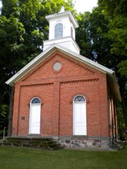 | Collins School | 3.7 miles | 2002 |
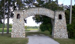 | Fawn River State Fish Hatchery | 3.8 miles | 1997 |
 | Combination Shelter | 4.1 miles | 1992 |
 | Pokagon State Park | 5.0 miles | 1996 |
 | Angola Commercial Historic District | 7.7 miles | 2010 |
| Cyrus and Jennie Cline House | 7.7 miles | 2017 |
| National Archives record | The nomination case file for reference 100004361 in Record Group 79. |
| Steuben County | All 17 listed properties in this county. |