 Block
From the record
One of 40 National Register listings published here for Wayne County · listed in 2018 · category: District.
Sources: the National Register database, National Park Service
Listed on the National Register of Historic Places in 2018.
One of 40 National Register listings published here for Wayne County · listed in 2018 · category: District.
Sources: the National Register database, National Park Service
The chapter on New Garden Township in History of Wayne County, Indiana : Together with Sketches of Its Cities, Villages and Towns, published 1884 names Fountain City. This is what it says, exactly as the scans read.
About the same time, from 1811 to 1816, the southeast part of the township was settled by Abraham Hampton, Jacob Hampton, Frank Swin, Hampton Brown, James Massey, and others whose names we cannot give. South of Newport, now Fountain City, about the same time the following persons located : Obadiah Harris, Cader Woodard, Francis Tliomas, Benjamin Thomas, Sr., and Josiah Woodard.
Passage source: History of Wayne County, Indiana : Together with Sketches of Its Cities, Villages and Towns, published 1884.
This township has a great deal of very excellent land, and its farmers are mainly industrious and enterprising. The only stream of water in tbe township is Nolan's Fork, and this stream runs from a northeast to a southwest direction, and passes Fountain City on tbe east. Fountain wells are common in Fountain City, and doubtless in the change of name this controlled and directed tbe new name of tbe town.
Passage source: History of Wayne County, Indiana : Together with Sketches of Its Cities, Villages and Towns, published 1884.
Machine-read from a century-old scan, so expect the errors a machine makes: misspelled names, dropped words, stray characters.
Read the whole chapter on New Garden Township - 18,780 words on its settlement, mills, schools and churches.
Regional context, not property-specific evidence. The federal mineral resources record lists 2 workings within 5 miles of Fountain City Historic District: 2 producers. All of them still produce. What was taken out: Sand and Gravel, Construction. Distance is straight-line from the map coordinates, so a quarry counted here may appear on a neighbouring settlement's page as well.
| Where | Site | Commodity | Status | Recorded |
|---|---|---|---|---|
| Fountain City | Sand and Gravel, Construction | Producer | ||
| Hutchens Gravel Company | Sand and Gravel, Construction | Producer |
Regional context, not property-specific evidence. The National Weather Service names Fountain City, the town this property stands in, in 18 storm reports between 2000 and 2026: 7 thunderstorm wind, 6 flood, 3 hail, 1 flash flood. No death or injury is recorded in these reports. Each account below is quoted exactly as the forecast office filed it, from the NOAA Storm Events Database, and each date opens the federal record of that event.
| When | Event | Place named | Harm | What the report says |
|---|---|---|---|---|
| December 2015 | Tornado (EF0) | Fountain City | $150,000 | A storm survey was conducted in northeast Wayne County Indiana, in coordination with the Wayne County Emergency Management Agency. Damage began near a property along East Fountain City Pike east of Fountain City, in which several outbuildings were destroyed. Some of the damage followed a southwest to northeast path, although there was evidence of rotation within the debris pattern, which would coincide with a weak tornado. The damage continued in a northeast path and crossed Elliott Road and continued northeast to Bethel. Additional outbuilding damage was surveyed at 2 properties along Elliott Road, in which small outbuildings were destroyed and there was additional damage to larger barns. The path continued northeast to Bethel, where a chimney collapse and roof damage occurred at a church in Bethel. |
| May 2011 | Thunderstorm Wind | Fountain City | $20,000 | Trees were reported down due to damaging thunderstorm winds. Siding, window, and garage damage occurred to a house as well due to the winds. |
| September 2024 | Thunderstorm Wind | Fountain City | $8,000 | A few trees and wires were downed. |
| July 2022 | Thunderstorm Wind | Fountain City | $5,000 | Several trees were downed across northern Wayne County. |
| August 2002 | Thunderstorm Wind | Fountain City | $3,000 | Trees were downed in and around the village. |
| April 2026 | Thunderstorm Wind | Fountain City | $1,000 | A tree was downed in Fountain City. |
| July 2015 | Thunderstorm Wind | Fountain City | $1,000 | A couple of trees were downed. |
| June 2000 | Thunderstorm Wind | Fountain City | $1,000 | Several trees were blown down. |
| March 2023 | Flood | Fountain City | - | High water was reported near Boundary Road between Hinshaw and Overman Roads. |
| March 2023 | Flood | Fountain City | - | High water was reported along Bockhofer Road between Boundary and Middle Roads. |
| February 2019 | Flood | Fountain City | - | Several roads were still closed due to high water. |
| September 2018 | Flood | Fountain City | - | High water was over roadways near the intersection of Wallace Road and Arba Pike. |
| June 2017 | Flood | Fountain City | - | Several roads in the northern part of the county remained closed due to high water. |
| April 2014 | Flood | Fountain City | - | Two roads were closed in the county due to high water caused by heavy rainfall. |
| May 2004 | Flash Flood | Fountain City | - | Boundry Road was flooded and closed. |
| May 2019 | Hail | Fountain City | - | no account filed |
| May 2004 | Hail | Fountain City | - | no account filed |
| May 2004 | Hail | Fountain City | - | no account filed |
No historic map-sheet match is published for this property yet. That does not mean no map exists. This record needs a coordinate-quality review before it can be joined to a sheet boundary. Browse the county's mapped places while that work is pending.
Other National Register properties close enough to walk or drive between, ordered by distance from this one. Both positions come from the same geocoding pass that matched these properties to their map sheets.
| Photograph | Property | Distance | Listed |
|---|---|---|---|
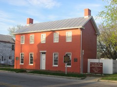 | Levi Coffin House | 0.1 miles | 1966 |
 | King-Dennis Farm | 6.7 miles | 2000 |
 | Abram Gaar House and Farm | 7.8 miles | 1975 |
| Eliason Farm | 7.9 miles | 2019 |
| National Archives record | The nomination case file for reference 100002869 in Record Group 79. |
| Wayne County | All 40 listed properties in this county. |