 Block
From the record
One of 37 National Register listings published here for Carroll County · listed in 2023 · category: Site.
Sources: the National Register database, National Park Service
Listed on the National Register of Historic Places in 2023.
One of 37 National Register listings published here for Carroll County · listed in 2023 · category: Site.
Sources: the National Register database, National Park Service
The chapter on Washington Township in History of Carroll County Indiana, published 1916 names Deer Creek. This is what it says, exactly as the scans read.
Deer Creek is the principal town in the township, situate on the state Michigan road, and during the time of the building of this road was quite a lively place. The various church denominations have their organizations and fine schools are found in this township. Improved roads and per¬ manent iron bridges make this township a model one in the county.
Passage source: History of Carroll County Indiana, published 1916.
Machine-read from a century-old scan, so expect the errors a machine makes: misspelled names, dropped words, stray characters.
Read the whole chapter on Washington Township - 824 words on its settlement, mills, schools and churches.
Regional context, not property-specific evidence. The National Weather Service names Deer Creek, the town this property stands in, in 4 storm reports between 2010 and 2020: 2 thunderstorm wind, 2 tornado. No death or injury is recorded in these reports. Each account below is quoted exactly as the forecast office filed it, from the NOAA Storm Events Database, and each date opens the federal record of that event.
| When | Event | Place named | Harm | What the report says |
|---|---|---|---|---|
| June 2010 | Tornado (EF1) | Deer Creek | $60,000 | A trained spotter reported a tornado silhouetted by lightning in this location. This tornado touched down near County Road 700 N and 500 E in eastern Carroll County around 1:25 AM EDT. Two hog barns were destroyed in the path of this tornado before continuing on into Cass County. Based on the damage observed, this appeared to be a high EF1 tornado with winds approaching 110 mph. |
| June 2010 | Thunderstorm Wind | Deer Creek | $7,500 | A roof was reportedly blown off a barn due to thunderstorm wind gusts. |
| August 2020 | Thunderstorm Wind | Deer Creek | - | A 65 mph thunderstorm wind gust was measured at this location. |
| July 2017 | Tornado (EF1) | Deer Creek | - | Mainly crop damage was observed on the Carroll County side of this EF1 tornado track before heading into Cass County. Overall, crop and tree damage, minor roof damage to a few barns and homes, as well as a recreational vehicle (RV) being lifted and destroyed is what was surveyed from this 95 mph maximum wind tornado. |
No historic map-sheet match is published for this property yet. That does not mean no map exists. This record needs a coordinate-quality review before it can be joined to a sheet boundary. Browse the county's mapped places while that work is pending.
Other National Register properties close enough to walk or drive between, ordered by distance from this one. Both positions come from the same geocoding pass that matched these properties to their map sheets.
| Photograph | Property | Distance | Listed |
|---|---|---|---|
| Wagoner-Ayres House | 4.7 miles | 2024 | |
| Meridian Line Road Iron Truss Bridge | 7.0 miles | 2025 | |
| Camden Paint Creek Concrete Arch Bridge | 7.2 miles | 2025 | |
| Camden First Baptist Church | 7.7 miles | 2023 | |
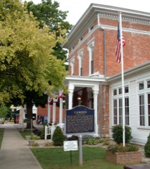 | Andrew Thomas House | 7.8 miles | 1984 |
 | Camden Masonic Temple | 7.8 miles | 2003 |
| National Archives record | The nomination case file for reference 100009297 in Record Group 79. |
| Carroll County | All 37 listed properties in this county. |