BlockBefore
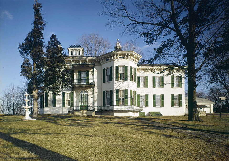
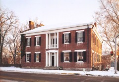
Photograph of Beechwood
Photograph by Jack Boucher, Public domain. Via Wikimedia Commons.

Beechwood (Isaac Kinsey House)

Listed on the National Register of Historic Places in 1975.

From the record

“Beechwood (Isaac Kinsey House) is a historic home and farm located in Washington Township, Wayne County, Indiana. It was built in 1871, and is a two-story, Italianate style brick dwelling with a hipped roof topped by a cupola.”

Wikipedia article Beechwood (Isaac Kinsey House), CC BY-SA 4.0.

One of 40 National Register listings published here for Wayne County · listed in 1975 · category: Building.

Sources: the Wikipedia article · the case file at the National Archives · the National Register database, National Park Service
The listing

  • What is counted as historic. The nomination lists 7 buildingss as contributing to the listing.
  • Address. 2 mi. S of Milton on Sarver Rd., Milton, 47357
  • When was it listed? February 1975
  • Category. building
  • Township. Washington township
  • National Register reference number. 75000031 - the number the National Park Service assigned this property when it was listed, and the key its nomination file is catalogued under at the National Archives.

The ground it stands on

22,771 words

The chapter on Washington Township in History of Wayne County, Indiana, from Its First Settlement to the Present Time : with Numerous Biographical and Family Sketches, published 1872 names Milton. This is what it says, exactly as the scans read.

The earliest settlements in the township are believed to have been in the north part. Thomas Symonds settled December 6, 1811, about a mile north of where Milton now stands, having cut his way through the woods for 12 miles. There was no other settler near. His widow, still living, says, that, for six weeks after their arrival, she did not see the face of a white woman. Mr. Symonds was from IST. C, and had stopped a few months at Cox's settlement, where Eichmond now is. His family consisted of himself and his wife. They were much annoyed by Indian beggars, and by wild animals that approached their cabin by night and by day. In the spring of 1812, from fear of the Indians, they, like other settlers, left their home, and sought safety in the settlements in the vicinity of the present city of Richmond, where they remained until after the pacification of the Indians in 1814. They were obliged to go some 15 miles to mill, until Mr. Symonds himself built a mill, which was completed late in the autumn of 1814, or early in 1815. His wife once made one of these trips to mill, it being deemed safer than to remain at home alone. He died September 30, 1865. His wife is still living at Spiceland, Henry county.

Passage source: History of Wayne County, Indiana, from Its First Settlement to the Present Time : with Numerous Biographical and Family Sketches, published 1872.

In the fall of 1814, Benj. Beeson, from ]S"orth Carolina, settled 31 miles south of the present town of Milton, on land which had been entered in 1812, where he resided until his death in 1852, and where his son Benj. F. Beeson resides.

Passage source: History of Wayne County, Indiana, from Its First Settlement to the Present Time : with Numerous Biographical and Family Sketches, published 1872.

Machine-read from a century-old scan, so expect the errors a machine makes: misspelled names, dropped words, stray characters.

Read the whole chapter on Washington Township - 22,771 words on its settlement, mills, schools and churches.

Mines and quarries near this property

1 within 5 miles

Regional context, not property-specific evidence. The federal mineral resources record lists 1 working within 5 miles of Beechwood (Isaac Kinsey House): 1 producer. All of them still produce. What was taken out: Sand and Gravel, Construction. Distance is straight-line from the map coordinates, so a quarry counted here may appear on a neighbouring settlement's page as well.

Where SiteCommodity StatusRecorded
Cambridge City PitSand and Gravel, ConstructionProducer

Every working recorded in Wayne County

Storms near this property

9 since 1995

Regional context, not property-specific evidence. The National Weather Service names Milton, the town this property stands in, in 9 storm reports between 1995 and 2021: 5 thunderstorm wind, 3 hail, 1 tornado. No death or injury is recorded in these reports. Each account below is quoted exactly as the forecast office filed it, from the NOAA Storm Events Database, and each date opens the federal record of that event.

WhenEvent Place namedHarm What the report says
June 1995Tornado (F0)Milton$15,000A tornado touched down near Indiana State Route One, damaging a 40- by 120-foot barn. The tornado also downed several trees and power lines.
June 2016Thunderstorm WindMilton$11,000Eleven trees were knocked down thoughout Wayne County.
September 2012Thunderstorm WindMilton$10,000Trees and power lines were downed due to damaging thunderstorm winds.
July 1999Thunderstorm WindMilton$5,000Trees and power lines knocked down.
June 2008HailMilton$5,000no account filed
December 2021Thunderstorm WindMilton$4,000Several trees were downed in the Milton area.
July 1996Thunderstorm WindMilton$3,000no account filed
April 2018HailMilton-no account filed
March 2011HailMilton-no account filed

Every storm recorded in Wayne County

Map coverage status

No historic map-sheet match is published for this property yet. That does not mean no map exists. This record needs a coordinate-quality review before it can be joined to a sheet boundary. Browse the county's mapped places while that work is pending.

Listed places nearby

6 within 8 miles

Other National Register properties close enough to walk or drive between, ordered by distance from this one. Both positions come from the same geocoding pass that matched these properties to their map sheets.

Photograph PropertyDistance Listed
Lackey-Overbeck House4.0 miles1976
Conklin-Montgomery House4.1 miles1975
Cambridge City Historic District4.1 miles1991
Huddleston House Tavern, The4.3 miles1975
Witt-Champe-Myers House4.7 miles1995
Dublin Friends Meeting House5.0 miles2018

Sources for this property

National Archives recordThe nomination case file for reference 75000031 in Record Group 79.
Wikipedia articleCommunity-written account of this property, licensed CC BY-SA.
Wayne CountyAll 40 listed properties in this county.

Provenance

  • Listing record. National Park Service National Register of Historic Places, listed-properties dataset, current to 2026-05-22.
  • Map join. Address geocoded through the United States Census geocoder, then tested against the published boundary of every sheet in the USGS Historical Topographic Map Collection.
  • How this page is made. Listing fields come from federal records; map-sheet coverage is a labelled coordinate-to-boundary calculation, not a source-field claim.
  • Mines and quarries. USGS Mineral Resources Data System (MRDS) https://mrdata.usgs.gov/mrds/ A work of the United States government, no copyright under 17 U.S.C. 105.
  • Storms. NOAA National Centers for Environmental Information, Storm Events Database https://www.ncei.noaa.gov/stormevents/ A work of the United States government, no copyright under 17 U.S.C. 105. Narratives are quoted verbatim from the National Weather Service report and are not edited or summarised.